Showing 15689 items
matching the valley
-
 Canterbury History Group
Photograph - Wattle Valley Road view of the Canterbury Mansions. Set of 5 photographs, Jan Pigot, 1994
... Wattle Valley Road view of the Canterbury Mansions. Set of ...Coloured photograph of the Wattle Valley Road view of the 3 storey Victorian Building called Canterbury Mansions.canterbury, canterbury mansions, shops, wattle valley road, victorian architecture -
Canterbury History Group
Photograph - Wattle Valley Road view of the Canterbury Mansions. Set of 5 photographs, Jan Pigot, 1994
... Wattle Valley Road view of the Canterbury Mansions. Set of ...Coloured photograph of the Wattle Valley Road view of the 3 storey Victorian Building called Canterbury Mansions.canterbury, canterbury mansions, shops, wattle valley road, victorian architecture -
 Victorian Harness Racing Heritage Collection at Lord's Raceway Bendigo
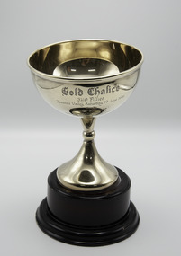
Memorabilia - Gold trophy, Mother Courage, 1999 Gold Chalice 3yo Fillies
Mother Courage (Stoneridge Scooter Imp P 1.50.8 - Talk To Me Vic P 1.59.6 (What's Next)) Bay Mare. Foaled 1995 (3rd Foal) Breeder/Owner: Castle Family Pty Ltd. Trainer B Morgan. Mother Courage raced from 1998 (2yo) through to 2003 (7yo). Career: 30 wins 19 seconds 9 thirds 81 starts $462,520 1.56.9 Winning Drivers: JJ Caldow (27) BR Gath (3). Won on 8 Tracks: Moonee Valley (14) Ballarat (6) Bendigo (2) Horsham (2) Maryborough (2) Kilmore (2) Hamilton (1) Mildura (1)Mother Courage won the 1999 Gold Chalice 3yo Fillies race at Moonee Valley over 2060m at a mile rate of 2.04.5. Driven by JJ Caldow. Defeating Jilliby Magic 2nd and Dame Rainbow 3rd.Cup Shaped Trophy on a Wooden BaseGold Chalice / 3yo Fillies / Moonee Valley Saturday 19 June 1999 / Won by / "Mother Courage" / Proudly donated by the / Victorian Standardbred Breeders & / Studmasters Associationtrophy, harness horse, mother courage, 1999, moonee valley, gold chalice, 3yo fillies, victorian standardbred breeders & studmasters association, jj caldow, john caldow, bruce morgan, b morgan -
 Bendigo Historical Society Inc.
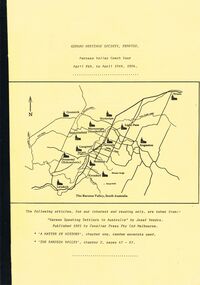
Document - GERMAN HERITAGE SOCIETY COLLECTION: BAROSSA VALLEY COACH TOUR 1994, 8th - 10th April, 1994
Bound collection with a yellow front cover and a buff back cover. Barossa Valley Coach Tour, April 8th to April 10th, 1984. The front has a line map of The Barossa Valley, South Australia. Articles taken from 'German Speaking Settlers in Australia' by Josef Vondra, Published 1981 by Cavalier Press Pty Ltd Melbourne. 'A Matter of History' chapter one, random excerpts used. 'The Barossa Valley', chapter 2, pages 47 - 67. Mentioned in the booklet are the German settlement in the Barossa Valley, the arrival of the Germans in Australia and some of the reasons which led up to why they left their homeland.document, memo, german heritage society, german heritage society collection - barossa valley coach tour 1994, josef vondra, cavalier press pty ltd -
 Kiewa Valley Historical Society
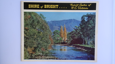
Brochure - Shire of Bright, Shire of Bright Tourist Centre of N.E. Victoria, Pre 1966
... tourism; mt beauty; the kiewa valley; bright shire ...Bright and the surrounding towns were developing a large tourism industry which the Shire of Bright continues to promote, encouraging tourists to visit throughout the year. This high quality brochure has magnificent photos with a map showing the area and the distance (in miles) from the centre - the township of Bright.This brochure is promoting the Shire of Bright encouraging tourism in the area. This is important for the Shire as tourism is the main industry for the Shire. It is interesting to see how tourism has changed (or not) in the area.14 pages on glossy paper including colored and black and white photos. The front cover has the title at the top with yellow print on black background. Below the title is a large colored photo of a river, autumn trees and mountain. The back cover is a large colored photo of a man amongst the snow gums in the snow. The towns covered are Bright, Wandiligong, Eurobin, Mt Buffalo, McKay Creek Power Station, The Kiewa Hydro Electric Scheme, Mt Beauty, Kiewa, Bogong including tourist destinations in these areas and their surrounds.tourism; mt beauty; the kiewa valley; bright shire -
 Marysville & District Historical Society
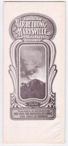
Map (Item) - Tourist Map, Tourists Resorts' Committee, Tourist's Map of Healesville Marysville and Warburton Districts, 13.10.1925
... the acheron valley ...A tourist map for Healesville, Marysville and Warburton that was produced by the Tourists Resorts' Committee. This map was produced in 1925.A tourist map for Healesville, Marysville and Warburton that was produced by the Tourists Resorts' Committee.Photo Lithographed at the Department of Lands and Survey, Melbourne by W.J. Butson./ 13.10.25healesville, marysville, warburton, victoria, tourists resorts' committee, ben cairn, mount donna buang, the black's spur, the acheron valley, narbethong, launching place, tourist information, tourism, map, tourist map -
 Marysville & District Historical Society
Map (Item) - Tourist Map, Department of Lands & Survey, Tourist's Map of Narbethong and Marysville Districts Victoria, 1913
... the acheron valley ...A tourist map for the Narbethong and Marysville Districts that was originally produced by the Department of Lands & Survey in 1925.A tourist map for the Narbethong and Marysville Districts that was originally produced by the Department of Lands & Survey in 1925.Reprint of the 1925 Tourist brochure by permission R.E. Holmes Surveyor General By Authority: ALBERT J. MULLETT, Government Printer, Melbourne. Photo Lithographed at the Department of Lands and Survey Melbourne by W.J. Butson/ 26.8.13narbethong, marysville, victoria, department of lands & survey, the acheron valley, warburton, map, tourist map -
 Kiewa Valley Historical Society
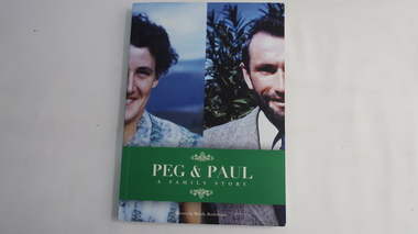
Book - Peg and Paul - A Family Story, Peg and Paul - A Family Story by Wendy Boehringer
... Farming in the Kiewa Valley ...Family History of the Cooper and Boehringer families commencing with John Franklin Cooper 1892-1982 and Gertrude Beatrice Wallace Robinson 1901 - 1991Social history of life in the Kiewa Valley during the 20th Century.Coloured cardboard cover with a photo of the halves of two people. The title is white on green across the bottom third.192 pages cooper family, boehringer family, farming in the kiewa valley -
 Kiewa Valley Historical Society
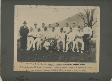
Photo - Running Creek, Photo - Running Creek Cricket Club Premiers UKVCA, Season 1913-14
... Cricket team in 1913-14 in the Kiewa Valley ...Running Creek had a cricket team in 1913-14.The donor Genieve was the granddaughter of Ella Sullivan. Ella was one of 5 daughters of Denis and Margaret (nee Tolmie) Sullivan who lived at Tawonga (Coral Bank). 'Sullivan's Lane'. Ella married John (Jack) Fahey and they lived for some time at Fahey's Lane, Running Creek. J. Fahey is listed as Captain in the photo. The child's name is not known but it is possible it's Jack's son by the sitting position.Sepia coloured large photo of 13 Cricketers and 2 men, one at each end. Underneath the photo is the name of the event and the names of the cricketers and umpire. The photo is mounted on grey cardboard with 'Vine's Studios' and 'Wangaratta' inscribed. running creek, cricket team in 1913-14 in the kiewa valley, genieve meyer -
 Kiewa Valley Historical Society
Papers - Public Record Office re Kiewa Valley
... Court Records in the Kiewa Valley ...1. Mongan's Bridge School No. 3403 - 1 page 2. Tawonga School No. 2282 (& Mullindolingong No. 2551) - 28 pages 3. Court of Petty Sessions VPRS 8557 - 9 pages 4. Tangambalanga History c 1922 - 7 pages.Handwritten in pen the headings mongan's bridge school, tawonga school, mullindolingong school, court records in the kiewa valley -
 Kiewa Valley Historical Society
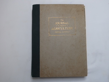
Book of Journals - Agriculture 1949, The Journal of the Department of Agriculture Victoria, Australia
... farmers of the Kiewa Valley ...Each journal has eg January 50 pages and February 100 pages with advertisements, articles, etc updating farmers on current issues and the latest inventions.Farmers in the Kiewa Valley subscribed to these journals enabling them to keep up with the changes in farming in Victoria, Australia.Large, thick book box with monthly journals in 1949 enclosed. Each journal is held by string. Spine is black and cover is beige.department of agriculture in victoria, farmers of the kiewa valley, 1949 journals -
 Marysville & District Historical Society
Map (Item) - Tourist Map, Tourists Resorts' Committee, Tourist's Map of Healesville Marysville and Warburton Districts, 13.10.1925
... the acheron valley ...A tourist map for Healesville, Marysville and Warburton that was produced by the Tourists Resorts' Committee. This map was produced in 1925.A tourist map for Healesville, Marysville and Warburton that was produced by the Tourists Resorts' Committee.Photo Lithographed at the Department of Lands and Survey, Melbourne by W.J. Butson./ 13.10.25healesville, marysville, warburton, victoria, tourists resorts' committee, ben cairn, mount donna buang, the black's spur, the acheron valley, narbethong, launching place, tourist information, tourism, map, tourist map -
 Marysville & District Historical Society
Map (Item) - Tourist Map, Department of Lands & Survey, Tourist's Map of Narbethong and Marysville Districts Victoria, 1913
... the acheron valley ...A tourist map for the Narbethong and Marysville Districts that was originally produced by the Department of Lands & Survey in 1925.A tourist map for the Narbethong and Marysville Districts that was originally produced by the Department of Lands & Survey in 1925.Reprint of the 1925 Tourist brochure by permission R.E. Holmes Surveyor General By Authority: ALBERT J. MULLETT, Government Printer, Melbourne. Photo Lithographed at the Department of Lands and Survey Melbourne by W.J. Butson/ 26.8.13narbethong, marysville, victoria, department of lands & survey, the acheron valley, warburton, map, tourist map -
 Wodonga & District Historical Society Inc
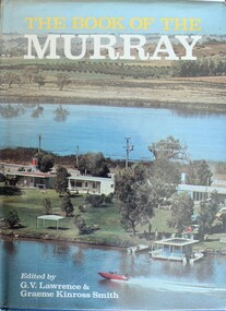
Book - The Book of the Murray, Lawrence, G. V.; and Smith, Graeme Kinross, 1975
... Aborigines in the Murray Valley ...This book contains contributions from 16 writers who have first-hand knowledge of the Murray River area. It provides a comprehensive picture of the river in all its aspects. It gives a fascinating look at one of Australia's most important geographical and historical features. Contributors and chapters in this book are: - 1. Past, Present and Future – G. V. Lawrence 2. The Structure of the Murray – Edmund D. Gill 3. Seeing the Murray – Graeme Kinross Smith 4. The Mountains at the Source – Elyne Mitchell 5. The Explorers – Leigh Betheras 6. The Irrigators – G. Arch Grosvenor 7. Murray Water Conservation – W. G. L. Harrison & K. E. Johnson 8. The Murray River Steamers – Ian Mudie 9. Pioneer Days: A Story of Seventy Years Ago – Dorothy Roysland 10. Birdlife of the Murray Valley – John Eckert 11 .Aborigines in the Murray Valley, How We Learned the Story – H. A. Lindsay, The Aboriginal Occupation – Norman B. Tindale 12. Fish of the Murray River – John S. Lake 13. Native Plants of the Murray Valley – J. H. Willis 14. Murray Wildlife – K. N. G. SimpsonThis publication has a hard cover with blue boards and a pictorial dust jacket. It consists of 264 pages.This book contains contributions from 16 writers who have first-hand knowledge of the Murray River area. It provides a comprehensive picture of the river in all its aspects. It gives a fascinating look at one of Australia's most important geographical and historical features. Contributors and chapters in this book are: - 1. Past, Present and Future – G. V. Lawrence 2. The Structure of the Murray – Edmund D. Gill 3. Seeing the Murray – Graeme Kinross Smith 4. The Mountains at the Source – Elyne Mitchell 5. The Explorers – Leigh Betheras 6. The Irrigators – G. Arch Grosvenor 7. Murray Water Conservation – W. G. L. Harrison & K. E. Johnson 8. The Murray River Steamers – Ian Mudie 9. Pioneer Days: A Story of Seventy Years Ago – Dorothy Roysland 10. Birdlife of the Murray Valley – John Eckert 11 .Aborigines in the Murray Valley, How We Learned the Story – H. A. Lindsay, The Aboriginal Occupation – Norman B. Tindale 12. Fish of the Murray River – John S. Lake 13. Native Plants of the Murray Valley – J. H. Willis 14. Murray Wildlife – K. N. G. Simpsonmurray river, australian geography, settlement on the murray river, native plants, aborigines in the murray valley, murray valley flora and fauna -
Marysville & District Historical Society
Document (item) - Research Document, Judith Vimpani, Hermit of the Cumberland Goldfield-George Ernest Locke, 2020
... hermit of the cumberland valley ...An account of the life of George Ernest Locke who was a gold miner on the Yarra Track near Marysville in Victoria.An account of the life of George Ernest Locke who was a gold miner on the Yarra Track near Marysville in Victoria. George was a well-educated young man and had some success prospecting in the Cumberland area before partnering with William Chester with whom he opened the Golden Bower gold mine in 1896. George and William then discovered a second reef which they named the Silver Bower mine. George lived in a log cabin in the Cumberland reserve and was known to be a loner. He was clever with his money and chose not to have a bank account in Marysville, where everyone would learn about his financial status. He banked at the ES&A in Fitzroy and at the time of his death in 1941 he had accumulated the princely sum of three hundred and sixty pounds. George Locke was known as "the Hermit of Cumberland Valley" and lived in his humpy until his last few days during which he moved into a Forest Commission's patrol hut because his old humpy had started to fall to pieces. When George passed away at the age of 81 years he had not visited Marysville for over 14 years. george ernest locke, gold miner, gold mining, yarra track, william chester, golden bower mine, cumberland goldfield, silver bower mine, chesterville, marysville, victoria, jackie lewis, baron somers, big tree, picea sitchensis exotic, box hill cemetery, john edward locke, annie caroline locke, hermit of the cumberland valley -
 Kew Historical Society Inc
Photograph - Construction of the electric tram line in Riversdale Road, Camberwell
One of a series of photographs, taken by Edgar James Dower in the second decade of the twentieth century. Born and raised in Olinda, his family later moved to Surrey Hills. He worked as an adult as a clerk in the city office of the Metropolitan Gas Company, and in his role as a 'collector', he was able to photograph scenes including the construction of tramlines, railways and associated buildings in Kew, Hawthorn, Camberwell and Surrey Hills. Later he established a real estate agency with his brother - the E.J. Dower Real Estate Agency, Dandenong Office.The image is an historically significant record of the development of transport infrastructure which was used to connect Victorians in the first two decades of the twentieth century. This development resulted from increases in population and the consequent extension of Melbourne's suburbs. The photographs, both individually and collectively, richly detail the labour of workers and the tools and machinery used to create and extend Melbourne's public transport network in the years preceding and during World War 1.Digital copy of an original mounted photograph showing workers excavating Riversdale Road, Camberwell, in preparation for the laying of the new electric tramline.Verso: "Riversdale Road between Wattle Valley and Highfield Roads"theme -- connecting victorians by transport and communications, riversdale road - camberwell (vic.), theme -- travelling by tram -
 Linton and District Historical Society Inc
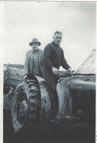
Photograph, Harry Thomas on Tractor
Black and white copy of original photograph showing two men on a tractor, one driving, wearing dark clothes, the other standing behind wearing lighter clothes and a hat."Harry Thomas on Tractor, Happy Valley, Herb Milburn with hat."harry thomas, happy valley, herb milburn, tractor farm -
 Linton and District Historical Society Inc
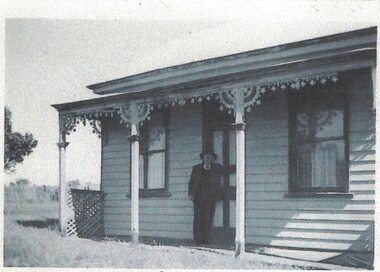
Photograph, Barney's Home
Black and white copy of original photograph showing a gentleman wearing a dark suit and hat standing on the front porch of a weatherboard house, with iron lace decorating the verandah."Happy Valley, Barney's home opposite the Robin Hood Mine"barney mcinneny, happy valley -
Whitehorse Historical Society Inc.
Book - Report, Koonung - Mullum Forestway, c1975
The Koonung-Mullum Freeway : a plan for action. A Report prepared for the Mullum Valley Freeway Action Group and Koonung Valley Action Group, under a grant from the Department of Environment by Ronald Champion Conservation Planning Environment Consultants and Paul Thompson, Rob Paul Landscapes ca1975mullum valley freeway action group, koonung valley action group, champion, randall, thompson, paul, rob paul landscapes, victoria. department of the environment, mullum mullum creek, koonung creek, eastern freeway, forest conservation, parks and reserves -
 Federation University Historical Collection
Book, Yallourn, 10/1962
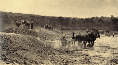
In the foreword the Chairman and General Manager, W.H. Connolly, wrote: "Australia's progress since the Second World War has been remarkable - and nowhere more so than in Victoria. Although the smallest pf the mainland States, Victoria is today the most highly industrialised, the second most populous and the most rapidly developing State in the Commonwealth. Many factors have contributed to this growth, bu the one of greatest importance is the vast wealth of easily extractable brown coal in the Latrobe Valley which is the source of Victoria's electricity and a major part of its solid fuel. ... "White and green soft covered book of 34 pages with black & white and coloured illustrations. The book includes starts with an historical section, and includes information the open cut, Yallourn Power Station, Yallourn Briquette Works, the town, Morwell Open Cut, and includes a map of the Latrobe Valley Brown Coal resources.yallourn, connolly, open cut, power station, kernot, coal, briquette, lyle, monash, yallourn open cut, yallourn power station, yallourn briquette works, morwell open cut, hazelwood, brown coal, gippsland, horses, turning sod -
 Kew Historical Society Inc
Photograph - Yarra Valley Floods: Kew East, 1916
Flooding of the Yarra Valley, including that section of the Yarra bordering Kew and Kew East in the north and west of the municipality, was a regular occurrence. Extreme flood events of the Yarra River are recorded to have occurred in 1891, 1901, 1916, 1923 and 1934. The Municipality of Kew's response to these floods was to enact planning decisions restricting residential development in flood prone areas following the floods of 1916, 1921 and 1934. While floods continued after the development of the Upper Yarra Reservoir (construction 1948-57), the regularity and extent of these inundations diminished. During the nineteenth century, the land abutting the south side of the Yarra in Kew was devoted to dairy farming. In the twentieth century, before and after the construction of the Eastern Freeway, much of this low-lying area was used as golf courses and public parks.One of a collection of photographs of flooding in the Kew section of the Yarra Valley which are in important research resource for the location and extent of flooding in the first half of the twentieth century. Flooding of the Yarra Valley at East Kew in 1916. The view is taken from the intersection of Kilby Road with what is believed to be Birdwood Street, looking across the flood waters to Ivanhoe. The extensive flooded area shown in the photograph would have included the Kew Golf Club. Verso: "Floods along Kilby Road / near Birdwood St? & Kilby Road / 1917? / 87yarra river, yarra valley, floods -- kew, kilby road -- kew (vic.), kew golf club -
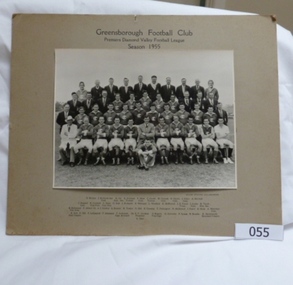 Greensborough Historical Society
Photograph - Team photograph, Greensborough Football Club Premiers Diamond Valley Football League 1955, 1955_
A team photograph of the 1955 Australian Rules Football team from the Greensborough Football Club. Includes players and support staff. This photograph shows all those involved with the Greensborough Football Club in the 1955 Premiership season.Black and white photograph of the Greensborough Football Club Australian Rules Football team, premiers in the Diamond Valley Football League in 1955. Includes players and support team. Mounted on brown card.Greensborough Football Club. Premiers Diamond Valley Football League. Season 1955. Team members: D. Wickes, J. Richards Senior Committee, K. Orr (Assistant Secretary), K. Gillespie (Trainer), F. Marr Committee, C. Cooke (Trainer), W. Connell, Committee, R. Harris, Committee, J. Glare, Committee, A. Mitchell, J. Dudgell, Committee, H.Cockbill (Vice President), T. Hope (Vice President), D. Hall, J. Richards, D. Williams, L. Weidlich, E. McDowell, J. R. Foard (Treasurer), J. Joules Committee, R. Tooth (Honorary Secretary), H. Richmond (Vice President), P. Abbott, Dr. A. J. Stubley, G. Brasier, R. Towler, D. Bell, R. Ormsby, T. Partington, D. McDowell, I. Foard, R. Skals, A. Montfort (Committee), R. Bell (Goal Umpire), F. Hill, F. LeGassick, P. Adamson, F. Anderson (Captain and Coach), Dr. E. P. Cordner (President), D. Rogers (Vice Captain), G. Coventry, F. Green, N. Brooks, H. Arrowsmith (Boundary Umpire).greensborough football club, premiers 1955, doug hall -
Greensborough Historical Society
Article, Laurie McQuade, by Rosie Bray, 2019_
Laurie McQuade is a Watsonia resident, who has volunteered for many years as a Scout leader, member of the Yarrambat CFA and St John's Ambulance. He has received many awards, and is still an active volunteer at the age of 83.3 p. typescript, coloured photographs; with newspaper clipping from Diamond Valley News 23/11/2018laurie macquade, watsonia -
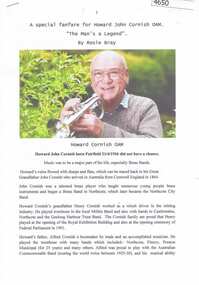 Greensborough Historical Society
Article, A Special fanfare for Howard John Cornish OAM, by Rosie Bray, 14/04/2017
Account of the life of Howard John Cornish, Greensborough resident, cornet player and brass band musician, on the occasion of his award of an OAM in 2017.Typescript, 4 pages , colour photographs; with illustrated article from Diamond Valley Leader 14 June 2017howard john cornish -
Glenelg Shire Council Cultural Collection
Article - Newspaper Clipping - 'Heritage Valley' subdivision at Cape Bridgewater, n.d
Black and white newspaper advertisement for 'Heritage Valley' subdivision at Cape Bridgewater. Elders and Hedditch Real Estate Agentscape bridgewater -
 Halls Gap & Grampians Historical Society
Photograph - B/W, C 1960s
This photo was taken in the Mt William area and was material for a Ministry of Tourism campaign.The photo shows a man seated on a rock and looking out over a valley (Mt William area, south west)'This Photograph is with, The Compliments of The . . . ,Ministry of Tourism, Government of Victoria, Please acknowledge, Photo: Michael Chesire' stamped on back. 'Grampians Mt. William' written on back in red pen.scenery, mount william -
Ringwood and District Historical Society
Envelope, Packet: Dandenong Creek Committee - notes re DVA, Consultation Committee. Correspondence. 1990s
16 pages typed and some handwritten notes Dandenong Valley Authority, Dandenong Creek Community Consultative Committee -
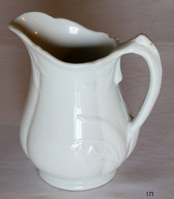 Flagstaff Hill Maritime Museum and Village
Ceramic - Jug, Baker & Co, 1891 to 1893
W Baker and Co-produced many different types of pottery at their Fenton Potteries, Stoke-on-Trent, Staffordshire England. The company was established in 1790 by Ralph Bourne and William Baker the company was working at capacity by the end of the century. By the late 1820's Bourne and Baker, in partnership with John Bourne, had acquired additional works opposite the first in 1833. With the deaths of John Bourne and William Baker, the partnership was dissolved, and then for a short time, the business was carried on by Ralph Bourne and William Baker junior and John Baker. By the early 1840s, William Baker was running it alone and was then using 'machinery for the potteries manufacturing operations in addition to the mill that was producing the raw clay. The business was subsequently carried on by William Baker and Company that were known for the making of printed, sponged, and pearl-white granite ware for export in the early 1880s at the Fenton works between Manor and Fountain Streets. The original works on the south side of City Road were by then an en-caustic tile works, apparently still in the hands of the Baker family. The pottery works flourished under William Baker’s management and by the middle of the nineteenth century with almost 500 employees was the biggest firm in Fenton. An early piece of ironstone Staffordshire pottery now a collector's item showing the types of domestic items that were exported from England to its colonies towards the end of the nineteenth century and into the beginning of the twentieth.Water pitcher ironstone ceramic white with raised embossed Lilly of the valley decoration around handle and lip sections. Marked on bottom, "Royal stone china, Baker and Co, England" with emblem of lion, crown and unicornflagstaff hill, warrnambool, shipwrecked coast, flagstaff hill maritime museum, maritime museum, shipwreck coast, flagstaff hill maritime village, great ocean road, jug, kitchen utensil, kitchen ware, water pitcher -
Lakes Entrance Regional Historical Society (operating as Lakes Entrance History Centre & Museum)
Book, Cunningham Cliff, Aboriginal Scar Tree Bruthen Valley, 2004
Research interpretation and management recommendations for the Aboriginal Scar tree in Bruthen Valley, East Gippsland Victoria by a forestec studentaboriginals, transport, vegetation -
 Whitehorse Historical Society Inc.
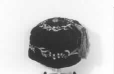
Clothing - Smoking Cap, c1860
Smoking caps, also known as lounging caps, were Victorian headwear worn by men while smoking to stop their hair from smelling of tobacco smoke. Owned by the father of the donor.Black cap with a lily of the valley design around the side and on the crown, and a green and yellow tassel attached. Victorian era.costume, male headware