Showing 972 items matching "tree planting"
-
 Rutherglen Historical Society
Image, 1970s
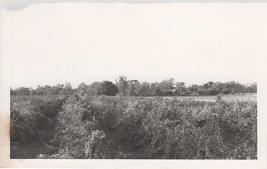
This was the site of some of the first vines that were planted in the Rutherglen grapegrowing area. It is no longer operating as a winery. Established in 1858, Gehrig's is the oldest family winery in Victoria.Black and white photograph with a view over a vineyard. Trees and building with a square tower in the backgroundwineries, north east victoria, wine industry, gehrigs winery -
 Ballarat Heritage Services
Photograph - Digital photographs, L.J. Gervasoni, Boroondara General Cemetery Gatehouse, c2005-2015
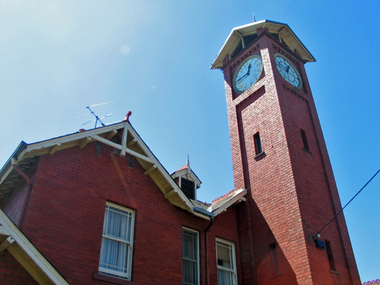
The Boroondara General Cemetery is registerd by Heritage VictoriaBoroondara Cemetery in kew was established in 1858. It has an unusual triangular reserve bounded by High Street, Park Hill Road and Victoria Park, Kew. The caretaker's lodge and administrative office (1860 designed by Charles Vickers, additions, 1866-1899 by Albert Purchas) form a picturesque two-storey brick structure with a slate roof and clock tower. A rotunda or shelter (1890, Albert Purchas) is located in the centre of the cemetery: this has an octagonal hipped roof with fish scale slates and a decorative brick base with a tessellated floor and timber seating. The cemetery is surrounded by a 2.7 metre high ornamental red brick wall (1895-96, Albert Purchas) with some sections of vertical iron palisades between brick pillars. Albert Purchas was a prominent Melbourne architect who was the Secretary of the Melbourne General Cemetery from 1852 to 1907 and Chairman of the Boroondara Cemetery Board of Trustees from 1867 to 1909. He made a significant contribution to the design of the Boroondara Cemetery Boroondara Cemetery is an outstanding example of the Victorian Garden Cemetery movement in Victoria, retaining key elements of the style, despite overdevelopment which has obscured some of the paths and driveways. Elements of the style represented at Boroondara include an ornamental boundary fence, a system of curving paths which are kerbed and follow the site's natural contours, defined views, recreational facilities such as the rotunda, a landscaped park like setting, sectarian divisions for burials, impressive monuments, wrought and cast iron grave surrounds and exotic symbolic plantings. In the 1850s cemeteries were located on the periphery of populated areas because of concerns about diseases like cholera. They were designed to be attractive places for mourners and visitors to walk and contemplate. Typically cemeteries were arranged to keep religions separated and this tended to maintain links to places of origin, reflecting a migrant society. Other developments included cast iron entrance gates, built in 1889 to a design by Albert Purchas; a cemetery shelter or rotunda, built in 1890, which is a replica of one constructed in the Melbourne General Cemetery in the same year; an ornamental brick fence erected in 1896-99(?); the construction and operation of a terminus for a horse tram at the cemetery gates during 1887-1915; and the Springthorpe Memorial built between 1897 and 1907. A brick cremation wall and a memorial rose garden were constructed near the entrance in the mid- twentieth century(c.1955-57) and a mausoleum completed in 2001.The maintenance shed/depot close to High Street was constructed in 1987. The original entrance was altered in 2000 and the original cast iron gates moved to the eastern entrance of the Mausoleum. Some notable memorials include The Springthorpe Memorial (VHR 522), The Syme Memorial (1908), The Cussen Memorial (VHR 2036). Burials within the cemetery include the Henty family, artists Louis Buvelot and Charles Nuttall, businessmen John Halfey and publisher David Syme, artist and diarist Georgiana McCrae, actress Nellie Stewart and architect and designer of the Boroondara and Melbourne General Cemeteries, Albert Purchas. The Boroondara Cemetery features many plants, mostly conifers and shrubs of funerary symbolism, which line the boundaries, road and pathways, and frame the cemetery monuments or are planted on graves. The major plantings include an impressive row of Bhutan Cypress (Cupressus torulosa), interplanted with Sweet Pittosporum (Pittosporum undulatum), and a few Pittosporum crassifolium, along the High Street and Parkhill Street, where the planting is dominated by Sweet Pittosporum. Planting within the cemetery includes rows and specimen trees of Bhutan Cypress and Italian Cypress (Cupressus sempervirens), including a row with alternate plantings of both species. The planting includes an unusual "squat" form of an Italian Cypress. More of these trees probably lined the cemetery roads and paths. Also dominating the cemetery landscape near the Rotunda is a stand of 3 Canary Island Pines (Pinus canariensis), a Bunya Bunya Pine (Araucaria bidwillii) and a Weeping Elm (Ulmus glabra 'Camperdownii'). Amongst the planting are the following notable conifers: a towering Bunya Bunya Pine (Araucaria bidwillii), a Coast Redwood (Sequoia sempervirens), a rare Golden Funeral Cypress (Chamaecyparis funebris 'Aurea'), two large Funeral Cypress (Chamaecyparis funebris), and the only known Queensland Kauri (Agathis robusta) in a cemetery in Victoria. The Cemetery records, including historical plans of the cemetery from 1859, are held by the administration and their retention enhances the historical significance of the Cemetery. Digital images of a red brick gatehouse at Boroondara General Cemetery in Kew.cemetery, boroondara, kew, gatehouse, clock, tower, clocktower, heritage, memorial -
 Ballarat Heritage Services
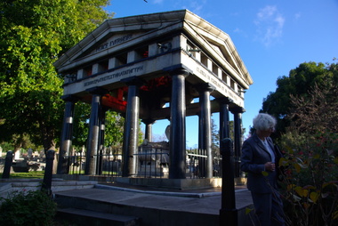
Photograph - Digital photographs, L.J. Gervasoni, Boroondara General Cemetery Springthorpe Memorial, c2005-2015
The Boroondara General Cemetery is registerd by Heritage VictoriaFrom Heritage Victoria Statement of Significance Last updated on - December 15, 2005 What is significant? Boroondara Cemetery, established in 1858, is within an unusual triangular reserve bounded by High Street, Park Hill Road and Victoria Park, Kew. The caretaker's lodge and administrative office (1860 designed by Charles Vickers, additions, 1866-1899 by Albert Purchas) form a picturesque two-storey brick structure with a slate roof and clock tower. A rotunda or shelter (1890, Albert Purchas) is located in the centre of the cemetery: this has an octagonal hipped roof with fish scale slates and a decorative brick base with a tessellated floor and timber seating. The cemetery is surrounded by a 2.7 metre high ornamental red brick wall (1895-96, Albert Purchas) with some sections of vertical iron palisades between brick pillars. Albert Purchas was a prominent Melbourne architect who was the Secretary of the Melbourne General Cemetery from 1852 to 1907 and Chairman of the Boroondara Cemetery Board of Trustees from 1867 to 1909. He made a significant contribution to the design of the Boroondara Cemetery Boroondara Cemetery is an outstanding example of the Victorian Garden Cemetery movement in Victoria, retaining key elements of the style, despite overdevelopment which has obscured some of the paths and driveways. Elements of the style represented at Boroondara include an ornamental boundary fence, a system of curving paths which are kerbed and follow the site's natural contours, defined views, recreational facilities such as the rotunda, a landscaped park like setting, sectarian divisions for burials, impressive monuments, wrought and cast iron grave surrounds and exotic symbolic plantings. In the 1850s cemeteries were located on the periphery of populated areas because of concerns about diseases like cholera. They were designed to be attractive places for mourners and visitors to walk and contemplate. Typically cemeteries were arranged to keep religions separated and this tended to maintain links to places of origin, reflecting a migrant society. Other developments included cast iron entrance gates, built in 1889 to a design by Albert Purchas; a cemetery shelter or rotunda, built in 1890, which is a replica of one constructed in the Melbourne General Cemetery in the same year; an ornamental brick fence erected in 1896-99(?); the construction and operation of a terminus for a horse tram at the cemetery gates during 1887-1915; and the Springthorpe Memorial built between 1897 and 1907. A brick cremation wall and a memorial rose garden were constructed near the entrance in the mid- twentieth century(c.1955-57) and a mausoleum completed in 2001.The maintenance shed/depot close to High Street was constructed in 1987. The original entrance was altered in 2000 and the original cast iron gates moved to the eastern entrance of the Mausoleum. The Springthorpe Memorial (VHR 522) set at the entrance to the burial ground commemorates Annie Springthorpe, and was erected between 1897 and 1907 by her husband Dr John Springthorpe. It was the work of the sculptor Bertram Mackennal, architect Harold Desbrowe Annear, landscape designer and Director of the Melbourne Bortanic Gardens, W.R. Guilfoyle, with considerable input from Dr Springthorpe The memorial is in the form of a small temple in a primitive Doric style. It was designed by Harold Desbrowe Annear and includes Bertram Mackennal sculptures in Carrara marble. Twelve columns of deep green granite from Scotland support a Harcourt granite superstructure. The roof by Brooks Robinson is a coloured glass dome, which sits within the rectangular form and behind the pediments. The sculptural group raised on a dais, consists of the deceased woman lying on a sarcophagus with an attending angel and mourner. The figure of Grief crouches at the foot of the bier and an angel places a wreath over Annie's head, symbolising the triumph of immortal life over death. The body of the deceased was placed in a vault below. The bronze work is by Marriots of Melbourne. Professor Tucker of the University of Melbourne composed appropriate inscriptions in English and archaic Greek lettering.. The floor is a geometric mosaic and the glass dome roof is of Tiffany style lead lighting in hues of reds and pinks in a radiating pattern. The memorial originally stood in a landscape triangular garden of about one acre near the entrance to the cemetery. However, after Dr Springthorpe's death in 1933 it was found that transactions for the land had not been fully completed so most of it was regained by the cemetery. A sundial and seat remain. The building is almost completely intact. The only alteration has been the removal of a glass canopy over the statuary and missing chains between posts. The Argus (26 March 1933) considered the memorial to be the most beautiful work of its kind in Australia. No comparable buildings are known. The Syme Memorial (1908) is a memorial to David Syme, political economist and publisher of the Melbourne Age newspaper. The Egyptian memorial designed by architect Arthur Peck is one of the most finely designed and executed pieces of monumental design in Melbourne. It has a temple like form with each column having a different capital detail. These support a cornice that curves both inwards and outwards. The tomb also has balustradings set between granite piers which create porch spaces leading to the entrance ways. Two variegated Port Jackson Figs are planted at either end. The Cussen Memorial (VHR 2036) was constructed in 1912-13 by Sir Leo Cussen in memory of his young son Hubert. Sir Leo Finn Bernard Cussen (1859-1933), judge and member of the Victorian Supreme Court in 1906. was buried here. The family memorial is one of the larger and more impressive memorials in the cemetery and is an interesting example of the 1930s Gothic Revival style architecture. It takes the form of a small chapel with carvings, diamond shaped roof tiles and decorated ridge embellishing the exterior. By the 1890s, the Boroondara Cemetery was a popular destination for visitors and locals admiring the beauty of the grounds and the splendid monuments. The edge of suburban settlement had reached the cemetery in the previous decade. Its Victorian garden design with sweeping curved drives, hill top views and high maintenance made it attractive. In its Victorian Garden Cemetery design, Boroondara was following an international trend. The picturesque Romanticism of the Pere la Chaise garden cemetery established in Paris in 1804 provided a prototype for great metropolitan cemeteries such as Kensal Green (1883) and Highgate (1839) in London and the Glasgow Necropolis (1831). Boroondara Cemetery was important in establishing this trend in Australia. The cemetery's beauty peaked with the progressive completion of the spectacular Springthorpe Memorial between 1899 and 1907. From about the turn of the century, the trustees encroached on the original design, having repeatedly failed in attempts to gain more land. The wide plantations around road boundaries, grassy verges around clusters of graves in each denomination, and most of the landscaped surround to the Springthorpe memorial are now gone. Some of the original road and path space were resumed for burial purposes. The post war period saw an increased use of the Cemetery by newer migrant groups. The mid- to late- twentieth century monuments were often placed on the grassed edges of the various sections and encroached on the roadways as the cemetery had reached the potential foreseen by its design. These were well tended in comparison with Victorian monuments which have generally been left to fall into a state of neglect. The Boroondara Cemetery features many plants, mostly conifers and shrubs of funerary symbolism, which line the boundaries, road and pathways, and frame the cemetery monuments or are planted on graves. The major plantings include an impressive row of Bhutan Cypress (Cupressus torulosa), interplanted with Sweet Pittosporum (Pittosporum undulatum), and a few Pittosporum crassifolium, along the High Street and Parkhill Street, where the planting is dominated by Sweet Pittosporum. Planting within the cemetery includes rows and specimen trees of Bhutan Cypress and Italian Cypress (Cupressus sempervirens), including a row with alternate plantings of both species. The planting includes an unusual "squat" form of an Italian Cypress. More of these trees probably lined the cemetery roads and paths. Also dominating the cemetery landscape near the Rotunda is a stand of 3 Canary Island Pines (Pinus canariensis), a Bunya Bunya Pine (Araucaria bidwillii) and a Weeping Elm (Ulmus glabra 'Camperdownii') Amongst the planting are the following notable conifers: a towering Bunya Bunya Pine (Araucaria bidwillii), a Coast Redwood (Sequoia sempervirens), a rare Golden Funeral Cypress (Chamaecyparis funebris 'Aurea'), two large Funeral Cypress (Chamaecyparis funebris), and the only known Queensland Kauri (Agathis robusta) in a cemetery in Victoria. The Cemetery records, including historical plans of the cemetery from 1859, are held by the administration and their retention enhances the historical significance of the Cemetery. How is it significant? Boroondara Cemetery is of aesthetic, architectural, scientific (botanical) and historical significance to the State of Victoria. Why is it significant? The Boroondara Cemetery is of historical and aesthetic significance as an outstanding example of a Victorian garden cemetery. The Boroondara Cemetery is of historical significance as a record of Victorian life from the 1850s, and the early settlement of Kew. It is also significant for its ability to demonstrate, through the design and location of the cemetery, attitudes towards burial, health concerns and the importance placed on religion, at the time of its establishment. The Boroondara Cemetery is of architectural significance for the design of the gatehouse or sexton's lodge and cemetery office (built in stages from 1860 to 1899), the ornamental brick perimeter fence and elegant cemetery shelter to the design of prominent Melbourne architects, Charles Vickers (for the original 1860 cottage) and Albert Purchas, cemetery architect and secretary from 1864 to his death in 1907. The Boroondara Cemetery has considerable aesthetic significance which is principally derived from its tranquil, picturesque setting; its impressive memorials and monuments; its landmark features such as the prominent clocktower of the sexton's lodge and office, the mature exotic plantings, the decorative brick fence and the entrance gates; its defined views; and its curving paths. The Springthorpe Memorial (VHR 522), the Syme Memorial and the Cussen Memorial (VHR 2036), all contained within the Boroondara Cemetery, are of aesthetic and architectural significance for their creative and artistic achievement. The Boroondara Cemetery is of scientific (botanical) significance for its collection of rare mature exotic plantings. The Golden Funeral Cypress, (Chamaecyparis funebris 'Aurea') is the only known example in Victoria. The Boroondara Cemetery is of historical significance for the graves, monuments and epitaphs of a number of individuals whose activities have played a major part in Australia's history. They include the Henty family, artists Louis Buvelot and Charles Nuttall, businessmen John Halfey and publisher David Syme, artist and diarist Georgiana McCrae, actress Nellie Stewart and architect and designer of the Boroondara and Melbourne General Cemeteries, Albert Purchas.Digital image of the Springthorpe Memorial in the Boroondara General Cemeterycemetery, boroondara, kew, gatehouse, clock, tower, clocktower, heritage, memorial, springthorpe memorial -
 Ballarat Heritage Services
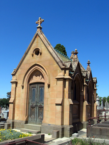
Photograph - Digital photographs, Cussen Memorial in the Boroondara General Cemetery, Kew, Victoria, c2005-2015
The Boroondara General Cemetery is registerd by Heritage VictoriaFrom Heritage Victoria Statement of Significance Last updated on - December 15, 2005 What is significant? Boroondara Cemetery, established in 1858, is within an unusual triangular reserve bounded by High Street, Park Hill Road and Victoria Park, Kew. The caretaker's lodge and administrative office (1860 designed by Charles Vickers, additions, 1866-1899 by Albert Purchas) form a picturesque two-storey brick structure with a slate roof and clock tower. A rotunda or shelter (1890, Albert Purchas) is located in the centre of the cemetery: this has an octagonal hipped roof with fish scale slates and a decorative brick base with a tessellated floor and timber seating. The cemetery is surrounded by a 2.7 metre high ornamental red brick wall (1895-96, Albert Purchas) with some sections of vertical iron palisades between brick pillars. Albert Purchas was a prominent Melbourne architect who was the Secretary of the Melbourne General Cemetery from 1852 to 1907 and Chairman of the Boroondara Cemetery Board of Trustees from 1867 to 1909. He made a significant contribution to the design of the Boroondara Cemetery Boroondara Cemetery is an outstanding example of the Victorian Garden Cemetery movement in Victoria, retaining key elements of the style, despite overdevelopment which has obscured some of the paths and driveways. Elements of the style represented at Boroondara include an ornamental boundary fence, a system of curving paths which are kerbed and follow the site's natural contours, defined views, recreational facilities such as the rotunda, a landscaped park like setting, sectarian divisions for burials, impressive monuments, wrought and cast iron grave surrounds and exotic symbolic plantings. In the 1850s cemeteries were located on the periphery of populated areas because of concerns about diseases like cholera. They were designed to be attractive places for mourners and visitors to walk and contemplate. Typically cemeteries were arranged to keep religions separated and this tended to maintain links to places of origin, reflecting a migrant society. Other developments included cast iron entrance gates, built in 1889 to a design by Albert Purchas; a cemetery shelter or rotunda, built in 1890, which is a replica of one constructed in the Melbourne General Cemetery in the same year; an ornamental brick fence erected in 1896-99(?); the construction and operation of a terminus for a horse tram at the cemetery gates during 1887-1915; and the Springthorpe Memorial built between 1897 and 1907. A brick cremation wall and a memorial rose garden were constructed near the entrance in the mid- twentieth century(c.1955-57) and a mausoleum completed in 2001.The maintenance shed/depot close to High Street was constructed in 1987. The original entrance was altered in 2000 and the original cast iron gates moved to the eastern entrance of the Mausoleum. The Springthorpe Memorial (VHR 522) set at the entrance to the burial ground commemorates Annie Springthorpe, and was erected between 1897 and 1907 by her husband Dr John Springthorpe. It was the work of the sculptor Bertram Mackennal, architect Harold Desbrowe Annear, landscape designer and Director of the Melbourne Bortanic Gardens, W.R. Guilfoyle, with considerable input from Dr Springthorpe The memorial is in the form of a small temple in a primitive Doric style. It was designed by Harold Desbrowe Annear and includes Bertram Mackennal sculptures in Carrara marble. Twelve columns of deep green granite from Scotland support a Harcourt granite superstructure. The roof by Brooks Robinson is a coloured glass dome, which sits within the rectangular form and behind the pediments. The sculptural group raised on a dais, consists of the deceased woman lying on a sarcophagus with an attending angel and mourner. The figure of Grief crouches at the foot of the bier and an angel places a wreath over Annie's head, symbolising the triumph of immortal life over death. The body of the deceased was placed in a vault below. The bronze work is by Marriots of Melbourne. Professor Tucker of the University of Melbourne composed appropriate inscriptions in English and archaic Greek lettering.. The floor is a geometric mosaic and the glass dome roof is of Tiffany style lead lighting in hues of reds and pinks in a radiating pattern. The memorial originally stood in a landscape triangular garden of about one acre near the entrance to the cemetery. However, after Dr Springthorpe's death in 1933 it was found that transactions for the land had not been fully completed so most of it was regained by the cemetery. A sundial and seat remain. The building is almost completely intact. The only alteration has been the removal of a glass canopy over the statuary and missing chains between posts. The Argus (26 March 1933) considered the memorial to be the most beautiful work of its kind in Australia. No comparable buildings are known. The Syme Memorial (1908) is a memorial to David Syme, political economist and publisher of the Melbourne Age newspaper. The Egyptian memorial designed by architect Arthur Peck is one of the most finely designed and executed pieces of monumental design in Melbourne. It has a temple like form with each column having a different capital detail. These support a cornice that curves both inwards and outwards. The tomb also has balustradings set between granite piers which create porch spaces leading to the entrance ways. Two variegated Port Jackson Figs are planted at either end. The Cussen Memorial (VHR 2036) was constructed in 1912-13 by Sir Leo Cussen in memory of his young son Hubert. Sir Leo Finn Bernard Cussen (1859-1933), judge and member of the Victorian Supreme Court in 1906. was buried here. The family memorial is one of the larger and more impressive memorials in the cemetery and is an interesting example of the 1930s Gothic Revival style architecture. It takes the form of a small chapel with carvings, diamond shaped roof tiles and decorated ridge embellishing the exterior. By the 1890s, the Boroondara Cemetery was a popular destination for visitors and locals admiring the beauty of the grounds and the splendid monuments. The edge of suburban settlement had reached the cemetery in the previous decade. Its Victorian garden design with sweeping curved drives, hill top views and high maintenance made it attractive. In its Victorian Garden Cemetery design, Boroondara was following an international trend. The picturesque Romanticism of the Pere la Chaise garden cemetery established in Paris in 1804 provided a prototype for great metropolitan cemeteries such as Kensal Green (1883) and Highgate (1839) in London and the Glasgow Necropolis (1831). Boroondara Cemetery was important in establishing this trend in Australia. The cemetery's beauty peaked with the progressive completion of the spectacular Springthorpe Memorial between 1899 and 1907. From about the turn of the century, the trustees encroached on the original design, having repeatedly failed in attempts to gain more land. The wide plantations around road boundaries, grassy verges around clusters of graves in each denomination, and most of the landscaped surround to the Springthorpe memorial are now gone. Some of the original road and path space were resumed for burial purposes. The post war period saw an increased use of the Cemetery by newer migrant groups. The mid- to late- twentieth century monuments were often placed on the grassed edges of the various sections and encroached on the roadways as the cemetery had reached the potential foreseen by its design. These were well tended in comparison with Victorian monuments which have generally been left to fall into a state of neglect. The Boroondara Cemetery features many plants, mostly conifers and shrubs of funerary symbolism, which line the boundaries, road and pathways, and frame the cemetery monuments or are planted on graves. The major plantings include an impressive row of Bhutan Cypress (Cupressus torulosa), interplanted with Sweet Pittosporum (Pittosporum undulatum), and a few Pittosporum crassifolium, along the High Street and Parkhill Street, where the planting is dominated by Sweet Pittosporum. Planting within the cemetery includes rows and specimen trees of Bhutan Cypress and Italian Cypress (Cupressus sempervirens), including a row with alternate plantings of both species. The planting includes an unusual "squat" form of an Italian Cypress. More of these trees probably lined the cemetery roads and paths. Also dominating the cemetery landscape near the Rotunda is a stand of 3 Canary Island Pines (Pinus canariensis), a Bunya Bunya Pine (Araucaria bidwillii) and a Weeping Elm (Ulmus glabra 'Camperdownii') Amongst the planting are the following notable conifers: a towering Bunya Bunya Pine (Araucaria bidwillii), a Coast Redwood (Sequoia sempervirens), a rare Golden Funeral Cypress (Chamaecyparis funebris 'Aurea'), two large Funeral Cypress (Chamaecyparis funebris), and the only known Queensland Kauri (Agathis robusta) in a cemetery in Victoria. The Cemetery records, including historical plans of the cemetery from 1859, are held by the administration and their retention enhances the historical significance of the Cemetery. How is it significant? Boroondara Cemetery is of aesthetic, architectural, scientific (botanical) and historical significance to the State of Victoria. Why is it significant? The Boroondara Cemetery is of historical and aesthetic significance as an outstanding example of a Victorian garden cemetery. The Boroondara Cemetery is of historical significance as a record of Victorian life from the 1850s, and the early settlement of Kew. It is also significant for its ability to demonstrate, through the design and location of the cemetery, attitudes towards burial, health concerns and the importance placed on religion, at the time of its establishment. The Boroondara Cemetery is of architectural significance for the design of the gatehouse or sexton's lodge and cemetery office (built in stages from 1860 to 1899), the ornamental brick perimeter fence and elegant cemetery shelter to the design of prominent Melbourne architects, Charles Vickers (for the original 1860 cottage) and Albert Purchas, cemetery architect and secretary from 1864 to his death in 1907. The Boroondara Cemetery has considerable aesthetic significance which is principally derived from its tranquil, picturesque setting; its impressive memorials and monuments; its landmark features such as the prominent clocktower of the sexton's lodge and office, the mature exotic plantings, the decorative brick fence and the entrance gates; its defined views; and its curving paths. The Springthorpe Memorial (VHR 522), the Syme Memorial and the Cussen Memorial (VHR 2036), all contained within the Boroondara Cemetery, are of aesthetic and architectural significance for their creative and artistic achievement. The Boroondara Cemetery is of scientific (botanical) significance for its collection of rare mature exotic plantings. The Golden Funeral Cypress, (Chamaecyparis funebris 'Aurea') is the only known example in Victoria. The Boroondara Cemetery is of historical significance for the graves, monuments and epitaphs of a number of individuals whose activities have played a major part in Australia's history. They include the Henty family, artists Louis Buvelot and Charles Nuttall, businessmen John Halfey and publisher David Syme, artist and diarist Georgiana McCrae, actress Nellie Stewart and architect and designer of the Boroondara and Melbourne General Cemeteries, Albert Purchas.Digital imagescemetery, boroondara, kew, gatehouse, clock, tower, clocktower, heritage, memorial, cussen -
 Ballarat Heritage Services
Photograph - Photograph - Colour, Clare Gervasoni, Chinese Section in the Bendigo Cemetery, 2018, 01/09/2018
... as the tree of life) was planted on 9 October 1996 in recognition... as the tree of life) was planted on 9 October 1996 in recognition ...Colour photograph of the Chinese section in the Bendigo Cemetery.A plaque states: This Pomelo Tree (known to the Chinese as the tree of life) was planted on 9 October 1996 in recognition and to the memory of the many Chinese buried at or in close proximity to this site during the 19th and 20th centuries. bendigo cemetery, graves, headstones, chinese, oven -
 Ballarat Heritage Services
Photograph - digital photographs, Clare Gervasoni, Laurie Sullivan's Wollemi Pine Memorial at the Laurie Sullivan Reserve, Hepburn, 2020, 16/09/2020
Laurie Sullivan lived in Hepburn Springs, except for service during World War Two. He was captured in Crete and aa prisoner of war under the German Army. A Stalwart of the Hepburn Football Club, the football ground was named in his honour. Colour photograph of a Wollemi Pine planted for Laurie Sullivan at the Laurie Sullivan Reserve, Hepburn. H.F.C. In memory of Laurie Sullivan 21-6-2006hepburn, laurie sullivan, memorial, wollemi pine, hepburn football ground, laurie sullivan reserve, memorial tree -
 Ballarat Heritage Services
Photograph - Photograph - Colour, Clare Gervasoni, Aleppo Pine, Tower Hill Cemetery, 2019, 03/01/2019
The Tower Hill Cemetery is located near Koroit on the north side of the Princes Highway The, between Port Fairy and Warrnambool. The first burial at Tower Hill Cemetery took place in 1856. Over 150 years there has been over 8,000 burials. Around 45 percent of the burials are in unmarked graves. In 2023 this tree was no longer in existence, and a smaller tree was struggling in this site.Colour photographs of an Aleppo Pine planted in the Tower Hill Cemetery to mark the centenary of the landing at Galipolli.aleppo pine, anzac centenary, centenary, anniversary, tower hill cemetery, gallipoli -
 Ballarat Heritage Services
Photograph - Colour, Clare Gervasoni, Begonia Conservatory in the Wombat Botanical Gardens, Daylesford, 2019, 23/04/2019
Daylesford's begonia collection was stared by French born curator W. Gascoigne in 1885. He was an experienced horticulturalist. The plants were grown again in the 1930s in a new glasshouse. Curator Bill Greville obtained 45 plants from the Ballarat City Council, 30 from Queens Park in Essendon, and soon haad 250 tubers including a (lost) one named 'Daylesford'. When Alf Headland was appointed part-time caretaker in 1956, he found tw tubers in the wood shed and became expert in their cultivation. He continuted well into his retirement when Greg Rae too over. In 1988 the conservotory was named to honur Alf Headland's work.Hot house in the Wombat Gardens with a Begonia display.wombat botanical gardens, daylesford botanical gardens, daylesford, trees, begonia, begonia house, begonia conservatory -
 Ballarat Heritage Services
Photograph - Colour, Aleppo Pine in the Ballaarat Old Cemetery, 2016, 05 June 1016
A small Aleppo Pine planted in the Ballaarat Old Cemetery on 25 April 2015 to commemorate the centenary of the Gallipoli landing. This tree is genetically related to the Lone Pine at Gallipoli. gallipoli, centenary, ballaarat old cemetery, ballarat old cemetery, aleppo pine, lone pine, anzac centenary -
 Ballarat Heritage Services
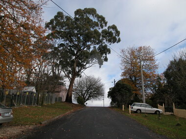
Photograph - Colour, Clare Gervasoni, Zelman Gumtree, Seventh Street, Hepburn Springs, 2004, 28/06/2004
A gum tree on the edge of Seventh Street, Hepburn Springs, that was planted by Victor Zelman of Zelman Cottage.hepburn springs, seventh street, victor zelman, zelman cottage, gum tree -
 City of Ballarat Libraries
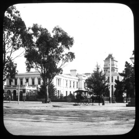
Glass Slide, Ballarat Hospital
The blue gums originally planted in Sturt St in the 1860s were grown from seed gifted by Baron von Mueller. About 20 years later shopkeepers complained that the trees shaded their shops too well, and made the street damp. The bluegums were then replaced with exotics.Previously unknown image of Ballarat. The set and its subjects indicate these images were produced to promote Ballarat and were perhaps aimed at tourists.Ballarat Hospital, nw corner Sturt and Drummond Streets, image not dated.gas lamps, horse and cart -
 Ballarat Heritage Services
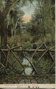
Postcard, Ballarat Botanical Gardens, c1908
"Within six years of its first land sales in 1852, founder members had challenged council over horticultural decisions and Ballarat's main thoroughfare contained fences squares, trees and flower beds. The major works that projected the Garden City image were the street plantings, parks and botanical gardens ..." Reference: Michael Taffe, Growing a garden City: Ballarat Horticultural Society 1859-2009, BHS Publishing, 2014, p. 10.This postcard shows how the botanical gardens in Ballarat, famous for being a Garden City.Coloured postcard Forest Scene, Botanical Gardens, Ballarat printed in red at bottom of card. Elaine 30-11-08 handwritten in black ink underneath.botanical gardens, ballarat, forest scene, gardens, botanical, -
 Hume City Civic Collection
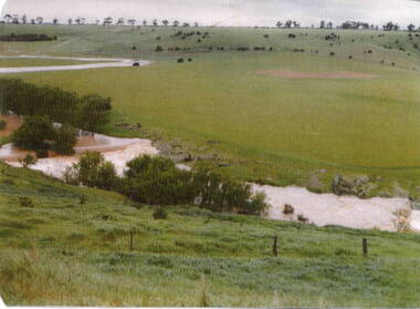
Photograph, Mill Falls
The photograph is of the Jacksons Creek taken in the vicinity of Mill Falls, near the former 'Springvale' winery, which was downstream from the Sunbury township. In 1971 the Shire of Bulla purchased 'Springvale' site and established the town's sewerage plant.The former 'Springvale' winery was one of a number of wineries that were established in Sunbury in the 19th century.A scanned coloured photograph with rounded corners of a valley with a meandering stream with a small dammed section in the foreground. There is a line of trees across the distant hilltops. mill falls, springvale winery, jacksons creek -
Hume City Civic Collection
Pamphlet, Shire of Bulla: Free Trees for Ratepayers, PlantingHints, 16th May 1992
These leaflets were distributed free of charge to residents in the former Shire of Bulla. They listed thirty-one Australian native trees that were suitable to plant in gardens in the area as well as planting hintsThe purpose of giving out free trees was to make residents aware of the importance of planting native flora in the area to encourage wild life.A four page printed leaflet containing a list of suitable trees available to ratepayers living in the former Shire of Bulla.bulla shire council, native trees, garden hints -
 RMIT Design Archives
Diazotypes, Sketch Plan: Garden Layout - 13 Edward St. Kew
John and Phyllis Murphy designed this house and garden in Kew for Sir Frank and Lady Macfarlane Burnet in 1959, the year before Burnet and Peter Medaware received the Nobel Prize for discovering acquired immunological tolerance. For the most highly honoured scientist to have worked in Australia, Burnet's house is modest - single storey with two bedrooms. Typical of post-war suburban housing thought, the garden is a generous, and the planting a mix of existing shrubs and trees, old favourites such as camelias, hydrangeas, lilacs, and a unusually 'a thick copse of native trees'. John Murphy (1920-2004) and Phyllis Murphy (nee Slater) (1924-) are alumni of RMIT. John commenced his architectural studies at Swinburne Technical College prior to WW2, and subsequently studied at Melbourne Technical College (now RMIT University) from 1944 to 1946. Phyllis studied architecture at Melbourne Technical College from 1942, before transferring to Melbourne University's Architectural Atelier in 1944 They both completed their Bachelor of Architecture in 1949, with Phyllis topping the fourth year, and John coming in second. They established their architectural practice in 1950. One early project was their design with Kevin Borland and Peter McIntyre for the Olympic Swimming Pool (1956). Ann Carew 2018dye, paper, garden design, kew -
 Ballarat RSL Sub-Branch Inc.
Photograph - Memorial Tree
This object relates to Gordon FINK. He was born on 18/01/1885 in Melbourne, VIC. Gordon served in the AIF (674) enlisting on, 18/11/1914 in Melbourne, VIC before being killed in action on duties with the 16 BATTN as a Army Non-Commissioned Private (PTE) on 02/05/1915. Gordon FINK was not a prisoner of war. His next of kin is Theodore FINK (Father)"In Honour of Pte Gordon Fink 16th Batt. Killed In Action, Popes Hill, GALLIPOLI May 2nd 1915 Aged 30yrs Planted by his Family"first world war (ww1), 1914 - 1918, photo/pictures, ballarat rsl, ballarat -
 Old Colonists' Association of Ballarat Inc.
Photograph - Photograph - Colour, Ballarat Old Colonists' Association Homes, Charles Anderson Grove, Ballarat
HISTORY OF THE BALLARAT OLD COLONISTS' ASSOCIATION HOMES AT CHARLES ANDERSON GROVE, LAKE GARDENS One of the original objectives of the Association was “to provide the shelter of a house for those Pioneers of the Goldfields whom the reverses of fortune have deprived of the means of procuring the comforts of life in their declining years.” While the first home at Charles Anderson Grove was built in 1925 the Association had previously provided relief for needy pioneers from the time it was formed in 1883. Relief included monthly monetary payments, loads of firewood, medical assistance and distribution of Christmas boxes of groceries to deserving pensioners and in some cases payment of burial costs. Records indicate that in September 1922 three of the pensioners being assisted by the Association were accepted as residents in the newly erected Hassell Homes in Gillies Street (now demolished-opposite the High School). The first site for an Asylum for Indigent Members of the Old Colonists' Association was temporarily reserved from sale in October 1891. The site was approximately 28 acres in area in Mt Clear nearly opposite Midvale Shopping Centre in Main Road. The site was heavily timbered and when cleared over 260 tons of wood was sold to the Woah Hawp Gold Mining Company. A set of gates were erected but no homes built, although a plan for this reserve was drawn which showed twenty buildings ranging from one to four unit per building. The reserve was revoked in November 1909. The second site temporarily reserved in November 1909 as an Asylum was in Alfredton and consisted of some 7 acres and was adjacent to land reserved for an Abattoirs for the Ballarat Council. The reserve was revoked in February 1912 as it was deemed more appropriate to be added to the Abattoir site. Council suggested four (4) other sites in exchange for this land and they were inspected by the President, Vice President and Secretary on 22 December 1912. The first site inspected was land on the west side of Creswick Road opposite the brick kilns (now occupied by the showgrounds and oval). The land was described as being good quality, well fenced, no trees, good drainage and ample acreage but some distance from trams. The second site was Perry Park which was described as being good land, well fenced, having frontage to Gillies Street, good drainage and about 26 acres (but subsequently reduced to 10 acres). It was closely planted with Pinus Insignias and Wattle and had easy access from the Botanic Gardens tram. The third site was the North West portion of Victoria Park (corner of Sturt and Gillies Street) and was described as good land, well fenced and drained and well located. The fourth site was the South West corner of Victoria Park and known as Pound Paddock (corner of Winter Street and Gillies Street). It was considered to be low lying and too close to the Abattoir, and was also a considerable distance from trams. While the third site was recommended as the most suitable for the erection of homes it was considered unwise from the point of view as citizens to reduce the acreage of the park and therefore it was recommended that the Perry Park site be asked for as the most acceptable to the Association for the building of homes. The site was eventually temporarily reserved for an Asylum for Indigent Members of the Association in April 1914 with the gates from Mt Clear having been removed to the site a year earlier and eventually erected in 1917 for £12.10.0. In the same year the first 290 pine trees were advertised for removal in July and sold for £16. A sign indicating that the site was reserved for the erection of cottages was erected in September 1917. Stripping of the wattle bark (for tanning) and the cutting of the wood occurred in November 1918 with the land then being leased until it was required for the construction of the first homes in 1924. While the site was the third to be reserved it was the only one which was used for its intended purpose. It was named as Charles Anderson Grove in honour of Charles Anderson who joined the Association in 1918 and was President of the Association from 1942 to 1944. A number of cottages in the Ballarat Old Colonists' Association Retirement Village of Gillies Street, Ballarat.charles anderson grove, old colonists' club, ballarat, old colonists' association, old colonists' homes, retirement village -
 Old Colonists' Association of Ballarat Inc.
Photograph - Image, The History of Charles Anderson and Charles Anderson Grove, Ballarat
Information relating to Charles Anderson and Charles Anderson Grove, Lake Gardens, Ballarat. The Old Colonists' Association Ballarat Inc. is a not for profit charitable organisation providing accommodation for elderly people. It manages a 27 Home retirement village at Charles Anderson Grove, Ballarat. Accommodation is offered at significantly below market rates. It has been providing low cost accommodation to the elderly since the 1920s. The Association Council overseas the running of this facility on a voluntary basis. HISTORY OF THE BALLARAT OLD COLONISTS' ASSOCIATION HOMES AT CHARLES ANDERSON GROVE, LAKE GARDENS One of the original objectives of the Association was “to provide the shelter of a house for those Pioneers of the Goldfields whom the reverses of fortune have deprived of the means of procuring the comforts of life in their declining years.” While the first home at Charles Anderson Grove was built in 1925 the Association had previously provided relief for needy pioneers from the time it was formed in 1883. Relief included monthly monetary payments, loads of firewood, medical assistance and distribution of Christmas boxes of groceries to deserving pensioners and in some cases payment of burial costs. Records indicate that in September 1922 three of the pensioners being assisted by the Association were accepted as residents in the newly erected Hassell Homes in Gillies Street (now demolished-opposite the High School). The first site for an Asylum for Indigent Members of the Old Colonists' Association was temporarily reserved from sale in October 1891. The site was approximately 28 acres in area in Mt Clear nearly opposite Midvale Shopping Centre in Main Road. The site was heavily timbered and when cleared over 260 tons of wood was sold to the Woah Hawp Gold Mining Company. A set of gates were erected but no homes built, although a plan for this reserve was drawn which showed twenty buildings ranging from one to four unit per building. The reserve was revoked in November 1909. The second site temporarily reserved in November 1909 as an Asylum was in Alfredton and consisted of some 7 acres and was adjacent to land reserved for an Abattoirs for the Ballarat Council. The reserve was revoked in February 1912 as it was deemed more appropriate to be added to the Abattoir site. Council suggested four (4) other sites in exchange for this land and they were inspected by the President, Vice President and Secretary on 22 December 1912. The first site inspected was land on the west side of Creswick Road opposite the brick kilns (now occupied by the showgrounds and oval). The land was described as being good quality, well fenced, no trees, good drainage and ample acreage but some distance from trams. The second site was Perry Park which was described as being good land, well fenced, having frontage to Gillies Street, good drainage and about 26 acres (but subsequently reduced to 10 acres). It was closely planted with Pinus Insignias and Wattle and had easy access from the Botanic Gardens tram. The third site was the North West portion of Victoria Park (corner of Sturt and Gillies Street) and was described as good land, well fenced and drained and well located. The fourth site was the South West corner of Victoria Park and known as Pound Paddock (corner of Winter Street and Gillies Street). It was considered to be low lying and too close to the Abattoir, and was also a considerable distance from trams. While the third site was recommended as the most suitable for the erection of homes it was considered unwise from the point of view as citizens to reduce the acreage of the park and therefore it was recommended that the Perry Park site be asked for as the most acceptable to the Association for the building of homes. The site was eventually temporarily reserved for an Asylum for Indigent Members of the Association in April 1914 with the gates from Mt Clear having been removed to the site a year earlier and eventually erected in 1917 for £12.10.0. In the same year the first 290 pine trees were advertised for removal in July and sold for £16. A sign indicating that the site was reserved for the erection of cottages was erected in September 1917. Stripping of the wattle bark (for tanning) and the cutting of the wood occurred in November 1918 with the land then being leased until it was required for the construction of the first homes in 1924. While the site was the third to be reserved it was the only one which was used for its intended purpose. It was named as Charles Anderson Grove in honour of Charles Anderson who joined the Association in 1918 and was President of the Association from 1942 to 1944. CHARLES HENRY GRATTAN ANDERSON C.H.G. Anderson (Electoral Returning Officer) was elected to membership of the Old Colonists' Association, Ballarat, in October 1918. He was elected to the Association Committee in 1926, and appointed Treasurer of the Association on the resignation of F. Ellis until the end of the financial year in 1933. In 1936 Charles Anderson indicated he would not be available for the President's Chair and that he would retire from the Committee owing to pressure of work. C.H.G. Anderson was welcomed as a new member of the Association in 1938, and served as President of the Old Colonists' Association from 1942-1944. Midway through 1949 Charles Anderson was appointed Members Secretary and Manager of the Ballarat Old Colonists' Club at £5.0.0 per week and 10/- for entertainment, to commence work prior to 01 August 1949. He was to do 30 hours per week and be present on Friday and generally on Saturday nights. In 1957 a minute of sympathy was extended to Club Manager Charles Anderson on the loss of his son. In 1958 a bonus of £20.0.0 was paid to Charles Anderson in recognition of his service in assisting the Secretary/Manager taking over under difficult conditions. In March 1964 the Shire of Ballarat would not permit a private road to be named Anderson Grove as Anderson Street already existed in Ballarat but Charles Anderson Grove was deemed acceptable. A recommendation of the Committee was put to the AGM in 1967 that Charles Anderson be made a Life Member. In 1969 an Association meeting observed a minutes silence in memory of Chas Anderson. Charles Anderson was also a Committee member of Ballarat Mechanics' Institute from February 1940 to February 1970. He was President in 1948. Black and white photographic portrait of Charles Anderson.charles anderson, charles anderson grove, ballarat old colonists' club, old colonists' association, ballarat, ballarat mechanics' institute, hassell homes, woah hawp gold mining company, firewood, retirement village -
 Mt Dandenong & District Historical Society Inc.
Photograph, The Olinda-Sassafras Road, Vic
Rose Series post card # P. 3565 showing the Sassafras - Olinda Road taken outside Rostrevor Guest House. Photograph taken pre 1920 prior to the pine plantation planted by Melbourne High School.Black and white copy of Rose Series post card P. 3565 showing a section of the Olinda - Sassafras Road with a large tree in the foreground.On Front: THE ROSE SERIES P. 3565 THE OLINDA - SASSAFRAS ROAD. VIC.sassafras-olinda road, sassafras, olinda, rostrevor, post card, the rose series, rose series -
 Mt Dandenong & District Historical Society Inc.
Photograph, View Over Logan's From Barber's Road
Robert Logan selected Lot 28 of the Village Settlement in 1896 and lived there until his death in 1936. Historian John Lundy-Clarke tells how Logan planted his land with plums, peaches and apples and also grew raspberries, beans, cabbages and lettuces. He also planted a small patch of oats that he harvested to feed his horse. This photograph was taken c1920 and shows the view over Logan's property of Harmony Vale, taken from Barber's Road.Black and white photograph showing lines of crops and orchard trees with rooftops in foreground and larger trees and cleared areas in background.robert logan, logan, orchard, crops, raspberries, harmony vale, barbers road -
 Mt Dandenong & District Historical Society Inc.
Photograph
The photograph is from the album of Ivy Child. It gives an insight into the size and make up of the settler selections in Kalorama between 1927 and 1932. Ivy May Child (1910 – 1989) was the daughter of Arthur Edward (Ted) Child (1878 – 1964) and Ethel May Madden (1888 – 1970). Ted Child was the son of Matthew Francis Child (1839 – 1933) and Martha Jeeves (1857 – 1926). He was the grandson of one of the early pioneers Francis Child. Ivy grew up on the family property on Childs Road and took many photographs. Most of these are glued into her photo album. The album covered the years from c1927 – 1932. Ivy married Henry William Burgess (1906 – 1968) in 1944. The photographs remain in their original state in the album with individual copies made. Black and white photograph looking from a flat, grassed area up a hillside. There has been significany clearing of trees with a patchwork of crops planted. A fence is visible in the foreground.ivy child, kalorama, selections -
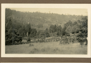
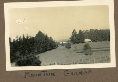 Mt Dandenong & District Historical Society Inc.
Photograph
The photograph is from the album of Ivy Child. It shows a rare scene of the Mountain Grange Homestead. Mountain Grange was built by Thomas Hand on his 306 acres. By 1881 he had completed the homestead and a large barn. Thomas Hand died suddenly in 1888 and his family took over the property. His son William Hand lived in the homestead until 1931 until it was demolished due to white ants. The great barn was demolished in 1930. A new home was built and Will stayed until 1939 when the property was sold to the Shire of Lillydale. It is now the site of the Kalorama Oval. This photograph is c1927 Ivy May Child (1910 – 1989) was the daughter of Arthur Edward (Ted) Child (1878 – 1964) and Ethel May Madden (1888 – 1970). Ted Child was the son of Matthew Francis Child (1839 – 1933) and Martha Jeeves (1857 – 1926). He was the grandson of one of the early pioneers Francis Child. Ivy grew up on the family property on Childs Road and took many photographs. Most of these are glued into her photo album. The album covered the years from c1927 – 1932. Ivy married Henry William Burgess (1906 – 1968) in 1944. The photographs remain in their original state in the album with individual copies made. Black and white photograph showing a cleared area. There is a wire and posr fence in the foreground, a tall row of pine trees across the centre with two buildings visible. One in front of the trees RHS and he other in a gap in the centre. A crop has been planted in two long rows centre right of the photograph.Handwritten below the photograph in the album: MOUNTAIN GRANGEivy child, mountain grange, thomas hand, william hand, will hand, barn, great barn, homestead, shire of lillydale, kalorama oval -
 Mt Dandenong & District Historical Society Inc.
Photograph, Post Office and 'Mountjoy', Mt. Dandenong North, 1913
... as one tree. The other was planted in 1880. The shop is the shop... tree. The other was planted in 1880. The shop is the shop ...Rose Series post card #182Copy of Rose Series postcard #182 showing Kalorama Gap in 1913. Haystacks in foreground with Mountjoy Guest House and Beulah Tea Rooms/Mt Dandenong North Post Office in centre. This photograph has a detailed inscription on the back handwritten by John Lundy-Clarke in 1974.Kalorama Gap in 1913 The elm trees are in the centre of the picture. One of these is really two as two suckers of the further tree were twisted together by Fred Jeeves in 1898 and grew as one tree. The other was planted in 1880. The shop is the shop of Mrs Eliza Hand and daughter Florence. The closed in far end of the verandah was the Mount Dandenong North Post Office. The large house is “Mountjoy” owned and run by the Jeeves Family from 1908 till 1943. It was built in 1905 by the Paynters who sold to Ellis Jeeves in 1908.He moved his line of coaches from “Kalorama” his old homestead and housed the horses in a line of stables behind “Mountjoy”. Price’s house, which contained their shop, the first one on the mountain, opened 1906, can be seen faintly behind the pine tree opposite the bend in the road, which was the main road then and now is Ridge Road. The Price’s house just shows in two tiny pieces, one on each side of the pine tree half way up. The house to the right of and high up the pine tree is Walker’s cottage which exists today opposite Jack Kidd’s home at the far edge of Lt 2 Village Settlement and was between Main Road and Barbers Road which runs down the left behind the elms. Walker’s homestead can be seen near left edge of picture 2/3 way up. The roof of the Methodist Church shows among trees left of picture. This, like Mrs Hand’s shop was built on portions separated from Isaac Jeeves’ Selection “C” known as Jeeves Saddle. kalorama gap, five ways, mountjoy, john lundy-clarke, beulah tea rooms, post office, fred jeeves, paynter, jeeves, frederick jeeves, price, walker, jack kidd -
 Southern Sherbrooke Historical Society Inc.
Photograph - Photo-colour- Montague apple orchard, 1954
Colour photograph of Bill and Stella Montague's original house with the orchard that was planted in 1952 in the foreground. The home of Alf and Marion Montague (Bill's parents) is on the left. A line on the left side indicates this is two photos stuck together to form a panorama. Trees in orchard appear to be quite young. -
 Southern Sherbrooke Historical Society Inc.
Photograph - Exterior of St Martins Church, Belgrave South
B&W photo of St Martins Anglican Church in its original location on (now) Belgrave-Hallam Rd, Belgrave South. The photo shows the street face of the building with dark-stained timbers. These were probably the original oiled weatherboards which were used in 1928. In front of the church is a wide wire gate and a smaller wired gate, and part of a fence can be seen on the right. There are shrubs planted against the church wall and a noticeboard is attached to the front wall of the sanctuary. The sign says 'St Martins Church of England' but the rest is illegible. Tall trees can be seen behind the building. -
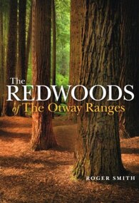 Otway Districts Historical Society
Book, Lothian Custom Publishing, The redwoods of the Otway Ranges. Roger Smith, January 2015
This book is the remarkable story of the world's tallest tree species, the Redwood, growing in the Great Otway National Park in Victoria's south-west. It was originally planted by Victorian foresters for experimental purposes on land abandoned by the early settlers. The Coast Redwood, native of California, is now thrives in the Otways alongside the famous eucalypt, the towering Mountain Ash. The majestic Otway Redwoods, still in their youthful growth phase, have withstood adversity caused by fire, landslide, lighting and chainsaws, while the ongoing political debate about the conservation of the valuable forest resources continues.The redwoods of the Otway Ranges. Roger B. Smith. Lothian Custom Publishing; Middle Park (Vic); 2015. ii, 202 p.; illus., maps, appendices, notes. IBSN 978 1 921737 13 8. Soft cover.With best wishes from Roger Smith. -
 Bendigo Historical Society Inc.
Document - PETER ELLIS COLLECTION: ORDER OF AUSTRALIA
4 page A4 printed document. Achievements of Peter Ellis (for consideration for the Order of Australia) Peter is regarded as one of the leading collectors and presenters of traditional dance tunes, dances and musical instruments in Australia. At the 2005 National Folk Festival it was announced by Robyn Holmes that he has the largest selection of dance related material collected in the National Library Archives in Canberra. Peter has been collecting for many years and has collected with the late John Meredith (AM), Shirley Andrews (AM), Rob Willis and Dave Di Santi amongst others. Peter has literally travelled Australia collecting over the past thirty years. He has extensive field recordings from Western Australia and Tasmania in addition to his Victorian collection, for example. Most of his recording has been in North Western and Central Victoria. Peter collected a lot of his material from Harry McQueen ( Castlemaine), which led to a double CD of Harry's music. Harry had played in dance bands for over sixty years in Central Victoria. Harry had a number of tunes from Bill McGlashan who had taken Harry under his wing as a young man. Through Peter's efforts much valuable material and knowledge from almost a century ago was saved for posterity. Founder, Charter member and life member of the Bush Dance and Music Club of Bendigo. Life Member of the Victorian Folk Music Club. Recipient of the Graham Squance award (for the person who has done the most to promote folk dance and music in Victoria)) from the Folk Song and Dance Society of Victoria. Member of the famous Wedderburn Old Timers Band for over twenty-eight years (two platinum and several gold recordings in that time). Founder and leader of the Emu Creek Bush Band (twenty-nine years old in 2010) Emu Creek has made many CDs of dance music as listed. Friday Night at the Spring Gully Hop, Three double CDs called 'Quadrille Mania' which contain many rare dances and tunes which have been learnt and recorded, under Peter's guidance, so they would not be lost to posterity. A triple CD called 'Take Me Back To Bendigo' with heritage songs and music from the Gold Rush to Federation (solely organised and financed by Peter) These CDs show the multicultural heritage in Bendigo and include music and groups from the Koorie, Chinese, Cornish, German, Irish, Italian, Scots, English and Welsh communities of Bendigo and district. Upon his recovery of costs Peter has handed over copyright to the Bendigo Community so future profits go back into the community. Three double CDs called 'The Merry Country Dance' with dances and tunes going back to the time of Governor Lachlan Macquarie's Ball in 1804. Most of the tracks are performed by Emu Creek Following much practice under Peter's tutelage. For further authenticity Peter liaised with other musicians to record some tracks which were revived from almost two hundred years ago and have now been recorded using the instruments of the time. A three volume set of Bush Concert recordings (Vol 1 Goornong (launched Australia Day 2006 with any profits going to the Soldier's Memorial Hall Committee), Vol 2 Heywood and Vol 3 Maldon/Sutton Grange, already recorded and to be released as money from other projects becomes available. NOTE: None of these CDs have led to any profit. All money raised is put back into the community and further heritage recordings, books and videos through the Bush Dance and Music Club of Bendigo Inc. In 2009 a full collection of all Peter's book and CDs was donated to the John Gorton Library as part of the recognition of the fifty year career of the Gay Charmers Dance Band from Lake Charm. 'Music of the Diggings' (4 tracks by Peter or Emu Creek). In addition the Emu Creek Band, under Peter's leadership, has appeared on a CD backing Bruce Watson on his song, 'The Old Bush Dance'. Emu Creek has performed at National Folk Festivals in four states and several times at the National Folk Festival in Canberra. They have also been mainstays of the Maldon Folk Festival for over twenty years as well as doing dance programs for the Port Fairy Folk Festival on two occasions. Peter has written and published many books related to traditional music and dance. These include Three volumes of 'Collectors Choice' which is musical notation for bush dances coupled with much dance history which would have been lost without Peter's efforts. 'Two Hundred Dancing Years - How to run a Colonial Ball: (co-authored with Shirley Andrews (A.M.), 'Music Makes Me Smile - The Music of the Nariel Valley' (co-authored with Harry Gardner). The Merry Country Dance' (292 pages) a companion to the three double CDs. He has also been a contributor to Verandah Music' authors Rob Willis and Graham Seal and 'The Oxford Companion to Australia Folklore' Ed Graham Seal. Peter is also a regular contributor to 'Trad and Now' Magazine. His latest completed book is titled 'The Merry Country Dance' and is over three hundred pages of social history, recipes and dance instructions. It was completed with the assistance of a Victorian Government Heritage Grant. The first edition sold out in only a few weeks. Peter has taught many children about old time musicianship through the junior bands which have functioned over the years with many children joining Emu Creek and then going on to follow their own musical inclinations. He has trained several young concertina and button accordion players over the years. Peter has been a regular tutor with Continuing Education in tin whistle, harmonica and old time dancing for many years. Peter has conducted workshops in music dance at National Folk Festivals in Perth, Alice Springs, Maleny, Melbourne, Adelaide, Kuranda and more recently at several Canberra National folk Festivals. He has also done this at Maldon for many years, Port Fairy, Glen Innes, Jamberoo and Kiama Festivals. For over thirty years Peter has been a guest player and MC for the dances at the Nariel Folk Festival (Australia's oldest continuing Folk Festival) Peter is very well known in the Corryong area as a collector and the co-author of the book, Music Makes Me Smile, about the Klippel/Simpson dynasty in the Nariel Creek Band. This book is currently being revised for re-issue as more material has come to light since the original publication. For many years Peter trained Debutante Sets in the Bendigo District. Peter was an instigator of the annual Dinki Di Ball held each September in Eaglehawk for the past thirteen years. At this ball three bands play for a quarter of the night and then join together for the final part of the evening. The bands are Emu Creek, The Wedderburn Old Timers and the Gay Charmers. Up to four hundred dancers, many in heritage costumes have attended this dance. The ball also pays tribute to, and involves, the old MC's. Through this example their skills have been passed down to a younger generation of MC's. All profits are returned to the Dance Club to foster our musical heritage. Each Ball includes presentations designed to promote social dancing in Australia. Over the years several young musicians have been presented with musical instruments at the Ball, libraries have been given copies of Peter's books and CDs and one year a keen young dancer was presented a pair of dancing shoes. Peter is a trained ballroom dancer and has gained gold medal status in this field. Peter is an accomplished musician and is one of Australia's foremost button accordion players. He is also highly accomplished on the tin whistle, bones and harmonica. He is the only exponent of the Swanee whistle that I have seen. Peter also plays the piano and ukulele. Thirty six years membership of the Bendigo Field Naturalists Club, Secretary in the 1970s and actively involved in campaigns to save Lake Pedder and establish the Whipstick and Kamarooka State Parks (now part of the Bendigo National Park). Peter was also extremely active in the establishment of the Salomon's Gully and Jackass Flat Flora Reserves in Bendigo which have now been saved for posterity. Peter has also been involved in efforts to save One Tree Hill and this area has now been included in the Greater Bendigo National Park. He has discovered and named new plant species in the Whipstick Forest and propagates Australian plants. Peter takes regular guided tours of interested people through the Whipstick each Spring on wild flower educational tours. He is a keen and gifted photographer of local plant species. Life member of the Bendigo Field Naturalists. Peter contributed text and photographs to their publication 'Wildflowers of Bendigo'. When the Victorian State Parliament had its first historical sitting outside Melbourne Emu Creek played during lunch for the guests and public. They have also played at functions such as the Centenaries of Federation, the Bendigo Post Office, the Shamrock Hotel and the opening of the new Melbourne Museum and the Federation Museum in Bendigo. The band regularly plays for Seniors week and at homes for the aged such as Bethlehem, Mirridong, Bignold Park, Bendigo Village and others. Peter has been instrumental in getting the band to play for fundraisers such as schools, scouts and environmental groups. The band plays many charitable 'gigs'. The band supports the Bendigo Easter Fair and the Eaglehawk Fair when able and has appeared in several parades over the years. The above list shows the invaluable contribution that Peter Ellis has made towards the collecting and distributing of Australia's musical and dance heritage. No one has done more than Peter in this area. He has also been active locally and nationally in his endeavours towads saving the natural environment. He has put many years of time and energy into both area's and has many on going projects in mind for the years ahead. The awarding of an honour from Australia would be just reward for a man who has preserved so much of our musical and dance heritage for future generations. Knowing Peter I have no doubt he would treasure such an honour as he has given so much to preserve Australia's music and dance heritage over most of his sixty plus years. Compiled by John Williams. Handwritten notes at bottom of last page reads: Referees Jacinta Allan MLA Steve Gibbons MHR Willie Carney ex Mayor of Bendigo Supporting letter Mary Smith Sec. Bush Dance + Music Club.person, individual, peter ellis oam -
 Bendigo Historical Society Inc.
Photograph - HILDA HILL COLLECTION: BLACK AND WHITE PHOTOS, 1921-1922
Series of Black & White Images of Hill Family in the years 1921-1922. Total 7 Photos. Darkie the horse tethered to stable. Zita, Nora, Rita & Doreen one Zita is dressed in black with white scarf around her neck and wearing a dark coloured hat, other three are all dressed in white Nora has a dark hat and other two have broad brimmed hats, Rita and Doreen have black ribbons hanging from their necks, to the right are a man and lady seated on the ground and in dark clothing, a man with a pipe in his mouth and wearing a grey suit and hat in background, lady in black and lady in white looking in other directions, background has grandstand with gab le roof and fronted by a white picket fence and people sitting at tables and chairs, trees in right background, Queenscliff February 1921. Rita Nora Doreen lying face down on the beach, girl on left has dark hat on, background shows large shed and other housing with fences, 'Merry Mermaids' Queenscliff 1921.Four girls and one male, three girls dressed in white, one in dark colour, two have light coloured hats and two have dark colour hats, one girl dressed in dark colour, male is wearing white trousers and college coat with stripes, background shows skyline of the nearby city and beach buildings, two men occupy a seat right back ground and dressed in dark clothing, Queenscliff 1921. Cyril Fred Mollie Doreen in a conga line the boys in grey suits and the girls in white, one has circular bands on her skirt, hedge in near back ground, gable roofed building and trees further back,'Durvol' January 1922. Hal wearing dark coat and jodhpurs long boots sitting astride a bicycle, something balanced between the handlebars and on the top bar, paling fence with vine hanging overhead other plants in the corner of the yard, December 24 1921. Doreen riding in a billy cart and pulled by a large dog along a pathway, Doreen is wearing all white, background is bushes and hedge with large tree, Dog is dark colour, 'I'm coming' January 1921.Hilda Hill Personal Collectionaustralia, history, post war life -
 Bendigo Historical Society Inc.
Document - PETER ELLIS COLLECTION: PETER ELLIS EULOGY
2 A4 sheets. Handwritten pencil note at top of first page reads: Eulogy published in Trad & Now Magazine. Vale Peter Ellis OAM. By John Williams. The folk community lost a giant on May 18th when Peter Ellis passed away after a short illness. Peter had been a collector, author and musician for nearly forty years and his work has been prodigious to say the least. Peter has the largest collection of dance related material in the National Library and had travelled Australia on his collection trips. He produced twenty CDs of dance music and historical music with his Bendigo based band the Celebrated Emu Creek Bush Band which he founded and led for thirty four years. His final project was the double CD 'Cooee, Songs of the ANZACS' which he organised in conjunction with the Bendigo Historical Society. It was launched on 24th April and was Peter's last performance. Peter has also been a member of the Wedderburn Old Timers for over thirty years and has assisted with many of their recordings including their latest Bush Concert CD which Peter Organised. Peter has contributed to many other CDs over the years and has been thanked on many a CD cover by many folk artists. Peter has also written several books, the three volume 'Collectors' Choice,' 'Two Hundred Dancing Years' co-written with Shirley Andrews OAM, and 'Music Makes Me Smile' the history of the Nariel Valley musicians co-written with Harry Gardner. Peter's recent major work The Merry Country Dance will become the bible for people wishing to learn about our bush music heritage with its matching six CD collection. Peter has also contributed to 'Verandah Music' edited by Rob Willis and Graham Seal and 'The Oxford Companion to Australian Folklore' edited by Graham Seal and is a regular contributor to Trad & Now. He completed his last Trad & Now article the week before he died. Peter was also a life member of the Field Naturalists and was extremely active in campaigns to preserve Lake Pedder, the Whipstick Forest and Kamarooka Forest (now part of Bendigo National Park and preserved forever) One Tree Hill, Jackass Flat Flora Reserve and Saloman's Gully bushlands. Peter has discovered and named plants in the whipstick and enjoyed propagating native plants. He loved his amazing bush block in suburban Bendigo. Peter was also a keen photographer and had photos published in the book 'Wildflowers of Bendigo'. Peter taught dancing and music classes with Continuing Education for many years and encouraged many young musicians over the years. Peter was an accomplished ballroom dancer and had achieved gold medal status in that field. He was one of Australia's finest exponents of the button accordion, concertina, harmonica and tin whistle. Peter also played piano, organ and ukulele as well as the Swanee whistle and bones. Peter was the founder of the Annual Dinki Di Ball held each September in Eaglehawk as a tribute to the old MC's. Peter was happy playing for fund-raisers for any organisation who asked and also enjoyed plying the big gigs such as for the opening of the Melbourne Museum or for State Parliament. He played in the National Folk Festivals in four states and was a regular at the National in Canberra where he gave regular classes, performed with his bands and was a stalwart of the Aussie section of the session bar. He performed at nearly every Maldon Folk Festival and was MC at Nariel Folk Festival dances for many years. Peter was very proud of his OAM and wore the little medal at all of his performances. That honour was rightly given to one who did so much to preserve Australia's dance history. Peter lived a full life and was a friend to hundreds of people. He was taken far too young and in typical fashion was planning new projects right till the end. His passing is a huge loss for us all but one thing is certain. He will never be forgotten.person, individual, peter ellis oam -
 Bendigo Historical Society Inc.
Photograph - HILDA HILL COLLECTION: BLACK AND WHITE PHOTOS, 1918-1920
Hilda Hill Collection. Black & White Photos of Hill Family Total 9. Three girls at SHLC 1918 with white sashes and medallions, dark clothing with white collars, background is garden scene , photo has over exposure problem which gives a lighter print, 24 September 1918, could it be a ladies college of education? Al standing wearing white blouse and dark dress holding a white hat standing and Gert sitting and holding a white hat in front of a bush wearing a white blouse and a light coloured skirt, background is forested area, 'The Pines' January 9th 1919. Claire dressed in dark dress and wearing a white hat with her hands together, oval photo, 'The Ranche', October 23 1918. Jonah wearing a hat and white dress with colourful hemline standing before a large hedge holding a parasol, large tree background left, 'The Ranche'. Three boys and two dogs All boys dressed in dark coats and shorts long socks two of the boys are on their haunches, Background is a gabled roof and 2 chimneys, white fence, between two of the boys is a water tap on a medium height pipe, Durvol December 1919. Moll Noonan seated on a round backed chair wearing a white dress, right background shows the side of a building, at knee level sis a broad leafed plant, other shrubbery in the background, 'The Ranche' November 1918. Ettie seated on a staircase and holding a dog, lady is wearing a broad brimmed hat, One Tree Hill April 18 1920. Two ladies in lightly coloured dresses standing in a garden setting, lady on left has a black sash waistband, Durvol December 1919 . Group of seven girls and 4 boys, all of the girls are dressed in white, front girl has black neck accessory, 'The Pines' January 9 1919 No. 7 Reservoir.Hilda Hill Personal Collectionaustralia, history, post war life