Showing 1103 items
matching west side
-
 Charlton Golden Grains Museum Inc
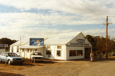
Patton's Garage West Charlton c. 1987
The garage was established in the 1930s by Mr Gamble. Other proprietors were Perc Kimberley 1943-46, Henderson 1946, Neil Rogers. K. & B. Patton ran the garage from 1960s - 2008Colour photo of K. & B. Patton's Garage. The garage is a white, weatherboard single story building with a corrugated iron roof. There small lean-to on the LH side of the building. There is a large entrance and two large windows on the front. There are two petrol pumps at the front of the building. A blue car and a white utility are parked at the LH side of the garage. The signage on the front of the building reads K. & B. PATTON NISSAN and there is a NISSAN sign painted on the roof. There is a sign for Peter Stuyvesant cigarettes on the roof of the lean-to. A telegraph pole and the entrance to Gordon Park is on the right of the photo.perc kimberley, k & b patton, gamble, henderson, neil rogers -
 Port Melbourne Historical & Preservation Society
Photograph - TT Line truck park, Station Pier, Port Melbourne, Lyn Allison, 1993 - 1994
three (3) colour photographs of foreshore Station Pier east side, to create the TTLine truck park. .01 - view West with bulldozer and trucks .02 - "Abel Tasman" with bulldozer in foreground and first row of piles. .03 - view to Port Melbourne across foundations for truck park.piers and wharves - station pier, transport - ferries, abel tasman, harpers starch factory, fox hay timber and hardware pty ltd, london family hotel, band rotunda, tt-line truck park -
Coal Creek Community Park & Museum
Shoes, female, West Brook Masor Pty Ltd
... , with pattern on toe and stitching on sides. Shoes, female West Brook ...Back high heel 'court' style shoe, with pattern on toe and stitching on sides.7C Sipanna by West Brook. Made by West Brook Masor Pty Ltd. Leather sole. -
 Bendigo Historical Society Inc.
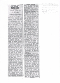
Newspaper - LONG GULLY HISTORY GROUP COLLECTION: CENTENARY MEMORIES - CORNISH EMIGRANTS IN BENDIGO
Copy of a newspaper article titled Centenary Memories, Cornish Emigrants in Bendigo, More Cornish spoken than at St. Just. Written on the side is - This was published in a West Cornwell Newspaper & sent back to Aust in a clipping George Ellis has original. Approx circa 1951. Items mentioned are: More Cornish spoken than at St Just, Best Cornsih Style, Singing Gullies particularly where Cornishmen and Welshmen were as they were fond of singing, Royal visits, St Just point and Open House for Cornish.bendigo, history, long gully history group, the long gully history group - centenary memories - cornsih emigrants in bendigo, bendigo advertiser, mrs kennedy, duke of edinburgh 1867, prince albert victor of wales, prince george (later king george v), edward prince of wales, the duke and duchess of york, french's corner long gully, old cornwall society, mr john ellis, bendigo hospital, mr harry perak malaya, mr and mrs charles harry, mrs boyns, hon mrs j keppel, lord st levan, mr keppel, victorian railways, bendigo railway station, mr herbert thomas -
 Bendigo Historical Society Inc.
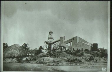
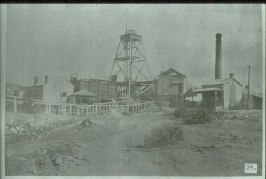
Slide - ALBERT RICHARDSON COLLECTION: CENTRAL NELL GWYNNE GOLD MINE, WEST BENDIGO
Slide. Central Nell Gwynne Gold Mine, West Bendigo. Large mining buildings on RH side of image, poppet head in centre. Buildings have elevated tramways and ore chutes. Mullock heaps on LH side.No. 33 printed on bottom of slidecottage, miners -
 Bendigo Historical Society Inc.
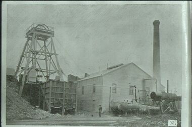
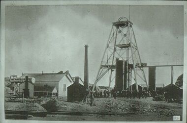
Slide - ALBERT RICHARDSON COLLECTION: HUSTLERS REEF MINE OLD HUSTLERS
Slide. Hustlers Reef Gold Mine, Old Hustlers, south west corner Anderson Street and Prouses Rd. Poppet head on LH side, wooden quartz bins in front. Boilers and compressors outside the engine/boiler room. Man standing centre of image in front of engine room. Photo sourced from 'Healthy Golden Bendigo'No. 32 printed on bottom of slidemine, gold, hustlers reef., bendigo mines-jack hattam collection. -
 Bendigo Historical Society Inc.
Slide - ALBERT RICHARDSON COLLECTION: NEW MOON GOLD MINE, EAGLEHAWK
Slide. .New Moon Gold Mine, Eaglehawk. Mine situated west of Beebzlebub Road, Eaglehawk. Poppet head in centre of image, brick chimney and mine buildings on RH side, ore bins and mine sheds on LH side. Image sourced from 'Healthy, Golden Bendigo' book.No. 25 printed on bottom of slidemine, gold, new moon., bendigo mines-jack hattam collection -
 Bendigo Historical Society Inc.
Slide - ALBERT RICHARDSON COLLECTION: NEW ARGUS GOLD MINE, EAGLEHAWK
Slide. New Argus Gold Mine, Eaglehawk, west of Sailor's Gully Road. Image taken about 1906. Poppet head with elevated tramway, with ore cart on tracks. Engine room and boiler on LH side, brick chimney at rear. Large group of men standing at base of poppet head.No. 23 on bottom of slide.mine, gold, new argus., bendigo mines-jack hattam collection -
 Bendigo Historical Society Inc.
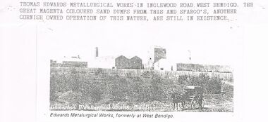
Document - CORNISH COLLECTION: THOMAS EDWARDS AND METALLURGICAL WORKS
Document. Cornish Collection - Thomas Edwards. Two pages from Bendigo and Vicinity's (badly copied with Left Hand side of page not being fully legible in page 247). Biographical details. Reference to his Pyrites Works (in Bendigo and Ballarat) - details of these works. Photo of Thomas Edwards accompanies one page and separate copy of photo shows Edward's Metallurgical Works, West Bendigo (source? / - this photo has typewritten attachment detailing location in Inglewood Road; mention of Spargo's (another Cornish owned operation of this nature).bendigo, gold mining, metallurgical works, thomas edwards. edwards metalurgical works. -
 Monbulk RSL Sub Branch
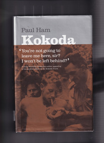
Book, Paul Ham, Kokoda, 2004
For the first time ever, the compelling story of the infamous Kokoda Track campaign has been told from both sides of the conflict. In a unique and balanced portrayal, renowned journalist Paul Ham recounts both the Australian and Japanese perspectives of the events on the hellish Papuan jungle trail where thousands fought and died during World War II. Based on extensive research in Australia and Japan, and including previously unpublished documents, Kokoda intimately relates the stories of ordinary soldiers in 'the world's worst killing field', and examines the role of commanders in sending ill-equipped, unqualified Australian troops into battles that resulted in near 100 per cent casualty rates. It was a war without mercy, fought back and forth along 90 miles (145 km) of river crossings, steep inclines and precipitous descents, with both sides wracked by hunger and disease, and terrified of falling into enemy hands. Defeat was unthinkable: the Australian soldier was fighting for his homeland against an unyielding aggressor; the Japanese ordered to fight to the death in a bid to conquer 'Greater East AsiaIndex, bib, ill, p.602.non-fictionFor the first time ever, the compelling story of the infamous Kokoda Track campaign has been told from both sides of the conflict. In a unique and balanced portrayal, renowned journalist Paul Ham recounts both the Australian and Japanese perspectives of the events on the hellish Papuan jungle trail where thousands fought and died during World War II. Based on extensive research in Australia and Japan, and including previously unpublished documents, Kokoda intimately relates the stories of ordinary soldiers in 'the world's worst killing field', and examines the role of commanders in sending ill-equipped, unqualified Australian troops into battles that resulted in near 100 per cent casualty rates. It was a war without mercy, fought back and forth along 90 miles (145 km) of river crossings, steep inclines and precipitous descents, with both sides wracked by hunger and disease, and terrified of falling into enemy hands. Defeat was unthinkable: the Australian soldier was fighting for his homeland against an unyielding aggressor; the Japanese ordered to fight to the death in a bid to conquer 'Greater East Asiaworld war 1939 – 1945 – campaigns – kokoda, world war 1939-1945 - campaigns - south west pacific -
 Victorian Interpretive Projects Inc.
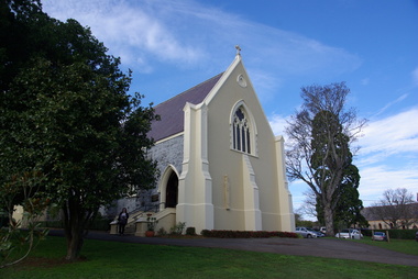
Photograph - colour, Clare Gervasoni, St Peter's Catholic Church, Daylesford, 2015, 14/06/2015
"The fine structure of St. Peter's, with its prettily-decorated interior, which holds crowded congregations at Holy Mass on Sundays, is alone an eloquent testimony of the piety and devotion which permeates the whole parish. Attached to the church is a circulating library, and Catholic papers and other literature are distributed at the church door. Branches of the H.A.C.B. Society and Catholic Federation are doing much good work. (Melbourne Advocate, 17 January 1914) "OPENING AND CONSECRATION OF THE NEW CATHOLIC CHURCH OF ST. PETER’S, DAYLESFORD Cross on St. Peter'sNotwithstanding the inclemency of the weather, the opening of the new Catholic Church of St. Peter’s, yesterday (Sunday), attracted a crowded congregation. Although the rain, which has poured almost incessantly for some days past, had left our roads and streets in the condition for which Daylesford is celebrated in winter weather, and although he storm and rain seemed to increase as the hour announced for the ceremonies approached, the church was filled by a large congregation, comprising all sects and denominations of Christians in and around the district. The beautiful edifice, erected mainly through the zeal, liberality and energy of the respected pastor, presented a most imposing appearance, and reflects infinite credit upon the Rev. Mr. Slattery, and the flock committed to his charge. The church was commenced in November 1863 and has been in the hands of the workmen up to the present time, work being uninterruptedly carried on. On commencing the foundations, it was necessary to excavate until solid clay was reached, which in consequence of the deep rich chocolate soil on the site of the building, had to be carried down to an average depth of 6 feet 6 inches. The foundations were laid with massive stones in courses of 12-inch, and four feet thick, reducing to 3 feet below the floor line. The style of the building is decorated Gothic, and consists of a nave, 80 feet by 30 feet in the clear, and a chancel 18 feet high; from floor line to apex of roof, 47 feet, which is elegantly constructed, consisting of six spans or frames with puncheons resting on carved corbels, low down between the windows. The north side consists of a handsome entrance, near the north-west angle, approached by nine steps of cut stone, and four bays of windows on nave, and a small door on side of chancel, intended as an entry from the sacristy. The south side presents a very handsome view to Victoria street, a beautiful porch entrance giving access to the building on the south-east end of nave; and on the south-west angle a handsome octagonal spire, terminating in an iron cross, with gilt floriations; the height of top of cross, from floor line, is 88 feet. A stone stairs gives access to the organ gallery and the belfry. The whole of the windows are of a handsome geometrical design, and carved in stone, with mullions and tracery, and glazed with amber-tinted glass, the chancel window being 15 feet high, and 8 feet wide. The chancel arch is unusually large, 27 feet St. Peter's interiorhigh and 18 feet wide, and handsomely moulded, and presents a fine appearance from the body of the church. The roof is stained a rich oak, with heavy cornice, and all the walls are smoothly plastered, and colored peach color, giving the amber-tinted glass a beautiful soft cathedral appearance to the interior. The altar is of a very chaste design, the panels being moulded with Gothic heads, and finished in white and gold; the altar rail was not completed, but is intended to be of polished cedar, with carved pillars. The interior fittings will be proceeded with immediately, and to complete the design, an organ gallery, with sittings for about 100 persons besides the choir, will be constructed on the west end. It is intended also to place pillar gaslights on each side of the main entrance, for lighting during vespers in winter. The style of architecture has been strictly carried out, and in the best and most substantial manner. The building has been erected under the superintendence of the architect Mr. John Townsend Brophy, a member of the congregation, and who has discharged his duty with great ability and care. The hour of half-past eleven has scarcely passed when from the sacristy entered His Lordship the Right Rev. Dr. Gould, Bishop of Melbourne, preceded by the Very Rev. Dean Hayes (Sandhurst), the Rev. P. J. Slattery, and a number of boys dressed in white surplices. The Right Reverend Prelate proceeded to the foot of the altar, the Very Rev. the Dean on his right, and the Rev. P. J. Slattery on the left. The prayers usual upon the occasion were read by the Bishop. A procession was then formed, and went around the church in the following order. Several youths bearing wax candles first, next the Very Rev. the Dean, then the Bishop and his train bearers, and following were the Rev. Mr. Slattery and acolytes. Having returned to the altar in the same order, the Deacon (Dean Hayes) and Sub-Deacon (Rev. P. J. Slattery) proceeded to robe his Lordship, who had taken his seat at the epistle side of the altar, for the solemn High Mass, at appropriate times wearing his mitre and bearing his crozier. The mass, which was chanted by the Bishop with touching simplicity and earnestness, was then commenced. The choir, under the direction of Mr. Meunsch, organist, was full and most effective. Mrs. Testar, of Melbourne, having generously offered her valuable services, took the leading soprano solos, and it is scarcely necessary to add, rendered them with exquisite taste and feeling – her beautiful voice being heard with great effect throughout the entire building. The choir consisted of the following ladies and gentlemen who volunteered to aid in the ceremonies upon this most interesting occasion. Ladies: Mrs. Tresar, soprano; Mrs. J.J. McCormick, alto; Miss Julia Conry, soprano; Mrs. Vincent, soprano; Mrs. Aitken, soprano. Gentlemen: H. Guthiel, tenor; Master John Murphy, tenor; James Knox, bass; J. M. Murphy, bass; Mr. Staunton, baritone; Mr. Sourby, alto; Mr. Short, bass. The chant, “Let us adore,” during the procession, was given by Mrs. Vincent with considerable power. The selection of the “Imperial Mass” (Haydn’s No. 3) was felicitous, and the highly artistic and finished manner in which the different parts were sustained, demonstrated that great and persevering care must have been bestowed on the preparation for “the opening day.” The “Kyrie” was given with the full strength and power of the choir. The swelling of the voices in complete harmony, and the pealing of the organ in the midst of incense and prayer, produced a most marked effect upon the congregation. In the “Gloria,” the solos of Mrs. Testar were really beautiful and Mrs. McCormick rendered the alto solos with considerable merit. Mr. Knox sang the part commencing with the words “Qui tolles” with much taste and power. The “Credo” than which we believe there is not a more magnificent piece of sacred music extant, was most successful in its rendering, nor do we ever remember to have heard anything more touching than the manner in which the line “Vetam Venturi in Seculi,” was given by Mrs. Testar. The offertory hymn “Come unto Me all ye that labor,” was given by Mrs. Testar with the most thrilling effect. The “Sanctus” having been sung, in which Mr. Sourby ably rendered an alto solo, the “Agnus Dei” was commenced with a solo by Mrs. McCormick and was given with great taste and feeling, Mrs. Testar, at the conclusion of the “Agnus,” taking up the soprano part. Mass being concluded, the Very Reverend Dean Hayes ascended the altar and proceeded to preach the opening sermon, taking as his text Second Paralipomenon [Chronicles II], 7th chapter and 16th verse – “For I have chosen and have sanctified this place that My hand may be there for ever, and My eyes and My heart may remain there perpetually.” St Peter's manseAt the close of the sermon a collection was made by the very reverend preacher, assisted by John Egan, Esq., Corinella, on behalf of the church, and about fifty pounds were contributed. When it is remembered that 500 tickets had been issues at 10s each, and the inclemency of the weather taken into consideration, the collection may be regarded as a large one. Benediction was sung by the Rev. P. J. Slattery, assisted by Dean Hayes, the choir singing the “O! Salutaris Hostia” and “Laudate.” Handel’s Hallelujah Chorus was sung at the termination of the ceremonies. The vestments issued at Benediction, as well as at the Mass, were of the most gorgeous and beautiful character. When the Benediction was over, the Rev. P. J. Slattery, standing at the front of the altar said– “I wish to say one or two words before the congregation leave. I feel most deeply indebted to all of you who have attended here today for the honor and glory of God, not withstanding the difficulties you had to encounter from this most inclement season. I am truly delighted at such a manifestation of feeling, and will not easily forget it.” The rev. gentleman having disrobed, thanked the members of the choir for their kindness in assisting at the ceremonies, and more especially Mrs. Testar, who had braved all the storm and rain to be present at, and give the advantage of her great musical abilities on, the “opening day.” (Daylesford Mercury, 15 May 1865.)A number of photographs of St Peter's Catholic Church, Daylesford, taken at the 150th anniversary celebration. st peter's catholic church daylesford, decoration, altar decoration, anniversary, daylesford, religion, painting, interior, slattery, gough, d'alton, mcmahon -
 South West Healthcare
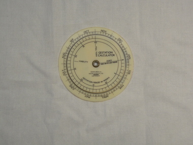
Gestation Calculator, Down Bros & Mayer & Phelps ltd, Medical equipment, 20th Century
Plastic disc with moving inner wheel"GESTATIONAL CALCULATOR" "DOWN BROS and MAYER & PHELPS LTD" "GESTATION PERIOD IN WEEKS" on reverse side; "NESTLE LACTOGEN"pregnancy calender, gestational calculator -
 Dutch Australian Heritage Centre Victoria
Circular Ashtray
Smoking became common in The Netherlands as a result of trade with the West Indies. The Jan Steen illustrations of typical chaotic households were well known and eventually came to be used to poke fun at excessive tidiness.A round pewter ashtray with a scene from a Jan Steen interior in the centre bowl section. 4 cigarette resting places are round the outside edge.The outside edge is decorated with scroll type engravings. A pewter manufacturer's mark is impressed on the reverse side of the bowl. -
 Buninyong & District Historical Society
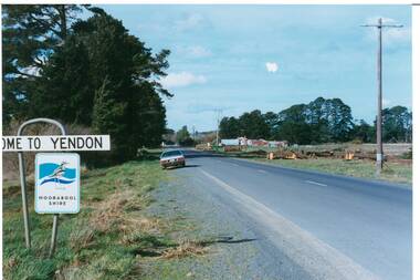
Photograph - Original Photograph, Mr. C.J. Brooks, Main street of Yendon from the West, September 1995
Social, historicalExample of the Moorabool Shire sign and the felling of trees for power company in the late twentieth centuryColour photo, of the Western outskirts of the township of Yendon showing 8-10 felled pine trees of the southern side of avenueroad signs, yendon, moorabool shire, streetscape, felled pinetrees, powercor -
 Buninyong & District Historical Society
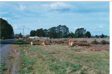
Photograph - Original Photograph, Mr. C.J. Brooks, Main street of Yendon from the West showing felled pine trees, September 1995
Social, historicalExample of the felling of trees for power company in the late twentieth centuryColour photo, of the Western outskirts of the township of Yendon showing 8-10 felled pine trees from the southern side of avenueyendon, moorabool shire, streetscape, felled pinetrees, powercor -
 B-24 Liberator Memorial Restoration Australia Inc
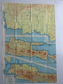
Map - British World War II silk map of Sumatra (South) and Java (Extreme North West), 1944
Silk and rayon maps were produced by Great Britain (some 1.75 million in total), the United States (c.7.5 million) and Australia during World War II. They were issued to Allied military personnel as part of 'escape and evasion' kits.This map, printed on rayon, is an original British 'escape and evasion' kit map from World War II.A multi-coloured, contoured, double-sided map printed on rayon, 1944 Series South West Pacific Area (SWPA) and Asia Sheet G Sumatra (South) and Java (Extreme North West) and, on the reverse, Sheet H Borneo (South West), Java and Sumatra (Extreme South)world war ii, silk maps, great britain, a187 -
 B-24 Liberator Memorial Restoration Australia Inc
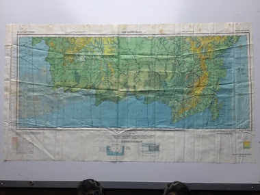
Map - US World War II multi-coloured map, Side 1 - No. C-47 South Borneo, Side 2 - No. C-48 West Java, 1944
Silk and rayon maps were produced by the United States (c. 7.5 million in total), Great Britain (some 1.75 million in total) and Australia during World War II. They were issued to Allied military personnel as part of 'escape and evasion' kits.This map, printed on acetate rayon, is an original US 'escape and evasion' kit map from World War II.A multi-coloured, contoured, double-sided map printed on acetate rayon AAF Cloth Chart Side 1 - No. C-47 South Borneo Side 2 - No. C.48 West Javaunited states of america, silk and rayon maps, world war ii, a191 -
 Wannon Water
Brochure, Cross' patent joint no.14175, circa 1915
Samuel Cross worked for the Hamilton Waterworks Trust and his invention relates to a box joint in two sections and is particularly useful for repairing a pipe containing fluid under either high or low pressure in which a leak, blow out, or burst occurs. Samuel Cross' invention is mentioned in the minutes of the Hamilton Waterworks Trust, copied pages can be found in the supplementary files. Cross' invention helped to prevent water loss whilst a pipe was being repaired. Hamilton Waterworks Trust was an early predecessor to Glenelg Water which later merged with Portland Coast Water and South West Water to form Wannon Water. The patent is significant because the invention was revolutionary for the early Victorian 20th century engineering, and it is still being used today.A3 sheet, printed on both sides, folded into A4, printed in black and white, contains 4 photographs.water pipes, water supply, engineering, samuel cross, hamilton -
 National Vietnam Veterans Museum (NVVM)
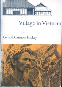
Book, Hickey, Gerald, Village in Vietnam
One of the struggles between East and West is taking place in South Vietnam, an area whose culture has been virtually unknown to scholars. The author has used the small village of Khanh Hau, in the Mekong River delta southwest of Saigon, as a microcosm for the study of the rural physical setting, the beliefs and customs of the several religions that exist here side by side, the kinship and family pattern, the crops and agricultural methods, the economic, administrative, the legal systems, and the socioeconomic structure and mobility.One of the struggles between East and West is taking place in South Vietnam, an area whose culture has been virtually unknown to scholars. The author has used the small village of Khanh Hau, in the Mekong River delta southwest of Saigon, as a microcosm for the study of the rural physical setting, the beliefs and customs of the several religions that exist here side by side, the kinship and family pattern, the crops and agricultural methods, the economic, administrative, the legal systems, and the socioeconomic structure and mobility.ethnology -- vietnam, anthropology, cultural, mekong river, khanh hau -
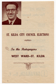 St Kilda Historical Society
Ephemera - Brochure, St Kilda City Council Elections West Ward - St Kilda, 1951
Campaign material for the re-election of Geo E Cavanagh as councillor for the West Ward in the St Kilda City Council elections held on 23 August 1951. It contains a statement by the candidate and polling day details. Geo E Cavanagh was first elected in 1945. He was not re-elected in 1951.Cream paper (discoloured with age) printed in brown on both sides and folded in half.st kilda council, st kilda council elections, geo e cavanagh -
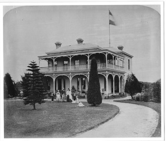 St Kilda Historical Society
Postcard, Brighton Rd (south west)
Photo shows two adults and four children with croquet sticks in hand in front of building black and white photograph, unmounted, copy, good conditionOn back: Brighton Road, w side Built for Emil Thoneman, Merchant. Demolished approx 1960. Flats now on the site in Wimbledon Avenue -
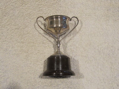 Geelong Cycling Club
Trophy, Cup
This cup was presented by the Geelong West Amateur Cycling Club to the cyclist with the fastest time in 1934. It was donated by the Radford family.Cup won by Eric Radford in a race promoted by the Geelong West Amateur Cycling Club in 1934. The professional Geelong West Cycling Club included an amateur chapter in the middle 1930s at a time when amateurism was flourishing. Eric Radford went on the set up in business in the cycle trade in Elizabeth street Geelong West until the middle 1970s.Silver cup with a handle to each side. The cup has milled edges and the base in brown bakelite or plastic."G.W.A.C.C. FASTEST TIME 1934/E. RADFORD"geelong cycling club; geelong west cycling club; trophy; cup; e. radford; -
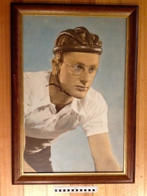 Geelong Cycling Club
Print, Careys Picture Framing Gallery, Circa 1950
Russell Mockridge b1928 d1958 was described 'as the greatest cyclist of all time'. He died during a race in collision with a bus that also claimed the lives of two fellow riders and a spectator. Mockridge started in 1946 by winning his first race of 40km with the Geelong Amateur Cycling Club. His wins soon earned him the nickname of the Geelong Flyer. He represented Australia at the London Olympic Games in 1948 and the Helsinki Games in 1952. He also represented Australia in the 1950 British Empire Games in Auckland where he took gold in the 1000 sprint and the 1000m time trial and silver in the 4000m pursuit. In Paris 1952 he won the Amateur Grand Prix and the following day the Open Grand Prix, beating world professional champion Reg Harris. Later that year he won Manchester Wheelers Club Muratti Cup again beating Reg Harris. He turned professional a year later and teamed with Sid Patterson and Roger Arnold to win the Paris 6 day race in 1955. Mockridge was one of 60 of 150 entrants to finish the 1955 Tour de France. He won 12 consecutive Australian championships. Mockridge was married and had a daughter, Melinda (1955)Russell Mockridge was described 'as the greatest cyclist of all time'. He achieved international notoriety as a cyclist from the mid 1940s until his death in 1958, representing Australia in the Olympic games, the Commonwealth Games, The Tour de France and other international high profile cycling events.Framed print of Russell Mockridge in cycling attire. Head and shoulders depiction. Mockeridge is wearing a leather cycling helmut and white cycling shirt typical of cycling gear of that era. The frame is wooden with gold mount and has a wire hanger on the reverse side.geelong cycling club; geelong amateur cycling club; geelong west cycling club; geelong flyer; russell mockridge; olympic games; tour de france; -
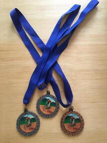
 Geelong Cycling Club
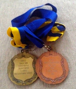
Medal
Medals were presented by the Geelong West Cycling Club until the year 2002. Medals have always been given as recognition of achievement in competitive events.Medal in bronze metal conglomerate. The front of the medal depicts an olive wreath around the circumference, and has a racing cyclist painted on an enamel disk in the centre. On the reverse side, an inscription of the winner of the Men's Pursuit Track Championships for 2002 appears inside an olive wreath decoration. The medal has a blue ribbon attached to it. "GWCC/Track Championships/Pursuit/Men/Jeric Strong/2002"gwcc; track championships; jeric strong; -
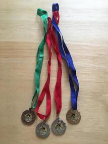
 Geelong Cycling Club
Medals, 1998
Medals were presented up until the year 2002 at the Geelong West Cycling Club.Medals are a recognition of achievement in competitive cycling events.2 x Medals - one in bronze metal conglomerate, the other in gold metal conglomerate. The front of the medals depict an olive wreath around the circumference, and has a racing cyclist painted on an enamel disk in the centre. On the reverse sides, inscriptions appear inside an olive wreath decoration. Each medal has a ribbon attached to it.Medal 1 - "GWCC/Track Championships/Time Trial/Men/Jeric Strong/2002" Medal 2 - "GWCC/Track 1998/Steve Kestle/Trophy Series/C Grade/Encouragement Award"gwcc; track championships; time trial; jeric strong; track; steve kestle; -
 Geelong Cycling Club
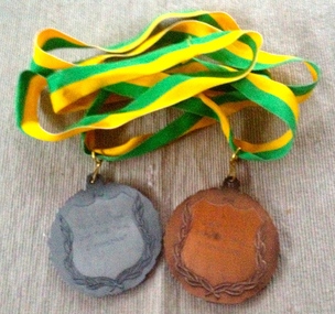
Medals, 1994
Medals were presented up until the year 2002 at the Geelong West Cycling Club. Medals are a recognition of achievement in competitive cycling events.2 x Medals - one in bronze metal conglomerate, the other in silver metal conglomerate. The front of the medals depict an olive wreath around the circumference, and has a racing cyclist painted on an enamel disk in the centre. On the reverse sides, inscriptions appear inside an olive wreath decoration. Each medal has a green and yellow ribbon attached to it. Medal 1 - "GWCC 1994/Junior Time Trial/Men/D. Marchant" Medal 2 - "GWCC 1994/Junior Time Trial/G. Spaulding"medals, gwcc, jnr time trial, d marchant -
 Geelong Cycling Club
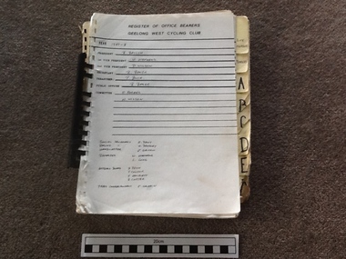
Record Book
Contains details of memberships between the years 1987-1995 - some of which are incomplete.Provides a record of office bearers and members during this period of time.Spiral bound booklet A4 size containing a register of members. The loose leaf sheets are bound together with a spiral plastic binder. There are index tabs along the right hand side of the book. There is no hard cover attached.geelong west cycling club; register of office bearers; 1987-95; members; -
 Geelong Cycling Club
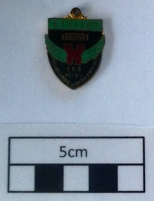
Medallion, 1951
Awarded to participant L Stephenson of GWCC in 1951 on completion of the Melbourne to Warrnambool Road Race.L Stephenson is recorded from the late 1920s to 1951 and beyond as a successful racing cyclist with the GACC and GWCC. Awards of such medallions reflects the recognition given to the competitors of the Melbourne-Warrnambool road race over 163 Miles.Small enamelled medallion. It has a black background with green wings coming from a red centre figure. There are inscriptions on the black background and on a green header at the top of the badge. There are also inscriptions on the reverse side of the badge."Healing 1951 Melbourne-Warrnambool 163 Miles" "Jubilee Year 10/KC Luke Melbourne"geelong west cycling club; l stephenson; melbourne warrnambool road race; medallion; 1951; -
 Geelong Cycling Club
Medals, 2002
Medals were presented by the Geelong West Cycling Club until the year 2002.Medals have always been given as recognition of achievement in competitive events.Medals in bronze and silver metal conglomerate. The front depicts an olive wreath around the circumference, and has a racing cyclist painted on an enamel disk in the centre. On the reverse side, inscription of the winner of the Women's Track Championships for 2002 appears inside an olive wreath decoration. "GWCC/Track Championships/Scratch Race/Women/Yolanda Russell/2002/Sprints/Time Trial"gwcc; track championships; scratch race; women; yolanda russell; 2002; sprints; time trial; -
 Geelong Cycling Club
Medals, 1998
Medals were presented by the Geelong West Cycling Club until the year 2002. Medals have always been given as recognition of achievement in competitive events.Medals in bronze and gold coloured metal conglomerate. The front of the medals depict an olive wreath around the circumference, and has a racing cyclist painted on the disks in the centre. On the reverse side are inscriptions with the purpose of the race and the year. "GWCC/Barry Hoppen Memorial/1998"gwcc; barry hoppen memorial; 1998;