Showing 1409 items
matching william golding
-
 Bendigo Military Museum
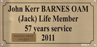
Plaque - RECOGNITION PLAQUES 2011, C.2011
These 3 plaques were originally placed on 3 doors within the Soldiers Memorial Institute building in Pall Mall Bendigo in recognition of the years of service as volunteers to the Bendigo RSL Sub Branch & Bendigo District RSL Sub Branch in 2011. Over time the small plaques were added regarding their ongoing volunteer years and passing. During the renovations to the Soldiers Memorial Institute & Museum which closed in 2016 all plaques were taken down that were in the building. These 3 were not put back in the original positions. .1) John Kerr Barnes OAM, refer Cat No 8040 for his volunteer service. .2) John Edward Fay, refer Cat No 8129P for his volunteer service. .3) William James Norman Smart, refer Cat No 8131.2P for his volunteer service..1) Plaque, metal, front face gold colour, all text and edging in black, one small gold plaque placed on the bottom RH corner. .2) Plaque, metal, front face gold colour, all text and edging in black, 3 small gold colour plaques have been added. .3) Plaque, metal, front face gold colour, all text and edging in black, 2 small gold colour plaques have been added.brsl, smirsl, plaque, recognition, volunteer -
 Bendigo Military Museum
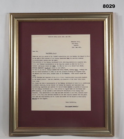
Letter - RECCOMENDATION FOR LIFE MEMBERSHIP 1954, Sir George Lansell Bendigo RSL, 13.5.1954
Willam John Turner. The recommendation details his awards of being made a Life Govenor twice, Fund raising for the POW efforts, RSL Relief fund, RSL Picnic Committee, Chairman & Organizer off, RSL Inter Units Social Club, President and Treasurer off and Committee. The originals of this submission are damaged and will be in later Cat No’s in the Turner collection. Cat No 8030 will detail his service history and more RSL involvement.Framed letter, frame is timber gold colour, frame backing is maroon colour with the letter I set. This is a copy of the letter for the reccomendation for a Life Membership of the RSL to William John Turner Bendigo Sub Branch. The letter is very specific as to the roles and fund raising undertaken by Turner over many years. The fund raising amounts in Pounds is quite large.Letter heading and signed, “Memorial Hall Pall Mall Bendigo 13th May 1954” “Yours faithfully" "Sir George Lansell” Funds raised in Pounds, “£3891 - £4,100 - £2,000 - £938 - £200” The last figure was an annual amount raised.brsl, smirsl, life membership -
 Bendigo Military Museum
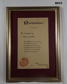
Certificate - CERTIFICATE, PROCLAMATION 1943, C. November 1943
The “Ugly man Contest” was a fund raiser for the P.O.W comfort fund in which £3891 was raised. (Pounds). The certificate was given to William (Bill) John Turner Bendigo RSL Sub Branch. Refer Cat No 8029 re this effort and others by Bill Turner. Refer Cat No 8030 for his RSL history and his WW1 service details.Framed certificate, frame is timber gold colour, backing piec is maroon colour, certificate is a fawn colour, all text in black. At the top is the word “Proclamation” followed by text, a red seal/stamp is at the bottom LH side. The paper relates to the “Ugly man Contest”Text, “Be it known by these presents - Bill Turner on the Tram each day, of ugly men he has his say; In competition he gives us shocks; And with his trams, he has his stops. In this event, he’s worked each day, to do his bit, in this big fray” “Bendigo November 27th 1943”brsl, smirsl, fund raiser -
 Bendigo Military Museum
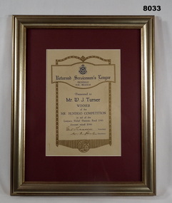
Certificate - CERTIFICATE, MR BENDIGO 1945, Bendigo RSL Sub Branch, C.1945
The Certificate relates to William John Turner Bendigo RSL Sub Branch. Refer Cat No 8029 for details of his fund raising and work with the Sub Branch. Refer Cat No 8030 for details on his Committee history and WW1 service.Framed certificate, frame is timber gold colour, certificate backing is maroon colour, certificate is a cream colour with ornate edging around the details, at the top is the RSL Logo followed by “Returned Servicemen’s League Bendigo Sub Branch” Details of the award follow, signed and dated, all print in blue and black.Main points; “Presented to Mr W.J.Turner - Winner of the Mr Bendigo Competition in aid of the League’s Patriotic fund 1945 - Amount raised £666” “Geo V Lansell President” “W R Porter Secretary”brsl, smirsl, certificate -
 Bendigo Military Museum
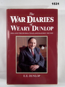
Book - BOOK - AUTOBIOGRAPHY, Sir Edward Dunlop, "THE WAR DIARIES OF WEARY DUNLOP", First published 1986. reprinted 1986, 1987
"THE/ WAR DIARIES/ OF/ WEARY DUNLOP/ JAVA AND THE BURMA - THAILAND RAILWAY 1942 - 1945" Book - item in the collection of Richard William McGILVERY, RAAF. Refer Cat. No. 7287P for his service details, photo, awards, HARD COVER BOOK WITH DUST COVER. Hard cover - cardboard with adhered red buckram, gold print on spine. Dust cover - paper, white print on front, spine and back on red background. Folded flaps with black print on beige background. Illustrated - front - colour seated portrait of Sir Edward Dunlop. Back - copy in colour of watercolour painting of "Weary Dunlop" operating in a jungle hospital by "Jack Chalker". 401 pages - cut, plain, off white paper. Illustrated black and white photographs and sketches.history, books, ww2, autobiography -
 Bendigo Military Museum
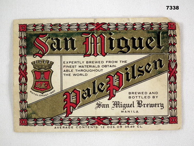
Souvenir - BEER LABEL
San Miguel was a common brand of beer in South East and East Asia, brewed in Manila, Phillipines. Item in the collection of Richard William McGILVERY, RAAF. Refer Cat No. 7287P for his service details, photos and awards.Beer bottle label on white paper. Edging on front is pattern of plants in white and red. Trade name of "San Miguel" across top in red and black on gold background and type of beer in same configuration below. Location of brewery in small black writing and brewery emblem. Measure of contents listed below. A number stamped on back.No. “14272 D” stamped on back.bcof, souvenir, beer, richard william mcgilvery -
 Bendigo Military Museum
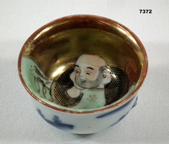
Ceramic - CEREMONIAL BOWL
Small bowl, possibly a finger bowl used for ceremonies. Item in collection of "Richard William McGILVERY" RAAF. Refer Cat No. 7287P for his service details, photos and awards.Small bowl, outside white with blue images of Japanese country side. Inside picture of Asian man sitting on a chair looking at a green cloth covering half of the inside. Other half gold background.Japanese symbol on bottom.bowl, souvenir, richard william mcgilvery -
 Bendigo Military Museum
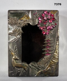
Container - BOX - METAL
Ornamental brass box of unknown use. Item in the collection of "Richard William McGILVERY" RAAF. Refer Cat No. 7287P for his service details, photo and awards.Silver metal box with separate lid. Lid has inlays of Japanese scenery of antelope, tree, buuildings. Mostly gold colour but with red plants. Centre of lid has hole cut into it.ornamental box, bcof -
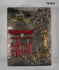 Bendigo Military Museum
Container - CIGARETTE CASE
Souvenirs collected by a member of BCOF in Japan Post WW2. Item in collection of "RICHARD WILLIAM McGILVERY". RAAF. Refer Cat No. 7287P for his service details, photos and awards.Silver heavy metal cigarette box, rectangular shape with curved bowl shape inside. Lid on top has engraved series of Japanese images (Buildings and Deer in gold, gate in red and tree branch in silver). Word - possibly MIYAYIMO engraved into bottom left corner. Inside burnished gold colour.Word - possibly "MIYAYIMO" engraved into bottom left corner.bcof, souvenir -
 Bendigo Military Museum
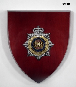
Memorabilia - PLAQUE, ARMY CORPS, LEGA PTY. LTD
Part of the Kevin John Herdman, No. 397661, Collection. See catalogue No. 5942P for details of his service record.Burgundy coloured painted wooden shield shaped plaque with RAASC badge mounted in the middle. Badge has a seven-pointed star topped with a Queen's Crown. Star is overlaid with a brass wreath embossed with the corps' name. Inside the wreath is a blue enamel garter with the corps motto in gold coloured lettering. Within the garter is a royal cypher on a burgundy background. Badge is attached with two small bolts. Facility for hanging on back.Stamped on the back in purple ink: 'LEGA PTY. LTD., 24 WILLIAM STREET, BALACLAVA, VICTORIA, AUSTRALIA'.plaque, unit badge, royal australian army service corps, kevin john herdman -
 Warrnambool and District Historical Society Inc.
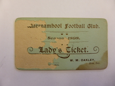
Ticket, Warrnambool Football Club 1898, 1898
This is a lady’s ticket issued by the Warrnambool Football Club in 1898. The Warrnambool Football Club, established in 1861, is one of the oldest clubs in Victoria (and the world?). It merged with South Warrnambool in 1924, was re-established as a stand-alone club in 1928 and joined the Hampden League in 1933. It still competes in this League. The secretary in 1898, William Oakley, was a well-known footballer known as ‘Wing’ and was also a co-Principal with Richard Lawson of a private boy’s school, Warrnambool College, in the late 1890s. This is a significant item as an example of a football club’s lady’s ticket in 1898 and as a 19th century memento from the Warrnambool Football Club and from William Oakley.This is a small cardboard ticket with a green background and gold lettering. The green colouring on the left side has been scratched and removed.‘Warrnambool Football Club, Season 1898, Lady’s Ticket, Warrnambool, W.M.Oakley, Hon. Sec.’warrnambool football club, lady’s ticket, 1898, hampden league, south warrnambool, william oakley -
 Warrnambool and District Historical Society Inc.
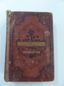
Book, Martin Tattler, 1876
This book, by the well-known author R.M.Ballantyne, was awarded to Edith Newton in 1877 when she was a pupil at the Warrnambool State School. This school was opened on August 1st 1876 when the National School in Warrnambool closed and most of the pupils of other denominational schools in Warrnambool at the time moved to the new State School. The Head Teacher, William Bryant was at the school until 1894. (Blanch) Edith Newton was born in 1868, the eighth child of Robert and Mary Newton. Robert Newton was a Rate Collector, Borough Inspector and Manager of the Town Common in Warrnambool. It is noted that the prize received by Edith Newton was an adventure book mostly appealing to male readers. This book is significant because it is connected with important elements in Warrnambool in 1877 – the school, Warrnambool State School, the pupil, Edith Newton and the Head Teacher, William Bryant,This is a hard cover book of 330 pages. It has a dark red cover with etched ornamental borders and patterns and an image of a jungle scene on the front cover and on the spine. The title and author’s name are in gold lettering. At the heading of each chapter there is an ornamental scroll and there are several black and white sketches throughout the pages. There are blue stamps of the Warrnambool & District Historical Society at the front and back of the book and a school plate label attached to the inside front cover. The spine is partly detached and torn and the cover is very worn and water or mould damaged. A letter from the donor accompanies the book. ‘Warrnambool State School, No. 1743, Prize Awarded to Edith Newton, 4th Class, Divn. 111, for Home Exercises, 19th December 1877, W.Bryant, Head Teacher.’ warrnambool state school, history of warrnambool, william bryant, edith newton -
 Warrnambool and District Historical Society Inc.
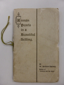
Booklet, Human Pearls in a Beautiful Setting, 1910
This booklet (fourth edition) was written in Warrnambool in 1910 by William Britton Harvey. The book has the sub-title ‘A Study in Nature and Character – Being a Quiet Talk to an Imaginary Audience of Young Men and Young Women’. Born in Britain, William Britton Harvey was the Editor of the Warrnambool Standard newspaper from 1905 to 1919. It was he who initiated in Warrnambool the scheme known as the Annual Hospital Egg Appeal, a community activity that was later adopted by most hospitals in Australia. William Britton Harvey wrote other small books of a similar nature to ‘Human Pearls in a Beautiful Setting’. This book is important because it was written in Warrnambool in 1910 by William Britton Harvey – a prominent person in Warrnambool at the beginning of the 20th century. It is a good example of the type of didactic book written 100 years ago with the purpose of encouraging high moral conduct in the youth of the day. This is a small soft cover booklet of 32 pages. The cover is cream with a woven pattern and the lettering on the front cover is gold. The cover has one gold line separating the name of the book from that of the author and the letter ‘H’ has an ornamental border. The cover overlaps the pages. The pages are a cream colour with blue printing. There are six black and white illustrations. The cover is torn at the edges and there is some silverfish damage on the back cover. The book has been bound with one metal staple and tied with green string. The staple has been removed. william britton harvey, warrnambool standard, history of warrnambool -
 Warrnambool and District Historical Society Inc.
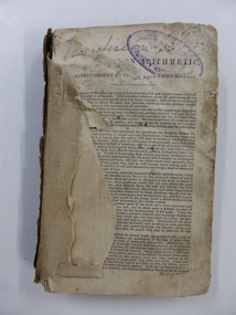
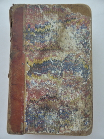
Book, Arithmetic, 1842
This is an early school arithmetic book with the front preface indicating it is the third edition published in 1842. The book appears to have been used about the 1860s by members of the Bell family who probably lived at Cudgee. The names of the children, presumably the Bell children, are scattered throughout the book – Margaret, Walter, Sarah and William. No information is available on this Bell family though there are records of births in Warrnambool of Bell children in the 1850s to William and Jane Bell. Cudgee, a small settlement on the Cudgee Creek, is about 16 kilometres from Warrnambool. This book is of some minor interest because of its age and because it has some association with the Bell family who may have lived at Cudgee in the mid 19th century. The exercises in the book are of interest as examples of the arithmetical problems given to children in the mid 19th century. This is a hard cover book of 282 pages. The cover is dark brown with gold lettering on the spine but the front cover and part of the first few pages are missing. The pages are ragged and dog-eared and quite dirty in places. There is handwritten material in both pencil and ink on the front pages, throughout the text and on the back page. ‘Margaret’ ‘Walter’ ‘Sarah’ ‘William Bell’ ‘Cudgee’ mathematics, bell family, cudgee, warrnambool history -
 Warrnambool and District Historical Society Inc.
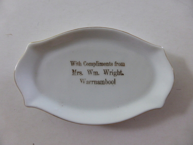
Pin Dish, Mrs Wm Wright Warrnambool, C mid 20th century
Mrs William Wright operated a shop at 95 Liebig street Warrnambool around the turn of the 20th century, where she sold clothing as well as a large range of embroidery and needlework requirement.Some of the work listed in advertisements include shadow work,princess applique and Mount mellick work. She was an experienced and talented needleworker and held classes in a range of work. Mrs Wright advertised that her students had success at local shows in items such as shadow work,, embroidered blouse, best cosy, canvas work, novelty pincushion,floss silk work.Her name was Martha but she always traded under her husband's name. She died in 1952. This dish is a a simple reminder of Mrs Wright This pin dish provides a link with one of Warrnambool's early shopholders and needlewomen. She is featured in a soon to be released publication about women in Warrnambool called Silent Lives. The dish itself is a pleasing little example of a pin dish.Small white plate with gold edging and gold text. It is a rectangular oval shape but all edges are rounded.With compliments Mrs Wm Wright Warrnambool in gold in middle of plate .Made in Czechoslovakiawarrnambool, mrs wm wright, mrs william wright shop, mrs wright liebig st -
 Warrnambool and District Historical Society Inc.
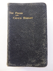
Book, In Psalms & Church Hymnary, 1922
The name ‘Ruttledge’ may have no local significance thought the name ‘Rutledge’ is important in our history, commencing with William Rutledge who purchased the Farnham Special Survey in the 1840s( Tower Hill to Dennington). The name ‘Swinton’ is prominent in our history. Mrs John Swinton (Charlotte Scott nee Dunn, 1871-1944) was married to John Swinton, the son of William and Ann Swinton who came to Warrnambool in 1854. William established a store in Timor Street in the 1850s and opened branches of this store in several local towns. The Swinton family still has commercial interests in Timor Street. This book is of interest because it belonged to Charlotte Swinton, a member of the Swinton family important in Warrnambool’s commercial and community history. This is a black leather-covered book of 656 pages plus a Supplement of Hymns of 32 pages. The cover has gold lettering on the front and the spine. The pages have a gilt edging. The inscriptions are handwritten in pencil. The cover is somewhat scuffed and worn. ‘Mrs John Swinton’ ‘A. Ruttledge, 317 Wattletree Rd., E. Malvern’ swinton family, warrnambool, john swinton, charlotte swinton, history of warrnambool -
 Warrnambool and District Historical Society Inc.
Book, The Child’s Guide to Knowledge, Early 20th century (50th edition)
This book contains information for children on a great variety of topics and is in the form of a catechism with questions and answers. Pearl Davidson would be a member of one of the pioneer Davidson families. The brothers, James, John and William Davidson were early settlers in the Warrnambool district. This book is of antiquarian interest as an early instructional guide for children. It is also of interest because it belonged to a member of the Davidson family, important early settlers in the Warrnambool area. This is a hard cover book of 474 pages. The cover is a mottled brown with gold lettering on the spine. The binding is much worn and partly torn away. The inscription is handwritten in black ink. ‘Pearl Davidson’pearl davidson, the child's guide to knowledge -
 Warrnambool and District Historical Society Inc.
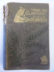
Book, Glimpses of South America, 1882
This book was given as a Sunday School prize to James Cassady. The donor was William Wines. The Wines families were pioneers in the Woodford district. James Cassady was the son of William and Elizabeth Cassady and the family lived at Boughton on the Merri River (near Cassady’s Bridge, Caramut Road today). This property was established about 1845. Charley and Joe, whose names have also been written in the book, were James’ brothers. This book is of interest because it belonged to James Cassady, the son of pioneer settlers in Cassadys’ Bridge/Woodford area. This is a hard cover book of 220 pages with 32 extra pages at the back of the book giving information on other books produced by the same publisher. The cover is grey-green with gold lettering, green and black floral decorations and gold images of two men on horseback and a South American Indian chief. The spine is torn away at the top and the cover and pages are stained and crumpled. There are many black and white illustrations throughout the text, with the frontispiece protected by a piece of tissue. The inscriptions are handwritten in black ink and pencil.‘Woodford Sunday School presented to James Cassidy (sic) by his well-wisher William Wines’ (this is re-written underneath in pencil with the correct spelling of ‘Cassady’) ‘Chaley cassady, boughton, merri river (sic) “Joe’ james cassady,, boughton, william wines, woodford sunday school, history of warrnambool -
 Warrnambool and District Historical Society Inc.
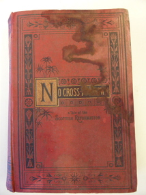
Book, No cross no crown
This book has been given by the Woodford Sunday School to Edith Cassady (note the misspelling of ‘Cassady’). Edith Cassady was the daughter of William and Elizabeth who lived at Boughton on the Merri River (near Cassady’s Bridge, Caramut Road today). This property was established about 1845. The donor of the book was William Wines, a member of a pioneering family in the Woodford district. This book is of some interest as it belonged to Edith Cassady, a member of a pioneering family who lived at Boughton on the Merri River. This is a hard cover book of 344 pages. The cover is red with black border decorations and black and gold lettering. There are several full page black and white illustrations scattered throughout the book which has 23 chapters of story. The cover and pages are much water-stained. The inscription is handwritten in black ink. ‘Woodford Sunday School Presented to Edith Cassidy (sic) by her well-wisher William Wines’ william wines, woodford, history of woodford, edith cassady, boughton property, cassady family -
 Warrnambool and District Historical Society Inc.
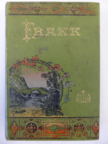
Book, Frank, Late 19th century
This book was given as a prize in 1892 to Joseph Cassady from the Cassady’s Bridge State School. This school, once located near Cassady’s Bridge on the present-day Caramut Road, was opened on 19th January 1891 and closed in December 1892. The first teacher was Janet Ada McDougall and the teacher when the school closed was J. H. Delahenty. The Cassady family had the farm, Boughton and this was established about 1845 on the Merri River near where the bridge is today. Joseph was born in 1882 to William and Elizabeth Cassady.This book is of considerable importance as it is the only memento we have of Cassady’s Bridge State School. This school only existed for two years.This is a hard cover book of 208 pages. The cover is green with coloured borders and a coloured sketch of a stream and a bridge. The lettering on the front cover and the spine is gold and the pages are gilt-edged. The cover is much faded. Some of the back pages are partly torn away. The book has two black and white sketches at the front of the book and 28 chapters of story. The inscription is handwritten in black ink and the inscription page is stained. ‘State School Cassady’s Bridge Xmas 1892 Presented to Joseph Cassady 3rd Class for Good Progress. J.H. Delahenty Head Teacher’ cassady family, boughton, history of warrnambool -
 Warrnambool and District Historical Society Inc.
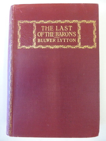
Book, The last of the Barons, 1843
The Davidson brothers, James and John, were pioneer settlers in the Warrnambool district, with John establishing th property of Rosebrook in Woodford and James establishing the homestead of Woodend in West Warrnambool. Another brother William was an early storekeeper in Woolsthorpe. He died in 1904 and may be the W. Davidson who was the recipient of this book. The Midgleys came to the Yangery Creek area in 1852 and established the property of Yangery Grange. Mrs Midgley presumably belonged to one of these families from pioneer times. Ethel Davidson would be a descendant of one of the Davidson families but there were several women with this name born in the 19th century though one born to a William Davidson in 1887 may be the later owner of this book. This book is of interest because of its connection to members of the Davidson families – pioneer settlers in the Warrnambool area.This is a hard cover book of 461 pages. The cover is dark red with some ornamental borders and gold lettering. The book has two black and white full page illustrations, with the first one protected with tissue paper. The inscriptions are handwritten in blue and black ink. ‘To W. Davidson from Mrs Midgley’ ‘Ethel M. Davidson’ william davidson, ethel davidson, history of warrnambool. -
 Warrnambool and District Historical Society Inc.
Book, The Domestic liturgy & family chaplain, 1846
This book belonged to John Cowtan. He was a purchaser of land near Cassady’s Bridge in Warrnambool and an important and early settler in Port Fairy. The land that John Cowtan selected was bought by Williaam Cassady whose sister, Ann, was married to John Cowtan. Cassady established the property, Boughton where Cassady’s Bridge is today. This book came from a Cassady estate sale early in the 21st century. Between 1839 and 1844 John Cowtan was a ship’s captain for John Griffiths, a shipowner and entrepreneur. In 1844 Cowtan established a merchant trading and produce business in Port Fairy with John Bland. In the 1860 John Cowtan went to live in Melbourne.This book is of great interest because of its early date (one year after the founding of Warrnambool) and because of its association with John Cowtan, a pioneer settler of Port Fairy with connections to Warrnambool.This is a brown leather cover book of 385 pages. The spine has gold lettering. The binding has come apart and has been mended with white cotton material on the inside of the cover. The insides of the cover have a brown, white, blue and yellow mottled pattern. The cover is stained and torn at the edges and has a deep gouging on the front. The first page has been torn and mended with tape and some of the pages are stained. There are two pressed fern fronds, one loose newspaper cutting and a bookmark with a sepia-coloured image, lace paper edges and coloured embroidery contained within the pages. The book has a preface and 58 chapters. The inscription is handwritten in black ink. ‘J. Cowtan 1848’ john cowtan, port fairy history, william cassady -
 Warrnambool and District Historical Society Inc.
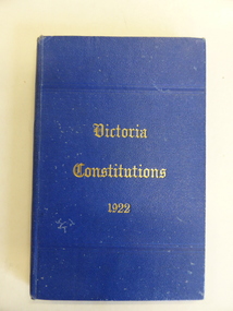
Book, Constitutions of the United Grand Lodge of the Ancient, 1922
This book contains the Constitutions of the Freemason Lodges in Victoria. Freemasonry is a world-wide benefit society. Moves were made in the 1860s to establish a Masonic Lodge in Warrnambool with the first Lodge being St. John’s (No. 895). The Masonic Hall in Kepler Street was built in 1870. This book belonged to a member of the Flaxman family and John Flaxman was a prominent Warrnambool resident in the 19th century – an insurance agent and moneylender in the 1860 and 70s and an employee of the auctioneer, Samuel Macgregor. The book, however, seems to belong to a W. Flaxman. John Flaxman had a brother William but, as far as can be ascertained, he did not live in Warrnambool. There is nothing known so far to link this book with Warrnaambool but it is kept because of the name ‘Flaxman’ and so it may have some relevance.This is hard cover book of 142 pages. The cover is blue with gold lettering on the front cover. The cover is slightly marked. The inscription on the first page is handwritten in black ink. ‘Br W.S.B.J.Flaxman 24-2-25’ william flaxman, freemasonry in warrnambool -
 Warrnambool and District Historical Society Inc.
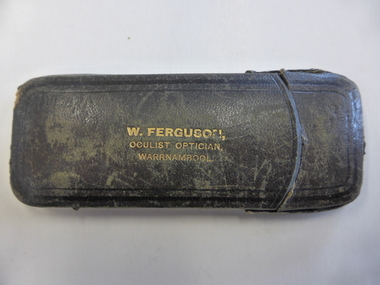
Case, Glasses Case, Early 20th century
This item was supplied by William Ferguson, a jeweller, watchmaker and optician in Timor Street, Warrnambool in the early part of the 20th century. He was Mayor of Warrnambool in 1901-2. It is not known to whom the spectacles belonged. This item has no specific provenance but it is of importance as an example of the type of object supplied by William Ferguson, a prominent businessman in Warrnambool in the early 1900s. This is a spectacles case made of stiffened leather with a leather handle at the top that slides back to allow the case to be opened. The top of the case lifts up to allow the spectacles to be removed. The case has the name of the supplier (W.Ferguson) stamped in gold print on the side. The case is much scuffed and the leather is worn in places. It is empty.‘W. Ferguson, Oculist, Optician, Warrnambool’spectacles case, william ferguson, jeweller and oculist., warrnambool -
 Warrnambool and District Historical Society Inc.
Book, The complete poetical works of William Cowper, Mid 19th century
This book belonged to a Marian Adams from Limerick but, unfortunately no information has been found on this person or the connection to Warrnambool. There were several families in the Warrnambool area with the name ‘Adams’ in the 19th century. This book is kept as an interesting 19th century book but it will be of greater interest if information is found on Marian Adams. This is a hard cover book of 516 pages. The cover is brown leather with gold embossed ornamentation and gold lettering on the spine. The pages are gilt-edged and the cover has become partly detached from the binding. The pages are much stained and the cover is very rubbed. The inscription is handwritten in black ink. There are eight engravings on steel in black and white and all are protected with white tissue. There has been a book plate pasted onto the inside of the front cover but it has been torn away. ‘Marian Adams Limerick, October 19th 1870’ marian adams, history of warrnambool, william cowper poet -
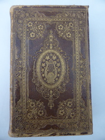
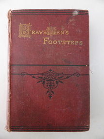 Warrnambool and District Historical Society Inc.
Book, Brave Mens footsteps 1873, 1873
This book was given as a school prize to Walter Wright by the Wangoom School in 1873. The name ‘Wangoon’ is on the printed book plate – is this a misprint or an alternative spelling of ‘Wangoom’? Wangoom State School, No. 645, on the Warrnambool/Wangoom Road was opened in 1865 as a Common School. The school is now closed. The Hon. William Bayles, a Melbourne businessman with property near Macarthur, first became a member of the Legislative Council for Villiers and Heytesbury in 1864 and continued until 1880. He was a prominent and popular politician in Warrnambool, regularly giving prizes to pupils of schools in his electorate and in 1872 he offered a £10 prize for the best student in the district. No specific information has been found on Walter Wright or any family named Wright residing in the Wangoom area. There was a piano tuner named W. Wright in the Warrnambool area in the 1870s. Was this Walter’s father? This book is of interest because of the connection with Wangoom School, the Hon. William Bayles and Walter Wright. More interest will be created if information comes to light on water Wright. This is a hard cover book of 333 pages plus 32 pages of advertisements for books published by Henry S. King and Co. The cover is dark red with an ornamental pattern in black on the front cover and lettering in gold on the front cover and spine. The book has three full page black and white illustrations with the illustration next to the first page missing. There is a printed book plate pasted onto the inside of the front cover with blue printing and ornamentation and a handwritten name and date. The cover is partly detached from the binding and the cover and pages are somewhat stained and the cover is frayed. ‘State School, No. 645 Wangoon (sic), Class 3rd, Prize Presented to Walter Wright by the Hon. William Bayles, M.P. for Villiers and Heytesbury, Christmas 1873’. wangoom state school, walter wright -
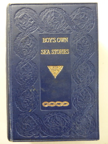 Warrnambool and District Historical Society Inc.
Book, Boy's own sea stories, Early 20th century
This book of sea stories belonged to C. Simpson of ‘Elm Bank’, Wangoom. Charles Simpson was a farmer at Wangoom in the 1860s. The township of Wangoom is about ten kilometres from Warrnambool. Charles Simpson was the brother of George Simpson of Nullawarre and William Simpson who had a drapery store in Warrnambool. The owner of the book would be a descendant of one of these early settlers. This book is of interest as it belonged to a member of the Simpson families, several of whom were early settlers in the Warrnambool district. This is a hard cover book of 424 pages. The cover is dark blue with gold lettering and gold scroll work. The book has a preface, 42 chapters of sea stories and, at the back of the book, several pages of advertisements for other books published by Ward, Lock and Co. There are many black and white sketches scattered throughout the text. The inscriptions are handwritten in black ink. ‘C. Simpson, Elm Bank, Wangoom’ (3 entries) simpson families of 19th century, warrnambool and district -
 Warrnambool and District Historical Society Inc.
Plate, Dinner Plate, Early 19th century
The only information available on this plate is what is written on the base. No other information has been found on Mrs Playford or Thomas and Mary Annerley. Perhaps the plate came to into the collection of the Warrnambool and District Historical Society via the old Warrnambool Museum. The plate has no known local provenance and is kept because of its age and interesting monogram. This is a circular-shaped china plate (probably a dinner plate) with a fluted edge. The edging of the plate has red and gold ornamentation with garlands of flowers in green, pink, mauve and orange. There are four posies of flowers around the bowl of the plate in the same colouring with the addition of blue. In the centre of the plate is a large gold monogram – ‘T.M.A.’ On the base of the plate is a piece of paper partly torn off giving some details of the history of the plate in handwriting. This paper is pasted on to the base of the plate obscuring any maker’s mark that there may be. The plate has been broken into four pieces and stuck together again using five metal clips. There are some chips around the edge of the plate. Monogram: ‘T.M.A.’ ) (Thomas and Mary Annerley) Note on base: ‘… … the property of Mrs Playford of … St. Brighton (and formerly belonged to her great grandmother). Mrs Playford died in her 91st year and left it with some other pieces of the service to William Rodgers of Wellington St., St. Kilda. Monogram, T.M.A, Thomas & Mary Annerley. Copy of signed statement, 1909’ mrs playford, thomas and mary annerley -
 Warrnambool and District Historical Society Inc.
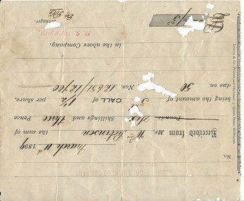
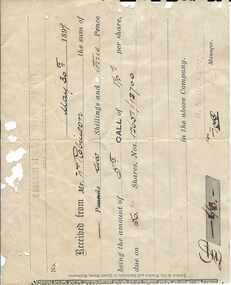
Document, Receipt March 11 1899, 1898
... . The gold-bearing quartz reefs were discovered in 1885 and worked ...Grassmere is a small hamlet about 12 kilometres from Warrnambool. It is a farming area. The Grassmere Gold Mining Company, presumably established by local people in Grassmere, was created in 1898 for the purpose of acquiring from Messrs James and Mewha a lease of a Cassilis gold mine (23 acres). £5000 was to be raised in shares of five shillings and one shilling each. The Manager of the Company was Horatio Dickson of Melbourne and the brokers were McMeekin and Co. of Melbourne and Warrnambool and Dickson and Osborne of Melbourne. This reef mine was one of several in Cassilis, Gippsland, 12 kilometres north west of Swifts Creek. The gold-bearing quartz reefs were discovered in 1885 and worked to 1914. It is not known whether the Grassmere Cassilis mine was a financial success but the mining operations were impeded by the hardness of the stone in the area. William Robinson was a farmer in the Grasmere district. This receipt is of considerable interest as one of only three items the Warrnambool and District Historical Society has that is connected to the Grassmere Gold Mining Company. The gold mine establishment was one of the minor events in the district in the 1890s. This is a buff-coloured 1899 receipt for William Robinson who has paid six shillings and threepence for part payment of his shares in the Grassmere Gold Mining Company. The receipt has black printing and black-ink handwriting. There is one stamp of the Manager ‘H.S. Dickson’ and another of ‘Grassmere Gold Mining Company No Liability’. The receipt has several holes caused by silver fish damage. ‘March 11th 1899, Received from Mr Wm. Robinson the sum of six shillings and threepence being the amount of 3rd call of 1½ per share due on 50 shares nos. 12651/12700 in the above Company, H.S.Dickson, Manager’ grassmere, grassmere gold mining company, william robinson -
 Warrnambool and District Historical Society Inc.
Financial record - Receipt: Grassmere Gold Mining Company, 1898
... in the 1890s. Grassmere Grassmere Gold Mining Company William Robinson ...Grassmere is a small hamlet about 12 kilometres from Warrnambool. It is a farming area. The Grassmere Gold Mining Company, presumably established by local people in Grassmere, was created in 1898 for the purpose of acquiring from Messrs James and Mewha a lease of a Cassilis gold mine (23 acres). The Manager of the Company was Horatio Dickson of Melbourne and the brokers were McMeekin and Co. of Melbourne and Warrnambool and Dickson and Osborne of Melbourne. This reef mine was one of several in Cassilis, Gippsland, 12 kilometres north west of Swifts Creek. The gold-bearing quartz reefs were discovered in 1885 and worked to 1914. It is not known whether the Grassmere Cassilis mine was a financial success but the mining operations were impeded by the hardness of the stone in the area. William Robinson was a farmer in the Grasmere area. This receipt is of considerable interest as one of only three items the Warrnambool and District Historical Society that is connected to the establishment of the Grassmere Gold Mining Company. The gold mine establishment was one of the many minor events in the district in the 1890s. This is an 1899 receipt for William Robinson upon payment of six shillings and three pence, being part payment for shares in the Grassmere Gold Mining Company. The buff-coloured paper has black printing and black-ink handwriting. There are two stamps – one is the stamp of ‘H.S.Dickson’ and the other is the stamp of the ‘Grassmere Gold Mining Company, No Liability’. The certificate has silver fish damage at the top and the right-hand side‘May 30th 1899, Received from Mr Wm. Robinson the sum of six shillings and three pence, being the amount of 5th call of 1½ per share, due on 50 shares, nos. 12651/12700 in the above company, H.S. Dickson, Manager’grassmere, grassmere gold mining company, william robinson, warrnambool