Showing 13711 items
matching wye-river-bridge
-
 Federation University Historical Collection
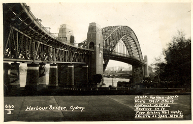
Postcard, Kodak, Sydney Harbour Bridge, c1949, 13/10/1949
Postcard written by Frank Wright to a friend, W. Snelling in London. Frank Wright was a renown resident of Smeaton, where he was born. He lived at Laura Villa, and attended Smeaton State School. His father William was a gold miner and his mother's name was Sarah. Their family won many singing and instrumental awards. Frank was tutored by Percy Code and was awarded a gold medal for the highest marks in the ALCM examinations in the British Colonies at the age of seventeen years. He became the Australian Open Cornet Champion by the age of eighteen. A year later, Frank conducted the City of Ballarat Band, and later the Ballarat Soldiers’ Memorial Band. He formed the Frank Wright Frisco Band and Frank Wright and his Coliseum Orchestra. These bands won many South Street awards, and Frank as conductor won many awards in the Australian Band Championship contest. In 1933 Frank Wright sailed to England to conduct the famous St Hilda’s Band and was later appointed Musical Director of the London County Council, where he organized many amazing concerts in parks, in and around the London district. He was made Professor of Brass and Military Band Scoring and conducted at the Guildhall of Music and Drama. Frank was often invited to adjudicate Brass Band Championships around Europe, in Australia, including South Street and in New Zealand. The Frank Wright Medal at the Royal South Street competition is awarded to an individual recognized as making an outstanding contribution to brass music in Australia.Black and white photograph of the Sydney Harbour Bridge. A small section of the city and water can be seen beneath the arched span of the bridge.Written in white on front - 660.B, Harbour Bridge, Sydney., Height-Top arch - 437 ft.,Width 159 ft. 11 3/4 in., Footways 10 ft. ea., Roadway 57 ft., Four Electric Rail Tracks., Length of span 1650 ft. Handwritten on back - Message to W. Snelling in London from Frank Wrightfrank wright, cornet, conductor, sydney harbour bridge -
 Ballarat Heritage Services
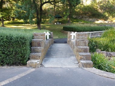
Photograph - Photograph - Colour, The Edna Walling Bridge at Locarno Spring in the Hepburn Springs Reserve, 2020, 12/12/2020
The Hepburn Springs Progress Association invited Edna Walling the the Hepburn Springs Reserve, and sandstone paths and bridges resulted. In 1934 there was a proposal to spend 2,000 to 3,000 poinds at the Hepburn Springs Reserve, with a govenrment loan suggested. Colour photograph of the stone bridge at Locarno Spring in the Hepburn Springs Reserve.hepburn springs, locarno, mineral water, hepburn springs reserve, locarno spring, edna walling -
 Phillip Island and District Historical Society Inc.
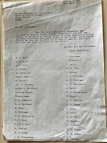
Document, Petition for bridge between Phillip Island and San Remo 1937
On 29 November 1940, a suspension bridge opened between San Remo on the mainland and with Newhaven on Phillip Island. The 540 metre bridge had two lanes but no footpaths, instead having six pedestrian refuges. The main span was 168 metres long. The cables had previously been used on a bridge on Sydney's North Shore. Because of weight restrictions, tourist coaches had to offload their passengers. [Wikipedia]HistoricalFoolscap size photocopy of a petition to Shire of Phillip Island for a bridge to Phillip Island in 1937. Signed by 42 local residents and ratepayers.first phillip island bridge to san remo, phillip island suspension bridge, petition, odlum, ockleford, regos, mcguigan, west, mcfee, richardson, underdown, mcmaster, cleeland, neely, leeson, saunders, scott, brown, hislop, donnellan, rackham, findlay, anderson -
![The Boulders on the Erskine River / [by] Nicholas Caire, circa 1876](/media/collectors/550653872162f11fb04854aa/items/5783420cd0cdd1176c6a3ffd/item-media/57834272d0cdd1176c6ac3f1/item-fit-380x285.jpg) Kew Historical Society Inc
Kew Historical Society IncPhotograph, Anglo-Australasian Photographic Company, The Boulders on the Erskine River, c. 1876
Nicholas Caire was born on Guernsey in the Channel Islands in 1837. He arrived in Adelaide with his parents in about 1860. In 1867, following photographic journeys in Gippsland, he opened a studio in Adelaide. From 1870 to 1876 he lived and worked in Talbot in Central Victoria. In 1876 he purchased T. F. Chuck's studios in the Royal Arcade Melbourne. In 1885, following the introduction of dry plate photography, he began a series of landscape series, which were commercially successful. As a photographer, he travelled extensively through Victoria, photographing places few of his contemporaries had previously seen. He died in 1918. Reference: Jack Cato, 'Caire, Nicholas John (1837–1918)', Australian Dictionary of Biography.An original, rare photograph from the series 'Views of Victoria: General Series' by the photographer, Nicholas Caire (1837-1918). The 60 photographs that comprise the series were issued c. 1876 and reinforced a neo-Romantic view of the Australian landscape to which a growing nationalist movement would respond. Nicholas Caire was active as a photographer in Australia from 1858 until his death in 1918. His vision of the Australian bush and pioneer life had a counterpart in the works of Henry Lawson and other nationalist poets, authors and painters.‘The boulders on the Erskine River’ : Views of Victoria (General Series) No.58 : Albumen silver photograph | Photo on card with Title and Description on reverse | Mounted 24 x 30 cm; Photo 12 x 17 cm.On Reverse: ‘For a distance of several miles this river runs its course over a granite bed, and is interrupted frequently by immense Boulders, which causes the stream to be broken up into rivulets, pools, rapids, falls, cataracts, &c. Many of these massive blocks of granite weigh from 40 to 50 tons. In the mid-distance of the present illustration, several of these great blocks can be seen obstructing the river in its course.’nicholas caire (1837-1918), erskine river, lorne (vic), landscape photography - victoria -
 Wodonga & District Historical Society Inc
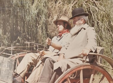
Album - Ringer's River by Des Martin - Plate 1 - Sean O'Day, Horse Breaker at "Gooloora" discusses his future
On a summer's day in 1891 Sean O'Day, Horse Breaker on James MacLough's "Gooloora" Station, is driving the Scots pastoralist in to the railhead at Overton after his annual inspection of that property. Silent and mature for his age, Sean was born in a dray while it was crossing the river during a flood, and has remained at home in it. Because he is always moving by dawn he is known in the borderland as Daylight O'Day. When MacLough asks him what he will be doing on the morrow O'Day replies that he will be manager. Questioned, he suggests that MacLough realises the background to his joke in that the station hands will, that night, celebrate the passing of the Boss's inspection. As they will have hangovers tomorrow all the work will naturally fall to himself, a teetotaller. MacLough nods assent, but, instead of leaving on the train, books a room for the night and a livery gig for the morrow, and drives himself to Gooloora early next morning. D.J. Martin as O'Day, H.S. Diffey as MacLough.The album and images are significant because they document literature written by a prominent member of the Wodonga community. The presentation of this precis was supported by several significant district families and individuals.Ringer's River Album Coloured photo Plate 1des martin, many a mile, ringer's river, northeast victoria stories -
 Glenelg Shire Council Cultural Collection
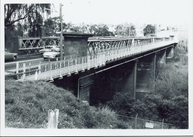
Photograph - Photograph - Killara Bridge over Glenelg River, c. 1963
Sourced from Casterton Town Hall (former Shire of Glenelg)Black and white photo. View of Killara Bridge over Glenelg RiverFront: Black stamp - 003635 Back: 'View of Killara Bridge over Glenelg River' - handwritten in pencil. Blue biro line arrowed both ends, drawn across width of photo. 3" in blue biro written above line -
 Kew Historical Society Inc
Photograph - Chandler Highway Bridge, 1977
The heritage listed Fairfield Bridge was originally constructed for the Outer Circle Railway to bridge the Yarra River between East Kew and Fairfield stations. In the 1930s it was converted for vehicular traffic. In the 2010s a new concrete bridge was erected beside it to increase vehicular capacity.Print copy of the Chandler Highway Bridge, [formerly the Fairfield Viaduct of the Outer Circle Railway] showing the original position of the walkway beside the bridge. The POV is from the Fairfield side looking towards Kew. CHANDLER HWY BRIDGE OVER YARRA / OCTOBER 1977 / ORIGINALLY BUILT FOR OUTER CIRCLE RWYchandler highway bridge, outer circle railway viaduct, bridges -- kew (vic.) -
 Charlton Golden Grains Museum Inc
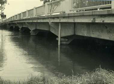
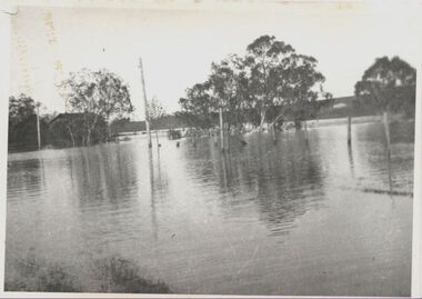
Photograph, Cameron, Ian, 1973 February Flood, Feb 1973
1973 flood. High water depth under Paterson Bridge, Charlton Victoria,B/W photograph of 1973 flood. High water depth under Paterson Bridge.flood, james paterson bridge, charlton -
 Marysville & District Historical Society
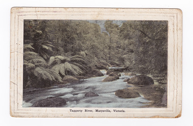
Postcard (item) - Colour tinted postcard, Renwick, Pride & Nuttall, Taggerty River, Marysville, Victoria, 1916
An early colour tinted photograph of the Taggerty River in Marysville in Victoria.An early colour tinted photograph of the Taggerty River in Marysville in Victoria.Australian Enamellers. Country Series No. 3. Produced in Australia To Ms Marlene./ To wish you/ well; & To assist in/ making you as comfy/ as possible. I hope you/ are keeping well & fit/ & that it wont be long/ before you are on your/ way back to Aust. I/ suppose you have heard/ that Jack is on his/ way home, we are/ looking forward to/ the day when he arrives./ My best wishes to you/ & kind regards/ Sincerely yr/ friend/ Raell Dennistaggerty river, marysville, victoria, postcard, souvenir -
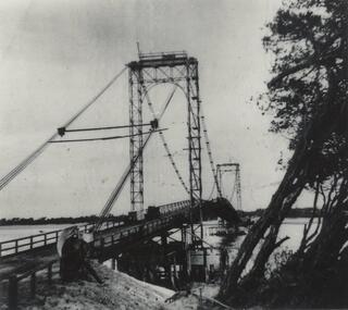
 Phillip Island and District Historical Society Inc.
Photograph, Suspension Bridge, 1939-1940
Phillip Island's first Bridge for vehicular traffic under construction. Phillip Island Suspension Bridge under construction - angled view taken from San Remo with small boat at middle leftlocal history, photographs, civil engineering, bridges, phillip island - suspension bridge, black & white photograph, jack jenner collection, phillip island bridges, public construction -
 St Arnaud and District Historical Society
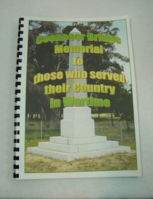
Book. Coonooer Bridge Memorial, Coonooer Bridge Memorial to those who served their Country in Wartime
Following the Great War of 1914-18 the people who lived in the general area around Coonooer Bridge , (18 kms from St.Arnaud ) erected a Monument in honour of those men and women who served their country in a time of war. In 1920 the monument was erected across from the hall, situated in a small pine plantation which was also planted by community members. The names of those that served their country during war time were placed on the monument. After the 2nd World War the names of the local men and women who once again were asked to serve their country were added to the memorial to honour and remember the sacrifice that they made.This book was compiled to honour and enable families and future generations to remember those who served.This is the only book listing these servicemen that served from the Coonooer Bridge Area.Spiral plastic bound book.Clear perspex cover. Coloured pages.Includes photographs of servicemen, medals and war service information.Dedicated to the people of Coonooer Bridge. -
 Kew Historical Society Inc
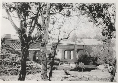
Photograph, Chandler Highway Bridge, 1930s
The railway viaduct linking the Outer Circle railway from Kew to Fairfield was constructed in the 1890s. In the 1930s it was converted into a motorway bridge.Photocopy of a photograph of the bridge linking Kew and Fairfield. Dated to the 1930s following the construction off the Chanler Highway.outer circle railway, viaduct (kew fairfield), john monash, chandler highway bridge -
 Kew Historical Society Inc
Photograph, Willsmere Bridge, 1934
Several boathouses were built in Kew and Fairfield in the late 19th and early 20th centuries. They included Chipperfield’s ‘Moorings’ and floating pontoon. The substantial two-storey house was named the Moorings, and incorporated an upper storey residence. The Moorings was almost washed away in the 1916 floods, and in 1934 almost totally submerged when the Yarra River rose 26 feet in 14 hours. Following the 1934 flood, the house was restored. The floating pontoon, sometimes referred to as a ‘kiosk’ or ‘canteen’, was used to store canoes. Both were removed in 1972 for the construction of the Eastern Freeway.This work forms part of the collection assembled by the historian Dorothy Rogers, that was donated to the Kew Historical Society by her son John Rogers in 2015. The manuscripts, photographs, maps, and documents were sourced by her from both family and local collections or produced as references for her print publications. Many were directly used by Rogers in writing ‘Lovely Old Homes of Kew’ (1961) and 'A History of Kew' (1973), or the numerous articles on local history that she produced for suburban newspapers. Most of the photographs in the collection include detailed annotations in her hand. The Rogers Collection provides a comprehensive insight into the working habits of a historian in the 1960s and 1970s. Together it forms the largest privately-donated collection within the archives of the Kew Historical Society.A view of flooded areas in North Kew in the flood of 1934.Willsmere Bridge. Chipperfields. 1934 floodwillsmere, flood, yarra flood, chipperfields, chipperfields boathouse, north kew -
 Phillip Island and District Historical Society Inc.
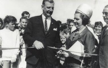
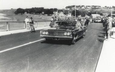
Photograph, Phillip Island Bridge Opening, 1969
Official Opening of 2nd Bridge, 1969, connecting San Remo and Newhaven. From the Jack Jenner Collection.Close up of Hon. Porter & Mrs Porter cutting ribbon at Opening of Bridge. Children & other spectators in background.local history, photographs, civil engineering, bridges, opening of phillip island bridge, black & white photograph, jack jenner collection, phillip island bridges, public construction -
 Mt Dandenong & District Historical Society Inc.
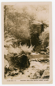
Photograph, Sassafras Creek Near Crescent Bridge. Victoria
Rose Series post card # P. 90. Sassafras Creek near The Crescent Bridge. View of water and ferns. Post 1920.Rose Series sepia coloured post card showing a small creek running through the centre of the photo edged by rocks and tree ferns.On front: The Rose Series, P. 90. SASSAFRAS CREEK NEAR CRESCENT BRIDGE. VICTORIA.sassafras creek, crescent bridge, creek, bridge, tree ferns, rose series, post card -
 Marysville & District Historical Society
Photograph (item) - Colour photograph, 15-05-2008
A colour photograph of the wooden bridge crossing the Taggerty River. A colour photograph of the wooden bridge crossing the Taggerty River. 2008 05 15taggerty river, wooden bridge -
 Orbost & District Historical Society
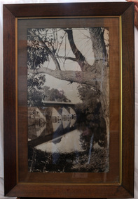
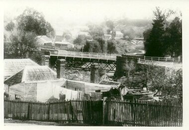
black and white photograph, first half 20th century
This is a bridge across the Snowy River at Orbost. This bridge was built in the 1920s as a road and rail bridge, and was partly washed away by flood waters in 1934. After the end of the first World War the Victorian Railways considered an extension of the railhead across the river at Orbost, and in 1922 a new timber and steel girder structure, a joint Country Roads Board — Victorian Railways venture, was built and completed at a cost of £41,000 (the steel girders came from the Flinders Street viaduct reconstruction). Subsequently it was decided not to take the railway across the river, and the bridge has only been used by road traffic.This is a pictorial record of an early bridge across the Snowy River at Orbost.A very large black / white photograph under glass in a timber frame. It is of a bridge across a river and is framed by trees.bridge snowy-river-bridge road-transport-orbost -
 Cockatoo History & Heritage Group
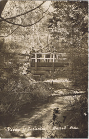
Postcard, Barratt Photo of Men on McBride St Bridge Cockatoo
An early Barratt photo of the Cockatoo Creek, looking towards the McBride St bridge. The four men depicted in the image, look relaxed and are taking in the serenity of the creek below.Dear Florrie, just a card to let you know I haven't quite ? altogether am up here among the ferns and ? It is a lovely place for a quiet holiday the fern gullys are just lovely you can see the Ranges in the distance as blue as the sea. This view is the bridge over Cockatoo creek near the R. Station. As space is short I will close Best Love from ?Original Barratt Photo, of four men standing on the McBride St bridge over the Cockatoo CreekRear of the postcard includes handwritten correspondence in ink, to someone called Florriea. t barratt, postcard, cockatoo creek, cockatoo, views of cockatoo, -
 Phillip Island and District Historical Society Inc.
Photograph, Suspension Bridge, 1939-40
Phillip Island Suspension Bridge under construction - completed in 1940Phillip Island Suspension Bridge taken from shore on angle - Phillip Island side - trees pushed onto right hand side.local history, photographs, civil engineering, bridges, phillip island suspension bridge, black & white photograph, jack jenner collection, phillip island bridges -
 Eltham District Historical Society Inc
Photograph, Para Road Bridge construction, Briar Hill, near Greensborough, c.1971, 1971c
Three black and white photographs; two showing construction works of the bridge over the Plenty River at Briar Hill and one of Greensborough Park, Grimshaw Street, summer 1971-1972greensborough, briar hill, para road, bridges, construction, plenty river -
 Phillip Island and District Historical Society Inc.
Photograph, Phillip Island Bridge Opening, 1969
First traffic across 2nd Bridge, 1969, between Sand Remo & Newhaven, after official opening ceremony. From the Jack Jenner Collection.Minister's Car driving across newly opened Bridge between San Remo & Phillip Island 1969.local history, photographs, civil engineering, bridges, opening of phillip island bridge, black & white photograph, jack jenner collection, phillip island bridges, public construction -
 Greensborough Historical Society
Photograph - Digital image, Plenty River in Flood 2017: Graffiti, 14/12/2017
Photograph of graffiti on the Plenty River bridge, Greensborough. This flood was in December 2017.Digital copy of colour photograph.plenty river, floods, graffiti -
 Marysville & District Historical Society
Photograph (Item) - Black and white photograph, Bridge Over The Cumberland, c1900
An early black and white photograph of a bridge over the Cumberland Creek near Marysville in Victoria.An early black and white photograph of a bridge over the Cumberland Creek near Marysville in Victoria. The Cumberland Creek is in the Cumberland Valley near Cambarville which was a timber town near Marysville. Cambarville is notable for its giant mountain ash (Eucalyptus regnans) trees within the Cumberland Memorial Scenic Reserve, and relics from former sawmills and gold mining. The Big Culvert is located nearby on the Marysville - Woods Point Road, which was historically part of the Yarra Track. Cambarville was established as a timber mill town in the 1940s. Timber mill owners A Cameron and FJ Barton named Cambarville. They established the mill to salvage timber from trees destroyed in the 1939 bushfires. Cambarville was impacted by the 2009 Black Saturday bushfires and any remaining structures were destroyed.ARMSTRONG COLLECTION 42 STATION STREET/ SANDRINGHAM 3191/ TEL. (03) 9521 5442/ IAN M.L. ARMSTRONG OAMcumberland creek, marysville, victoria, cumberland valley, cambarville, mountain ash, eucalyptus regnans, cumberland memorial reserve, the big culvert, marysville-wood's point road, yarra track, a cameron, fj barton, 2009 black saturday bushfires -
 Kew Historical Society Inc
Map, MMBW, River Yarra Beautification Schemes, c.1913
The Melbourne and Metropolitan Board of Works (MMBW) was established by an act of the Victorian Parliament in 1890 to prepare for and to implement a sewerage and water reticulation system across what was then inner Melbourne, its surrounding and middle distance suburbs, including Kew. The MMBW was disbanded in 1991.The map collection of the Kew Historical Society has at its core the historic maps assembled and originally stored in the City Engineer's Department of the City of Kew. These include maps in a number of scales. The vast majority of maps were produced by the MMBW in the first two decades of the twentieth century, and are solid working maps, backed by linen for durability. These maps are historically significant to Kew, the City of Boroondara and to the history of the development of state utilities in Victoria. A number of the Kew maps have additional details added by former municipal officers, including the levels reached by various floods. As these were working documents, information was added to them long after the period of their initial production and distribution.Map of the City of Kew showing part of the River Yarra Beautification Schemes. The map shows development to date and the flood levels reached in 1923 and 1924. This map may have been adapted from an earlier map, as most development in central Kew and Studley Park had occurred by this date yet numerous streets are not represented. Public buildings and institutions are clearly represented and named on the map as are significant public transport infrastructure (eg the Outer Circle railway).MELBOURNE AND METROPOLITAN BOARD OF WORKS / RIVER YARRA BEAUTIFICATION SCHEMES / SCHEME / SCALE 10 CHAINS TO AN INCHmelbourne & metropolitan board of works, mmbw maps, mmbw plans, city of kew, flood levels -- kew (vic.), cartography -
 Stawell Historical Society Inc
Book, P. Van Diesen, Tobacco Growing in Dadswells Bridge, 1991
History Option H.3.C. Tobacco Industry at Dadwells Bridge Contains various photographs.Clear Plastic cover with dark blue edge. on Plastic History Option P. Van Diesen. On Paper underneath cover Tobacco Growing in Dadswell Bridgestawell farming -
 Clunes Museum
Photograph
PHOTOGRAPH TAKEN LOOKING DOWNSTREAM TULLAROOP CREEK, ABOUT 1900. GOVERNMENT BRIDGE IN FOREGROUND, JULILEE BRIDGE IN MIDDLE DISTANCE, PORT PHILLIP MINE POPPET HED IN DISTANCE..1 ORIGINAL PHOTOGRAPH OF GOVERNMENT BRIDGE AND JUBILEE BRIDGE. TAKEN FROM CREEK PARADE. THE GOVERNMENT BRIDGE WAS BUILT CIRCA 1900. .2 ENLARGED PHOTOCOPY IN HANDWRITING : LOOKING DOWN-STREAM TULLAROOP CREEKABOUT 1900 GOVERMENT BRIDGE IN FOREGROUND JUBILEE BRIDGE IN THE MIDDLEbridges, jubilee bridge, goverment bridge -
 Orbost & District Historical Society
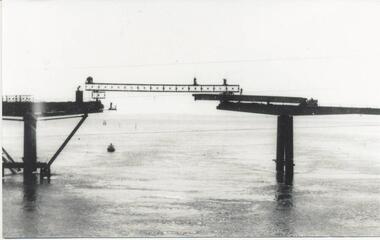
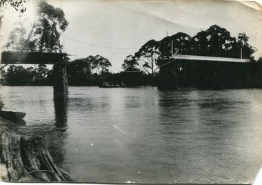
black and white photograph, January 1934
Damage estimated at £500,000 was caused by the 1934 floods in the Orbost district. This 1934 flood was devastating, destroying a section of the 1922 Orbost bridge, wrecking fences, bridges and roads, dumping silt and debris on the rich river flats and drowning cattle. The centre span of the Orbost Bridge was washed away. This item is a pictorial record of the 1934 floods, a significant part of Orbost's history.A black / white photograph showing the flood damage to the Snowy River Bridge. There is a gap in the bridge where the centre span has been washed away. In the background is a punt.orbost-floods-1934 natural-disasters-floods snowy-river-bridge