Showing 22336 items matching "parks "
-
 Ballarat Tramway Museum
Album - Photo Album, Ron Scholton, "661", c1989
A photo album, spiral bound with 10 cardboard sheets with photos of late Alf Twentyman cable car set on covers. Each sheet coated with a glue and overlain by a plastic sheet. Album contains 34 photos of BTM W3 661operating in Melbourne 1989 on a charter for Yapper Tours. - no date on photos. Photos taken at Preston depot, South Melbourne loop, Camberwell depot, Thornbury depot, Preston Workshop gates, Sth Melb. depot, Victoria Parade, St Kilda, Brunswick depot, Victoria Market and Kew depot. Also six photos of W1 427 at Kooyong and Dandenong Roads, St Kilda, Batman Avenue, Swan St. bridge, Hawthorn and Wattle Park. See also Reg Item 5986 for a larger more formal album of photographs. Sample of images added 19-12-2016trams, tramways, w3 class, melbourne, w1 class, yapper tours -
 Ballarat Tramway Museum
Photograph - Black & White Photograph/s, Victorian Railways (VR), c1940
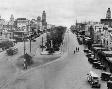
Yields information about the lower end of Sturt St from the Grenville St intersection show a mid 1940's view - shows types of vehicles, shops and streetscape.Black and white photograph of Sturt St. in the mid 1940's looking from the top of a building in Grenville St. towards the West. Has a number of parked vehicles in kerbs, two people riding horses, a Vacuum Oil Co. truck in the bottom right hand corner and an SEC tram travelling west, just past the City Loop points. Colour photocopy, laminated, of this photograph on display 4/2000 at 02-02-06. Colour postcard of same photograph see Reg Item 2981 and another print see Reg Item 4284. Copy 2 - added 30/7/2007, ex Alan Bradley collection of photographs, to depot 5/2007. State Library of Victoria has negative, VR Collection, Series 2716, Photo Number 842961. See also Reg Item 8329 for a better print. Which shows more detail.trams, tramways, ballarat, sturt st., vr photos, tram 20 -
 Ballarat Tramway Museum
Book, G. McEldowney, "100 years of Melbourne's Trams", Nov. 1985
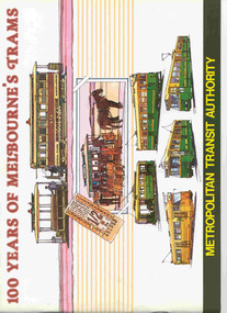
Thirty Two page book, A4 landscape format, saddle stapled, titled "100 years of Melbourne's Trams", published by the Metropolitan Transit Authority and the Australian Tramway and Motor Omnibus Employees Association in 1985. Colour cover featuring drawings of Melbourne trams from cable trams to articulated electric trams. Has foreword by Tom Roper, Minister for Transport. Book published to celebrate the centenary of the opening of the first cable tram in Melbourne, 11/11/1885. Reviews the history of trams in Melbourne, cable trams, horse trams, Clapp, municipal tramways, electric trams, MMTB, buses, Preston Workshops, Wattle Park and the Metropolitan Transit Authority. Notes the MTA winning the tender to building the Kowloon - Canton Light Rail system and Melbourne's Automatic Vehicle Monitoring System. Has colour photos and sepia toned (black and white) photos throughout.trams, tramways, melbourne, mmtb, cable trams, mta, horse trams -
 Ballarat Tramway Museum
Document - Photocopy, Keith Stodden, 1929 Guide to Ballarat, Dec. 2006
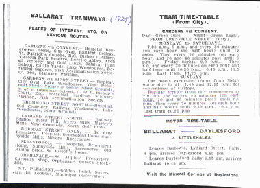
Eleven sheets - photocopy and covering letter - from a 1929 Guide to Ballarat, detailing timetable for trams and buses on various routes. Tram timetables - gives Gardens via Convent, Gardens via Ripon, Drummond St North, Lydiard St North, Rubicon St, Sebastopol, Orphanage, Mount Pleasant and associated return timetables. Gives details of first cars, frequency and times past each hour basis and changes in service frequency. Details colours of the discs that the trams carry to identify them to passengers, day and night. Gives Bus timetables and operator names for: Daylesford (J. Littlehales), Monastery Bus Service (W. Wilson), Ballarat Nth and New Cemetery via Doveton St (H. W. Smith), Victoria Park via Doveton and Eyre St (Robinson), South St bus service to Western oval and racecourse (A. Sproule) and Ballarat to Elmhurst (Sandlants).trams, tramways, timetables, buses, ballarat, esco -
 Ballarat Tramway Museum
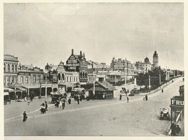
Photograph - Black & White Photograph/s, c1912
Yields information about the lower end of Sturt St, the tram terminal, the waiting shelter, the streetscape and how the street was used at the time.Black and white photograph of Sturt St. looking west from Grenville St, post 1912? Shows two ESCo trams, with driver's windows, advertising boards and trams converted for one man operation adjacent to the Grenville St. shelter. A motorcar is parked on the north side of Sturt St (right hand side of photo). On the bottom of the item is the words "Two Views of Sturt St." Buildings of the west side of Sturt St - W. Owen Sports Depot, Suttons Pianos, Organs and Music and the Mechanic's Institute. See Further information for Alan Bradley's notes on the shelter - ex an email dated 30/7/2004, following an enquiry from Max Harris. See Reg Item No. 1671 for the other "Two Views of Sturt St." image. Copy 2 - added 29/7/2007 from Alan Bradley collection of photographs, to the depot 5/2007. On rear of copy 2 in pencil "Alan Bradley"tramways, trams, esco, sturt st., ballarat, grenville st -
 Ballarat Tramway Museum
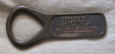
Functional Object - Section Staff, Electric Supply Co. of Vic (ESCo), "Victoria Park Loop / Carlton St Loop"
Demonstrates aspects of Safeworking on the Ballarat Tramway system from 1960 to c1936 when replaced by electric signs. Yields Information about the operation of Ballarat's trams and safeworking procedures.Cast brass item with a flat part recessed section with the words "BALLARAT TRAMWAYS SECTION STAFF" cast into the surface and a flat section underneath, flush with the outside edges in which the words "VICTORIA PARK LOOP / CARLTON ST LOOP" stamped in. Has an open rounded end which forms a handle or a point where it could be hung on a peg. The top line of words has a reddish paint inlay. Used as a means of authorising a tramcar to have sole use of the track between the named points to avoid head on collisions. Safeworking object - known as a section staff. Not known when made, but in use until the introduction of the electric signalling in the mid 1930's by the SEC. See also Reg Items 934 and 988 for details of use and other examples are at 1851, to 53, 2473 and 4444 to 4448 and Reg item 934 and 988 for articles on the safeworking systems.trams, tramways, staff, safeworking, tramway staffs, sec, signals -
 Ballarat Tramway Museum
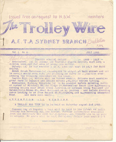
Magazine, Australian Electric Traction Association (AETA), "The Trolley Wire", Vol 1, No. 6, "The Trolley Wire", Vol 3, No. 5, Jul. 1952
Yields information about Sydney trams in the early 1950s and demonstrates means of publishing information of the era.105.1 - Spirit duplicated magazine, 8 quarto pages, single sided - " The Trolley Wire", Vol 1, No. 6, July 1952, stapled down along the left hand side. Has items on Brisbane, with map, Brisbane news, Sydney news, Gladesville to Lane Cove proposed tramway and Western Suburbs Destination Roll, 1947 - 1950. 105.2 - Spirit duplicated magazine, 9 quarto pages, single sided - " The Trolley Wire", Vol 3, No. 5, 20th May 1954, stapled down along the left hand side. Has notes on association matters, map of tramways in the Moore Park area, Drummoyne Bridge and Iron Cove tram lines, Easter workings, Sydney news. See Reg Item 5685 for other Vol 1 issues and Reg Item 5686 for Vol. 2 issues. Scan with care.Vol 3, No. 5 has pencil inscription of "H.Matthews"trams, tramways, tramway news, history, sydney, brisbane -
 Kew Historical Society Inc
Archive (Sub-series) - Subject File, Fernhurst (Kew), 1973
Various partiesReference, Research, InformationSecondary Values (KHS Imposed Order)Subject file containing research related to George Wharton and his house Fernhurst, originally situated on the corner of Princess Street and Studley Park Road, but later subdivided. The house was in the 20th century converted into flats and later bought by the Catholic Church, who established St Paul’s School for the Blind on the site. The situation was complicated as the Church also bought the neighbouring Neama and Mandalay. Villa Maria and St Paul’s School currently occupy the site. Part of the site was later subdivided to create Elphinstone Court. The file contains photocopied extracts from histories and detailed research and correspondence between the School, the Kew Historical Society, the National Trust of Victoria, and the Historic Buildings Preservation Council relating to both Neama and Fernhurst. There is a reference in a letter from St Paul’s inviting the Society to collect artefacts from the site. There are no known current items in the collection relating to the collection of these. kew (vic) - history, victorian architects - george wharton, fernhurst (kew), st paul’s school for the blindkew (vic) - history, victorian architects - george wharton, fernhurst (kew), st paul’s school for the blind -
 Kew Historical Society Inc
Photograph, J F C Farquhar, Dight's Falls, 1891
At the beginning of the 1890s, the Kew businessman and Town Councillor, Henry Kellett, commissioned J.F.C. Farquhar to photograph scenes of Kew. These scenes included panoramas as well as pastoral scenes. The resulting set of twelve photographs was assembled in an album, Kew Where We Live, from which customers could select images for purchase.The preamble to the album describes that the photographs used the ‘argentic bromide’ process, now more commonly known as the gelatine silver process. This form of dry plate photography allowed for the negatives to be kept for weeks before processing, hence its value in landscape photography. The resulting images were considered to be finely grained and everlasting. Evidence of the success of Henry Kellett’s venture can be seen today, in that some of the photographs are held in national collections.It is believed that the Kew Historical Society’s copy of the Kellett album is unique and that the photographs in the book were the first copies taken from the original plates. It is the first and most important series of images produced about Kew. The individual images have proved essential in identifying buildings and places of heritage value in the district.Dight’s Falls in Studley Park is an artificial weir built on a natural rock bar across the Yarra. The weir was built in the 1840s to provide water to the ‘Ceres’ flour mill, one of the earliest industrial sites in Melbourne. The falls were later to be named after the owner of this mill. In 1888, William Guilfoyle, Director of the Melbourne Botanical Gardens had called for fresh water to be piped from above the weir to the Botanical Gardens, using a pumping station on the Kew side of the Falls, a holding reservoir in Walmer Street and a series of pipes from there to the Gardens. This system was opened in May 1891. Farquhar’s photograph of the man-made weir obscures the industrial activity on both sides of the Falls and focusses solely on the river and the surrounding natural vegetation. The photograph probably predates the disastrous flooding of the Yarra River in July 1891, the greatest to have occurred in the Colony since the foundation of Melbourne.Dight's Fallskew illustrated, kew where we live, photographic books, henry kellett, yarra river -
 Kew Historical Society Inc
Photograph - Zig-Zag Bridge, 1924
Henry Beater Christian (1886-1962) , was a descendant of one of the earliest settler families in Kew. Employed at the Kew Asylum as a 'public servant', he was a skilled amateur photographer, photographing numerous scenes in Kew and on his travels around Victoria. The majority of his photographs date from 1916 to 1929. His finest photographs are housed in two photograph albums. Digital copy of a photograph from page 8 of the 47-page photograph album containing 261 gelatinous silver images, loaned by Diane Washfold with permission given to digitise and hold a copy in our collection. This photograph reveals how the photographer, Henry Christian, positioned himself to take the photograph from the angle in which he was interested. A skilled canoeist, an empty canoe is on the left of the photo that he apparently he used to access his vantage point. His subject, the Zig-Zag Bridge linked the grounds of the Yarra Bend and Kew Asylums. The wooden bridge was constructed in the 1870s and lasted through numerous floods until its destruction in 1929. A horizontal structure, one climbed steps to reach the higher Yarra Bend bank. At the Studley Park end, the bridge descended via a staircase to reach the much lower bank. "Zig-Zag Bridge"henry beater christian (1886-1962), landscape photography, kew (vic.) — yarra river, christian-washfold collection, photograph albums, zig-zag bridge -
 Kew Historical Society Inc
Photograph - Zig-Zag Bridge, 1924
Henry Beater Christian (1886-1962) , was a descendant of one of the earliest settler families in Kew. Employed at the Kew Asylum as a 'public servant', he was a skilled amateur photographer, photographing numerous scenes in Kew and on his travels around Victoria. The majority of his photographs date from 1916 to 1929. His finest photographs are housed in two photograph albums. Digital copy of a photograph from page 8 of the 47-page photograph album containing 261 gelatinous silver images, loaned by Diane Washfold with permission given to digitise and hold a copy in our collection. This photograph reveals how the photographer, Henry Christian, positioned himself to take the photograph from the angle in which he was interested. A skilled canoeist, an empty canoe is on the left bank that he apparently he used to access his vantage point. His subject, the Zig-Zag Bridge linked the grounds of the Yarra Bend and Kew Asylums. The wooden bridge was constructed in the 1870s and lasted through numerous floods until its destruction in 1929. A horizontal structure, the walkway was reached via a wooden staircase on the Studley Park end. The steps were requires due to the different levels of the banks on this stretch of the river. "Zig-Zag Bridge"henry beater christian (1886-1962), landscape photography, kew (vic.) — yarra river, christian-washfold collection, photograph albums, zig-zag bridge -
 Kew Historical Society Inc
Photograph - Zig-Zag Bridge, 1924
Henry Beater Christian (1886-1962) , was a descendant of one of the earliest settler families in Kew. Employed at the Kew Asylum as a 'public servant', he was a skilled amateur photographer, photographing numerous scenes in Kew and on his travels around Victoria. The majority of his photographs date from 1916 to 1929. His finest photographs are housed in two photograph albums. Digital copy of a photograph from page 8 of the 47-page photograph album containing 261 gelatinous silver images, loaned by Diane Washfold with permission given to digitise and hold a copy in our collection. This photograph reveals how the photographer, Henry Christian, positioned himself to take the photograph from the angle in which he was interested. A skilled canoeist, an empty canoe is on the left bank that he apparently he used to access his vantage point. His subject, the Zig-Zag Bridge linked the grounds of the Yarra Bend and Kew Asylums. The wooden bridge was constructed in the 1870s and lasted through numerous floods until its destruction in 1929. A horizontal structure, the walkway was reached via a wooden staircase on the Studley Park side. The steps were requires due to the different levels of the banks on this stretch of the river. "Zig-Zag Bridge"henry beater christian (1886-1962), landscape photography, kew (vic.) — yarra river, christian-washfold collection, photograph albums, zig-zag bridge -
 Kew Historical Society Inc
Photograph - Grampians, 1924
Henry Beater Christian (1886-1962) , was a descendant of one of the earliest settler families in Kew. Employed at the Kew Asylum as a 'public servant', he was a skilled amateur photographer, photographing numerous scenes in Kew and on his travels around Victoria. The majority of his photographs date from 1916 to 1929. His finest photographs are housed in two photograph albums. Digital copy of a photograph from page 12 of the 47-page photograph album containing 261 gelatinous silver images, loaned by Diane Washfold with permission given to digitise and hold a copy in our collection. The first and last pages in the album document the Yarra River at Studley Park and at Kew. The remainder of the album includes photographs of walking and car tours in rural Victoria including 'wilderness' areas in the Grampians, Gippsland and the High Country. Six album pages document a camping trip by Henry Christian to the Grampians in September 1924. The photos include pictures of lookouts, and natural features including rock faces and waterfalls, as well as his camp site. This photo is of a man, perhaps Henry Christian, holding his camera while standing on one of the lookouts on what is probably the Mt Victory trail. The photo was framed in a circle during the development process. "Mt Victory / Grampians / 9.24"henry beater christian (1886-1962), landscape photography, christian-washfold collection, photograph albums, grampians, mt victory, gariwerd -
 Kew Historical Society Inc
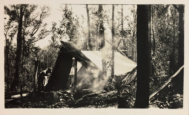
Photograph - Campsite in the Grampians, 1924
Henry Beater Christian (1886-1962) , was a descendant of one of the earliest settler families in Kew. Employed at the Kew Asylum as a 'public servant', he was a skilled amateur photographer, photographing numerous scenes in Kew and on his travels around Victoria. The majority of his photographs date from 1916 to 1929. His finest photographs are housed in two photograph albums. Digital copy of a photograph from page 12 of the 47-page photograph album containing 261 gelatinous silver images, loaned by Diane Washfold with permission given to digitise and hold a copy in our collection. The first and last pages in the album document the Yarra River at Studley Park and at Kew. The remainder of the album includes photographs of walking and car tours in rural Victoria including 'wilderness' areas in the Grampians, Gippsland and the High Country. Six album pages document a camping trip by Henry Christian to the Grampians in September 1924. The photos include pictures of lookouts, and natural features including rock faces and waterfalls, as well as his camp site. This photo is of one of his campsites. The tent, beside which a man is standing, is a simple canvas sheet held up by ropes and supported at one end by large slabs of bark. "Mt Victory / Grampians / 9.24"henry beater christian (1886-1962), landscape photography, christian-washfold collection, photograph albums, grampians, mt victory, gariwerd -
 Kew Historical Society Inc
Photograph - Grampians, 1924
Henry Beater Christian (1886-1962) , was a descendant of one of the earliest settler families in Kew. Employed at the Kew Asylum as a 'public servant', he was a skilled amateur photographer, photographing numerous scenes in Kew and on his travels around Victoria. The majority of his photographs date from 1916 to 1929. His finest photographs are housed in two photograph albums. Digital copy of a photograph from page 15 of the 47-page photograph album containing 261 gelatinous silver images, loaned by Diane Washfold with permission given to digitise and hold a copy in our collection. The first and last pages in the album document the Yarra River at Studley Park and at Kew. The remainder of the album includes photographs of walking and car tours in rural Victoria including 'wilderness' areas in the Grampians, Gippsland and the High Country. Six album pages document a camping trip by Henry Christian to the Grampians in September 1924. The photos include pictures of lookouts, and natural features including rock faces and waterfalls, as well as his camp site. This is a photo of a man in the distance on a bush track who is looking over his shoulder at the camera. He carries a sack and has a swag on his back. This may be Henry Christian or a companion."Grampians"henry beater christian (1886-1962), landscape photography, christian-washfold collection, photograph albums, grampians, gariwerd -
 Kew Historical Society Inc
Plan - Subdivision Plan, Wimba Estate, Kew, c.1925-c.1929, ca. 1925-ca. 1929
Pru Sanderson, in her groundbreaking ‘City of Kew Urban Conservation Study : Volume 2 - Development History’ (1988), summarised the periods of urban development and subdivisions of land in Kew. The periods that she identified included 1845-1880, 1880-1893, 1893-1921, 1921-1933, 1933-1943, and Post-War Development. These periods were selected as they represented periods of rapid growth or decline in urban development. An obvious starting point for Sanderson’s groupings involved population growth and the associated economic cycles. These cycles also highlighted urban expansion onto land that was predominantly rural, although in other cases it represented the decline and breakup of large estates. A number of the plans in the Kew Historical Society’s collection can also be found in other collections, such as those of the State Library of Victoria and the Boroondara Library Service. A number are however unique to the collection.Subdivision plans are historically important documents used as evidence of the growth of suburbs in Australia. They frequently provide information about when the land was sold on which a built structure was subsequently constructed as well as evidence relating to surveyors and real estate and financial agents. The numerous subdivision plans in the Kew Historical Society's collection represent working documents, ranging from the initial sketches made in planning a subdivision to printed plans on which auctioneers or agents listed the prices for which individual lots were sold. In a number of cases, the reverse of a subdivision plan in the collection includes a photograph of a house that was also for sale by the agent. These photographs provide significant heritage information relating house design and decoration, fencing and household gardens.In 1925, the City of Kew called for tenders for the construction of Wimba Avenue, Cadow Street and Lalla Street. Subsequent advertisements for the sale of land in Wimba Avenue continued from 1926 to 1929. The 18 lots (and a further five allotments on the eastern side of the street) offered for sale were unofficially described in the subdivision plan as the ‘Wimba Estate’. These lots began in Park Hill Road and extended almost to Cotham Road. The subdivision took its name from the house ‘Wimba’ in Cotham Road, which may have formed the southern boundary of the subdivision. (Wimba, at 235 Cotham Road was constructed between 1862-70). The Plan highlights the proximity and advantage of ‘electric’ trams in Cotham and Glenferrie Roads, and the Kew and Glenferrie Railway Stations. An oddity in the Plan is the reference to the electric tram terminus at Burke Road, given that the tramline had already been extended to Mont Albert in 1916.wimba estate, subdivision plans - kew, parkhill road – kew (vic.), normanby road – kew (vic.), wimba avenue – kew (vic.) -
 Kew Historical Society Inc
Uniform - Girl Guide Uniform, 6th Kew, Scout Association of Victoria, c.1987
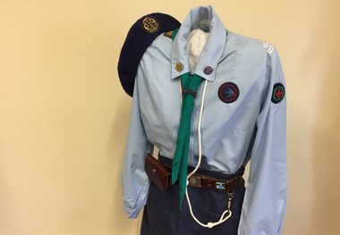
This Guide uniform was worn by Jane Reid when she was a Guide at 6th St Hilary's between 1987 and 1989. The uniform consists of a pale blue blouse, junior navy A-line skirt and navy wool beret with the World Guide badge embroidered on it. The scarf with the Victorian State Badge at the back is a triangle and can be used as a sling or bandage in an emergency. Jane's woggle (a band holding the tie) was made by hand. Some girls made woggles from leather, cord or items from nature such as gumnuts. The leather belt with the Girl Guide buckle bears a metal badge obtained at Britannia Park, the Victorian Guide camping ground at Yarra Junction. Her white lanyard (indicating she was a Patrol Leader) and brown leather pouch are attached to the belt. Metal badges pinned to the collar of the blouse are the World Guide badge on the right and the Guide Trefoil or Promise badge on the left. The tapes on the left sleeve identify the Guide Company, District and Region. Badges on the right sleeve are interest and achievement badges.jane reid, costumes, uniforms, girl guides 6th kew -
City of Kingston
Photograph - Colour, 6 March 1993
Edithvale is a suburb in the City of Kingston. It is located between Aspendale and Chelsea on the Port Phillip Bay and built within remnant areas of the Carrum Carrum swamp. The foreshore precinct comprises a wide sandy beach, with low sand dunes and numerous historic boat sheds. The suburb consists of older style dwellings and former holiday houses, combined with mid-century housing and newer homes. The large blocks are increasingly subdivided and the existing dwellings demolished to accommodate units and townhouses, thus changing the landscape of the area and reducing the tree canopy.The beachside suburb of Edithvale was previously part of the extensive Carrum Carrum Swamp. The area was once a source of fish and eels for the Mayone-Bulluk clan of the Bunurong people. Over time the area was drained and predominantly devoted to dairy farming and holiday houses. The farms were gradually sold and subdivided with a large number of homes built after World War II and in the 1960s. Edithvale is mainly residential with a shopping strip along Nepean Highway but little significant industry was ever established in the area apart from a plaster works and confectionary factory, both now closed.Laminated aerial colour photograph of Edithvale as viewed from Alexandra Avenue in the north to Ella Grove Chelsea/Edithvale in the south. regents Park Aspendale can be seen in the top left. The area is built-up with residential housing and facilities including Edithvale Primary School, numerous churches and the Edithvale Railway station. Large sections depict the remnant Carrum Carrum swamp. Edithvale Common and the former "Duck Inn" (Melbourne Water/Friends of Edithvale Seaford Wetlands) can be seen. Edithvale Recreational reserve, the valodrome and Edithvale Public Golf Course are prominent. The image shows vacant land in the area now known as Aspendale Gardens and the newer residential section of Chelsea Heights is not developed. A bike path has been established to cover the secondary drain. The Golf Links Court residential development located off Hughes Avenue is a large vacant block.Black type on white adhesive label: 6-3-93 Black type on white adhesive label: 25/9211, 6/3/93, 11.20 am Black type on white adhesive label: 9211 Yellow circular adhesive sticker Black pencil: 9211 6-3-93 arrow pointing Nedthvale, carrum carrum swamp, aspendale, chelsea -
 Bendigo Historical Society Inc.
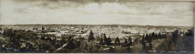
Photograph - BENDIGO FROM CAMP HILL FIRE TOWER, c.1905
BHS CollectionBlack and white/sepia? Photograph mounted on green board. Narrow panoramic view of 'Bendigo from Camp Hill Fire Tower'. Rosalind Park in foreground., School of Mines, Town Hall, Bendigo Arcade, Banks, The Beehive, City Family Hotel, Law Courts and Post Office in foreground. Shamrock Hotel to left. Poppet legs of Royal Hustler's Mine Pall Mall. Inscriptions: 'Copyright Melb. P Scott', 'Bendigo from Camp Hill Fire Tower'. Royal Historical society of Victoria, Bendigo Branch, Circular blue stamp on back. 'MP270' TR corner. Portion of oval stamp on bottom right. Hand printed across bottom in ballpoint pen 'property of HJG Biggs, Town Hall Eaglehawk'. Portion of oval rubber stamp, purple, 'T. CA.., FOO.. Mark.. Be..' History: Previous Acc. No. MP 270.P Scottplace, landscape view, bendigo, bendigo, rosalind park, school of mines, bendigo town hall, camp hill, landscape, post office, bendigo post office, shamrock hotel, pall mall, fire tower -
 Melbourne Tram Museum
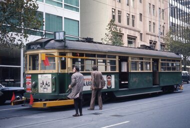
Slide - Set of 5, Ron Scholten, May. 1973
Set of five colour slides, white/red cardboard, Duplicates by Pacific Film Laboratories of tram 912 in the City area testing clearances around safety zones, as part of the development of the Z class tram. Done on a Sunday morning. .1 - Bourke St showing the various equipment or protrusions attached to the tram in order to test clearances to safety zones at crossings. .2 - about to travel through a crossover. .3 - using the Queen or William St crossover. Tram has adverts for Tolleys Brandy and PGF Golf clubs. .4 - ditto - with tram 1021 running a route 97 to North Fitzroy Park St. .5 - ditto- with adverts for Williamson Real Estate and All Saints winery. See also Reg Item 3795 for Black and White and Reg Item 4611 for photos of the event and the use of car 1018.All have a running number "1204" to "1208" and "912" written on the slide.trams, tramways, sw6 class, testing, safety zone, bourke st, safety, z class, north fitzroy, route 97, tram 912 -
 Bendigo Historical Society Inc.
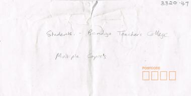
Photograph - LA TROBE UNIVERSITY BENDIGO COLLECTION: BENDIGO TEACHERS' COLLEGE STUDENTS
BHS CollectionAn envelope which contained multiple copies of photos of students at Bendigo Teachers' College in 1947, the 1950's and the 1960's. on rear of photo is stamped: Geoff & Pam Pryor, "Langley" 50 Miller Street Bendigo 3550, Tel: (054) 424471. One black and white photograph of Bendigo Teachers' College students in 1947 taken at the base of the Lookout Tower in Rosalind Park Bendigo. One black and white photo of Bendigo Teachers' College students in the 1950's. Man in second row extreme right named as George Vincent. One black and white photograph of Bendigo Teachers' College students in the 1960's. 15 copies of a black and white photo of Bendigo Teachers' College students in the 1960's. Two black and white photos of Bendigo Teachers' College students in the 1960's. 2 copies.bendigo, education, bendigo teachers' college students, la trobe university bendigo collection, collection, photography, photo, photographs, photograph, bendigo teachers' college, male, female, students, education, envelope, bendigo teachers' college students, bendigo, teacher training, tertiary education, history, bendigo teaches' college history -
 Melbourne Tram Museum
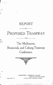
Document - Photocopy, Valentine J. Crowley Consulting Engineer, "Report on Proposed Tramway for The Melbourne, Brunswick and Coburg Tramway Conference", Original 1915
Photocopy - Report - 12 pages - titled "Report on Proposed Tramway for The Melbourne, Brunswick and Coburg Tramway Conference", prepared by Valentine J. Crowley Consulting Engineer Oct. 25, 1915. Looks at the construction of a tramway Flinders St along Queen St, to Royal Park, to Sussex St and Gaffney Road, West Coburg for the Melbourne Brunswick and Coburg Tramways Trust. Looks at the route and length of track in detail, route, administration, population, construction, permanent way, overhead lines, feeders, rolling stock, timetable, capital cost, alterations to services, expenditure for year and conclusion. Has a map of the proposed route. Included with the document is a plan of the MBCTT lines, overwritten in ball point pen with street names dated Dec. 1919. Photocopy made from original documents - has been stapled along the side in three places.trams, tramways, mbctt, maps, new tramway, west coburg, queen st, royal park -
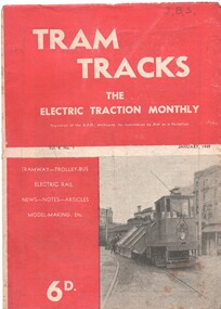 Melbourne Tram Museum
Magazine, Jack Richardson, "Tram Tracks - The Electric Traction Monthly", Jan. 1949
Vol. 4 No. 1, January 1949 of "Tram Tracks - The Electric Traction Monthly" of the Australian Electric Traction Association. Magazine consists of 20 printed pages, with a single staple on the saddle. Contains a photo of the construction of the Victoria Parade tram line, article "Trams and the Motorist", items on Melbourne (Bourke St, "Higher costs with Buses - Melbourne Experience", Brisbane, Newcastle, Sydney, Monorails, railway map of Australia track gauges, (centre page), Brisbane Tramways, Melbourne and Sydney electric trains, and letter to the Editor from John Buckland - not supportive of Bourke or Latrobe St tramways. Issue has advertisements for the Model Dockyard, ARLHS, The Hobby Shop, Barnes Tennis Centre, Fleet, Christie Model Railway Equipment of Sydney, Meadmore Model Engineering, Austral Bronze, Wattle Park, Traction Publications and Robilt "O" gauge locomotives, Parker & Gray, The Model Dockyard,Has initials "JBS" in top right hand corner in pencil.trams, tramways, electric traction, aeta, australian tramways, mmtb, pcc, sydney, newcastle, brisbane, bourke st -
 Melbourne Tram Museum
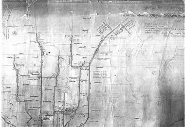
Drawing, Melbourne & Metropolitan Tramways Board (MMTB), "Plan of Tramway System - showing route mileage of electric tramways", Late 1960's
Set of 9 A3 photocopy of a drawing - of a dyeline print that had been mounted onto a cloth backing and had been kept up to date with regard to extensions and closures or opening and closing - titled - "Plan of Tramway System - showing route mileage of electric tramways" - Principal Junctions and intersections shown diagrammatically. Map of system shown at 40 chains to the inch. Copy of Drawing No. P6050. Shows crossovers, signal cabins, automatic points, closed cable tram lines in the city area, Port Melbourne, roads, railways and stations. Has extensions to Mill Park up to April 1987. Shows the Port Melbourne, North Melbourne (Spencer and Abbotsford Sts) and Collingwood cable lines, the Footscray system lines and the Point Ormond lines. See also Reg Item 1561 for a late 1960's print and 3642 for a 1941 version.trams, tramways, mmtb, trackwork, tramways, junction, map -
 Melbourne Tram Museum
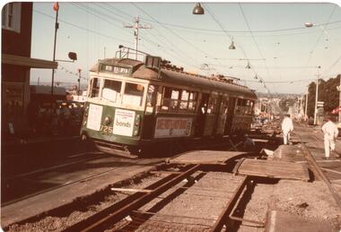
Photograph - Black and White photograph, mid to late 1970's
Set of five colour prints of tram W5 725 derailed in High St Kew during track reconstruction work at the corner of Derby St Kew. Tram was bound for North Balwyn when it derailed on a section of track that had been dismantled, possibly when it hit or dislodged a track crossover. Tram has advertisements for Bonds, Tollana Wines, Park Drive cigarettes, .1 - tram derailed at the top of the hill down to Kew Cemetery. .2 - with workmen setting up the tram and place on the temporary transport wheels. The second axle box towards the drop centre is on an angle compared to the nearest axle box. .3 - close up view of the damaged truck. .4 - General view of the scene looking back towards Kew Junction. .5 - view of the damaged crossover section. Date: during the 1970's.trams, tramways, accidents, derailments, kew, high st, north balwyn, route 48, temporary track, tram 725 -
 Melbourne Tram Museum
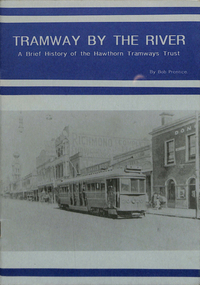
Book, Bob Prentice, Peter Bardho, "Tramway by the River - a brief history of the Hawthorn Tramways Trust", 1993
Book - 16 pages printed on off white paper plus light card cover printed on grey paper, titled "Tramway by the River - a brief history of the Hawthorn Tramways Trust". Originally written by Bob Prentice in a TMSV Running Journal of 1966 (Vol. 2 No. 4), then to a booklet by Peter Bardho of Tramway Publications in 1993. Covers the history of the trust, those involved, horse tram, operations, Riversdale Road extension, mileage, track layout with plans, overhead, rollingstock, the Burwood accident of Jan. 1917, depot, substation, Wattle Park, employees strike, fares and sections, annual balance sheets, timetables, rolling stock data, disposal and an epilogue following the establishment of the MMTB. Has numerous photos. 2nd Edition, published by Tramway Publications 2016, Edited by Dean Filgate - digital image added 7/8/2020 as htd1117i2.pdf.trams, tramways, htt, burwood, accidents, depot, hawthorn, tramcars, tmsv, wattle park, employees -
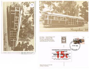 Melbourne Tram Museum
Postcard, Australia Post, "Stampshow '89", Oct. 1989
Set of seven postcards associated with "Stampshow '89", collected by Robert Green at the time of the event. Postcards - Melbourne trams printed in Sepia colours with details of the trams on the rear, photo source, Stampshow '89 with its tramcar logo and location for a stamp. .1 - W431 .2 - W431 with a 41c stamp on rear, and the MMTB Prepaid "fare" or newspaper stamp affixed. Has been postmarked "Stampshow TPO 21 October 1989 Melbourne" .3 - W431 in plastic envelope with a $1 price label. .4 - Decorated cable car set - 1919 - wrapped with price label. .5 - W6 982 with Luna Park in background - wrapped with price label. .6 - Hawthorn Horse tram car with crews around it - wrapped with price label. .7 - B2 2005 on St Kilda Esplanade - wrapped with price label. 2nd copy of each added 22/7/2020trams, tramways, postcards, mmtb, horse trams, cable trams, stamps, post office, tram 431, tram 982, tram 2005 -
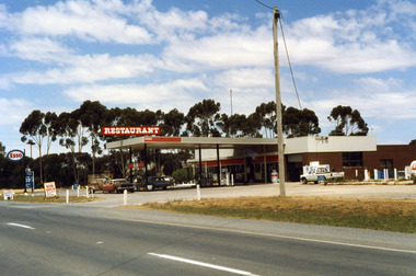 Charlton Golden Grains Museum Inc
Photograph, Charlton Shire, Charlton Roadhouse c. 1987, c.1987
The Charlton Roadhouse was established in the 1960s (TBC)Colour photograph of the Charlton Roadhouse taken from the other side of the highway looking south east. The highway is visible in the lower part of the photo. The roadhouse is a single storey building with large windows at the front. There is a large roof extending over the petrol pumps. There is a large sign on the roof which reads RESTAURANT. A brown coloured car with a white roof, dark bonnet and towing a trailer is facing toward the photographer. A man is getting the driver's side. A lighter coloured car is facing away from the photographer and a man is beside this car. There is a white Toyota utility parked on the right hand side of the roadhouse in front of the ice storage. There is a small sign for ESSO on the roof edge and a freestanding sign for ESSO close to the entrance to the roadhouse. There is a sign on wheels near the road reading NOW OPEN and another that reads L.P. GAS AUTO GAScharlton roadhouse, business, industry, charlton -
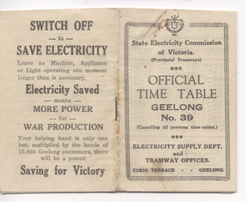 Ballarat Tramway Museum
Ephemera - Timetable, "Official Timetable Geelong No. 39", 1943
Printed, single stapled 8 sheets folded and titled SECV "Official Timetable Geelong No. 45", 16 image files - 32 pages, giving details of the fares, transfers, luggage or parcels, lost property, times of each tram on the Newtown, West Geelong, East Geelong, Chilwell, Eastern Park, Belmont,, North, . Gives details of fares, luggage, lost property. On rear has an SECV Advert to "Switch Off to Save Electricity - Saving for Victory" Timetable undated, probably c1943 - see Reg Item 5633 for date forwarded to Wal Jack from Geelong SECV office - was the then current timetable. See also Reg Item 5357 for Timetable No. 45, c1949 and 8552 for a photocopy of No. 47, March 1953 and 9821 for a photocopy of No. 46 Contained originally within Reg Item 5623 at the front of this note book. For items see btm5623 loose items list.pdfgeelong, timetables -
 City of Moorabbin Historical Society (Operating the Box Cottage Museum)
Newsletter - City of Moorabbin Historical Society Oct 2012, October 2012
The City of Moorabbin Historical Society was formed c 1960 by a group of Moorabbin area residents who were concerned that the history of the area should be preserved. A good response to a call for items related to the historical area of Moorabbin Shire brought donations of a wide variety of artefacts that are now preserved by the current members of CMHS at Box Cottage Museum. Helen Stanley, Secretary of CMHS, began producing a Newsletter for members in April 2007 to provide current information and well researched items of historical interestHelen Stanley has produced a bi-monthly Newsletter, 2007 - 2013, for the members of the City of Moorabbin Historical Society that contains well researched interesting historical items, notification of upcoming events, current advice from Royal Australian Historical Society , Museums Australia Victoria and activities of Local Historical Societies. The Newsletter is an important record of the activities of the CMHS.4 x A4 paper printed on 1 side Issue 29 of the bi-monthly, City of Moorabbin Historical Society Newsletter produced by Society member and Secretary, Mrs Helen Stanley in October 2012. Notice of AGM October 28th , and Box Cottage Museum will be Open on 27th and 28th for History Week. Jessica Bennett, Reporter for The Leader Newspaper, has been asked to promote the History Week Open Days, volunteers have distributed fliers, and Glen Eira CC Parks and Gardens officers have removed the dead tree. Volunteer photographers from Caulfield Photography Group have helped our members to catalogue the Museum artefacts and we are progressing well.. An unfortunate electricity account was referred to GECC for advice. Helen has given an essay, of 3x A4 pages, about The Lees Family pioneer market gardeners as researched by Jan Rigby, a descendant. CITY of MOORABBIN HISTORICAL SOCIETY / OCTOBER 2012 NEWSLETTERcity of moorabbin historical society, stanley helen, melbourne, moorabbin, brighton, cheltenham, ormond, bentleigh, market gardeners, pioneers, early settlers, the moorabbin roads board 1862, city of glen eira, city of kingston, moorabbin shire, parish of moorabbin, brighton east, south brighton, bent tommy, mair william, jessse morleys hotel, lees james, lees william, convicts, jamison john, bent james, lees james henry, lees joseph, lees jack allen,