Showing 23235 items matching "smythes-creek"
-
 Greensborough Historical Society
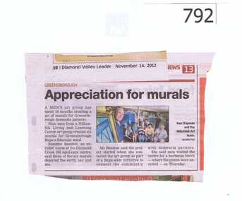
Newspaper clipping, Diamond Valley Leader, Appreciation for murals, 14/11/2012
An article about a men's art group which won an award for creating murals.The group is from Nillumbik Living and Learning Centre and the murals were created for dementia patients at the Diamond Creek Rd Aged Care centre.A small article featuring a colour photograph.Nilnillumbik living and learning centre, diamond creek road aged care centre, mens art groups, murals, dementia -
 Greensborough Historical Society
Newspaper Clipping, Diamond Valley Leader, Cronin killer guilty, 13/09/2017
A coward punch killer has pleaded guilty to manslaughter over the death of teen footballer Patrick CroninNews article 1 page, black text.patrick cronin, footballer, coward punch, diamond creek, lower plenty football club, cronin family -
 Greensborough Historical Society
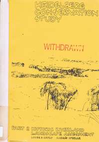
Book, Heidelberg Conservation Study: Part 2: Historic Riverland Landscape Assessment. Revised 1987, 1987_
Report prepared by Loder and Bayly and Marilyn McBriar on behalf of City of Heidelberg and Heidelberg Heritage Advisory Committee. Area covered is from Darebin Parklands in the south to Plenty River at Yallambie in the north. Revised 1987.This study identifies neighbourhood character, documents past development and the capacity of the environment for future development with particular emphasis on the river precincts - Plenty River, Yarra River and Darebin Creek.Part three of set of three books. Paperback, 333 pages, Illus., maps. 2 copies.Stamps: Yarra Plenty Regional Library Service, and, Withdrawnheidelberg, macleod, heidelberg heritage advisory committee, marilyn mcbriar, plenty river, yarra river, darebin creek -
 Halls Gap & Grampians Historical Society
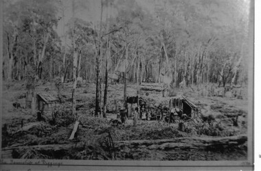
Photograph - B/W, C 1887
Photo depicts dwellings with people standing in front. A man is holding a horse loaded with bags. Huts in forground and background.the township at Diggings marked on frontmining, stoney creek -
 Bairnsdale RSL Sub-Branch Inc.
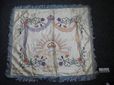
memento embroidered, 1940
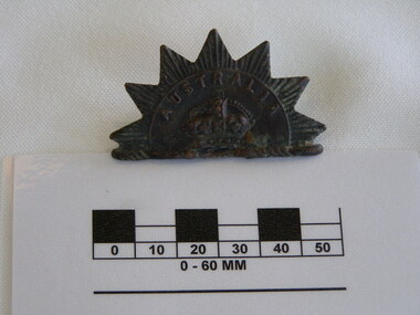
Hand embroaded on silk memento by Bill Handcock to his mother from Pelestine 1940. Main feature is the Rising Sun Bagde.silk hand embroaded memento Mrs P G Handcock from Bill Palistine 1941 Australian Commonwealth Military Forces Rising Sun Badge in centre Crown is centered on top of Garlands with flowers embossed in corners Blue fringed on all edges"Palestine" Lower L/H Side, "1940" Lower R/H side, "Mrs P G Handcock /From Bill" centre bottom, "Australian Commonwealth /Military Forces, on Rising-Sun-Badge centre world war two, embroidery, memento, rising sun badge, palestine, 1940, handcock -
 Bairnsdale RSL Sub-Branch Inc.
Rising Sun hat badge, Australia, late 19th century
The first Rising Sun badge design is by no means a mirror image of the Trophy of Arms on which it is thought to be designed. But it comes close to being a mirror image of part of the badge worn by the Victorian Cadet Forces circa1890. (WWW.diggerhistory)SignificantRising Sun Badge Seven star with crown surmounted by the word "Australia". First Pattern Hat BadgeSeven Sun Star raidiating lines Australia inscribed over crownaustralia -
 Bairnsdale RSL Sub-Branch Inc.
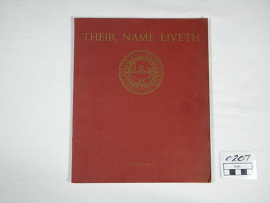
Commonwealth War Graves Commission, Her Majestry,s Stationary Office by the Campfield Press, Their Name Liveth Vol VI Part II, 1968
Some Pictures of War Cemeteries of South -East Asia,The Pacific Islands and Japan 1914-1918 and 1939-1945Red covered book Their name Liveth on top of cover Seal of Commonwealth War Graves Commission under TitleTheir Name Liveth Commonwealth War Graves Commissionjapan, war, east, port, islands, new, guinea, south, cemeteries, asia, pacific, fiji, caledonia, adelaide, rabaul, lea, morsby, labuan, yokohama, kranji, singaporechangi, kanchanaburi, thailand, thanbyuzayat, burma -
 Bairnsdale RSL Sub-Branch Inc.
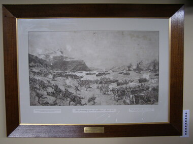
Print Anzacs Landing at Gallipoli, Landing of the Anzacs 25 April 1915
Displayed in the Bruthen Shire office untill shire ammalgamation Localy historicaly significantPrint framed under glassPresented to the Shire of Tambo from the Bruthen Sub-Branch R.S.L.I.L.A. June 9th 1925 (RHS) Presented to the Australian Commonwealth Governement by Austin Taylor esq London (LHS) From the original picture by Charles Dixon now in the National Art Gallery Sydneyanzac, landing at anzac cove, 25th april 1915, shire of tambo, austin taylor esq london, charles dixon, national art gallery sydney -
 Eltham District Historical Society Inc
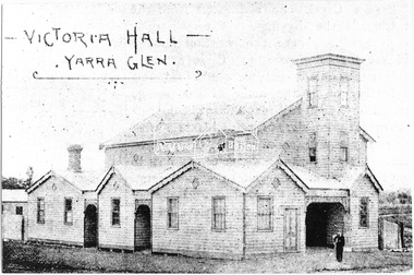
Photograph, Victoria Hall - Yarra Glen, 1893 (reproduced from "The Leader", Jan. 6th, 1894, page 31)
Source: Mrs. E.W. Motschall (nee Marjorie Smith), Long Gully Road, Panton HillThis photo forms part of a collection of photographs gathered by the Shire of Eltham for their centenary project book,"Pioneers and Painters: 100 years of the Shire of Eltham" by Alan Marshall (1971). The collection of over 500 images is held in partnership between Eltham District Historical Society and Yarra Plenty Regional Library (Eltham Library) and is now formally known as the 'The Shire of Eltham Pioneers Photograph Collection.' It is significant in being the first community sourced collection representing the places and people of the Shire's first one hundred years.Digital imagesepp, shire of eltham pioneers photograph collection, yarra glen, cave hill, steels creek -
 Eltham District Historical Society Inc
Photograph, Finish of Yarra Glen Handicap, Yarra Glen Races, 1893 (reproduced from "The Leader", Jan. 6th, 1894, page 31)
Source: Mrs. E.W. Motschall (nee Marjorie Smith), Long Gully Road, Panton HillThis photo forms part of a collection of photographs gathered by the Shire of Eltham for their centenary project book,"Pioneers and Painters: 100 years of the Shire of Eltham" by Alan Marshall (1971). The collection of over 500 images is held in partnership between Eltham District Historical Society and Yarra Plenty Regional Library (Eltham Library) and is now formally known as the 'The Shire of Eltham Pioneers Photograph Collection.' It is significant in being the first community sourced collection representing the places and people of the Shire's first one hundred years.Digital imagesepp, shire of eltham pioneers photograph collection, yarra glen, cave hill, steels creek, yarra glen races, yarra glen handicap -
 Eltham District Historical Society Inc
Photograph, Yarra Flats Hotel, Yarra Glen, 1893 (reproduced from "The Leader", Jan. 6th, 1894, page 31)
Source: Mrs. E.W. Motschall (nee Marjorie Smith), Long Gully Road, Panton HillThis photo forms part of a collection of photographs gathered by the Shire of Eltham for their centenary project book,"Pioneers and Painters: 100 years of the Shire of Eltham" by Alan Marshall (1971). The collection of over 500 images is held in partnership between Eltham District Historical Society and Yarra Plenty Regional Library (Eltham Library) and is now formally known as the 'The Shire of Eltham Pioneers Photograph Collection.' It is significant in being the first community sourced collection representing the places and people of the Shire's first one hundred years.Digital imagesepp, shire of eltham pioneers photograph collection, yarra glen, cave hill, steels creek, yarra flats hotel -
 Eltham District Historical Society Inc
Photograph, "A Coaching Party" - Hoyt & Co.'s Line, 1893 (reproduced from "The Leader", Jan. 6th, 1894, page 31)
Source: Mrs. E.W. Motschall (nee Marjorie Smith), Long Gully Road, Panton HillThis photo forms part of a collection of photographs gathered by the Shire of Eltham for their centenary project book,"Pioneers and Painters: 100 years of the Shire of Eltham" by Alan Marshall (1971). The collection of over 500 images is held in partnership between Eltham District Historical Society and Yarra Plenty Regional Library (Eltham Library) and is now formally known as the 'The Shire of Eltham Pioneers Photograph Collection.' It is significant in being the first community sourced collection representing the places and people of the Shire's first one hundred years.Digital imagesepp, shire of eltham pioneers photograph collection, yarra glen, cave hill, steels creek, hoyt & co. -
 Eltham District Historical Society Inc
Photograph, Holstein Cattle - Cave Hill, 1893 (reproduced from "The Leader", Jan. 6th, 1894, page 31)
Source: Mrs. E.W. Motschall (nee Marjorie Smith), Long Gully Road, Panton HillThis photo forms part of a collection of photographs gathered by the Shire of Eltham for their centenary project book,"Pioneers and Painters: 100 years of the Shire of Eltham" by Alan Marshall (1971). The collection of over 500 images is held in partnership between Eltham District Historical Society and Yarra Plenty Regional Library (Eltham Library) and is now formally known as the 'The Shire of Eltham Pioneers Photograph Collection.' It is significant in being the first community sourced collection representing the places and people of the Shire's first one hundred years.Digital imagesepp, shire of eltham pioneers photograph collection, yarra glen, cave hill, steels creek, holstein cattle -
 Eltham District Historical Society Inc
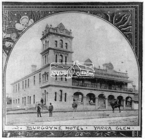
Photograph, The Leader, Burgoyne Hotel, Yarra Glen, 1893
Reproduced from "The Leader", Jan. 6th, 1894, page 31This photo forms part of a collection of photographs gathered by the Shire of Eltham for their centenary project book,"Pioneers and Painters: 100 years of the Shire of Eltham" by Alan Marshall (1971). The collection of over 500 images is held in partnership between Eltham District Historical Society and Yarra Plenty Regional Library (Eltham Library) and is now formally known as the 'The Shire of Eltham Pioneers Photograph Collection.' It is significant in being the first community sourced collection representing the places and people of the Shire's first one hundred years.Digital image 35 mm Black and White negativesepp, shire of eltham pioneers photograph collection, yarra glen, cave hill, steels creek, burgoyne hotel -
 Eltham District Historical Society Inc
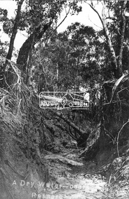
Negative - Photograph, Tom Prior, A Dry Water-course - Research, Vic, c.1895
This water course starts at Mount Pleasant Road, Research. Part of a slide show presentation "Bridges & Waterways of the Shire" by Russell Yeoman to the 13 September 1989 Society meeting. The presentation included slides of historic photos from the Shire of Eltham Pioneers collections as well as several recent views.This photo forms part of a collection of photographs gathered by the Shire of Eltham for their centenary project book,"Pioneers and Painters: 100 years of the Shire of Eltham" by Alan Marshall (1971). The collection of over 500 images is held in partnership between Eltham District Historical Society and Yarra Plenty Regional Library (Eltham Library) and is now formally known as the 'The Shire of Eltham Pioneers Photograph Collection.' It is significant in being the first community sourced collection representing the places and people of the Shire's first one hundred years. The Reynolds family were early settlers in Research. The Reynolds/ Prior collection of photographs were taken by Tom Prior, the maternal uncle of Ivy Reynolds, around 1900 and the 60 photos in the album give a fine overview of many of the landmarks of Research and Eltham over 100 years ago. lvy lived in the family home for many years at 106 Thompson Cres Research. Ivy's father, Ernst Richard Reynolds and grandfather, Richard Reynolds, lived at the same address. Ivy's father Richard worked for Mr. Trail on his property in Research. Reynolds Road is named after the family. Mr Tom Prior (wife Eva) worked at the Melbourne zoo. He was very innovative and made his own camera, using the black cloth hood to exclude the light. The photographs are a reminder of the rural nature of Research and Eltham and its rich heritage.Digital image 4 x 5 inch B&W Negshire of eltham pioneers photograph collection, research (vic.), creek, mount pleasant road, reynolds prior collection -
 Eltham District Historical Society Inc
Photograph, Marjorie North, Ansell and Muir's Chicken shop, Main Road, Eltham South, 1985-1986, 1986
Negatives supplied by Marjorie North 1 July 1986 for Montmorency France albumRoll of 35mm colour negative film, 4 of 6 stripsKodak CP 100 5094ansell, bridge, diamond creek, eltham gallery, eltham lower park, eltham park tea room, eltham south, falkiner street, muir -
 Kiewa Valley Historical Society
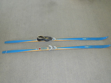
Skis Snow Competition, circa 1966
The post World War II migration of European "snow skiiers" into Australia combined with the construction of Hydo Electricity Schemes in both the N.S.W.and Victorian Alps regions, opened up these winter snow areas to a greater influx of tourists and holiday adventurers interested in "winter" sports. The ability to project, on a global scale, skiing facilities of international standards to those in the northern hemisphere during their summer has opened up the Australia ski resorts and their facilities to a much greater winter sport orientated population. These cross country skis were purchased by a member of the Bogong Ski Club and were part of a bulk ski stock consignment from Finland in 1966/67. They were introduced into the Victorian Alps to encourage skiers to take up cross country skiing both at Falls Creek and Mount Buller. This initiative spurred on the now annual 42 kilometre cross country "Kangaroo Hoppet" race at Falls Creek. This race is currently the biggest cross country snow skiing race in Australia. These snow skis were made in Finland. They are wooden (hickory) skis and made from four strips (glued and shaped) pieces of wood that are not laminated. There is a painted blue flash on the top of the skis that extends the full length of the skis. The face of the underside of the skis is flat and is coated in black Stockholm tar. Glider or grip wax was applied onto this base. The top body of the skis is tapered from shoe position to both front and back tips.Tapered curvatures from foot radiating to all sides provides the required aerodynamics. Metal boot bindings consisting of a toe plate with adjustable toe clip and a heel plate, both of which are screwed onto the skis. "KILPA, KARHU URHEILUTARPEITA SPORTART1KLAR, Karhu-Valtz Finland. Hickorypohjin"snow skiing, cross country skiing, falls creek winter tourism -
 Kiewa Valley Historical Society
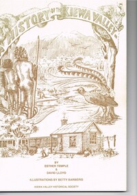
Book - A History of the Kiewa Valley, Kiewa Valley Historical Society, A History of the Kiewa Valley by Esther Temple and David Lloyd, Circa 1991
This book was compiled by Esther Temple and David Lloyd with illustrations by Betty Barberis and additional material provided by Clare Roper, Joan Macdonald, Wilma Davies and Nell Bateman. The book was first penned in 1971. It briefly covers the period from the indigenous tribes(broken down into family groupings) known as the "first Australians" who lived in the valley well before English settlers arrived. first white settlement (graziers, miners, stockmen) to smaller settlements.The development or transformation from a pristine(hunter/gatherer) valley environment to one that has been gradually changing to a more commercial rural/industrial landscaped valley. This transformation was made within a time span of two hundred years. The book details the first pioneers and their descendants, along with the changes to their environments both domestic and commercial. The book highlights dates and events that shaped the "feel" of the valley. The extreme hardships faced by pioneer families during the extremely isolated times away from "civilisation".This publication provides an insight to the struggles and victories against the harsh Australian bushland by people who had not been raised in such a sometimes inhospitable environment. It was this transformation which instilled into the Australian psyche of self sufficiency and the ability to grasp onto ideas or "bush" remedies to overcome enormous difficulties. It is is ability that has produced the many inventions useful in the 20th and 21st centuries.This book has a 250 g/m cream coloured cover with print and drawings of rural aspects of historical significance ( Aboriginal and early white settlers). The book contains 124 pages of black and white photographs(139), black and white sketches(75), two pages of sketches and freehand drawings, two freehand maps one county lease /subdivision plan and black and white printing. See KVHS 0237 (B) for the official invitation to the launch of the book.The front top cover heading(in shaded print and enclosed in a banner form) "A HISTORY OF THE KIEWA VALLEY" The bottom printing "BY ESTHER TEMPLE & DAVID LLOYD ILLUSTRATIONS BY BETTY BARBERIS" and at the very bottom "KIEWA VALLEY HISTORICAL SOCIETY" oN THE BOOK SPINE "A HISTORY OF THE KIEWA VALLEY.....BY ESTHER TEMPLE & DAVID LLOYD"early settlers, dederang, tawonga, mount beauty, sec vic hydro electricity, falls creek early settlers, bonegilla -
 Kiewa Valley Historical Society
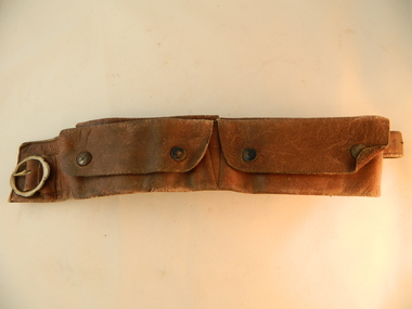
Belt Money, Circa 1950
This money, belt made of soft leather, would have been used in the mid 1900's by horse riding traders or wealthy property owners. It could also have been used by miners or other commercial business men. The main criteria for such a belt is security for valuables during travel on horseback. Commercial traders who plied their wares on horseback or caravans during a period where poor roads and flood prone rivers could dislodge wallets or money "sacks".The Kiewa Valley in the early 1900's was an environment which was frequented by the "canny" travelling salesman using dirt tracks and having to cross swollen rivers and creeks throughout the year. Travelling times within the rural areas in and surrounding the valley called for more frequent stops in bush lands. Camping presented itself with great challenges not to loose small cumbersome coin and notes. Local banks were of short supply and although bartering was a thriving method of transactions within the Valley traders from other regions were not so forth coming. Where ever possible local "trades" were called upon more than in city areas for limited products of a rural incline.This "vintage" handcrafted money belt has been professionally made circa 1950's. It appears as though it might have been made in a saddlery. There are five pockets each fastened by black painted "press studs". The stitching is of a high standard and the pockets are large and well defined. The buckle is circular with one fastening pin.handcrafts, leather work, vintage money belt, personal effects. -
 Kiewa Valley Historical Society
Black and white photograph of Surveyor's Camp, 1938, Kiewa River and surveyor's Camp 25/8/38, 25/08/1938
Surveying under the prevailing conditions at this time was an arduous and demanding task. There were no roads beyond Tawonga and access was by bridle tracks, on foot or horseback. This camp was to provide accommodation to those men who were surveying the road from South Tawonga to the Bogong High Plains which was commenced in April, 1938. The actual work was undertaken by the Country Roads Board, on behalf of the State Electricity Commission, using three Caterpillar diesel crawler tractors equipped with Kay Bruneriei (Brunner) lhydraulically operated trailbuilders (angle dozers)This photograph shows the primitive living conditions that were endured by those carrying out the initial field investigations and surveys for the Kiewa Hydro Electric Scheme. It is possibly one of the few photographs in existence of this camp and of the very rustic timber foot bridge across the West Kiewa river. It has been taken from approx. 100m up Simmonds Creek Road. A black and white photograph showing a small, timber foot bridge across the West Kiewa River. There is a man standing on the bridge and two small huts on the far side of the river, against a backdrop of Mt. Beauty and Mt. Bogong.At the top of the photograph, handwritten in black ink is the inscription "Kiewa River and Surveyor's Camp 25/8/38". The number 4 is stamped towards the right upper corner. On the back, in a circle, about 1.3cm in diameter, are the words "Kodak Print". The word "Velox" is faintly discernible on the back as well.surveyor, tawonga, west kiewa river, bridge, camp, secv -
 Eltham District Historical Society Inc
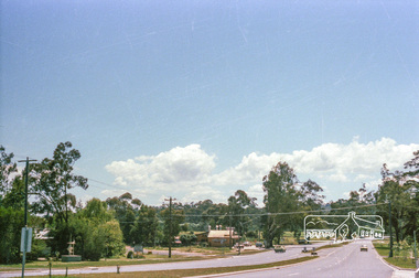
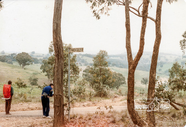
Photograph, Intersection of Spanish Gully Road and Clintons Road, Smiths Gully, c.Oct 1982, 1982
Colour photograph1982, clintons road, long gully, smiths gully, spanish gully road, watsons creek, streets -
 Eltham District Historical Society Inc
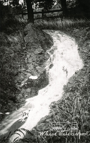
Photograph, Tom Prior, Where water's sport
Labelled by Ivy Reynolds' mother who had a good sense of humour.The Reynolds family were early settlers in Research. The Reynolds/ Prior collection of photographs were taken by Tom Prior, the maternal uncle of Ivy Reynolds, around 1900 and the 60 photos in the album give a fine overview of many of the landmarks of Research and Eltham over 100 years ago. lvy lived in the family home for many years at 106 Thompson Cres Research. Ivy's father, Ernst Richard Reynolds and grandfather, Richard Reynolds, lived at the same address. Ivy's father Richard worked for Mr. Trail on his property in Research. Reynolds Road is named after the family. Mr Tom Prior (wife Eva) worked at the Melbourne zoo. He was very innovative and made his own camera, using the black cloth hood to exclude the light. The photographs are a reminder of the rural nature of Research and Eltham and its rich heritage. Black and white photograph mounted in an album, the Reynolds/Prior Photograph Collection, this being one of 53 reproduced black and white images of early Eltham.The Reynolds/Prior Photograph Collection, Presented to the Eltham District Historical Society, 14 June 2006 by Ross McDonald. A second copy was also presented to the Andrew Ross Museum, Kangaroo Groundreynolds prior collection, creek -
 Kiewa Valley Historical Society
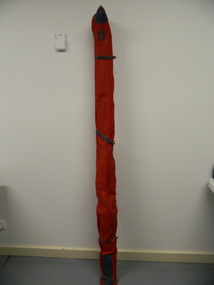
Ski Bag - snow
Used by Doug Mc Conville in the 1976 Winter Olympics. He crashed in his event.Local skier, Doug McConville skied at Falls Creek and used the skis in the 1976 Winter Olympics.Custom made red vinyl lined fabric bag with 110 cm zipper with silver stud. Blue leather reinforcing patches top and bottom. Blue leather "D" initial patch and bottomless side pocket with blue leather binding.Blue leather "D".doug mc conville. downhill skis. 1976 winter olympics. snow. -
 Kiewa Valley Historical Society
Telephone Directory - Bogong
Bogong township had a small population most of whom had a telephone as they were employees of the SEC. Also listed are the offices and works telephone numbers issued October, 1969Many residents of Bogong had moved to Mt Beauty by 1969 as had some of the offices and works so this list is of interest . It was also when calls went through the exchange(s). The exchanges were based at Mt Beauty (Terminal Station), McKay Creek, Bogong, and Mt Beauty Auto Exchange. Stiff black cardboard cover with metal fastener with 10 pages slightly yellowed. Cover has label 'Telephone' stuck on with sticky tape1st page 7 names added with blue penbogong residents, secv telephone directory, secv offices and works telephones -
 Kiewa Valley Historical Society
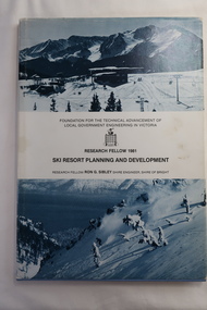
Book - Ski Resort Planning and Development, Ski Resort Planning and Development by Research Fellow Ron G. Sibley Shire Engineer, Shire of Bright
This book was published in 1981 when the Ski Industry and the Shire of Bright were proposing to expand the tourism industry.Of interest to Local Government and to those involved in the development of and activities carried out in Alpine country and ski resort areas. This research identifies the advantages and possibilities for the future.Hard light blue plain cover book with paper cover and bound spine. The paper cover has a snow photo (bluish) above and below the title. 113 pages with black and white photos and diagrams.Front page has "B.H.Goss / 37 Roper St., / Mt. Beauty 3699" stamped in top right corner.ski resort planning, ski resort development, falls creek's future, shire of bright -
 Kiewa Valley Historical Society
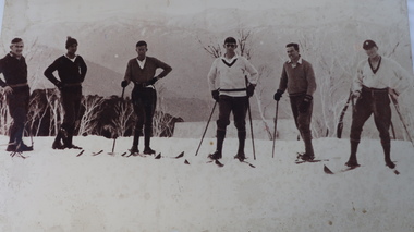
Photo - large - Group of 6 skiers
Skiing became a popular sport during the 1940s as access improved to the Bogong High Plains The Kiewa Hydro Electric Scheme was constructed on the Bogong High Plains during the 1940s and 1950s. This group of men (possibly workers on the Scheme) are back country skiing during the 1940s prior to the development of Falls Creek and downhill skiing.Large photo of a group of six male skiers with snow gums and faded mountains in the background.skiers on the bogong high plains -
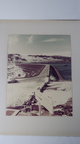 Kiewa Valley Historical Society
Photo - Rocky Valley Dam
The State Electricity Commission of Victoria constructed the Kiewa Hydro Electric Scheme on the Bogong High Plains. The scheme consisted of storage dams and pondages, aqueducts, tunnels, pipelines, transmission lines and three power stations.. Rocky Valley dam was the biggest storage and the last to be completed.Rocky Valley dam was the largest storage within the Kiewa Hydro Electric Scheme. Begun in 1954 and completed in 1960. It was linked to McKay Creek Power StationColoured photo attached to cream cardboard. The background shows hills and the foreground a sign "Rocky Valley Dam ..." The middle shows the dam with water and its bank. There is snow on the ground.rocky valley dam, kiewa hydro electric scheme, secv -
 Kiewa Valley Historical Society
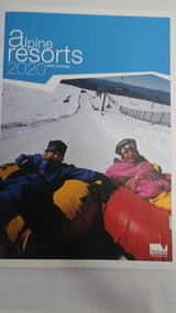
Book - Alpine Resorts - 2020 draft strategy, Alpine Resorts 2020 draft strategy
This is a commissioned report auspiced by the State Government of Victoria - Department of Sustainability and Environment 2003.This report was prepared to guide the sustainable long-term planning and management of Victoria's six Alpine Resorts. Falls Creek, Lake Mountain, Mount Baw Baw, Mount Buller, Mount Hotham and Mount Stirling, after the catastrophic bush fires of 2002- 2003.Colorured cardboard front cover with two people on air mattresses in foreground. Title white on bue top left corner. 40 glossy thick paper/card pages. A4Logo "Victoria / The Place to betourism in alpine resorts, sustainability and environment, victorian government, 2002-2003 bushfires -
 Kiewa Valley Historical Society
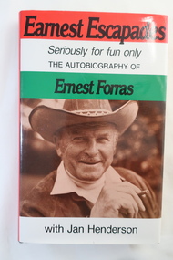
Book - The Autobiography of Ernest Forras, Earnest Escapades Seriously for fun only The autobiography of Ernest Forras with Jan Henderson
Ernest migrated from Hungary in January 1951 and helped bring commercial development to Australia's fledgling snowfields. He was keen to find Alpine employment, eventually importing ski and sports gear. This book covers his time in Hungary and his visits to the Alpine Ski Resorts - an insight into the early years of skiing in Australia.Ernest visited Falls Creek on the Bogong High Plains in 1951 and describes the area on pages 66 to76 from the point of view of an Hungarian migrant. He visited Falls Creek because his brother had got work on Kiewa Hydro Electric Ssheme.Hard dark brown cover book with dust cover coloured in red, white and green with title in black and a photo of Ernest Forras below. It consists of 190 pages. After page 54 and between Part one and Two, there are 18 pages of photos on photographic paper.Written in shaky writing on inside first page "To Debbie / From Hungary With Love / Ernest Forras 2002 / Mt Beautyernest forras, australian ski resorts from 1951, hungary pre 1951 -
 Kiewa Valley Historical Society
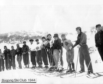
Photos: Skiers at Falls Creek x2 copies
Bogong Ski ClubBogong Ski Club - SECV employeesBlack and white photo of 14 skiers from Bogong Ski Club 1944bogong ski club