Showing 1401 items
matching 1863
-
![Cr. G.O.S. Greer J.P., Mayor [of Kew] 1964-5](/media/collectors/550653872162f11fb04854aa/items/5922bfbbd0cde9131c3505c1/item-media/5c19e4b321ea6f0a58c9d403/item-fit-380x285.jpg) Kew Historical Society Inc
Kew Historical Society IncPhotograph, Stuart Tompkins Studio, Cr. G.O.S. Greer J.P., Mayor [of Kew] 1964-5, 1964
Kew achieved independence from the Boroondara Roads Board in 1860. As a new municipality, its first three leaders were designated as chairmen. On becoming a borough in 1863, its leaders were identified as mayors. The earliest photographs date from ca.1906, when the Town of Kew commissioned the noted local photographer Josiah E Barnes to produce standardised portraits of former mayors to be displayed in the Mayoral Chamber of the Town Hall. The collection also includes photographs by other well-known photographic studios such as Burlington Studios, Melba – Melbourne, Stuart Tompkins, Spencer Shier and Talma & Co. The majority of mounts identify the photographer. Eighty photographs are housed in their original frames.This portrait is one of a series of mounted and framed photographic portraits of Mayors and Town Clerks of the former Borough, Town and City of Kew, for the period 1863 to 1969. The portraits were transferred by the City of Kew to the Kew Historical Society in March 1989. A Significance Assessment in 2018, funded by the National Library of Australia confirmed the historic, and often artistic significance of the series. Framed portrait of Cr. G. O. S. Greer J.P., Mayor of Kew 1964-5. The mounting and framing of the photograph follows a typical layout or style in that each is framed in dark wood, glazed, and laid down on an inscribed board. The inscription identifies the name of the mayor and the year/s that he/she served.Cr. G.O.S. Greer J.P. / Mayor 1964-5 Stuart Tompkins Studiomayors of kew (vic), cr. g. o. s. greer, australian photographers - stuart tompkins studio, kew (vic.) — municipal collection -
![Cr. A. G. Grace J.P., Mayor [of Kew] 1965-6](/media/collectors/550653872162f11fb04854aa/items/5922bfd4d0cde9131c35166c/item-media/5c19e2c521ea6e0a58dc013f/item-fit-380x285.jpg) Kew Historical Society Inc
Kew Historical Society IncPhotograph, Cr. A. G. Grace J.P., Mayor [of Kew] 1965-6, 1965
Kew achieved independence from the Boroondara Roads Board in 1860. As a new municipality, its first three leaders were designated as chairmen. On becoming a borough in 1863, its leaders were identified as mayors. The earliest photographs date from ca.1906, when the Town of Kew commissioned the noted local photographer Josiah E Barnes to produce standardised portraits of former mayors to be displayed in the Mayoral Chamber of the Town Hall. The collection also includes photographs by other well-known photographic studios such as Burlington Studios, Melba – Melbourne, Stuart Tompkins, Spencer Shier and Talma & Co. The majority of mounts identify the photographer. Eighty photographs are housed in their original frames.This portrait is one of a series of mounted and framed photographic portraits of Mayors and Town Clerks of the former Borough, Town and City of Kew, for the period 1863 to 1969. The portraits were transferred by the City of Kew to the Kew Historical Society in March 1989. A Significance Assessment in 2018, funded by the National Library of Australia confirmed the historic, and often artistic significance of the series. Framed portrait of Cr. A. G. Grace J.P., Mayor of Kew 1965-6. The mounting and framing of the photograph follows a typical layout or style in that each is framed in dark wood, glazed, and laid down on an inscribed board. The inscription identifies the name of the mayor and the year/s that he/she served.Cr. A. G. Grace J.P. / Mayor 1965-6 Stuart Tompkins Studiocr. a. g. grace j.p., mayors of kew (vic), australian photographers - stuart tompkins (studio), kew (vic.) — municipal collection -
![Cr. G. P. Mackenzie LL.B., J.P., Mayor [of Kew] 1966-67](/media/collectors/550653872162f11fb04854aa/items/5922bfedd0cde9131c3528fe/item-media/5c19e14721ea6d0a58d0ce0c/item-fit-380x285.jpg) Kew Historical Society Inc
Kew Historical Society IncPhotograph, Cr. G. P. Mackenzie LL.B., J.P., Mayor [of Kew] 1966-67, 1966
Kew achieved independence from the Boroondara Roads Board in 1860. As a new municipality, its first three leaders were designated as chairmen. On becoming a borough in 1863, its leaders were identified as mayors. The earliest photographs date from ca.1906, when the Town of Kew commissioned the noted local photographer Josiah E Barnes to produce standardised portraits of former mayors to be displayed in the Mayoral Chamber of the Town Hall. The collection also includes photographs by other well-known photographic studios such as Burlington Studios, Melba – Melbourne, Stuart Tompkins, Spencer Shier and Talma & Co. The majority of mounts identify the photographer. Eighty photographs are housed in their original frames.This portrait is one of a series of mounted and framed photographic portraits of Mayors and Town Clerks of the former Borough, Town and City of Kew, for the period 1863 to 1969. The portraits were transferred by the City of Kew to the Kew Historical Society in March 1989. A Significance Assessment in 2018, funded by the National Library of Australia confirmed the historic, and often artistic significance of the series. Framed portrait of Cr. G. P. Mackenzie, Mayor of Kew 1966-7. The mounting and framing of the photograph follows a typical layout or style in that each is framed in dark wood, glazed, and laid down on an inscribed board. The inscription identifies the name of the mayor and the year/s that he/she served.Cr. G. P. Mackenzie LL.B., J.P. / Mayor 1966-67cr. g. p. mackenzie, mayors of kew (vic), kew (vic.) — municipal collection -
![Cr. H. E. Wiltshire J.P., Mayor [of Kew] 1968-69](/media/collectors/550653872162f11fb04854aa/items/5922c003d0cde9131c353865/item-media/5c19dd6521ea6b0a589ccde0/item-fit-380x285.jpg) Kew Historical Society Inc
Kew Historical Society IncPhotograph, Cr. H. E. Wiltshire J.P., Mayor [of Kew] 1968-69, ca.1969
Kew achieved independence from the Boroondara Roads Board in 1860. As a new municipality, its first three leaders were designated as chairmen. On becoming a borough in 1863, its leaders were identified as mayors. The earliest photographs date from ca.1906, when the Town of Kew commissioned the noted local photographer Josiah E Barnes to produce standardised portraits of former mayors to be displayed in the Mayoral Chamber of the Town Hall. The collection also includes photographs by other well-known photographic studios such as Burlington Studios, Melba – Melbourne, Stuart Tompkins, Spencer Shier and Talma & Co. The majority of mounts identify the photographer. Eighty photographs are housed in their original frames.This portrait is one of a series of mounted and framed photographic portraits of Mayors and Town Clerks of the former Borough, Town and City of Kew, for the period 1863 to 1969. The portraits were transferred by the City of Kew to the Kew Historical Society in March 1989. A Significance Assessment in 2018, funded by the National Library of Australia confirmed the historic, and often artistic significance of the series. Framed portrait of Cr. H. E. Wiltshire J.P., Mayor of Kew during 1968-9. The mounting and framing of the photograph follows a typical layout or style in that each is framed in dark wood, glazed, and laid down on an inscribed board. The inscription identifies the name of the mayor and the year/s that he/she served.Cr. H. E. Wiltshire J.P., / Mayor 1968-69mayor of kew, cr. h. e. wiltshire, kew -- municipal collection -
 Wodonga & District Historical Society Inc
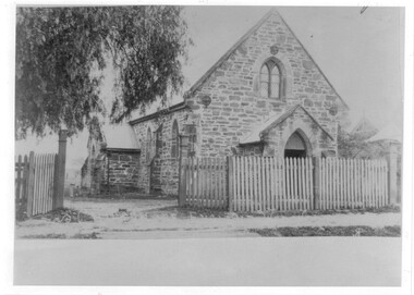
Photograph - St Luke's Church, Wodonga
St Luke’s Anglican Church officially opened on 15 March 1863 and originally operated as a branch of the Albury church. The first minister to conduct a service there was Rev. Robert Potter, followed by Rev. B. Brownrigg , Rev. J. H. May, Rev. D. E. Jones and Rev. J. K. Tucker. The first resident minister at Wodonga was Rev. J. H. White who came in 1879. The Church was constructed from locally hewn stone. After serving the congregation for more than a century, the Church was closed by the Health Commission due to its deteriorated condition which was judged to be beyond repair. It was demolished by voluntary labour on the 10 – 11 August 1968. A collection of 4 black and white photos depicting St. Luke's Church Wodonga at different times in its development.st luke's church wodonga, churches wodonga, early churches wodonga -
 Buda Historic Home & Garden Castlemaine
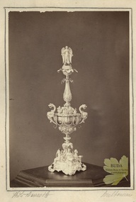
Photograph, Leviny Silver Standing Cup, c1863
The Silver Standing Cup was made by Ernest Leviny c1860 and presented to Mr Charles Abraham Saint, editor of the Mount Alexander Mail newspaper, by the town's citizens on his departure from Castlemaine on 31 December 1863. Mount Alexander Mail report; 23 January 1864. This substantial silver centrepiece was the second masterpiece created by Ernest Leviny around 1859. It is decorated with highly detailed cast figures, fine embossing and chasing. This work of Australian Colonial significance reflects Leviny's rich European artistic background which he successfully merged with new Australian motifs, which epitomise the great wealth, ambition and pride at that time in the emerging, young Colony of Victoria.Semi matt surface albumen print mounted on cream coloured card with border around image drawn in pencil. Albumen photograph of Silver Standing Cup (Eperne). Elaborate silver cup, with lid highly decorated with cast figures, etc.Handwritten in pencil under image: I.1 'Photo Davies & Co' I.r 'Melbourneernest leviny, silver, silversmithing, cup, london exhibition 1862, mount alexander mail, william davies, photograph, charles a. saint -
 Linton and District Historical Society Inc
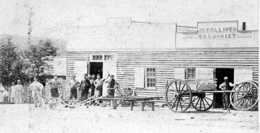
Photograph, J.G. Colliver, Machinist Workshop, 1902, 1902
James Garland Colliver lived and worked in Linton between 1863 and 1875, when he moved to Donald. He was actively involved in Linton's business and community life. (See Colliver family file at LDHS.) This photograph may show two adjacent business premises on the east side of Sussex Street, north of Clyde Street: Edwin Ball or Ball Brothers, blacksmiths, and J.G. Colliver, "Machinist". The Ball and Colliver families were related and are understood to have worked collaboratively. A plan of Sussex Street drawn up in 1871 (in LDHS collection -Reg. no. 2013-25) shows an allotment on the east side owned by 'Colliver' next to a slightly larger allotment owned by 'Ball'.Original small, sepia photograph showing premises of "J G Colliver - Machinist" with workmen in front."J G Collivers shop about 100 years ago".j. g. colliver, wheelwright, carpenter, coachbuilder, workers -
 Mortlake and District Historical Society
Mt. Shadwell Bush Inn, photograph
This Mount Shadwell Bush Inn erected in 1854 was situated adjacent to one of the main routes to the diggings (Great Western Road), and was originally built from tufa stone obtained from a local quarry. It did a great trade after if first became licensed ub 1855, when it provided a valuable service to the travelling public and to the increasing agricultural population of the area. At that time it contained three sitting rooms, several large reception rooms, fourteen bedrooms, a bar and two taprooms and was the first known hostelry in Mortlake. In 1863 a bluestone addition (probably done by local architect Andrew Kerr) increased the size of the hotel to 23 rooms with a detached billiard room and ballroom, kitchen, servant's apartments, laundry, storeroom, 12 stalled stable, out office, and stock yards for travelling cattle. The present hotel with its 1928 rendered facade, has had an almost uninterrupted licence since 1855 -
 Bendigo Historical Society Inc.
Document - PRINTED NOTE PAD FOR LAND VALUATION
Note pad. Eleven blank land valuation worksheets for the Land Commission. Each valuation comprises 3 separate pages to record Lessee's and Commission's improvements plus stock, implements and other assets. Some of these pages have been used to record other items not related to the above. Handwritten in ink as follows. (1) Royal Historical Society of Victoria - notes on general index codes. (2) Snobs Hill Rovers football club 1904 - some 50 names. (3) Officers and members of the Hopetoun Brass Band, Bendigo as at 14 Feb 1913 - Name No.473 is Sir John Quick. Name No. 497 is J. Michell, bandmaster. Ends at Name No.522. (4) Eaglehawk Pioneers - Name nos.523 to 618. Each name has a year beside it ranging from 1846 ? (J.Mouatt) to 1863. (5) One page list of Regional Parishes each with a date and number, (crossed out in pencil).Land Commission ?government, state, land commission, valuation notepad, snobs hill rovers football club, hopetoun brass band, eaglehawk pioneers, regional parishes, index codes for royal historical society of victoria -
 Kew Historical Society Inc
Plan - Subdivision Plan, J R Mathers & McMillan, Clutha Subdivision, 1940
Pru Sanderson, in her groundbreaking ‘City of Kew Urban Conservation Study : Volume 2 - Development History’ (1988), summarised the periods of urban development and subdivisions of land in Kew. The periods that she identified included 1845-1880, 1880-1893, 1893-1921, 1921-1933, 1933-1943, and Post-War Development. These periods were selected as they represented periods of rapid growth or decline in urban development. An obvious starting point for Sanderson’s groupings involved population growth and the associated economic cycles. These cycles also highlighted urban expansion onto land that was predominantly rural, although in other cases it represented the decline and breakup of large estates. A number of the plans in the Kew Historical Society’s collection can also be found in other collections, such as those of the State Library of Victoria and the Boroondara Library Service. A number are however unique to the collection.The Kew Historical Society collection includes almost 100 subdivision plans pertaining to suburbs of the City of Melbourne. Most of these are of Kew, Kew East or Studley Park, although a smaller number are plans of Camberwell, Deepdene, Balwyn and Hawthorn. It is believed that the majority of the plans were gifted to the Society by persons connected with the real estate firm - J. R. Mathers and McMillan, 136 Cotham Road, Kew. The Plans in the collection are rarely in pristine form, being working plans on which the agent would write notes and record lots sold and the prices of these. The subdivision plans are historically significant examples of the growth of urban Melbourne from the beginning of the 20th Century up until the 1980s. A number of the plans are double-sided and often include a photograph on the reverse. A number of the latter are by noted photographers such as J.E. Barnes.The subdivision plan for the Clutha Subdivision is one of the largest in the Society’s collection. The plan includes a map of the proposed allotments, photographic views to the north and south, and information about the kinds of buildings that could be constructed on the allotments. The subdivision was bounded by Studley Park Road, and Carson, Stevenson and Edgecombe Streets. Two new streets, Mackie Court and Younger Street were created as part of the subdivision. The subdivision took its name from ‘Clutha’, the home of John Carson, who was to become Mayor of Kew in 1863. A Report to the City of Boroondara outlined how: ‘The Clutha estate was progressively developed from 1940, with new houses under construction on the Studley Park Road, Carson and Edgecombe Street frontages by 1941. By 1943, directory listings were available for all addresses with the exception of Mackie Court. Building ceased after the government’s prohibition on civilian building was enforced from 1942, with little change in listings until the 1950s when the remainder of the subdivision was developed’."H"subdivisions - kew - studley park, clutha subdivision, studley park road -
 Creswick Museum
Model Building, circa 1869
Rev. Thomas Williams was grandfather of the Lindsay children. He is credited with encouraging his grandchildren in their artistic talents. Both Lionel and Normam learnt their model making skills from him. Creswick Hospital was foundation stone was laid in 1863. It operated as a hospital until 1911 when it was sold to the government as part of the School of Forestry (now University of Melbourne). The model shows it as a red brick building. In the 1870s it was painted as a white building. The Museum has b/w photos of the building taken prior to rendering. The people of Creswick collected fund for the project and obtained a government grant. The 1857 survey map of the proposed township shows the area at Eastern Hills reserved for a hospital and Benevolent SocietyThe model's unique association with the Lindsay Artist of Creswick. Model of Creswick Hospital before rendering. Made of paper with painted background and framed.model, creswick hospital, rev t. williams, lindsay family -
 Uniting Church Archives - Synod of Victoria
Printed etching, Undated c.1858
Rev William Butters (1810 - 1887). Born Hibbaldstone, Lincolnshire on 24 January 1810. Entered the Wesleyan ministry in 1833 and sent as a missionary to Van Dieman's Land. Worked with convicts at Port Arthur, then served at Hobart, Ross and Launceston. In 1850 he was appointed to Melbourne. His health failed during the unprecedented difficulties initiated by the discovery of gold in 1851. Appointed to Adelaide 1855 - 1862. returned to Victoria in 1862, but his health broke down completely and he returned to England in 1863 and became a supernumerary. A founder of the Wesleyan Mission Carlton. President of the Australasian Conference in 1858. William Butters lived for 24 years in the London (Brixton) circuit before dying suddenly on 10 October 1887.B & W waist length printed etching of Rev. William Butters"Revd William Butters President of the Australasian Conference"william butters, wesleyan, methodist, minister, chaplain, port arthur, van dieman's land, wesleyan mission carlton, president of conference -
 Kew Historical Society Inc
Photograph, Floods in North Kew, 1971
Living with natural processes was frequently a challenge to early European settlers and later residents of what was in the 1850s administered by the Borondara Road Board. This was compounded by the area being bounded on three sides by rivers (Yarra River, Koonung Creek and Gardiner's Creek). In 1849, the historian James Bonwick recorded that "our district [Kew] suffered considerably. Mr Wade speaks of 80 acres, out of 100 acres of his cultivated paddock, covered by water." Newspapers continued to describe major flooding in Kew in 1863, 1869, 1878, 1880, 1889, 1891, 1916 and 1934. While the construction of the Upper Yarra dam in 1957 reduced the levels of flowing downstream, local and riverine floods continue.The Kew Historical Society's pictures and map collections testify to the impact of flooding in the district. They have historical importance in documenting the extent of flooding in the district and its affects on homes, services and recreation. Numerous photographs record flooding throughout the Twentieth Century.Floods in North Kew, 1971. Looking northeast towards Kilby Road from River Avenue. Annotation on reverse: map and date "8 Nov. 71 10.30am".floods (kew), yarra river, kew flood, kilby road flood -
 Kew Historical Society Inc
Photograph, Floods in North Kew, 1934
Living with natural processes was frequently a challenge to early European settlers and later residents of what was in the 1850s administered by the Borondara Road Board. This was compounded by the area being bounded on three sides by rivers (Yarra River, Koonung Creek and Gardiner's Creek). In 1849, the historian James Bonwick recorded that "our district [Kew] suffered considerably. Mr Wade speaks of 80 acres, out of 100 acres of his cultivated paddock, covered by water." Newspapers continued to describe major flooding in Kew in 1863, 1869, 1878, 1880, 1889, 1891, 1916 and 1934. While the construction of the Upper Yarra dam in 1957 reduced the levels of flowing downstream, local and riverine floods continue.The Kew Historical Society's pictures and map collections testify to the impact of flooding in the district. They have historical importance in documenting the extent of flooding in the district and its affects on homes, services and recreation. Numerous photographs record flooding throughout the Twentieth Century.Floods in North Kew, 1934. Vicinity of Willsmere Park.floods (kew) -
![Flooding at Chipperfield's Boathouse [East Kew], 1934](/media/collectors/550653872162f11fb04854aa/items/58cbaad5d0cec425b474bfb1/item-media/58cf6fbdd0cf9f331490feb0/item-fit-380x285.jpg) Kew Historical Society Inc
Kew Historical Society IncPhotograph, Flooding at Chipperfield's Boathouse, 1934
Living with natural processes was frequently a challenge to early European settlers and later residents of what was in the 1850s administered by the Borondara Road Board. This was compounded by the area being bounded on three sides by rivers (Yarra River, Koonung Creek and Gardiner's Creek). In 1849, the historian James Bonwick recorded that "our district [Kew] suffered considerably. Mr Wade speaks of 80 acres, out of 100 acres of his cultivated paddock, covered by water." Newspapers continued to describe major flooding in Kew in 1863, 1869, 1878, 1880, 1889, 1891, 1916 and 1934. While the construction of the Upper Yarra dam in 1957 reduced the levels of flowing downstream, local and riverine floods continue.The Kew Historical Society's pictures and map collections testify to the impact of flooding in the district. They have historical importance in documenting the extent of flooding in the district and its affects on homes, services and recreation. Numerous photographs record flooding throughout the Twentieth Century.Floods in North Kew, 1934. Chipperfield's Boathouse and the adding Moorings was located beside the Yarra River near the corner of Willsmere and Kilby Roads. The flood reached the roof of the Moorings, which can be seen in the photo.floods (kew), floods (kew) 1934, yarra river -
 Kew Historical Society Inc
Photograph, Floods in North Kew, 1934
Living with natural processes was frequently a challenge to early European settlers and later residents of what was in the 1850s administered by the Borondara Road Board. This was compounded by the area being bounded on three sides by rivers (Yarra River, Koonung Creek and Gardiner's Creek). In 1849, the historian James Bonwick recorded that "our district [Kew] suffered considerably. Mr Wade speaks of 80 acres, out of 100 acres of his cultivated paddock, covered by water." Newspapers continued to describe major flooding in Kew in 1863, 1869, 1878, 1880, 1889, 1891, 1916 and 1934. While the construction of the Upper Yarra dam in 1957 reduced the levels of flowing downstream, local and riverine floods continue.The Kew Historical Society's pictures and map collections testify to the impact of flooding in the district. They have historical importance in documenting the extent of flooding in the district and its affects on homes, services and recreation. Numerous photographs record flooding throughout the Twentieth Century.Floods in North Kew, 1934. Unidentified location on the Yarra Flood Plain at Kew.floods (kew) 1934, yarra river -
 Kew Historical Society Inc
Photograph, Floods in North Kew, 1934
Living with natural processes was frequently a challenge to early European settlers and later residents of what was in the 1850s administered by the Borondara Road Board. This was compounded by the area being bounded on three sides by rivers (Yarra River, Koonung Creek and Gardiner's Creek). In 1849, the historian James Bonwick recorded that "our district [Kew] suffered considerably. Mr Wade speaks of 80 acres, out of 100 acres of his cultivated paddock, covered by water." Newspapers continued to describe major flooding in Kew in 1863, 1869, 1878, 1880, 1889, 1891, 1916 and 1934. While the construction of the Upper Yarra dam in 1957 reduced the levels of flowing downstream, local and riverine floods continue.The Kew Historical Society's pictures and map collections testify to the impact of flooding in the district. They have historical importance in documenting the extent of flooding in the district and its affects on homes, services and recreation. Numerous photographs record flooding throughout the Twentieth Century.Floods in North Kew, 1934. Chipperfield's Boat House under flood.floods (kew) 1934, yarra river, chipperfield's boat house -
 Kew Historical Society Inc
Photograph, Floods in North Kew, 1934
Living with natural processes was frequently a challenge to early European settlers and later residents of what was in the 1850s administered by the Borondara Road Board. This was compounded by the area being bounded on three sides by rivers (Yarra River, Koonung Creek and Gardiner's Creek). In 1849, the historian James Bonwick recorded that "our district [Kew] suffered considerably. Mr Wade speaks of 80 acres, out of 100 acres of his cultivated paddock, covered by water." Newspapers continued to describe major flooding in Kew in 1863, 1869, 1878, 1880, 1889, 1891, 1916 and 1934. While the construction of the Upper Yarra dam in 1957 reduced the levels of flowing downstream, local and riverine floods continue.The Kew Historical Society's pictures and map collections testify to the impact of flooding in the district. They have historical importance in documenting the extent of flooding in the district and its affects on homes, services and recreation. Numerous photographs record flooding throughout the Twentieth Century.Floods in North Kew, 1934. Flood near the lagoon (Billabong?)floods (kew) 1934, yarra river -
 Surrey Hills Historical Society Collection
Photograph, Mr A Noack, Emilia Villa, 4 Albany Crescent, Surrey Hills, 1984
The house was built in 1913 for Mr James Rubira and named for his wife Emilia Tajouera Guidotti, an Italian opera singer. She was born in 1865 and died in Surrey Hills on 21 October 1950. James was born in 1863 in Allela, Barcelona, Catalonia, Spain and died on 8 November 1935 in Surrey Hills. They married in Victoria in 1892. They married in 1892. James's mother was a member of the Parer family. The Rubiras and the Parers were among a number of Spanish families who began to migrate to Australia in the 1860s. James' mother was Teresa Florentina Lluisa Parer. Many of the families settled in Box Hill and then Surrey Hills by the 1900s. The Rubiras and the Parers established and supplied a number of high-class restaurants and hotels in Melbourne.Coloured image of an Edwardian style brick house at 4 Albany Crescent, Surrey Hills. It shows the path up to the house with the garden on each side. There is a fountain in the garden on the LHS of the path.On rear in blue pen: "Mr Rubira's House / per / A Noack (underlined) / Albany Cres"emilia villa, house names, 1913, singers, spanish community, italian community, ethnic communities, parer family, albany crescent, surrey hills, restaurants, hotels, edwardian style, mr james rubira, mrs emilia rubira, miss emilia tajouera guidotti -
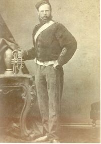 Port Fairy Historical Society Museum and Archives
Photograph, Bowyer, Samuel
Samuel came to Belfast with his parents Benjamin and Maryanne on the ship 'Oithona' arriving at Portland on January 30th 1855 when he was 11 years old. In 1865 he marries Selina Ann Daughter of William and Mary Oaff who arrived in Australia on the 'Clara' on the same day as Samuel. They had 6 children. As a stonemason by trade It is probable that he helped his father build the wall around the Consolidated school in 1875. They lived in a stone cottage next door to the Port Fairy Hospital. It was demolished when the new wing was built in 1976. He joined the Manchester Order of Oddfellows in 1863 and was elected Grand Master in 1880. He died when he was 37 in 1881.Early settlerPosed portrait black & white photographpioneer, settler, portrait, people, family, bowyer, samuel, stonemason, clara, oithona, selina ann, william oaff, mary oaff -
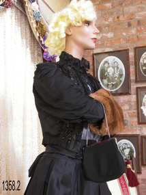 Flagstaff Hill Maritime Museum and Village
Clothing - Blouse and Belt, mid-to-late 19th century
This handmade blouse with its matching belt was donated along with a note that says, "This jacket was owned by Marion Leishman who married Captain Eadie. They lived in Warrnambool and are buried at Tower Hill Cemetery." The spelling on the headstone is "Edie" rather than "Eadie". Marion Leishman Edie was born in 1835 and died on August 7, 1914. She married Captain Richard Wilson C Edie in 1865. Capt. Edie drowned at sea on 16th June 1883 aged 49 years. Marion Leishman Edie died on 7th August 1914 aged 79 years. Her sister Alison Keishman Sprod, died in 1863, aged 25 years, and is also buried in the same grave at Tower Hill. The fine satin blouse and matching belt is an example of clothing worn by women in the mid-to-late 19th century. It demonstrates the beautiful and talented skills applied to handmade garments. The decoration indicates that the blouse or jacket was worn for a special occasion.Blouse of black satin, decorated with lace and sequins. Long sleeves are puffed at the shoulder fitted at the lower arm and cuff. The belt has sequins and tassels. Black lace is added around the neck and bodice, fastened at the front with hook and eye.flagstaff hill, warrnambool, shipwrecked-coast, flagstaff-hill, flagstaff-hill-maritime-museum, maritime-museum, shipwreck-coast, flagstaff-hill-maritime-village, costume, blouse, belt, female adult, clothing, fashion, satin, lace, wonem's clothing, marion leishman, captain eadie, tower hill cemetery, marion eadie, jacket, black satin jacket, sequins, marion edie, richard wilson c edie, drowned at sea, marion leishman edie, handmade, black jacket, sequined satin jacket -
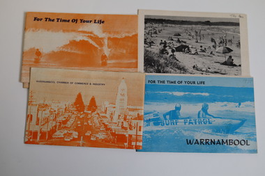 Warrnambool and District Historical Society Inc.
Booklet - Warrnambool Tourist Guides (5), Warrnambool Chamber of Commerce and Industry, Warrnambool - For the Time of Your Life, 1970-1975
Warrnambool Tourist Guides 1970-1975.1,.2,.3 - These are booklets of 36 pages with an orange cover with an illustration of two people on surf boards on the front cover and an image of a main street on the back cover. The cover has blue printing. The pages contain a map, advertisements, black and white photographs and printed text. One booklet is stapled and two have the staples removed. .4,.5 -These are booklets of 40 pages with a front cover with a photograph in blue tones of a surf patrol boat and two lifesavers and a back cover with a black and white photograph (beach scene). The pages contain a map, advertisements, black and white photographs and printed text. One booklet is stapled and one has the staples removed. non-fictionWarrnambool Tourist Guides 1970-1975warrnambool tourism, tourism in warrnambool in the 1970s -
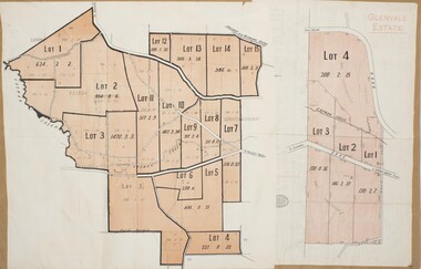 Bacchus Marsh & District Historical Society
Map, Glenvale Estate and Glenmore Estate Land Sales 1909
The two land auction plans shown in this record relate to the sale of land from the Glenmore Estate property. The Glenmore property was established by C.J. (Charles James) Griffith and James Moore around 1840. Moore sold his interest to Moelesworth Greene in 1848. Greene was the nephew of the other owner Charles Griffith who died in 1863. From around the 1870s onwards parts of the Estate were subdivided and put up for sale or lease. In subsequent decades more changes in ownership occurred. These two plans document another major sale of the land from the original Glenmore Estate including part of the estate which had become used for dairy farming and was at that time known as the Glenvale Estate. Two single page maps pasted together on a single page of a bound volume of maps. One map shows 15 separate lots of land for sale. The other map which has the words 'Glenvale Estate' at the top of the map shows 4 lots of land for sale. Both parcels of land were originally part of the Glenmore Estate a pastoral holding belonging to C.J. Griffith and James Moore which the began in the Rowsley area south west of Bacchus Marsh in the 1840s. The maps are pasted into a bound volume containing 76 maps or plans in total. High resolution digital image stored on BMDHS computer network. bacchus marsh victoria maps, glenvale estate property, glenvale estate land sales, glenmore estate, glenmore station -
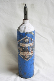 Geoffrey Kaye Museum of Anaesthetic History
Equipment - Cylinder, Nitrous Oxide
Nitrous oxide has been used for anaesthesia in dentistry since December 1844, where Horace Wells made the first 12–15 dental operations with the gas in Hartford. Its debut as a generally accepted method, however, came in 1863, when Gardner Quincy Colton introduced it more broadly at all the Colton Dental Association clinics, that he founded in New Haven and New York City. Hospitals administer nitrous oxide as one of the anaesthetic drugs delivered by anaesthetic machines. Nitrous oxide is a weak general anaesthetic, and so is generally not used alone in general anaesthesia. In general anaesthesia it is used as a carrier gas with oxygen for more powerful general anaesthetic drugs.Medium size empty blue coloured cylinder with rounded base and painted white neck once containing Nitrous Oxide. A large blue on white diamond shaped label is adhered onto the main cylinder body.Printed on manufacturer's label: 'CIG [logo] / [blank weights table] / DRY / NITROUS OXIDE / C.I.G. (Victoria) PTY. LTD. / 50 LA TROBE STREET, MELBOURNE C3 / Telephones: FJ 6681 / FJ 4164 / USE NO OIL / OR GREASE'nitrous oxide, dental anaesthesia, dental anesthesia, gardner quincy colton, colton dental association -
 Eltham District Historical Society Inc
Film - Video (DVD), Melbourne and Metropolitan Board of Works, Yarra River Conference Proceedings; a Board of Works centenary event, 13-16 April 1991
Yarra River Conference History Segment [Noted on VHS tape jackets "Due to unavoidable circumstances, the quality of these tapes in some setions is less than desired."] The Yarra River Conference, organised by the Board of Works as part of the Centenary Celebrations, was held in the Board's Head Office Theatrette from 13-16 April, 1991. A segment of the Conference focussed on the role that the Yarra River has played in relation to the historical development of Melbourne. Conceived and presented by a group of prominent historians as a chronological 'trip down the river in time', and profusely illustrated with slides, this segment traced the various impacts that urban and rural growth, development of marine commerce, recreational uses, and environmental problems have had on the Yarra during a century and a half of European occupation. As no formal written paper of this combined presentation is available, these two video-tapes provide a record for anyone who has an interest in tis fascinating aspect of the Yarra's history. The speakers who combined to present this segment are identified on the cover of Tape 2. Tape 1 (2 hours) 1838-1863 Deputy ?? to Utility Early navigators of the Yarra River; developing the port of Melbourne; the gold rush and its effect on the new colony; punts and bridges; water supply; pollution of the Yarra; the discovery of gold and early settlement of the Yarra valley; floods of 1839 and 1863. 1863-1891 Formation of the Harbour Trust; Coode Canal; pollution of the Yarra by industry; aborigines, gold miners, timber getters in the Upper Yarra areas; bridges; the flood of 1891. Tape 2 ( 1 1/2 hours) 1892-1934: People Begin to See Beauty and Romance to the River Henley-on-Yarra; realignment of the Yarra; MMBW is responsible for a sewerage system; new docks to cope with increased overseas trade; development of recreational parks; new reservoirs; timber production and timber tramways; bushfire; flood of 1934. 1935-1970: The River is Neglected Still, Except When it Proves Useful Bushfirs of 1939; the end of many sawmills; birth of tourism; increased interest in conservation and preservation of land for open space; further augmentation of water supply system; birth of containerisation changes the port; environmental concerns gain momentum. Speakers Dr Tony Dingle *, Department of Economic History, Monash University Dr Carolyn Rasmussen *, History Consultant Prof. Graeme Davison, History Department, Monash University Mr. Tom Griffiths, Lecturer in Public History, Monash Uiversity Mr. Patrick Miller, History Consultant Mr. Colin Jones, Author and Historian * Co-authors of the Board's history, 'Vital Connections'.video recording, yarra river, conference proceedings -
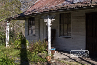 Eltham District Historical Society Inc
Photograph, Fred Mitchell, Jarrold Cottage, 5 September 2007
Three historically significant buildings are here at 701 Main Road, opposite Dalton Street, Eltham. Jarrold Cottage or White Cloud was built about 1863 and remains one of the oldest buildings in Eltham. It was once used temporarily as Eltham’s first police station. The Jarrolds were a pioneer family of market gardeners and building tradesmen over six decades and from the early 1940s, with the Skippers and other prominent local figures involved in the construction and development of the Montsalvat Artists' Colony. Len Jarrold, a carpenter, worked at Montsalvat from the beginning and became foreman of works for the splendid 1938 Great Hall. The Skipper family, also involved with Montsalvat, were associated with Jarrold Cottage from 1944 when it was purchased by Lena Skipper. Digital copy of colour photographfred mitchell collection, 2007, eltham, jarrold cottage, main road -
 Uniting Church Archives - Synod of Victoria
Photograph, undated c.1965
In October 1863 the Rev. James Bickford visited Sale to explore the possibilities of establishing a Methodist cause there. In March 1864 a group of 8 local men petitioned Conference to appoint a minister. The men were: Nehemiah Guthridge, G. Ross, J.H. Walters, J.E. Derrick, G.E. Hawkins, R. Gibbs, J.J. Drew, J. James. The Rev. Henry Baker arrived in the Gippsland Circuit later in 1864. The first Methodist services in Sale were held in the Mechanics Institute, but by July 1865 a Methodist church had been opened for worship. A Sunday School was constructed in 1886. The Sale Methodist Church was renovated at a cost of 2500 pounds in 1951. The new Sale Methodist Church was opened on 25 September 1965.B & W interior view of the new Sale Methodist Church. The image of the apse shows a communion table, cross, font, pulpit and flowers.methodist, sale, rev. james bickford, rev henry baker, gippsland circuit -
 Uniting Church Archives - Synod of Victoria
Photograph, 1956
In October 1863 the Rev. James Bickford visited Sale to explore the possibilities of establishing a Methodist cause there. In March 1864 a group of 8 local men petitioned Conference to appoint a minister. The men were: Nehemiah Guthridge, G. Ross, J.H. Walters, J.E. Derrick, G.E. Hawkins, R. Gibbs, J.J. Drew, J. James. The Rev. Henry Baker arrived in the Gippsland Circuit later in 1864. The first Methodist services in Sale were held in the Mechanics Institute, but by July 1865 a Methodist church had been opened for worship. A Sunday School was constructed in 1886. The Sale Methodist Church was renovated at a cost of 2500 pounds in 1951. The new Sale Methodist Church was opened on 25 September 1965.B & W exterior view of the Sale Methodist Church showing a group of women and girls, hatted and gloved, standing in front of the church.methodist, sale, rev. james bickford, rev henry baker, gippsland circuit -
 Stawell Historical Society Inc
Photograph, Vicarage at 30 Seaby Street for the Anglican Church c1863
Original Vicarage 30 Seaby Street c1863. Used by the Anglican Church until 1923 when it was sold. This house is one of the oldest in Stawell. It was built in 1863 as the residence of the Church of England Vicar. Separate to the original Vicarage the Christ Church of England was built on the hill opposite in the same year. Many couples were married in the Drawing Room of the vicarage as was the custom at the time. In 1872, 9 years later a new church called Holy Trinity Church of England was built in Main St. Stawell to replace Christ Church which had become too small and too far from the main population. The Vicarage remained until 1922 when the house next door to Holy Trinity Church was purchased as the new Vicar's residence. Black and white photograph of a brick home with cement render. Veranda around three side of the house with a corrugated iron roof. Garden in forground. stawell -
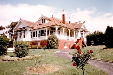
 Kew Historical Society Inc
Photograph - 'Neama', Studley Park Road, 1978
Edward Augustus Atkyns was born in Wiltshire, England in 1840. His family emigrated to Australia in 1852. As a young man he was a keen cricketer and played at the first cricket ground in the district, located between Barkers Road and Hawthorn Grove, on the site of the future Barker railway station. Atkyns was admitted to the Victorian Bar in 1861, initially working in his father’s practice. He sat as a local magistrate in both Kew and Hawthorn and acted as solicitor for several shire councils. Elected to the Hawthorn Borough Council in 1863 at the age of 23, he served in that municipality as mayor in 1866-67. By 1877, he had moved to Kew where he lived at Neama in Studley Park Road, a property later incorporated into the St Paul’s School for the Blind.Rare colour photograph of what was once a significant house in Kew.Original colour positive photograph (Kodak print) of the main house of 'Neama', colloquially known as the 'farmhouse'. Photographed by Stewart West in April 1978 (it was later demolished by the Villa Maria Society).Annotated reverse: "Front view of Neama / Farmhouse on St Paul's School for the Blind Children / Fernhurst Estate"st paul's school for the blind, neama, studley park road -- kew (vic.), historic houses -- kew (vic.), villa maria society