Showing 2158 items matching " reef"
-
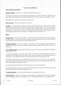
 Bendigo Historical Society Inc.
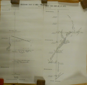
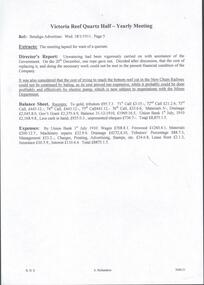
Plan - MARKS COLLECTION: UNDERGROUND SURVEY OF MINES SANDHURST NEW CHUM LINE OF REEF
Plan, divided into two sheets, on top of sheet Underground survey of mines Sandhurst, New Chum Line of Reef. Surveyed by Caleb Thomas under the direction of Charles W. Langtree, Acting Secretary for Mines and Water Supply and Acting Chief Mining Surveyor for the Colony of Victoria. Drawn by Arthur Everett, Mining Department, Melbourne, 1884.bendigo, mining, new chum line of reef -
 Bendigo Historical Society Inc.
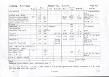
Document - THE LAZARUS MINE - PRODUCTION NOTES OF THE THE LAZARUS MINES
Handwritten notes including depth of shaft, years, call, dividends, tons of ore, amount of gold, authority and remarks. On the second page:- Lazarus, Lazarus New Chum and Lazarus No 1. 1886 At 1675 ft Gold discovered unexpectedly when timbering. Manager cut in on reef, found good stone. Notes prepared by Albert Richardson.document, gold, the lazarus mine, the lazarus mine, production notes of the the lazarus mines, early workings, begelhole & co (north), geo gibbs & lazarus claim, watson & co, ballerstadt & co, lazarus freehold, lazarus freehold, lazarus new chum (april), lazarus co, lazarus no 1, lazarus no 2, lazarus new chum m co, abe lincoln trib co, central new chum, abe lincoln sands, bendigo goldfield history and production page 107, annals 1886 page 208 -
 Bendigo Historical Society Inc.
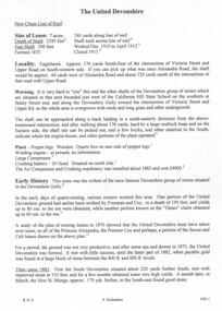
Document - THE UNITED DEVONSHIRE MINE - NOTES ON THE UNITED DEVONSHIRE MINE
One handwritten and three typed copies of notes on The United Devonshire Mine on the New Chum Line of Reef. Notes include size of lease, depth of shaft, East Shaft, locality, a warning on the area where the shaft is, plant, early history. Leading and Prominent, Best Gold, Total Yields and Dividends. Notes prepared by Albert Richardson.document, gold, the united devonshire mine, the united devonshire mine, notes on the united devonshire mine, california hill state school, freeman & coy, the 'danes', princess alexandra, the premier coy, saxon & celt, south devonshire, new st mungo, duke of edinburgh, phoenix mine, duchess tribute, duchess of edinburgh, albert battery, mines dept special edition australian mining standard 1/6/1899, mines dept booklet bendigo goldfields 1936, mines dept annual and quarterly reports, annals of bendigo mining sections 1881 - 1916, a richardson, mines dept bulletin no 47 structure of bendigo goldfield h herman 1923, the bendigo goldfield registry j n macartney 1/3/1871 -
 Bendigo Historical Society Inc.
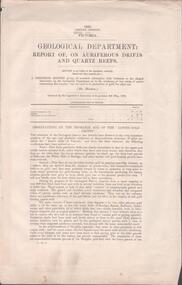
Document - MINING REPORTS - REPORT OF, ON AURIFEROUS DRIFTS AND QUARTZ REEFS
Printed document: Geological Department: Report of, on auriferous Drifts and Quartz Reefs, dated 8th May,1866. Paper describes the gravels and rocks of a Geological Survey. Survey is compared with the lower drifts of Bendigo, Epsom, Ballaarat, Castlemaine and other gold-fields. Four colour sketch-sections included. Document is part of the Albert Richardson Collection. gold, mining reports, mining reports, report of, on auriferous drifts and quartz reefs, mr bindon, alfred r c selwyn, john ferres -
 Bendigo Historical Society Inc.
Document - MINING REPORTS - BENDIGO GOLDFIELD PRODUCTION
Handwritten notes by Albert Richardson, (typed copy) detailing tons of ore and ounces of gold it produced for mines on the Hustlers, Paddy's Gully, Garden Gully, Deborah, Sheepshead, New Chum, Nell Gwynne, Napoleon, Lancashire, Thistle and Christmas Lines of Reef. Also the Napoleon Syncline and Mary McDonald Spurs. Also mentioned is the average per ton.document, gold, mining reports, mining reports, bendigo goldfield production, m d, q r & a r, bendigo advertiser, b m l, burrell's records -
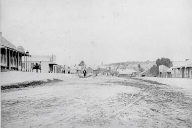
 Stawell Historical Society Inc
Photograph, Streetscape of South side of Upper Main Street Reefs Stawell looking East from around Patrick Street corner with Big Hill Mining in background c 1867
Upper Main Street east of Patrick street, looking East c 1867 with Big Hill Mining in Background. J McGee's Shamrock Hotel. Jennings Western Turf Hotel. R Lorimer & Co. Photo c 1867 McGees Shamrock Hotel centre. R. Williams Dining Rooms,. Jennings's Western Turf Hotel situated in upper Main Street (Opposite Monaghan's Estate Office) Mr. George Jennings was proprietor until the late 1860's when he went to live at "Mayo Park" Lubek. The Hotel had Various owners until it was delicensed in 1909 and became a boarding house. It was demolished in 1921. R. Lorimer & Co general Store near corner of Patrick Street.Streetscape of South Side of Main Street East of Patrick Street. Two wagons in street. Showing J. McGees Shamrock Hotel, R Williams Dining Rooms, Jennings's Western Turf Hotel and R. Lorimer & Co. Mine Engine Chimney is on left of photo. Big Hill in Background with Waterloo Reef Company Whim at centre.stawell streetscape -
 Bendigo Historical Society Inc.
Document - NEW MOON MINE - NOTES ON THE NEW MOON MINE
Handwritten notes on the New Moon Mine on the Garden Gully Line of Reef. Notes include depth of Shaft, locality, Formation & Registration, Last year of production 1931, Size of lease, Early History, Plant, Poppet Legs, Telephone & Electric Signalling, Gold Obtained, Prominence, Total Gold Production and Dividends. ( duplicate of record 3559.1)document, gold, new moon mine, notes on the new moon mine, garden gully line of reef, prospector's vote, h harkness & coy, thompson & co of castlemaine, bendigo amalgamated goldfields coy, mines dept special edition australian mining standard 1/6/1899, mines dept annual and quarterly reports, a richardson -
 Bendigo Historical Society Inc.
Map - COMET MINE - TRANSVERSE SECTION COMET MINE
Transverse section of the Comet Mine on the Hustler's Line of Reef Bulletin No 33, Plate No XXV signed by H. A. Whitdon, Underground Survey Office Bendigo September,1913. Map shows depth of the different levels, the type of stone and shaft about 2020 deep. A number of smaller drawings on the side. Reference explaining the different types of stone, etc. Geological Survey of Victoriamining, hustler's line of reefs, transverse section of comet mine bulletin no 33 plate no xxv, lightning hill line of reef -
 Queenscliffe Maritime Museum
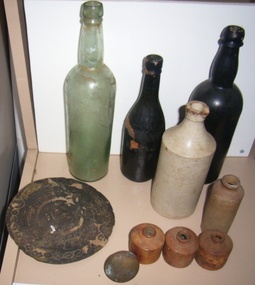
Domestic object - 10 items recovered from the Cambridgeshire wreck site
CAMBRIDGESHIRE (J. Marshall) was on voyage from Gravesend UK to Sydney, New South Wales with a cargo of general goods and a crew of 40, when she was lost off Cambridgeshire Reef. Read more at wrecksite: https://wrecksite.eu/wreck.aspx?543123 glass bottles, 3 ceramic ink bottles, 2 ceramic bottles, 1 brass door knob, 1 engraved metal discunderwater relics, salvage, glass bottles, ceramic bottles, ceramic ink wells -
 Queenscliffe Maritime Museum
Functional object - Bottle, earthenware
CAMBRIDGESHIRE (J. Marshall) was on voyage from Gravesend UK to Sydney, New South Wales with a cargo of general and a crew of 40, when she was lost off Cambridgeshire Reef Tasmania. Read more at wrecksite: https://www.wrecksite.eu/wreck.aspx?54312Earthenware bottle from the wreck of the Cambridgeshireshipwrecks, cabridgeshire, salvage, bottle -
![View of the Township of Mt. Blackwood / [by] Nicholas Caire, circa 1876](/media/collectors/550653872162f11fb04854aa/items/57830cfbd0cdd1176c424e00/item-media/57830d7ad0cdd1176c428423/item-fit-380x285.jpg) Kew Historical Society Inc
Kew Historical Society IncPhotograph, Anglo-Australasian Photographic Company, View of the Township of Mt. Blackwood, c. 1876
Nicholas Caire was born on Guernsey in the Channel Islands in 1837. He arrived in Adelaide with his parents in about 1860. In 1867, following photographic journeys in Gippsland, he opened a studio in Adelaide. From 1870 to 1876 he lived and worked in Talbot in Central Victoria. In 1876 he purchased T. F. Chuck's studios in the Royal Arcade Melbourne. In 1885, following the introduction of dry plate photography, he began a series of landscape series, which were commercially successful. As a photographer, he travelled extensively through Victoria, photographing places few of his contemporaries had previously seen. He died in 1918. Reference: Jack Cato, 'Caire, Nicholas John (1837–1918)', Australian Dictionary of Biography.An original, rare photograph from the series 'Views of Victoria: General Series' by the photographer, Nicholas Caire (1837-1918). The series of 60 photographs that comprise the series was issued c. 1876 and reinforced a neo-Romantic view of the Australian landscape to which a growing nationalist movement would respond. Nicholas Caire was active as a photographer in Australia from 1858 until his death in 1918. His vision of the Australian bush and pioneer life had a counterpart in the works of Henry Lawson and other nationalist poets, authors and painters.‘View of the Township of Mt. Blackwood’ : Views of Victoria (General Series) No.42 : Albumen silver photograph | Photo on card with Title and Description on reverse | Mounted 24 x 30 cm; Photo 12 x 17 cm.On Reverse: ‘The locality which this illustration represents was formerly known as the Blackwood Forest, and has been the scene of considerable mining activity. The shallow alluvial diggings of the early days have given place to the deep sinking in search of reefs. This scene is characteristic of the wild appearance which many of the inland townships of Victoria represent.’nicholas caire (1837-1918), blackwood (vic), mount blackwood, landscape photography - victoria -
 Phillip Island and District Historical Society Inc.
Photograph, Bryant West
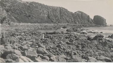
One of a collection of over 400 photographs in an album commenced in 1960 and presented to the Phillip Island & Westernport Historical Society by the Shire of Phillip IslandPhotograph of Rocks and Beach south side of Cape Woolamai.local history, photography, photographs, coastline, rocky beach, reef, cape woolamai, phillip island, reefs, john jenner, bryant west -
 Bendigo Historical Society Inc.
Document - DRAINAGE PROBLEMS - VICTORIA REEF QUARTZ HALF=YEARLY MEETING
Handwritten extract of the Victoria Reef Quartz Half-Yearly Meeting from the Bendigo Advertiser Wed 18/1/1911 Page 5. The meeting lapsed for want of a quorum. Director's Report states unwatering had been vigorously carried on with assistance of the Government. On 20 December, one rope gave out. After discussion, it was decided it was too costly to replace with the present financial condition of the Company. It was also considered that the cost of trying to reach the bottom reef cut in the New Chum Railway could not be continued by baling, as its cost proved too expensive, while it probably could be done profitably and effectively by electric pump, which is now subject to negotiations with the Mines Department.'' Also included is a Balance Sheet. From the Albert Richardson Mining History Collection.document, gold, drainage problems, drainage problems, victoria reef quartz half-yearly meeting, bendigo advertiser, 18/1/1911 page 5, new chum railway, mines department, balance sheet victoria reef quartz, ar -
 Bendigo Historical Society Inc.
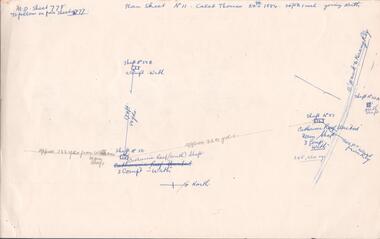
Document - MINING REPORTS - CALEB THOMAS PLANS
Copy of Caleb Thomas plans, (a) Sheet No 778, dated 24th 1884. Mines mentioned are: Catherine Reef (South) Shaft, Catherine Reef United Main Shaft, Shaft No 50B, Shaft No 51A North Shaft and the Williams Main Shaft. Mentioned are distances from each mine in yards and from the Eaglehawk to Kerang Railway in feet. Also mentioned are ounces of gold. (b) Sheet No III dated 10/10/1884. Mines mentioned are: York & Durham, Arcadia Catherine, Williams (Old) Shaft, Trio-Hauling Co, South Catherine (later Williams United Main Shaft and others by shaft numbers. Mentioned are distances in yards or feet from each mine, number of compartments and ounces of gold. Document is part of the Albert Richardson Collection.document, gold, mining reports, mining reports, caleb thomas plans, york & durham, acadia catherine, williams (old) shaft, trio-hauling co, south catherine (later williams united main shaft -
 Bendigo Historical Society Inc.
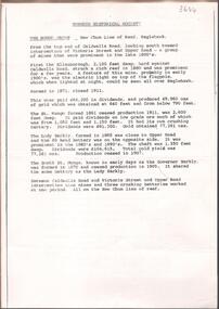
Document - NEW CHUM LINE OF REEF MUNGO GROUP EAGLEHAWK
Two page document detailing the Mungo Group of Mines along the New Chum line of reef, Eaglehawk. The mines described are: Ellenborough, 2100 feet deep St Mungo, 2,600 feet deep The Lady Barkly, 1,350 feet deep, close to Upper Road with a 40 head battery on the other side. South St Mungo, known as the Governor Barkly in the earlier days. Small map on second page shows the location of the Sadowa shaft, St. Mungo shaft and the Lady Barkly shaft. Victoria Street and Upper Road marked on the map. 'Between Caldwells Road and Victoria Street and Upper Road intersection, nine mines and three crushing batteries worked at one period. All on the New Chum line of reef.' Not signed but most probably written by Albert Richardson.bendigo, mining, mungo group of mines, eaglehawk -
 Bendigo Historical Society Inc.
Document - BENDIGO AND VICTORIA HILL REPORT ON GEOLOGY
Report, 8 pages, on the geology of Bendigo district and Victoria Hill, produced by the Geological Survey Dept., Victorian Government. G.J. Medwell, Geologist. 19.10.1967. On front 'Geological Survey of Victoria. Mines Department Victoria. Report on Geology of Bendigo and of Victoria Hill Area' Letter attached inside front cover to J.C.Balfour, Minister of Mines to G.A. Lambert, Liberal Party, Sunshine, Victoria, sent with book for his information. Report contains: Cobaw batholith and North Harcourt Bendigo goldfield generally Trought, reefs, saddles and spurs Victoria Hill mines; Victoria Consols, Great Central Victoria, Victoria Quartz, Lansells 180, North Old Chum. Maps attached show part of New Chum line of reef and a handdrawn map of Rae's Cutting.bendigo, mining, victoria hill, bendigo goldfield -
 Bendigo Historical Society Inc.
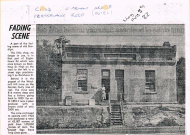
Newspaper - LONG GULLY HISTORY GROUP COLLECTION: E BRYANT - GROCER
BHS CollectionCopy of a newspaper article titled Fading Scene. Photo shows a building with a stairway leading down to the road in front of it and a lady standing in the doorway. One window has Cash Store printed on it and there are two placards leaning on the building to the left of the lady. Each side of the building are shrubs and picket fence. In the background to the left is the poppet of the Windmill Hill Mine on the Garden Gully line of reef. It is in that part of Eaglehawk Rd which was once known as Backhaus St. High on the wall to the left is a street sign proclaiming it as Backhaus St. Written above the photo is C-sh, E Bryant, Gro-er (there are holes through the words), Perseverance Reef (Hotel). Wed Feb 3rd 82. Article is mounted on yellow card which is mounted on purple card and laminated.bendigo, history, long gully history group, the long gully history group - e bryant - grocer, windmill hill mine, garden gully line of reef, e bryant, perservance reef (hotel) -
 Bendigo Historical Society Inc.
Map - HUSTLER'S ROYAL RESERVE NO 2 MINE - PLAN OF THE HUSTLER'S ROYAL RESERVE NO 2 MINE
Plan of the Hustler's Royal Reserve No 2 Mine Bulletin No 33, Plate No V. Plan shows the Hustler's Royal Reserve No 2 (Main Shaft), Hustler's Royal Reserve No 2 (Park Shaft.), the Royal Hustler's, the Imperial Hustler's and the Extended Hustler's Freehold on the Hustler's Line of Reefs. Also mentioned is the Lightning Hill Line of Reefs. Map shows some of the levels, approximate boundary of lease and the boundary of Lease No 8892 and 8897. There are also street names and the locations of jail, lagoons, Post Office, Rosalind Park and the State School, High School and Continuation School. Geological Survey of Victoria emblem. H. Herman Director, W. Dickson, Secretary of Mines and The Hon. J. Drysdale Brown MLC, Minister of Mines. Signed by zh Whitdan, Underground Survey Office, Bendigo, September 1913.mining, parish map, hustler's royal reserve no 2 mine, royal hustler's, imperial hustler's, extended hustler's freehold, geological survey of victoria, h herman, w dickson, the hon j drysdale brown, h whitdan, hustler's line of reefs, lightning hill line of reefs -
 Stawell Historical Society Inc
Photograph, Pedestrian Mall & Lower Main Street Stawell from the Town Hall Clock Tower
Stawell from top of Town Hall looking at upper Main Street. Gold Reef Mall on left. Post Office Arcade in centre of photo. Stawell Technical School prominent in photo. Town Hall Hotel at right of photo. 1980-1984stawell business streetscape -
 Queenscliffe Maritime Museum
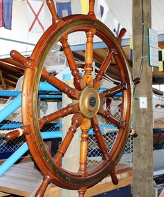
Functional object - Ship's Wheel from S S George Kermode, 1914
The Melbourne Harbour Trust Commission purchased the steam dredge SIR WILLIAM MATHEWS on 10 October 1941 from the Western Australian Government. Although the dredge was described as a suction dredge it was in fact a bucket dredge. After an overhaul, the vessel was renamed the GEORGE KERMODE and commenced operation in Victorian waters on 22 June 1942. The vessel was hired out to the Port of Burnie in 1945-46 but continued in the ownership of the Trust until 1 April 1976 when it was scuttled by the Department of Conservation, Forests and Lands as part of their artificial reef program. This program resulted in a number of reefs being established in Port Phillip Bay, including one off Carrum containing the wooden steamer URALBA.Timber and brass ship's wheel from center ladder hopper dredge George Kermode (formerly Sir William Mathews). Built Paisley Scotland 1914.noneships wheel, scuttled vessels, artificial reefs, george kermode -
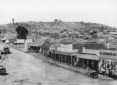
 Stawell Historical Society Inc
Photograph, Upper Main Street Reefs looking East towards Big Hill from the front of Joyce's Hibernian Hotel 1866
Upper Main Street Reefs looking East towards Big Hill taken from front of Joyce's Hibernian Hotel . Part of a collection of Photographs by Mr. O.G. Armstrong as commissioned by the Shire of Stawell for the Inter-colonial and Paris Exhibition in Melbourne in 1866. This scene was taken in 1866 in Main Street from in front of Joyce’s Iberian Hotel on the left, the site of the present townhall. It is looking uphill and eastward with Big Hill in the far background. The Hibernian Hotel was built on Commercial Street Pleasant Creek Goldfields in 1858 and was moved to Main Street Reefs, the present site of the Town Hall by Mr. & Mrs. Joyce. It was later destroyed by fire and the Town Hall built on its location. Street scene with buildings in distance and Big Hill in far distance.stawell streetscape -
 Bendigo Historical Society Inc.
Book - MCCOLL, RANKIN AND STANISTREET COLLECTION: SHARE TRANSFER JOURNAL ALL COMPANIES, 1957/60
Book; Cloth bound loose leaf folder contains tabbed dividers for many mining companies, but, most are empty - Nell Gwynne Reef No Liability sheet No. 4. North Deborah Mining Company N.L. sheets 120-158. North Deborah Mining Co. N.L. (contributing) 64/69. Typewritten sheets. Share Transfer Journal - all companies.MCCOLL RANKIN & STANISTREETorganisation, industry, accounting., mccoll rankin & stanistreet -
 Bendigo Historical Society Inc.
Map - STRUGNELL COLLECTION: HUSTLER'S LINE OF REEF, BENDIGO, September 1913
Map, Hustler's Line of Reef, Hustler's Royal Reserve No. 2 Co, Bendigo,Transverse Section, Plate No.V11 (7). Bulletin No 33 Signed H.A.Whitelaw Underground survey Office Bendigo September 1913 Drawing shows mine shaft to over 1640 feet deep and appears to show samples of connecting horizontal shafts with their respective mineral contentsUnderground Survey Office, Bendigo.map, bendigo, hustler's royal reserve no. 2 mine* -
 Bendigo Historical Society Inc.
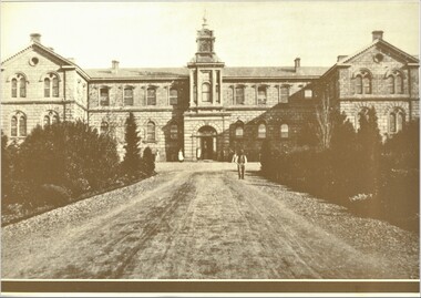
Photograph - PHOTOGRAPHS OF BENDIGO (COPIES)
Seven copies of sepia photographs of Bendigo. a. Bendigo Hospital b. Hustler's Reef Mine Bendigo c. View Street Bendigo d. Shamrock Hotel (second Building). e. City Family Hotel f. Old Chum Claim g. Old Chum Hill Enlarged copies of photos. Each photo has a 1.2 cm brown border.bendigo, history, buildings/streetscapes -
 Bendigo Historical Society Inc.
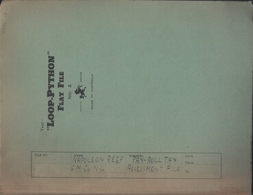
Document - MCCOLL, RANKIN AND STANISTREET COLLECTION: NAPOLEON REEF GOLD MINING CO. N.L, 1941-1950
Documents: Napoleon Reef Gold Mining Co Pay Roll Tax Assessment File, Loop Python Flat File containing Payroll Tax Exemption Certificates and Return of Wages Paid (Annual) from 1941 - 1950, Also a Payroll Tax Refund notification dated 3 March 1944, Markings: File Name written in ink on front cover.organization, business, industrial - mining, mccoll rankin & stanistreet, mining, gold mining, napoleon reef -
 Bendigo Historical Society Inc.
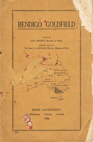
Book - JOAN O'SHEA COLLECTION: BENDIGO GOLDFIELD BOOK, 1936
Joan O'Shea collection. Buff coloured book issued by Mines Department Melbourne. Victoria Australia 1936. Information contained within refers to History, Recent developments and future Prospects, Geology, Lines of Reef for the Bendigo area, information regarding tonnage of gold and values of same at that time. The index at the rear of the book lists all of the mines in the Bendigo area.Geo. Brown, Secretary for Mines, Mines Departmentmining, business, mines department -
Tarnagulla History Archive
Newspaper article - A Promise Of A Golden Rebirth Rekindles Fire And Hope In The Aging Heartbeat Of The Old Tarnagulla, A Promise Of A Golden Rebirth Rekindles Fire And Hope In The Aging Heartbeat Of The Old Tarnagulla, June 4,1988
Don Clark Collection. An article (across two clippings) from the Bendigo Advertiser newspaper of June 4,1988 titled 'A Promise Of A Golden Rebirth Rekindles Fire And Hope In The Aging Heartbeat Of The Old Tarnagulla'. Discusses Western Mining returning to mine Poverty Reef and hopes it will revitalise the town of Tarnagulla. Images of Les Williams, John Lavery, Chris Williams, Don Shipston and Bill Goltz. tarnagulla, mining, western mining, revitalization, people, golden age hotel, lochcarron -
 Bendigo Historical Society Inc.
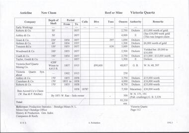
Document - VICTORIA QUARTZ - NOTES ON VICTORIA QUARTZ
Handwritten page of notes listing Company, Depth of Shaft, Years and Ounces of Gold, Names of Companies listed: Roberts & Co, Ashley & Co, Grant & Co, Holmes & Co,Touzeau & Co, Woodward & Co, Coath & CO, Taylor Gould & Co, Victoria Reef Quartz Mining Co, Victoria Quartz Syn, Cranshaw & Co and Bon Accord Co.document, gold, victoria quartz, victoria quartz, notes on victoria quartz, roberts & co, ashley & co, grant & co, holmes & co, touzeau & co, woodward & co, coath & co, taylor gould & co, victoria reef quartz mining co, victoria quartz syn, cranshaw & co and bon accord co, dickers, macartney, w rae, p ritchie, production statistics - bendigo mines n l, mines dept bendigo, history & production gen index of companies & reefs -
 Bendigo Historical Society Inc.
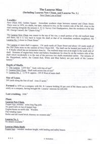
Document - THE LAZARUS MINE - NOTES ON THE THE LAZARUS MINE
One siix page handwritten and three typed copies of notes on the The Lazarus Mine including the Lazarus New Chum and the Lazarus No 1 on the New Chum Line of Reef. Notes include locality, depth of shafts, size of lease, plant, early history, the Lazarus Company, Prominence, Best Gold and Total Gold Yields. Notes prepared by Albert Richardson.document, gold, the lazarus mine, the lazarus mine, notes on the the lazarus mine, lazarus new chum, lazarus no 1, australian headquarters survey unit, george lansell, new chum hill, b c v 8 studios, sheepshead, central red white & blue, mr lazarus, lansell's 222, old chum mine, lazarus company, mr george gibbs, lansell's fortuna, ballerstedt, mr barnet lazarus, the black lead, the white lead, mount alvernia hospital, mines dept special edition 'australian mining standard' 1/6/1899, mines dept booklet 'bendigo goldfield' 1936, mines dept annual and quarterly reports, annals of bendigo mining sections 1868 - 1910, a richardson, the bendigo goldfield registry j n macartney 1/3/1871 -
 Bendigo Historical Society Inc.
Document - NEW CHUM RAILWAY MINE - NOTES ON THE NEW CHUM RAILWAY MINE
Typed copies of handwritten notes on the New Chum Railway Mine on the New Chum Line of Reef. Notes include depth of shaft (4,318 feet), Size of lease, locality, plant - includes poppet legs,winding engine, two engine houses, crushing battery, early history, where the best gold was found, prominence, total gold production and dividends.document, gold, new chum railway mine, new chum railway mine, notes on the new chum railway mine, w d c denovan, mr piper, rourke & henderson's claim, mines dept special edition australian mining standard 1/6/1899, mines dept booklet 'bendigo goldfield' g brown 1936, 'annals of bendigo' mining sections 1890 to 1910, a richardson