Showing 113059 items
matching road
-
 Mt Dandenong & District Historical Society Inc.
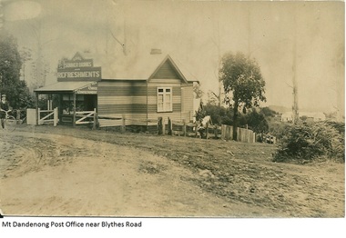
Photograph, Mt Dandenong Post Office Near Blythes Road
The Mt Dandenong Post Office & Store was originally built by Will Dower. The house and shop was built in 1912 and staffed by Ruby and Ada Dower. It became the Post Office in 1917 when Lil Badenhop sold her business following the death of her daughter Myrtle. The Post Office and Store closed in 1926 when the new premises opened on the Main Road.Black and white photograph of Dower's house and shop built on the corner of Old Coach Road and Farndons Road in Mt Dandenong. A boy with a bicycle can be seen at the LHS edge of the photograph and the Mt Dandenong State School building directly behind the shop.dower, will dower, mt dandenong, mt dandenong school, mt dandenong store, mt dandenong post office, ruby dower, ada dower -
 Glen Eira Historical Society
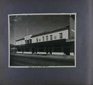
Album - Album page, London Tavern, Hawthorn Road, Circa 1972
This photograph is part of the Caulfield Historical Album 1972. This album was created in approximately 1972 as part of a project by the Caulfield Historical Society to assist in identifying buildings worthy of preservation. The album is related to a Survey the Caulfield Historical Society developed in collaboration with the National Trust of Australia (Victoria) and Caulfield City Council to identify historic buildings within the City of Caulfield that warranted the protection of a National Trust Classification. Principal photographer thought to be Trevor Hart, member of Caulfield Historical Society. Most photographs were taken between 1966-1972 with a small number of photographs being older and from unknown sources. All photographs are black and white except where stated, with 386 photographs over 198 pages. Glen Eira Heritage Management Plan 1996 by Andrew Ward The 1857 rate book indicates that the major portion of the District was under pasture, although a considerable portion was cultivated. There were 159 houses, huts and tents whose occupants were mainly occupied on the land. If "Camden Town" was the principal commercial focus for the District in 1857, it was to remain so in later years, incorporated today in the Glenhuntly Road centre which extends more or less continuously from Elsternwick to Bambra Road. The Caulfield State School of 1877, the horse tramway of 1889 and subsequently the electric trams were all events confirming the importance of Glenhuntly Road and the fledgling community of "Camden Town" wherein the City's commercial centre has its origins. It is recalled, today, by their presence, and also by the "London Tavern" in Hawthorn Road, established by John Guess in 1873. Dr Geulah Solomon's 4 volume book "Caulfield's Heritage" Vol 1 p 93: "A modern hotel presently on the site continues the name of the London Tavern." That was true until recent years as the hotel is named The Camden Hotel now (2021).Page 81 of Photograph Album with one landscape photograph of the front of the London Tavern with handwriting on the edge of the photograph.Hand written: LONDON TAVERN HOTEL 1937 [on bottom edge of photo] / 81 [bottom left] trevor hart, caulfield, hawthorn road, london tavern, camden town, john guess, hotels, pubs, victorian, 1870's, 1930's, sycamore street, the camden hotel -
 Eltham District Historical Society Inc
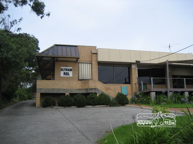
Photograph, Liz Pidgeon, Eltham RSL, Main Road, Eltham, 18 February 2011
This site once formed a row of shops forming part of the early ribbon of development along Main Road. The Returned and Services League of Australia (RSL) is a support organisation for people who have served or are serving in the Australian Defence Force. Eltham RSL Sub Branch amalgamated with the Montmorency RSL in 2012 with this building subsequently sold and demolished. Born Digitaleltham, main road, eltham rsl, eltham rsl sub-branch -
 Eltham District Historical Society Inc
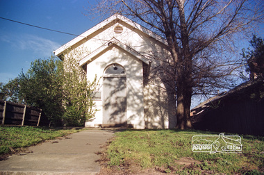
Photograph, Doug Orford, Eltham Courthouse, 730 Main Road, Eltham, 1985, 1985
This building is a fine example of a very early small brick country court house which retains its furnishings and has important associations with the early history of the Eltham township. It was used for Eltham Road Board meetings in the 1860s and later to provide additional school accommodation. It is the oldest public building remaining in Eltham and forms an important group in historic and streetscape terms with the adjoining former police residence. The survival of the furnishings (of unknown origins) is of particular significance given the building's age. This building, and the former police residence beside it, were constructed as a result of a petition by five Eltham residents in 1857. The nearest police were at Heidelberg eight miles away or at the Caledonia Diggings 21 miles away. After the construction of the Court of Petty Sessions at Eltham in 1859-60 (which was designed by the Public Works Department and built by a Mr Duncan for a cost of 536 pounds), it was used for a variety of purposes. Eltham Road Board meetings were held there until 1868 when the board was transferred to Kangaroo Ground and as the Road Board Secretary's office, until this was transferred to Wingrove Cottage in 1867. It was used as an overflow for the Dalton Street School in 1875. According to National Trust records, the Eltham Court House is a relatively rare building type. There are only six other known examples of similar small brick country court houses in the state which have small projecting entry porches and a gabled form. Roll of 35mm colour negative film, 7 stripsFuji 100Neltham, eltham courthouse, main road -
 Surrey Hills Historical Society Collection
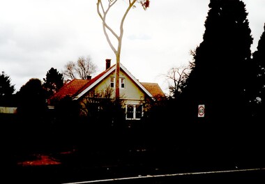
Photograph, 627 Whitehorse Road, Surrey Hills
This has been a home/surgery for a number of general practitioners. Dr Hedley Francis Summons is listed on the 1931 and 1936 electoral roll as resident / practising here. He was born in Kew in 1899 (died in 1967) and married Elsie Florence Finlayson in 1925. They had a son and daughter. In 1937 the family returned to Melbourne from Edinburgh. He became Lt Colonel of the 2nd 9th Field Ambulance, 2nd AIF in WW2. He was taken POW on the fall of Singapore and there is a portrait of him by Murray Griffin done in Changi. Dr Lorimer Grant Morton (1904-1989) graduated in 1931 and was registered at 627 Whitehorse Road in that year until c1937. Dr Alan Herbert McNaughton graduated in 1932 and was the general practitioner during the WW2. He is listed at the address in the 1942 and 1943 electoral roll. He married Nancy Winifred Bottomley in 1940. Dr Jack Ramsay Collie (1914-1990) was a general practitioner at 627 Whitehorse Road from c1954-1980. He served in RAN in WW2; married Mary Sewell Graham in 1945 and had a son and a daughter. 627 Whitehorse Road probably ceased as a medical practice after his retirement. Sale history: Sold in November 2007 by Marshall White Real Estate for $1.455M Sold in September 2011 by Jellis Craig real Estate for $1.75MThe house is significant as an example of past practice of general practitioners having their surgeries as part of their home. This example is from a later date than the Surrey Hills Medical Centre (SHMC) at 174 Union Road, which was purpose-built for Dr James Landells Blakie in c1911. In this case the building has reverted to domestic use, whereas in the case of SHMC its use became solely medical.A coloured photograph of a house with an established garden and a wire fence along the front. A tall gum tree stands in front of the house.surrey hills, whitehorse road, doctors, dr hedley francis summons, dr jack ramsay collie, (miss) mary sewell graham, (mrs) mary sewell collie, dr donald malcolm collie, (miss) elsie florence finlayson, (mrs) elsie florence summons, dr alan herbert mcnaughton, (mrs) nancy winifred mcnaughton, dr lorimer grant morton -
 Tatura Irrigation & Wartime Camps Museum
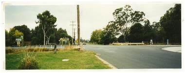
Photograph, Whim Inn Corner, Hogan Street and Dhurringile Road, Tatura
Shows picture of Whim Inn corner, Hogan Street and Dhurringile Road, Tatura. Colour photograph showing the intersection of Hogan Street, and Dhurringile Road, Tatura. Known as Whim Inn corner. Before round about put in. Photograph stuck onto piece of white cardboard. hogan street tatura, dhurringile road tatura, whim inn tatura -
 Marysville & District Historical Society
Photograph (Item) - Black and white photograph, c1940s
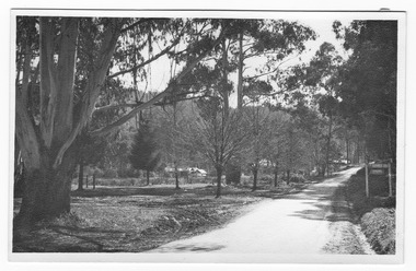
A black and white photograph of the Marysville-Buxton Road in Marysville in Victoria.A black and white photograph of the Marysville-Buxton Road in Marysville in Victoria. This road leads from Murchison Street, which is the main street, in Marysville in Victoria.Buxton Roadmarysville-buxton road, marysville, victoria, murchison street -
 Ringwood and District Historical Society
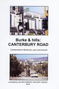
Book, Burke & Hills: Canterbury Road Camberwell to Montrose, by Heathmont History Group - 2014
Soft cover book of 40 pages with spiral wire spine. Compilation of images and descriptive timeline of the geology, geography and European settlement history of Canterbury Road.Soon after beginning at Burke Road Camberwell, Canterbury Road moves into the gentle hills of Canterbury, then on to Surrey Hills, Box Hill and Forest Hill. Further along past these three "hills" come three "monts" - Vermont, Heathmont and at its other end, Montrose, by then in the foothills of the Dandenongs. Grand homes and churches at one end, major and minor shopping centres along the 25km, factories now where farms were, big box stores, fast food outlets, train stations, resrvoir, traffic, residential stretches, modern apartment blocks, parklands, child-minding centres, sporting ovals, a sewage farm, hotels, quarries, commercial developments, plant nurseries, a golf course, bridges, memorials, Asian food shops, telecommunication towers, bushland, creeks, crossroads, traffic lights, mansions, orchards, swamps ... Delaneys Road, renamed Canterbury Road after a 19th century Victorian Governor, is a fascinating study in land use and history as suburban Melbourne has continually diversified and pushed outwards. Compiled by Heathmont History Group, Rita James, Les Prato, Betty Colbert, Jeff Leipold, Gerry Robinson (convenor). -
 Glen Eira Historical Society
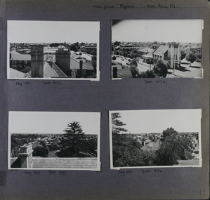
Album - Album page, Myoora, 405 Alma Road, Circa 1972
This photograph is part of the Caulfield Historical Album 1972. This album was created in approximately 1972 as part of a project by the Caulfield Historical Society to assist in identifying buildings worthy of preservation. The album is related to a Survey the Caulfield Historical Society developed in collaboration with the National Trust of Australia (Victoria) and Caulfield City Council to identify historic buildings within the City of Caulfield that warranted the protection of a National Trust Classification. Principal photographer thought to be Trevor Hart, member of Caulfield Historical Society. Most photographs were taken between 1966-1972 with a small number of photographs being older and from unknown sources. All photographs are black and white except where stated, with 386 photographs over 198 pages.Victorian Heritage Register (VHR) Number H0490 From the Victorian Heritage Register Database - Citation for Myoora https://vhd.heritagecouncil.vic.gov.au/places/275 (as at 6/10/2020) Myoora, 405 Alma Road, North Caulfield, was designed by Reed, Henderson & Smart and can be attributed to Anketell Henderson. It was built in 1886 and 1887 for Thomas Christian, who had founded the fabled gold mine, the Day Dawn at Charters Towers. He never occupied the house although his widow lived there for some time. The house was subdivided into three and later six flats. Myoora was one of many large mansions on broad acres with gardens in Caulfield. Perhaps the grandest was Labassa. The mansions date from the 1850s through to the late 1890s. The siting of Myoora on a ridge influenced its planning and composition. A central hall and corridor along the ridge is entered from the centre of the more formal north facade. The entrance is marked by an elaborately detailed tower. A stair turret provides a second accent. The western end of the building is completed by a massively detailed chimney as the service wing. The south facade enjoyed an outlook to port phillip from a two-storey cast iron verandah. Bay windows, chimneys, the tower and the turret and minor details are brought together in a sophisticated asymmetrical composition. This is reflected in the planning. The asymmetry of Myoora pivoting on the tower is the most notable feature of the building. The walls are built of cement rendered brick. The cement render has not been painted. The roof is slate. The balconies and verandah are cast iron. The footings and cellar are bluestone. The architectural firm Reed, Henderson & Smart was very prominent in Victoria in the nineteenth century. Anketell Henderson was an eminent and well respected member of the profession. He worked successfully in London and interstate as well as in Victoria. They were better known for commercial and public buildings. Myoora is an important private commission. The style of Myoora is a combination of details from the Continental and English Renaissance through the boom style and the Queen Anne style. There is also an early influence from the American Romanesque style especially in the stair turret. The latter style was important at the turn of the century and Myoora is a significant precursor. Other buildings of a similar scale survive in Caulfield and elsewhere. Labassa, the most fabulous, is quite different stylistically as are most of the other comparable mansions. Stonnington is perhaps closer but relies on different details from the Queen Anne style and lacks any American influence. For its historical associations through its owners and architects, for its style and composition and for its intactness, Myoora is significant at a State level. The craftmanship of Myoora is what could be expected of a building of the time and type. It is relatively intact and in fair condition. The main staircase has been removed, minor alterations to decorative features have occurred and additions have been made to the exterior.Page 18 of Photograph Album including four black and white photographs. All are arranged in landscape orientation with two on the top half of the page and the other two below.Handwritten: views from "Myoora" 405 Alma Road / [top right hand] / Neg 188 Dec 1972 [under top left photo] / Dec 1972 [under top right photo] / Neg 184 Dec 1972 [under bottom left photo] / Neg 168 Dec 1972 [under bottom right photo] / 18 [bottom right]caulfield north, trevor hart, alma road, mansion, myoora, tower, thomas christian, 1880's, queen anne, turret, cement rendered brick, unpainted, balconies, verandahs, anketell henderson, continental and english renaissance, american romanesque, cast iron balconies, panoramic views, streetscapes, cast iron work, reed henderson & smart, asymmetrical style, gardens, slate roofs -
 Ringwood and District Historical Society
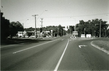
Photograph-B&W, Joan Walker, East Ringwood 2000-Taken at the cnr: Mount Dandenong Road and Dublin Road (Maroondah Hospital in the distance), 2000
East Ringwood 2000-Taken at the cnr: Mount Dandenong Road and Dublin Road (Maroondah Hospital in the distance.- B&W Photo from Album 6501 -
 Vision Australia
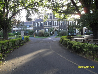
Photograph - Image, St Kilda Road building in 2010, 6/1/2010
In 2007, Vision Australia sold it's iconic 557-563 St Kilda Road site. The historic bluestone building was in need of renovation and repair, had limited space for staff and clients and with more demand for services in suburban and regional areas, did not meet the needs of the national organisation. The purchaser was mainly interested in the Ormond Hall section, which they sub-divided off and sold to the tenant of the Belgian Beer Cafe. The remainder of the site was then sold on to another developer. Unable to quickly proceed with their plans on developing the site for residential buildings, the site fell into some disrepair in the interim which was when these images were taken. Later the site was sold again and residential buildings now occupy part of the block. 20 images taken of and from St Kilda Road buildingroyal victorian institute for the blind, buildings, myer house, ferguson and urie -
 Uniting Church Archives - Synod of Victoria
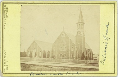
Photograph, Undated c.1880
The Wesleyan Church was located at the corner of Burwood Road and William St. Hawthorn. It was designed by Messrs. Crouch and Wilson. The foundation stone was laid by the Hon. Alexander Fraser MLC on 14 August 1867. The Sunday School next to the church was built in 1878.Sepia carte de visite photograph of the Wesleyan Methodist Church located at the corner of Burwood Road and Williams Street Hawthorn.Burwood Road, Williams Roadwesleyan church, hawthorn, crouch and wilson, hon. alexander fraser -
 Eltham District Historical Society Inc
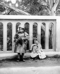
Photograph, Grace Mitchell, A young Jenni Mitchell with flowers and teddy bear on Main Road Bridge, Eltham, 1958c
Grace Mitchell was probably best known for her Eltham shop at the corner of Mt Pleasant Road and Main Road. Grace's memories covered many local identities who were patrons of her shop between 1954 and 1971. From the elevated position of her shop and home Grace was able to view a varied passing parade of Eltham events from ERSILAC, Easter and Eltham Festival parades passing on their way to Eltham Lower Park, circuses in Wingrove Park (then Bremner’s Reserve), roadworks and other happenings. Bremner's Reserve was renamed Wingrove Park c.1970 This photo of her daughter Jenni was from a series of images presented by Grace Mitchell at a Society talk 10 March 1993 on the theme of “My Eltham”. Jenni Mitchell was born 1955 according to Australian Art Sales Digest and grew up to become a noted local Eltham artist and one time Councillor.Black and white print 17 x 25.4 cmjenni mitchell, main road bridge, eltham -
 Bacchus Marsh & District Historical Society
Map, Plan of part of the road district of Bacchus Marsh circa 1856-1862
Local government in much of Victoria including the Bacchus Marsh area began with the formation of 'local committees'. These local committees could make representations to a Central Road Board regarding plans for road construction. Road construction and maintenance were seen as the essential tasks of these early local government authorities. By 1856 the local committee in Bacchus Marsh was constituted as the Bacchus Marsh Road District. This entity continued until 1862 when the name changed to the Bacchus Marsh and Maddingley Road District. This new entity lasted until 1871 when the local government authority in accordance with new statewide legislation became known as the Shire of Bacchus Marsh. The title of this plan being a plan of 'a portion of the road district of Bacchus Marsh' suggests that the plan was produced sometime between 1856 and 1862. The main purpose of this map was to shown the irrigable land in the district and the sources from which water for irrigation could be drawn. Bacchus Marsh was an early irrigation district in Victoria. Irrigation trusts were formed in the 1880s and 1890s to manage irrigation districts. But this was the culmination of many years of earlier attempts to construct irrigation systems in the Bacchus Marsh area and create a system to manage irrigation more broadly. This map dating from around 1856-1862 is an important cartographic document which provides evidence of how the early planning for irrigation was developing in the Bacchus Marsh region.A single page paper map showing a plan of part of the road district of Bacchus Marsh. The map is pasted into a bound volume containing 76 maps or plans in total. High resolution digital image stored on BMDHS computer network. bacchus marsh victoria maps, bacchus marsh road district, local government, road districts, irrigation -
 Eltham District Historical Society Inc
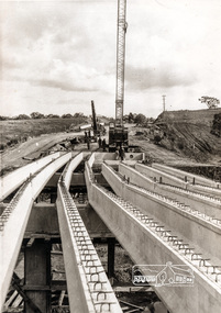
Photograph, Construction of Lower Plenty Bridge, Main Road, c.August 1966, 1966
This black and white photograph records construction activity of the then new Main Road bridge over the Plenty River at Lower Plenty in 1969.Local significanceBlack and white photograph taken during construction of the Main Road bridge over the Plenty River. Includes structural members, construction personnel, vehicles and a Clarke mobile crane.mobile cranes, bridge construction, main road, plenty river, lower plenty, bridges -
 Eltham District Historical Society Inc
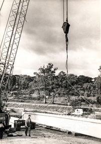
Photograph, Construction of Lower Plenty Bridge, Main Road, c.August 1966, 1966
This black and white photograph records construction activity of the then new Main Road bridge over the Plenty River at Lower Plenty in 1969.Local significanceBlack and white photograph taken during construction of the Main Road bridge over the Plenty River. Includes structural members, construction personnel, vehicles and a Clarke mobile crane.mobile cranes, bridge construction, main road, plenty river, lower plenty, bridges -
 Lakes Entrance Regional Historical Society (operating as Lakes Entrance History Centre & Museum)
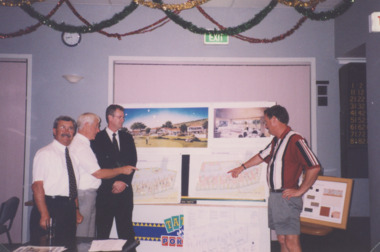
Photograph - Golf Houses residential development Golf Links Road Lakes Entrance Victoria, Lakes Post Newspaper, 1/12/1999 12:00:00 AM
Golf Houses residential development Golf Links Road Lakes Entrance Victoria - Proposed plan shown on notice boardColour photograph showing Matt Martino Bill Daniel Mike Hurst and Gary Jeal at the launch of Golf Houses residential development Golf Links Road Lakes Entrance Victoriatourism, land development -
 Mt Dandenong & District Historical Society Inc.
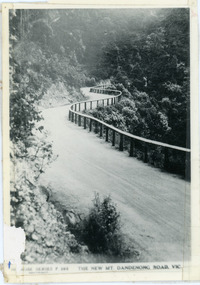
Photograph, The New Mt Dandenong Road, Vic
Copy of Rose Series postcard #385 showing the new Mt Dandenong Tourist Road with wooden railing fence on low side of road. Surface not yet made. This photograph has a detailed inscription on the back handwritten by John Lundy-Clarke in 1974.View downhill from the Windy Bend showing the site of the 1972 landslide. In this picture the road is running along the top edge of the wall 900’ thick of Kalorama Docite that plunges thousands of feet deep down into the earth below the Ranges and extends to Fern Tree Gully. It was once a horizontal terrace nearly ten miles square and tipped over to the left when the mountain subsided into its volcanic cauldron.mt dandenong road, rose series, windy bend, landslide -
 Sunbury Family History and Heritage Society Inc.
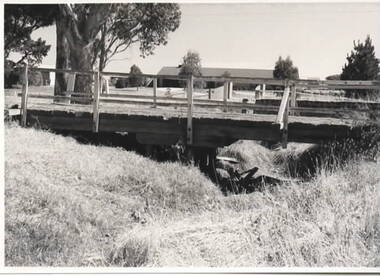
Photograph, Timber road bridge, May 1986
The small wooden bridge is spanning an arm of the Moonee Ponds Creek in its upper reaches in Greenvale near Woodlands Park, possibly along Providence Road.A non-digital black and white photograph with a white border of a timber bridge spanning a small creek, which is under a roadway. A country home is visible on the opposite side of the road.bridges, greenvale -
 Mission to Seafarers Victoria
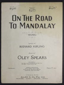
Booklet - Music Score, Allan & Co Prop Ltd, On the road to Mandalay
Original sheet music bookletRepresentative sheet music booklet of popular period Rudyard Kipling song.Paper booklet of song - sheet music and words.Title: "On The Road To Mandalay"music, sheet, mandalay, rudyard, kipling, song -
 South Gippsland Shire Council
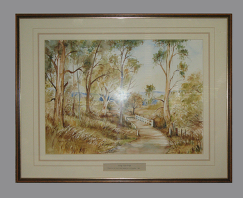
Framed watercolour painted by Bianca Biesuz, "Dryings Road Bridge", 1987
Painted by Bianca BiesuzCream card window mount with pink edging lines. Text panel cut out lower edge. Brown wood frame with gold edging. Painting portrays trees with a pathway through them, white bridge,"Dryings Road Bridge" -
 Surrey Hills Historical Society Collection
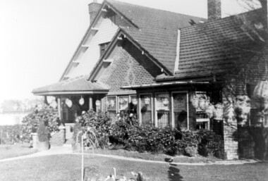
Photograph, Home and surgery of Dr William Langley Carrington, 174 Union Road, 1935
The building was erected in c 1913 as a home / surgery for Dr James L Blakie (1868-1937), who originally lived / practised across the road. It was designed by architect Arthur William Plaisted (1890-1965) and is an early example of attic-style Californian bungalow style. Dr Carrington ( 1900-1970) succeeded Dr Blakie and practised at 174 Union Road from 1930-1970. Now known as the Surrey Hills Medical Centre.Black and white photo of the surgery and home of Dr and Mrs William Langley Carrington at 174 Union Road on the corner of Guildford Road, Surrey Hills.. The exterior of the building is decorated with paper lanterns around the windows and veranda for the Empire Day celebrations in 1935. The building is 2 storey, of brick construction with a tiled roof and front porch. It has a bay window front right. Shadows indicate the photo was taken early morning in winter.medical services, guildford road, union road, dr william langley carrington, mr arthur plaisted, dr james landells blakie, californian bungalow, dr bill carrington -
 Whitehorse Historical Society Inc.
Map, Springvale Road, 1990
Aerial photograph of cnr Springvale Road and Burwood Highway, south past Highbury Road, west to Middleborough Road and east to Morack Road Vermont South.Aerial photograph of cnr Springvale Road and Burwood Highway, south past Highbury Road, west to Middleborough Road and east to Morack Road Vermont South.Aerial photograph of cnr Springvale Road and Burwood Highway, south past Highbury Road, west to Middleborough Road and east to Morack Road Vermont South.aerial photographs, morack road, vermont south, burwood highway, burwood east, springvale road, burwood east, highbury road, burwood east, burwood east, vermont south -
 Kew Historical Society Inc
Photograph, Burke Road Bridge, 1930s
Without bridges, Kew remained cut off from the City of Melbourne, only being accessible by Punt. Private and public bridges were constructed from the 1850s, beginning with the Hawthorn Bridge linking Bridge and Burwood Roads. A bridge across the Yarra at Burke Road was created as early as 1873. Since that first wooden bridge, a number of later bridges, typically on concrete pylons have been built, in 1926 and again during the 1970s.Sepia, faded photograph of the Burke Road Bridge linking East Kew and Ivanhoe. The previous bridge, constructed in 1926 was submerged beneath the flood waters in the 1934 mega-flood of the Yarra.burke road bridge (kew), bridges -- river yarra -
 Ringwood and District Historical Society
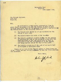
Letter, To Borough Engineer from Arthur Blood confirming gift of land adjoining Bowling Green for road-making purposes
1929 saw the establishment of the Ringwood Bowls Club initially located on the land now occupied by the Eastland Shopping Centre. It moved to its current location in Loughnan Road, Ringwood in 1997.Typed letter to Ringwood Borough Engineer from Arthur Blood confirming gift of land adjoining Bowling Green for road-making purposes. Dated 10th August 1930.city of ringwood bowls club, ringwood bowling club, ringwood bowls club, lawn bowls, bowling -
 Ringwood and District Historical Society
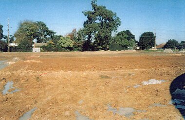
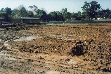
Photograph, Ringwood Bowls Club- Construction of new Bowls Club at corner of Laughnan Road and Warrandyte Road, 1996
Coloured photographPhotograph shows earthworks for greens at new Bowls Club at Laughnan Road. -
 Ringwood and District Historical Society
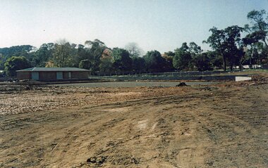
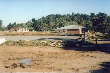
Photograph, Ringwood Bowls Club- Construction of new Bowls Club at corner of Laughnan Road and Warrandyte Road, 1996
Coloured photographPhotograph shows earthworks for greens at new Bowls Club at Laughnan Road. -
 Ringwood and District Historical Society
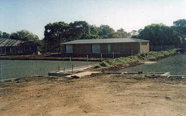
Photograph, Ringwood Bowls Club- Construction of new Bowls Club at corner of Laughnan Road and Warrandyte Road, 1996
Coloured photographPhotograph shows earthworks for greens at new Bowls Club at Laughnan Road. -
 Ringwood and District Historical Society
Photograph, Ringwood Bowls Club- Construction of new Bowls Club at corner of Laughnan Road and Warrandyte Road, 1996
Coloured photographPhotograph shows earthworks for greens at new Bowls Club at Laughnan Road. -
 Ringwood and District Historical Society
Photograph, Ringwood Bowls Club- Construction of new Bowls Club at corner of Laughnan Road and Warrandyte Road, 1996
Coloured photographPhotograph shows earthworks for greens at new Bowls Club at Laughnan Road.