Showing 3847 items
matching surveyed
-
 Bendigo Historical Society Inc.
Map - Marong County of Bendigo
Map of Marong. Drawn and reproduced at the Dept. of Lands and Survey, Melbourne. By authority: W.M. Houston Government Printer. June 1953.On the back in blue pen: certified plan parish Marong, signed minister and seal affixed for land S sec.72 evidence act. I certify that this a true plan parish Marong (signature illegible) minister for lands.map, marong -
 Bendigo Historical Society Inc.
Map - BENDIGO GOLDFIELD, 1873
BHS CollectionBendigo Goldfieds mining Lease blocks. April 1873 Topographic map. Surveyed and completed by R Brough April 1873Dept of manufacturing and Industry Development.bendigo, gold mining, mining lease blocks -
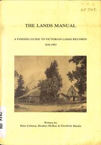 Whitehorse Historical Society Inc.
Manual - Government (Lands Dept), Royal Historical Society of Victoria, The Lands Manual - A Finding Guide to Victorian Land Records 1836 - 1983, March 1989
The manual documents the archives of the Department of Crown Lands and Survey (Lands Department) between 1836 to 1983 and explains how they can be used for historical research.The manual documents the archives of the Department of Crown Lands and Survey (Lands Department) and explains how they can be used for historical research.The manual documents the archives of the Department of Crown Lands and Survey (Lands Department) between 1836 to 1983 and explains how they can be used for historical research.crown lands, victoria. department of crown lands and survey -
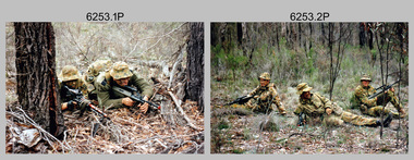 Bendigo Military Museum
Photograph - Army Survey Regiment - Regimental Training Field Phase, 1995
This is a set of twenty photographs of the Army Survey Regiment undertaking regimental training in state forest north of Costerfield, Victoria, 1995. The state forest is now part of the Heathcote-Graytown National Park. The aim of the training was to provide personnel practical revision of infantry and minor tactics at the section level, navigation and map reading, RATEL and Survival in the Field. This was the Army Survey Regiment’s last military skills field training exercise before disbandment of RA Svy and the weather on the last day was wet and cold. It provided soldiers who decided to continue their military service essential military skills revision and for those who chose to discharge from the Army, it reinforced their decision to leave. LTCOL Duncan Burns was the last CO of the Army Survey Regiment from 1994 to 1996 and WO1 Ken Johnston OAM MM from RA Inf was the RSM for one year in 1995.This is a set of twenty photographs of the Army Survey Regiment undertaking regimental training in state forest north of Costerfield, Victoria, 1995. The photographs were printed on photographic paper and are part of the Army Survey Regiment’s Collection. The photographs were scanned at 300 dpi. .1) - Photo, colour, 1995, unidentified personnel. .2) - Photo, colour, 1995, L to R: Derek Percival, Damien Cole, unidentified. .3) - Photo, colour, 1995, L to R: unidentified, Chris ‘Charlie’ Brown, unidentified (x2). .4) - Photo, colour, 1995, unidentified personnel. .5) - Photo, colour, 1995, unidentified. .6) - Photo, colour, 1995, unidentified personnel. .7) - Photo, colour, 1995, unidentified personnel. .8) - Photo, colour, 1995, L to R: Jim Ash, Syd Anstee, unidentified, Rob Bogumil. .9) & 10) - Photo, colour, 1995, L to R: Steve Hill OAM CSM, Rob Bogumil, Brian Paul, Jim Ash, Syd Anstee, Colin Davidson. .11) - Photo, colour, 1995, L to R: Paul ‘Hutch’ Hunter, Stu Ridge, Chris ‘Charlie’ Brown. .12) - Photo, colour, 1995, RSM WO1 Ken Johnston OAM MM. .13) - Photo, colour, 1995, Peter Imeson. .14) - Photo, colour, 1995, L to R: Stu Ridge, Alan Virtue. .15) - Photo, colour, 1995, CO LTCOL Duncan Burns. .16) - Photo, colour, 1995, unidentified personnel. .17) - Photo, colour, 1995, L to R: Tony Harder, CAPT Sutiman (Indonesian Exchange Officer), Kasey ‘Tiges’ Northausen, unidentified (x2), Mick Duggan. .18) - Photo, colour, 1995, CAPT Sutiman (Indonesian Exchange Officer). .19) & 20) - Photo, colour, 1995, unidentified personnel..1P to .20P – No personnel are identified.royal australian survey corps, rasvy, army survey regiment, army svy regt, fortuna, asr -
 Flagstaff Hill Maritime Museum and Village
Document - Navigation Chart, Admiralty Office, Lady Bay and Warrnambool Harbour, 03/04/1871
This Chart titled “Lady Bay and Warrnambool Harbour” was surveyed by Nav. Lieut. H.J. Stanley, of Britain's Royal Navy, in 1870 and printed in April 1871. The chart was made before the Warrnambool Breakwater was built (construction had begun in 1874 and was completed in 1890). The chart includes Directions for entering Lady Bay, Warrnambool Harbour. These are "Vessels entering Warrnambool Harbour must bring the Red Light in sight and steer in with it in line with the upper white Light bearing North, until the Green Light on the Jetty is opened, when steer towards it and anchor. The best anchorage is in 2 ¼ fms [fathoms)] of water, about a cable from ledge off Breakwater rock. Or where convenient, according to draught of water, only endeavouring to anchor as close as possible to Breakwater rock. It is not safe to enter or leave the Harbour in south westerly or Southerly gales.” This chart is significant for its strong connection to the maritime history of Warrnambool Harbour and Lady Bay, and eventually to the Warrnambool Breakwater. The Warrnambool Breakwater is registered as a place of significance on the Victorian Heritage Database (VHR H2024). A copy of the same chart was used to plan several submissions for future changes to the jetty and breakwater. The chart is a historical record of structures existing in 1870; the Warrnambool Jetties, Lady Bay, the leading lights (lighthouses), streets, roads, bridges and many buildings. It also shows the lay of the land and seabed.Canvas chart of Australia, South Coast, Victoria Title: Lady Bay and Warrnambool Harbour Surveyed by Nav. Lieut. H.J. Stanley, R.N., 1870. Magnet Variation, 1870 Published April 3, 1871, by the Admiralty, London. Directions for vessels entering Warrnambool Harbour are printed on the chart. The chart has a lacquer or seal over it.Top of chart has logo "HYDROGRAPHER OFFICE" "Price Eighteen Pence". "Engraved by Edward Weller" Along bottom of Chart: “London… Published at the Admiralty, 3rd April 1871, under the Superintendence of Rear Admiral G.H. Richards, F.R.S. Hydrographer, Corrections July 71” Bottom of chart “Australia South Coast Victoria Lady Bay and Warrnambool Harbour. 2494”flagstaff hill, warrnambool, chart of lady bay warrnambool 1870, warrnambool harbour, cartography, navigation, warrnambool breakwater, 1871, australia – south coast / victoria, lady bay, 1870, nav. lieut. h.j. stanley, r.n, directions for entering warrnambool harbour, hydrographer office, rear admiral g.h. richards, edward weller, port of warrnambool, flagstaff hill maritime museum & village, maritime museum, maritime village, shipwreck coast, map, chart, navigation chart, admiralty chart, breakwater, jetty, pier, vhr h2024 -
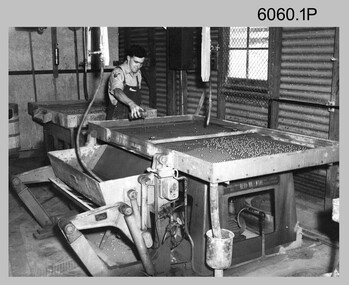 Bendigo Military Museum
Photograph - Lithographic Technicians Preparing Printing Plates at the Army Survey Regiment, c1960s to c1980s
These eight photographs were most likely taken from the 1960s to the 1980s in Lithographic Squadron at the Army Survey Regiment, Fortuna, Bendigo. Photos .1P, .7P, and .8P are not annotated although .7P and .8P are positively identified. The others have the name of the technicians written on the back. In these photos the technician preparing printing plates for offset printing. The Printing Technician in photo .1P is resurfacing a zinc printing plate with ball bearings. In photos .2P to .6P the Printing Technicians are applying a light sensitive coating on the printing plate. In photos .7P and .8P the Printing Technicians are placing a map negative on top of the printing plate in a vacuum frame before light exposure. This is a set of photographs of lithographic technicians preparing printing plates at the Army Survey Regiment, Bendigo from c1960s to c1980s. The photographs were printed on photographic paper and are part of the Army Survey Regiment’s Collection. The photographs were scanned at 300 dpi. .1) - Photo, black & white, c1960s, SPR Bruce, Lithographic Squadron .2) - Photo, black & white, c1970s, Lance Percey, Lithographic Squadron .3) - Photo, black & white, c1970s, LCPL Col Hardisty, Lithographic Squadron .4) - Photo, black & white, c1970s, SPR Dave Edwards, Lithographic Squadron .5) - Photo, colour, c1970s, John Cain, Lithographic Squadron .6) - Photo, colour, c1970s, SGT Ken Slater, Lithographic Squadron .7) - Photo, black & white, c1980s, Roy Hicks, Lithographic Squadron .8) - Photo, black & white, c1980s, CPL Gary Drummond, Lithographic Squadron.1P - annotated 'SPR Bruce' on back of dupicate photo located in Volume 7 folder. .2 to .7 – personnel names (less rank) annotated on back. .8P – no annotationroyal australian survey corps, rasvy, army survey regiment, army svy regt, fortuna, asr, printing, litho -
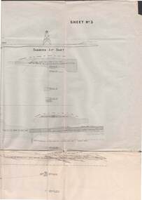 Bendigo Historical Society Inc.
Map - STRUGNELL COLLECTION: UNDERGROUND SURVEY OF MINES BENDIGO
Map, Underground Survey of Mines, Bendigo, New Chum Railway Reef, Shenandoah Co's Shaft, Shamrock Co's Shaft.Young Chum Reef, Thorpe's Reef, Shenandoah Reef, Consolidated Reef, Sheet 3.Survey under the Supervision of H.Herman. Drawing shows mine shafts to over 3100 feet deepmap, bendigo, shamrock & shenandoah co's -
Bendigo Historical Society Inc.
Map - FRED COWIE COLLECTION: AERIAL MAPS OF HEATHCOTE/EPPALOCK, 28-9-1960
Map, Heathcote C2, Township of Heathcote, Melbourne Road through town branching off to Bendigo & Echuca. Aerial Survey of Victoria. Photo-map prepared by Department of Crown Lands and Survey from photographs taken in 1960. Copied photographically at the Central Plan Office.Fred Cowie,46 McIvor Rd,Bgo..Central Plan Officemap -
 Bendigo Military Museum
Photograph - Co-ordinatorgraph Map Grid Production, Army Survey Regiment, Fortuna Bendigo, c1960s to 1970s
This is a set of seven photographs of map grid production using co-ordinatorgraphs at the Army Survey Regiment, Fortuna Bendigo. c1960s to 1970s. The Aristo Co-ordinatorgraph introduced in 1962 was a large heavy steel framed light table with a scribing head that moved in a XY direction using a vernier calibrated measuring scale to 0.001 of an inch. Whilst hand operated it was much quicker and accurate than manual grid and graticule calculation, plotting and scribing. Mapping PNG presented the Regiment with many challenges. WO1 Farrington and CPL John Dean developed computer software for the digitally controlled co-ordinatorgraph, the Calcomp 718 Flatbed Plotter. Much time was saved by automatically plotted cartographic grids and graticules, and automatically draw base compilation sheets complete with aerial triangulated stereo model control. This could be used for a number of maps and was the first step towards map automation. The history of co-ordinatorgraphs is covered in more detail with additional historic photographs, in pages 50 to 51 and page 88 of Valerie Lovejoy’s book 'Mapmakers of Fortuna – A history of the Army Survey Regiment’ ISBN: 0-646-42120-4. SGT Bill Boyd appearing in photo .1P reach the rank of WO1 and for 11 years was the technical warrant officer at the Detachment Army Survey Regiment located at Bonegilla, Victoria. He was awarded the OAM, the Order of Australia Medal for the development of the Flexiflow quality control system. This system comprised a series of job plans and charts linked to a task allocation to resource magnetic planning board. Using critical path analysis and task prioritisation, complex job planning was efficiently scheduled, and re-prioritisations readily made. Reproduction requirements were effectively coordinated by way of weekly courier to the Army Survey Regiment. Supervisors and technicians fully embraced the system as they could understand their role, others around them and the positive production achievements. Bendigo. See page 178 of Valerie Lovejoy’s book for more information on WO1 Boyd’s contribution to RA Svy.This is a set of seven photographs of map grid production using co-ordinatorgraphs at the Army Survey Regiment, Fortuna Bendigo. c1960s to 1970s. The photographs were printed on photographic paper and are part of the Army Survey Regiment’s Collection. The photographs were scanned at 300 dpi. .1) - Photo, black & white, c1960s, L to R: SGT Bill Boyd demonstrating Aristo Co-ordinatorgraph equipment to unidentified technicians (x3) .2) - Photo, black & white, c1960s, Aristo Co-ordinatorgraph equipment. .3) - Photo, black & white, c1960s, unidentified technician operating Aristo Co-ordinatorgraph equipment. .4) - Photo, black & white, c1960s, L to R: PTE Desi Asaris and CPL Kalen Sargent operating Aristo Co-ordinatorgraph equipment. .5) - Photo, black & white, Photo, black & white, c1970s, John Bloor operating Calcomp co-ordinatorgraph equipment. .6) - Photo, black & white, Photo, black & white, c1970s, unidentified technician operating Calcomp co-ordinatorgraph equipment. .7) - Photo, black & white, Photo, black & white, c1970s, L to R: SGT Andy Covington and SGT John Waight operating Calcomp co-ordinatorgraph equipment..7P annotated on back ‘Covington & Waight’.royal australian survey corps, rasvy, army survey regiment, army svy regt, fortuna, asr, carto, air survey -
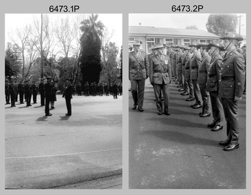 Bendigo Military Museum
Photograph - Army Survey Regiment – Commanding Officer Handover Parade, Fortuna Villa, Bendigo, 1985
These photographs were taken at a Commanding Officer Handover Parade at the Army Survey Regiment, Bendigo in 1985. CO LTCOL Jorge Gruszka was the CO of the Army Svy Rgt from 1982 to 1985 and handed over CO LTCOL Don Swiney MBE. CO LTCOL Swiney’s appointment was from 1985 to 1987. See item 6077.6P for additional photos taken at the parade.This is a set of 14 photographs of a Commanding Officer Handover Parade at the Army Survey Regiment, Bendigo in 1985. The photographs are on 35mm negative film and scanned at 96 dpi The photographs are part of the Army Survey Regiment’s Collection. .1) - Photo, black & white, 1985, HQ Squadron inspection. L to R: MAJ Daryl Hockings CSM, CO LTCOL Jorge Gruszka. .2) - Photo, black & white, 1985, HQ Squadron inspection. L to R: MAJ Daryl Hockings CSM, MAJ Bob Roche, CO LTCOL Jorge Gruszka, unidentified personnel, 2nd right, WO2 Alan Bunn, far right WO2 Tom Pattison. .3) - Photo, black & white, 1985, Air Survey Squadron inspection. L to R: MAJ Kym Weston, CO LTCOL Jorge Gruszka. .4) - Photo, black & white, 1985, Squadron inspection. L to R: MAJ Terry Edwards, CO LTCOL Jorge Gruszka, unidentified officer, RSM WO1 Bob Mason, MAJ Bob Roche. .5) - Photo, black & white, 1985, Squadron inspection. L to R: MAJ Terry Edwards, CO LTCOL Jorge Gruszka, unidentified officer, RSM WO1 Bob Mason, MAJ Bob Roche, SGT Paul Hopes, unidentified. CPL Roger Pearson. .6) - Photo, black & white, 1985, Lithographic Squadron inspection. L to R: CO LTCOL Jorge Gruszka, MAJ Mick Byrne. .7) - Photo, black & white, 1985, Lithographic Squadron inspection. L to R: MAJ Mick Byrne, CO LTCOL Jorge Gruszka, Front rank L to R: CPL Greg Rowe, CPL Ken Peters, CPL Paul Davis, CPL Paul Baker, SSGT Peter Barrett, SGT Gavin Neilson. Centre rank L to R: CPL Peter Breukel, CPL Le-Anne (Smallshaw) Shirley, SPR Bronwyn Jones. .8) - Photo, black & white, 1985, L to R: CO LTCOL Jorge Gruszka, RSM WO1 Bob Mason. .9) - Photo, black & white, 1985, L to R: LTCOL Don Swiney MBE, RSM WO1 Bob Mason, CO LTCOL Jorge Gruszka. .10) - Photo, black & white, 1985, L to R: New CO LTCOL Don Swiney MBE, outgoing CO LTCOL Jorge Gruszka. .11) - Photo, black & white, 1985, L to R: New CO LTCOL Don Swiney MBE, outgoing CO LTCOL Jorge Gruszka. .12) - Photo, black & white, 1985, L to R: 2IC Bob Roche, New CO LTCOL Don Swiney MBE. .13) - Photo, black & white, 1985, New CO LTCOL Don Swiney MBE takes command of the Army Survey Regiment. RSM WO1 Bob Mason in background. .14) - Photo, black & white, 1985, New CO LTCOL Don Swiney MBE takes command of the Army Survey Regiment. L to R: outgoing CO LTCOL Jorge Gruszka, ADJT CAPT Doug Maxwell.No personnel are identified. Date and occasion annotated on film negative sleeve.royal australian survey corps, rasvy, army survey regiment, army svy regt, fortuna, asr -
 Bendigo Military Museum
Photograph - AUTOMAP 1 Production – Army Survey Regiment, Fortuna, Bendigo, c1978-1980
This collection of 17 photos was most likely taken in c1978-1980. The AUTOMAP 1 computer assisted cartography and mapping system was introduced in 1975. The components of AUTOMAP 1 were the Input Sub-System of four Wild B8s stereoplotters and three Gradicon digitising tables, the Optical Line Following Sub-System – Gerber OLF, the Verification Sub-System – Gerber 1442 drum plotter, the General Purpose Sub-system – HP21MX computer and the Output Sub-System – Gerber 1232 flatbed plotter). The first map was published in 1978 (Strickland 3665-3, 1:50,000). AUTOMAP 1 was the first computer assisted cartography and mapping system utilised by the Survey Corps and was the first system used by Australian mapping organisations. The history of the AUTOMAP 1 system is covered in more detail with additional historic photographs, in pages 116-118 of Valerie Lovejoy’s book 'Mapmakers of Fortuna – A history of the Army Survey Regiment’ ISBN: 0-646-42120-4. See items 6122.20P, 6410.24P, 6183.19P, 6184.20P, and 6200.5P for additional photographs of the AUTOMAP 1 system.This is a set of 17 photographs of Air Survey Squadron military and civilian personnel operating AUTOMAP 1 equipment at the Army Survey Regiment at Fortuna, Bendigo, c1978-1980. The photographs were on 35mm colour slides and were scanned at 96 dpi. They are part of the Army Survey Regiment’s Collection. .1) - Photo, colour, c1978-1980, Gerber 1442 verification drum plotter. .2) - Photo, colour, c1978-1980, Gerber 1442 verification drum plotter, SPR Garry Ames. In background - Hewlett Packard (HP) 2100A Minicomputer Input Subsystem controlling Wild B8 Aviograph stereo plotters. .3) - Photo, colour, c1978-1980, Gerber 1442 verification drum plotter. .4) - Photo, colour, c1978-1980, digitising topographic features with a Wild B8 Aviograph stereo plotter, CPL Adrian Rynberk. .5) to .6) - Photo, colour, c1978-1980, Wild PEB8 stereo profiler. .7) - Photo, colour, c1980, HP 9640A Programming System. .8) - Photo, colour, c1980, HP 9640A Programming System, L to R: unidentified, SGT Alan Toogood. .9) - Photo, colour, c1978-1980, Gerber Optical Line Follow (OLF), CAPT Rob Bridge. .10) - Photo, colour, c1978-1980, Gerber OLF. .11.) to .12) - Photo, colour, c1978-1980, Gerber OLF, SPR Gerry Gunn. .13) - Photo, colour, c1978-1980, Gerber OLF. .14) - Photo, colour, c1979, Gradicon edit table. .15) to .16) - Photo, colour, c1981, Gradicon edit table, SPR Chris Gordon. .17) - Photo, colour, c1981, Gradicon edit table, L to R: SPR Chris Brown, unidentified..1P to .17P - Some of the equipment is annotated on the frame of the 35mm slides.royal australian survey corps, rasvy, army survey regiment, army svy regt, fortuna, asr, automap 1 -
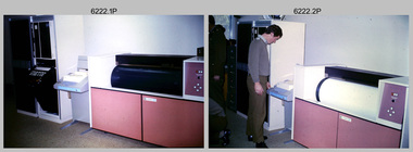
 Bendigo Military Museum
Photograph - AUTOMAP 1 Production – Army Survey Regiment, Fortuna, Bendigo, c1979
This collection of 19 photos was most likely taken in 1980. The AUTOMAP 1 computer assisted cartography and mapping system was introduced in 1975. The components of AUTOMAP 1 were the Input Sub-System of four Wild B8s stereoplotters and three Gradicon digitising tables, the Optical Line Following Sub-System – Gerber OLF, the Verification Sub-System – Gerber 1442 drum plotter, the General Purpose Sub-system – HP21MX computer and the Output Sub-System – Gerber 1232 flatbed plotter). The first map was published in 1978 (Strickland 3665-3, 1:50,000). AUTOMAP 1 was the first computer assisted cartography and mapping system utilised by the Survey Corps and was the first system used by Australian mapping organisations. The history of the AUTOMAP 1 system is covered in more detail with additional historic photographs, in pages 116-118 of Valerie Lovejoy’s book 'Mapmakers of Fortuna – A history of the Army Survey Regiment’ ISBN: 0-646-42120-4. See items 6122.20P, 6410.24P, 6184.20P, 6200.5P, and 6222.17P for additional photographs of the AUTOMAP 1 system.This is a set of 19 photographs of Air Survey Squadron military and civilian personnel operating AUTOMAP 1 equipment at the Army Survey Regiment at Fortuna, Bendigo, c1979. The photographs were on 35mm negative film and were scanned at 96 dpi. They are part of the Army Survey Regiment’s Collection. .1) - Photo, colour, c1979, Gradicon edit table, SSGT John Bennett. .2) - Photo, colour, c1979, Gradicon edit table. .3) - Photo, colour, c1979, HP21MX computer General Purpose Sub-system. .4) - Photo, colour, c1979, HP21MX computer General Purpose Sub-system. L to R: CAPT Graham Baker, SPR Ian Belmont. .5) - Photo, colour, c1979, Gerber verification drum plotter. 1130 System administration, unidentified. .6) - Photo, colour, c1979, Gerber Optical Line Follower (OLF). .7) - Photo, colour, c1979, Gerber OLF .8) - Photo, black & white, c1979, Programming and system administration, L to R: WO1 Don Taylor, Robert Cox, Tony Spurling, SSGT John Bennett, SGT Alan Toogood. .9) to .14) - Photo, black & white, c1979, .15) - Photo, black & white, c1979, Gerber OLF, unidentified. .16) - Photo, black & white, c1979, Gerber verification drum plotter, unidentified using Gradicon edit table. .17) to .18) - Photo, black & white, c1979, - Photo, black & white, c1979, Programming and system administration, SSGT John Bennett. .19)- Photo, black & white, c1979, - Photo, black & white, c1979, HP21MX computer General Purpose Sub-system..1P to .19P No personnel are identified.royal australian survey corps, rasvy, army survey regiment, army svy regt, fortuna, asr, automap 1 -
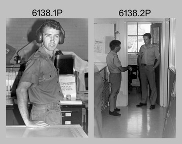 Bendigo Military Museum
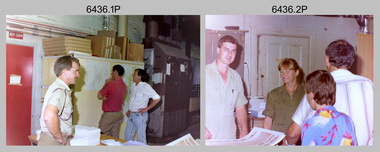
Photograph - Staff Activities – Lithographic Squadron, Army Survey Regiment, Fortuna, Bendigo, 1990
This collection of 14 photos was most likely taken in Lithographic Squadron at the Army Survey Regiment, Fortuna, Bendigo, in 1990. The photos were mainly taken in the Camera, Contacting Printing BARCRO and Production Control work areas, as well as outside the buildings. Although these photos are not annotated most personnel are positively identified. This is a set of 14 photographs of Lithographic Squadron and staff from other squadrons undertaking various tasks at the Army Survey Regiment, Fortuna, Bendigo, 1990. The photographs were on 35mm negative film and were scanned at 96 dpi. They are part of the Army Survey Regiment’s Collection. .1) - Photo, black & white, 1990, Damien Cole .2) - Photo, black & white, 1990, L to R: SGT Keith Quinton, CAPT Bill Jones. .3) - Photo, black & white, 1990, Andrew Morrison-Evans. .4) - Photo, black & white, 1990, John Bragg. .5)- Photo, black & white, 1990, CPL Stuart Ridge. .6) - Photo, black & white, 1990, Ken Delmenico. .7) - Photo, black & white, 1990, Ken Labouchardiere. .8) - Photo, black & white, 1990, CPL Peter Dillon. .9) - Photo, black & white, 1990, L to R: WO1 Ralph Chant, SSGT Rhys De Laine. .10) - Photo, black & white, 1990, CPL Darren Maher. .11) - Photo, black & white, 1990, CPL John ‘Flash’ Anderson. .12) - Photo, black & white, 1990, L to R: CPL SGT Gary Kerr, CPL Lance Strudwick, SGT Dale Hudson. .13) - Photo, black & white, 1990, LT Craig Hersant and Alf. .14) - Photo, black & white, 1990, MAJ Bob Coote.No personnel are identifiedroyal australian survey corps, rasvy, army survey regiment, army svy regt, fortuna, asr, litho -
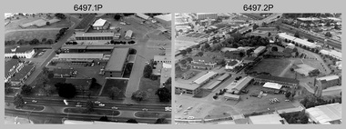 Bendigo Military Museum
Photograph - Military Establishments located in South Australia, c1986
This is a set of 20 oblique angled photographs of military establishments located in South Australia circa 1986. 4th Field Survey Squadron located in Keswick Barracks Adelaide, features in photos .1P to .6P. Warradale Barracks, Adelaide features in photos .7P to .10P. Woodside Barracks features in photos .11P to .14P. The military establishment featured in photos .15P to .20P is unknown.This is a set of 20 oblique angled photographs of military establishments located in South Australia circa 1986. The black & white photographs are on 35mm negative film and are part of the Army Survey Regiment’s Collection. The photographs were scanned at 96 dpi. .1) to .6) - Photo, black & white, 1986. Keswick Barracks, Adelaide, SA. .7) to .10) - Photo, black & white, 1986. Warradale Barracks, Adelaide, SA. .11) to .14) - Photo, black & white, 1986. Woodside Barracks, SA. .15) to .20) - Photo, black & white, 1986. Unknown location, SA. .1P to .20P – ‘Keswick, Warradale and Woodside’ annotated on negatives sleeve.royal australian survey corps, rasvy, 4 fd svy sqn -
 Bendigo Military Museum
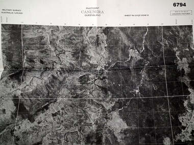
Map - MAP, CUNUNGRA, QLD, Royal Aust. Survey Corps, 1955
Canungra was the Jungle Warfare Training Centre (JTC) before and including 1968. Item in the collection re Lt.Col. Swatton refer Cat No 6719.2P for his service details.This is a full size air photo map. It is black and white. Some natural features are labelled with white printing. The air photo has a white border of approx 6.5 cms size. Map information is printed in black ink around all four borders.Map data = Military survey Australia 1:25,999 Sheet No. 213/2 Zone 8. Scale 1:25,000. Date = The air photo was taken Jan 1955. Map produced by R.A. Survey Corps 1955.passchendaele barracks trust, survey map -
Bendigo Historical Society Inc.
Map - FRED COWIE COLLECTION: AERIAL MAPS OF HEATHCOTE/EPPALOCK, 28-9-60
Map, Heathcote C4, Aerial Survey of Victoria,Photo-map prepared by Department of Crown Lands and Survey from photographs taken in 1960. Copied photographically at the Central Plan Office.Date 28-9-60,C.P.O.Neg.No.21590.Scale 4 inches to 1 mile. Fred Cowie,46 McIvor Rd,Bgo..Central Plan Office.map -
 Bendigo Historical Society Inc.
Document - INVITATION TO ARMY SURVEY REGIMENT CORPS DAY PARADE, 1 JULY, 1985
Cream bifold invitation. On front, coat of arms of City of Bendigo and Royal Australian Survey Corps. Inside 'His worship the Mayor of the City of Bendigo requests the company of Mr and Mrs M.A. Sheean at the Army Survey Regiment Corps Day Parade, Queen Elizabeth Oval, 10.00 a.m, 1 July 1985.bendigo, entertainment, army survey corps -
 Ballarat Tramway Museum
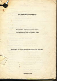
Document - Report, Tramway Museum Society of Victoria (TMSV), "Provisional Demand Analysis of the Urban Ballarat Bus Catchment Area", Feb. 1978
67 page document on the results of surveys done on Ballarat passenger services in late 1977 and early 1978, dated 2/78. Has survey forms, procedures, questionnaire, results etc. Table of contents, appendices. Printed onto duplicating paper. Single metal paper fastener in top left hand corner.trams, tramways, ballarat, bus services, surveys -
 Bendigo Historical Society Inc.
Card - FORTUNA COLLECTION: CARD
Christmas Card - colour printed sketch of fortuna Villa showing partial view of driveway, portico entrance on left, turret tower, ironwork balcony and conservatory on right. Wording inside card reads ' Seasons Greetings from Army Survey Regiment Fortuna'. On rear of card is a 'Royal Australian Survey Corps insignia. -
 Bendigo Military Museum
Photograph - Army Survey Regiment Open Day – Lithographic Squadron, Fortuna, Bendigo, 1990
These 18 photographs were taken at an Army Survey Regiment Open Day at Fortuna Villa, Bendigo on the 24th of February 1990. This occasion was one of several events held to commemorate the 75th anniversary of the formation of the Royal Australian Survey Corps. Although historical tours of Fortuna occurred on a regular basis, this was the first technical open day since 1972. The Royal Australian Survey Corps recognised that an Open Day was the best way for the local community in Bendigo to gain an insight into the unit’s important role as Defence’s map production agency, its technical equipment, and its economic importance to Bendigo. It also gave them an opportunity to tour through historic Fortuna Villa. This occasion is covered in more detail in page 143 of Valerie Lovejoy’s book 'Mapmakers of Fortuna – A history of the Army Survey Regiment’ ISBN: 0-646-42120-4. Refer to items 6434.27P and 6435.35P for more photos of the Open Day taken inside Fortuna, the garden areas and Map Production areas of Air Survey and Cartographic Squadron. Photo prints of some of these photos were scanned and catalogued in items 6247.30P and 6291.6P.These 18 photographs were taken at an Army Survey Regiment Open Day held at Fortuna, Bendigo on the 24th of February 1990. The 35mm colour and black & white negatives photographs were scanned at 96 dpi and are part of the Army Survey Regiment’s Collection. .1) - Photo, colour, 1990. Print Troop – WO2 Rob Bogumil with visitors. .2) - Photo, colour, 1990. Print Troop – L to R: SPR Ross Anza, LCPL Janet Murray with visitors. .3) - Photo, black & white, 1990. Print Troop – L to R: LCPL Janet Murray, MAJ Bob Coote, SPR Gary Lord with visitors. .4) - Photo, black & white, 1990. Photo Troop – L to R: WO2 Keith Fenton RE UK Exchange, SGT Steve Burke with visitors. .5) - Photo, colour, 1990. Photo Troop – SGT Steve Burke with visitors. .6) - Photo, colour, 1990. Photo Troop – L to R: unidentified, SGT Steve Burke with visitors. .7) - Photo, colour, 1990. Print Troop – L to R: CPL Peter Breukel, WO2 Keith Fenton RE. UK Exchange with visitors. .8) - Photo, black & white, 1990. Photo Troop - WO2 Keith Fenton RE. UK Exchange. .9) - Photo, black & white, 1990. Print Troop - civilian visitors. .10) - black & white, Print Troop, 1990. - L to R: civilian visitors, SSGT Ian Nichols, CPL John ‘Flash’ Anderson. .11) - Photo, black & white, 1990. Print Troop - L to R: SSGT Ian Nichols, CPL Dale Hudson, Planeta printing press, with civilian visitors. .12) - Photo, colour, 1990. Print Troop - L to R: SSGT Ian Nichols, CAPT Roger Hancock with civilian visitors. .13) - Photo, colour, 1990. Print Troop - LT Marty Lyons with civilian visitors. .14) - Photo, black & white, 1990. Print Troop - L to R: LT Marty Lyons, unidentified with civilian visitors. .15) - Photo, black & white, 1990. Orthophoto Mapping Section - L to R: SSGT Peter Imeson, SGT Bob Garritty with civilian visitors. .16) - Photo, colour, 1990. Optronics raster scanner - WO2 Adrian ‘Charlie’ Creedy with civilian visitors. .17) - Photo, colour 1990. Outside Photo Troop office - L to R: SSGT Rhys De Laine, WO2 Rob Bogumil. .18) - Photo, black & white, 1990. Photo Troop - civilian visitors..1P to .18P – no annotationsroyal australian survey corps, rasvy, army survey regiment, army svy regt, fortuna, asr, litho sqn -
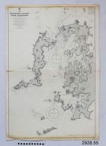 Flagstaff Hill Maritime Museum and Village
Document - Navigation Chart, Pescadores Islands Inner Anchorage
British Admiralty Navigation Chart - China - Formosa Strait - Pescadores Islands Inner Anchorage, from a French Goverment Survey 1886warrnambool, shipwrecked-coast, flagstaff-hill, flagstaff-hill-maritime-museum, maritime-museum, shipwreck-coast, flagstaff-hill-maritime-village, shipwrecked-artefact, navigation chart, british admiralty navigation chart, british admiralty, pescadores islands inner anchorage -
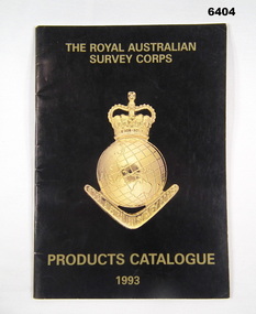 Bendigo Military Museum
Booklet - PRODUCTS CATALOGUE 1993, RASvy Corps, Royal Australian Survey Corps. Products Catalogue1993, 1993
This Catalogue contains details on the products and capabilities available from the RASvy CorpsA4 Booklet black cover, Survey Corps badge in Gold. Sample maps of all products produced by RASvy Corps 1993rasvy, fortuna -
 Bendigo Military Museum
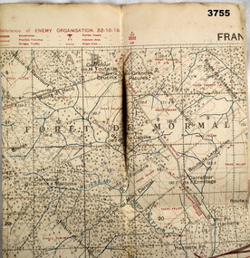
Map - TRENCH MAP WW1, 1918
Area of map shows the River Sambre running from corner left to top corner right, Landrecies, Hachette, Petit Paris to Leval. Item re William Alexander No 502 AIF. refer cat No 3746.3 for his service details.Map, Enemy rear Organization France, Edition 3a, sheet 57A N.W, scale 1:20,000, Field Survey to 24.10.1918.Hand written on rear in black, “57A N.W”map, france, trench -
Federation University Historical Collection
Formulae Mine Surveying
Formulae for the various calculations involved in Mining Surveying - areas, volumes, weights, chain strength, loads, Columns, angles, side lengthsmine surveying, survey -
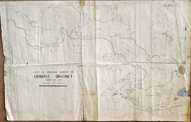 Orbost & District Historical Society
survey, 26th July 1950
This map is a research tool for identifying historical land records in Orbost.A copy of the original survey of Orbost District 1870. White background with black print. The original was hand-drawn in ink. This is PLATE 1.some pen marksmap survey-orbost -
 Bendigo Historical Society Inc.
Document - FORTUNA COLLECTION: ARTICLE: ARMY HEADQUARTERS SURVEY REGIMENT (FORTUNA)
Article re 'Army Headquarters Survey Regiment' (Fortuna) - welcome to an Open Day at Fortuna, 1967. Two handwritten pages (drafts?).bendigo, house, fortuna villa, army headquarters survey regiment. -
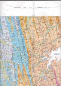 Bendigo Historical Society Inc.
Map - STRUGNELL COLLECTION: GEOLOGICAL SURVEY OF VICTORIA, BENDIGO GOLD FIELD - SPRING GULLY, 1987
Map, Geological Survey of Victoria, Bendigo Gold Field - Spring Gully, Campaspe 10 000 2/1; Victoria 10,000.Cept. Of Industry, Technology & Resources.map, bendigo, spring gully gold field -
Port Melbourne Historical & Preservation Society
Letter - Department of Lands and Survey granting land for temporary reserve, 18 Mar 1860
Handwritten letter from Dept of Lands and Survey granting Crown land for temporary reserve as site for abattoirs 18 March 1861local government - borough of sandridge, industry - noxious, department of lands and surveys, clement hodgkinson -
Tatura Irrigation & Wartime Camps Museum
Booklet, Solving The Mystery, 1978
Story of Tatura Catholic Church and Education. Early history of Tatura 1870's. Present church built in 1912Gold cover, green writing. Survey map on back. Written to explain the first Catholic Church was built at Baldwinsville-Byrneside in 1878.solving the mystery, catholicism in tatura, burton-clay father r, tatura, sacred heart church, books, history, local, religion -
Lakes Entrance Regional Historical Society (operating as Lakes Entrance History Centre & Museum)
Book, Reed, G.H. M.A, A Book of Architecture, 1930
A survey of architecture through the ages, with illustrations describing styles, ornamentation and historical development. A short reference to Sir Christopher Wren is included.Ruth Clarkarchitecture, social history, religion, arts