Showing 1526 items
matching aerial photograph
-
 City of Kingston
Photograph - Black and white, 20 December 1945
... Aerial photograph dated 1945 of the Cheltenham area...: 57197 Aerial photograph dated 1945 of the Cheltenham area ...This photograph depicts a section of Cheltenham with a mix of housing and market gardens. The visible market gardens, farms and paddocks have gradually been sub-divided into housing, commercial and industrial estates. A large part of Cheltenham was originally established as a rural market gardening community. The railway line and station brought urban development to the area and the gradual subdivision of farmland and large land holdings for the development of housing. Aerial photograph dated 1945 of the Cheltenham area in the City of Kingston. Sydney Street (bottom left); Sinclair Street (top left); Weymar Street area off Wilson Street, Charles Street (botton right).White print VIC-170; 57197; RUN5; PROJ.No.5; MELB.METROP AREA Lens information [indecipherable] Small photograph: clockface Black ink: 57197cheltenham, market gardens, urbanisation -
Glenelg Shire Council Cultural Collection
Photograph - Photograph - Portland Harbour with oil rig, c. 1966
... onto white paper and attached to rear of photo, " Aerial... paper and attached to rear of photo, " Aerial photograph ...Port of Portland AuthorityBack: harb019 Portland Harbour Trust 7 - black pen. Typed onto white paper and attached to rear of photo, " Aerial photograph of Portland Harbour depicts the development and growth in port trade since the first stage of construction was sompleted in Novemer, 1960."port of portland archives, portland harbour, oil rig -
 Nhill Aviation Heritage Centre
Black and White photograph, Possibly Dept of Defence photograph, Nhill RAAF Base
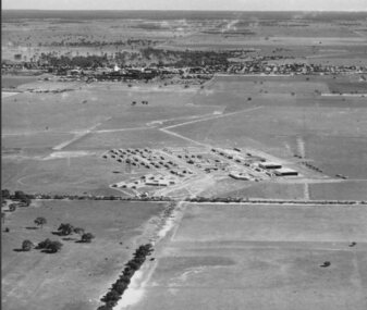
... Aerial photograph of the Nhill RAAF base thought... to be the first aerial photo taken of the RAAF Base. raaf 1941 base Aerial ...The Nhill RAAF Base was built during WWII as part of the Empire Air Training Scheme (EATS Scheme)This is believed to be the first aerial photo taken of the RAAF Base. Aerial photograph of the Nhill RAAF base thought to be taken late 1941 or early 1942. Notice that only two of five Bellman Hangers have been built and trees have not been planted along the driveway into the base.raaf, 1941, base -
Port Melbourne Historical & Preservation Society
Photograph - Aerial view of Yarra River and surrounds, 1990s
... COPYRIGHT THE AGE Aerial photograph showing the Yarra... of "the Age"' COPYRIGHT THE AGE Aerial photograph showing the Yarra ...COPYRIGHT THE AGE Aerial photograph showing the Yarra River, Webb Dock, Port Melbourne beach, Princes pier, West Gate Bridge, Maribyrnong River, Swanston Dock and Melbourne City skyline. Taken mid 1990sStamped "Copyright. This photograph may not be reproduced without permission in writing from the Photo sales department of "the Age"'built environment - commercial, engineering - bridges, fishermans bend, natural environment - beaches and foreshore, piers and wharves - princes pier, piers and wharves - webb dock, transport - shipping, yarra river, west gate bridge, sandridge beach, maribyrnong river, swanston dock -
Canterbury History Group
Ephemera - Very rare development site, 87-101 Maling Road Canterbury, 28/10/2010 12:00:00 AM
... . Includes four coloured photographs, one an aerial photograph... site. Includes four coloured photographs, one an aerial ...A 4 size coloured card advertising the auction on 28 October 2010, by Castran, John of the D.H. Bradshaw Garage site. Includes four coloured photographs, one an aerial photograph of the site and its surrounds, and the site plan.canterbury, maling road, d.h. bradshaw auto service, aerial photographs, maling road shops, shops, advertisements, castran> john, petrol stations -
 Bendigo Military Museum
Photograph - Stereoscopic Equipment – Army Survey Regiment, Fortuna, Bendigo
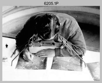
... overlapping aerial photographs using a pantograph arm with pencil onto... overlapping aerial photographs using a pantograph arm with pencil onto ...This is a set of six photographs of stereoscopic equipment and personnel at the Army Survey Regiment, Fortuna, Bendigo, c1950s to c1960s. The stereoscopes shown in photos .1P and .2P were used to stereoscopically view and interpret features in overlapping aerial photographs. The stereoscopic plotters shown in photos .3P and .4P were used to stereoscopically plot topographic detail from overlapping aerial photographs using a pantograph arm with pencil onto a controlled plotting sheet. The Ryker Model PL-3 Wernstedt-Mahan type stereoscopic plotter shown in photos .5P and .6P was used for precision contouring, planimetry and profiling. It was a comparatively simple stereoscopic mapping instrument designed to use ordinary contact prints of aerial photographs. It provides for plotting on a constant scale and approximate tilt correction but does not provide refinements such as correction for lens distortion. The plotter in Photo .6P does not have its pantograph arm attached. These plotters pre-date the Wild B9 and B8 stereo plotters introduced in the 1960s.This is a set of six photographs of stereoscopic equipment and personnel at the Army Survey Regiment, Fortuna, Bendigo, c1950s to c1960s. Black and white photos are on photographic paper and were scanned at 300 dpi. .1) - Photo, black & white, c1950s to c1960s, Universal Stereoscope, unidentified technician. .2) - Photo, black & white, c1950s to c1960s, Old Delft Scanning Stereoscopes, unidentified technicians. .3) - Photo, black & white, c1950s to c1960s, Unidentified stereoscopic plotters and technicians. .4) - Photo, black & white, c1950s to c1960s, Unidentified stereoscopic plotter, CPL Bill Shapcott. .5) and .6) - Photo, black & white, c1950s to c1960s, Ryker Model PL-3 stereoscopic plotter.Photo .4P is annotated on back - ‘Bill Shapcott (CPL)’royal australian survey corps, army svy regt, rasvy, army survey regiment, fortuna, asr, air survey, photogrammetry -
Tatura Irrigation & Wartime Camps Museum
Photograph, Aerial View of Tatura
... Original coloured aerial photographs taken over Tatura... Tatura the-murray Original coloured aerial photographs taken over ...Original coloured aerial photographs taken over Tatura. Landmarks include football and cricket ovals, Lake Bartlett, primary school, swimming pool, tennis courts, caravan park, O'Reilly Road, Hastie Road and Maher Road.Coloured photograph of Tatura from the air.on back: Summer January 1987 from Keith Albrect -
 National Vietnam Veterans Museum (NVVM)
Photograph, Photograph Collage, Vietnam Collection
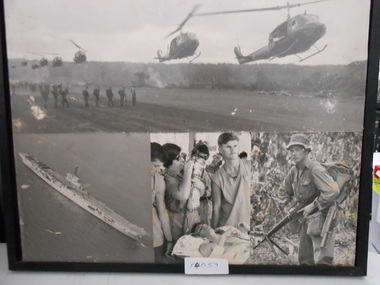
... Photograph Collage of four black and white Photograph. 1... landing for Troop Extraction. 2. Aerial photograph of Aircraft ...Photograph Collage of four black and white Photograph. 1. Eight Huey Helicopters landing for Troop Extraction. 2. Aerial photograph of Aircraft Carrier 3. Injured Soldier in Field Hospital. 4. Soldier in Jungle greens with M16photograph, huey helicopter, m16 assult rifle, aircraft carrier -
Clunes Museum
Map, Surface Geology Plan
... Photocopy of Plan Block 19/19 Scale 1 inch = 100 feet .3 AERIAL... Scale 1 inch = 100 feet .3 AERIAL PHOTOGRAPH WITH WORKINGS ...Plans show various shaft locations.1 Photocopy of Plan Block 23/19 Scale 1 inch = 100 feet .2 Photocopy of Plan Block 19/19 Scale 1 inch = 100 feet .3 AERIAL PHOTOGRAPH WITH WORKINGS MARKED - LAMINATED.1 C-21 North Broken Hill Ltd Clunes Block 23/19 .2SOUTH CLUNES MINE Ltd Clunes Block 19/19north broken hill ltd, surface geology plan -
City of Kingston
Photograph - Black and white, 27 February 1964
... Aerial photograph of the suburbs of Cheltenham and Highett... handwritten: X 166 Aerial photograph of the suburbs of Cheltenham ...Cheltenham is a suburb in the City of Kingston that was originally established as a rural market gardening community. The area is bordered by Highett. The previous market gardens, farms and paddocks have gradually been sub-divided into housing and industrial estates. The Methodist Children's Home Methodist Homes for Children and St John of God Training Centre on the site of the future Southland shopping centre has not yet been demolished. The recently built Cheltenham High School is visible and the increased urbansation of the area is evident. Some farmland remains including the Le Page homestead.The developing urban area of Cheltenham within the City of Kingston. This image illustrates the mid-century urban sprawl of of Cheltenham and the subdivision of market gardens within the municipality and the changing demographic of the district as new houses are constructed and infrastructure established.Aerial photograph of the suburbs of Cheltenham and Highett within the City of Kingston. Highett Gas Works (top left); Bernard Street, Cheltenham (top right); Weatherall Road (bottom left): Elliott and Cobham Streets Cheltenham (bottom right).White handwritten: X Vic.1831 White type: MELBOURNE 1963 PROJECT RUN23 [underlined] 27-2-64 LENS 205 152-70 M/M 5.150 [arrow] White handwritten: X 166 cheltenham, highett, urbanisation -
 Greensborough Historical Society
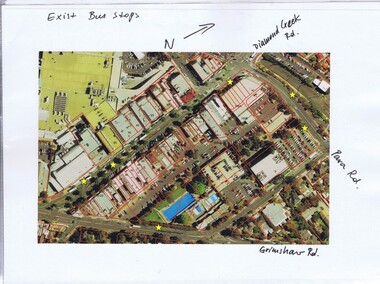
Folder, Banyule City Council, Main Street Greensborough, 2007-2011
... , plus one aerial photograph of the area bounded by Grimshaw... of Main Street Greensborough, plus one aerial photograph ...Folder of coloured photographs of Main Street Greensborough, plus one aerial photograph of the area bounded by Grimshaw, Flintoff, Para and Main Streets and one of Grimshaw Street between Henry and Main Streets. Greensborough Shopping Centre prior to the construction of WatermarcGreen plastic folder of coloured photographic prints of Main Street Greensborough.main street greensborough, banyule city council, watermarc -
 Greensborough Historical Society
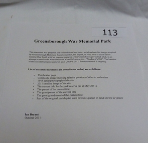
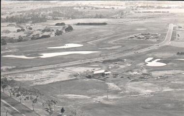
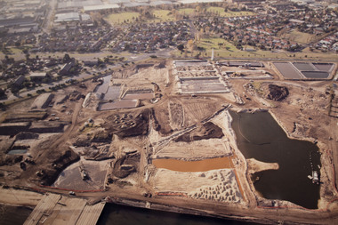
Work on paper - Folder of Documents, Ian Bryant, War Memorial Park Greensborough, 2011_
... including aerial photographs and title documents (collected by Ian... including aerial photographs and title documents (collected by Ian ...Folder of documents about War Memorial Park Greensborough including aerial photographs and title documents (collected by Ian Bryant) and other information on War Memorial Park bordered by McDowell Street, Ester Street, Henry Street and Vermont Parade Greensborough.Folder of documents - 2 ring binder and A4 printed pages in plastic pockets.greensborough war memorial park, public space, war memorials, ian bryant, parks banyule -
 Hume City Civic Collection
Photograph
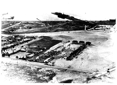
... A black and white aerial photograph of an aerial view... photograph of an aerial view of the newly established Goonawarra Golf ...A black and white aerial photograph of an aerial view of the newly established Goonawarra Golf Club. Sunbury Road is visible in the bottom LH corner and Francis Avenue crosses the photograph. The clubhouse is in the centre of the photograph and some early housing development is in the distance.goonawarra gold club, housing developments, regional newspaper, george evans collection -
 Department of Energy, Environment and Climate Action
Zeiss Sketchmaster
... from aerial photographs onto scale maps. The operator views... from aerial photographs onto scale maps. The operator views ...The Zeiss Sketchmaster was used to transfer information from aerial photographs onto scale maps. The operator views the aerial photograph and the map simultaneously and manually traces detail from the photograph onto the map. It utilises the principle of the camera lucida, patented in 1806. Various lens combinations were used on a to adjust for scale and then “rubber sheet” the image to line up topographic features like streams and roads. The photo information was then laboriously transferred using a light table onto large A0 paper maps or translucent drafting film. The maps were later hand coloured with either Derwent pencils or delicately painted with Pelikan ink wash. This item is kept at Erica.Zeiss Sketchmaster. c1970s. Includes adjustable stand, various lens in sperate box, adjustable light, map holder and magnetsforests commission victoria (fcv), forest measurement, mapping, surveying -
 Port Melbourne Historical & Preservation Society
Photograph - Aerial view Beacon Cove area during soil cleaning operation, 1990
... Framed colour aerial photograph of the Beacon Cove area... Environmental Issues Framed colour aerial photograph of the Beacon Cove ...Framed colour aerial photograph of the Beacon Cove area during the soil cleaning operation prior to building the project. Area covered: from Beacon Road to Bain Street, and from the beach to the rear beacon. Foot of Princes Pier also shown.environmental issues -
 Ballarat Tramway Museum
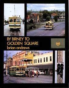
Book, Brian Andrews, "By Birney to Golden Square", 1973
... , notes on the rolling stock with an aerial photograph of Bendigo... and colour photographs, including tickets, photos along each route ...Features both black and white and colour photographs, including tickets, photos along each route, Charing Cross, depot, notes on the rolling stock with an aerial photograph of Bendigo with the tram routes marked in and a fold out detailed map of Bendigo and its track layout.Yields information about the Bendigo tramways operated by the SEC in a photographic and text format.Book, 78 pages including card cover, printed on gloss paper, titled "By Birney to Golden Square", written by Brian Andrews, published by Southern Cross Traction, Kensington Park SA. Sub-titled "The last last years of Bendigo's tramways", 1973. trams, tramways, bendigo, sec tramways, maps -
Tatura Irrigation & Wartime Camps Museum
Photograph - copy, copy 1990
... Black and white photograph. Aerial photo 1946... tatura internment camps Black and white photograph. Aerial photo ...WW2 internment camp 1, Tatura. Black and white photograph. Aerial photo 1946internment camps, tatura internment camps -
 Lakes Entrance Historical Society
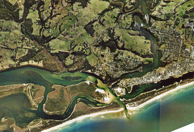
Photograph - Topography, 2007c
... Colour aerial photograph of the land forms around...Waterways Navigation Topography Colour aerial photograph ...Colour aerial photograph of the land forms around the entrance to the Gippsland Lakes, from Kalimna West to Lakes Entrance, North Arm to the ocean. Shows massive sand buildup between Rigby Island and Kalimna, also Bullock Island. Lakes Entrance Victoriawaterways, navigation, topography -
 Lakes Entrance Historical Society
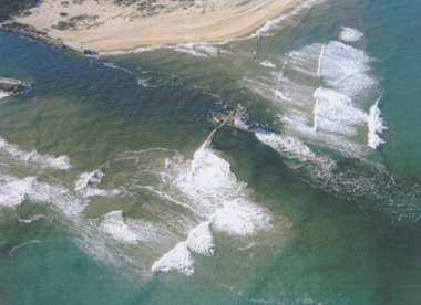
Photograph - Boat Harbour, Gippsland Ports, dredge April Hamer Lakes Entrance, 2006
... Colour aerial photograph of the Entrance from Bass Strait...Waterways Topography Beaches Ocean Colour aerial photograph ...Colour aerial photograph of the Entrance from Bass Strait to the Gippsland Lakes showing rock entrance groynes, surf on beach, dredge April Hamer working in the channel Lakes Entrance Victoria. Also another copy size 15 x 19.5 cmwaterways, topography, beaches, ocean -
 Port Melbourne Historical & Preservation Society
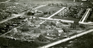
Photograph - Aerial view of houses during construction on Dunstan Estate, Port Melbourne, Department of Public Works, 1936
... . Griffin Crescent and Southward Avenue .04 - Aerial photographs... and Southward Avenue .04 - Aerial photographs (also shows Graham St ...Twenty five (25) black and white or sepia photographs of the houses of the Dunstan Estate during their construction i.e. Griffin Crescent and Southward Avenue .04 - Aerial photographs (also shows Graham St School) Taken in 1936, some cars shown parked in streetsbuilt environment - domestic, domestic life, department of public works, dunstan estate, percy e everett, henry pye, albert dunstan -
 Ringwood and District Historical Society
Photograph, Composite Aerial Views of Ringwood, Victoria - 1972
... Two composite black & white aerial photographs with north.... Two composite black & white aerial photographs with north ...Two composite black & white aerial photographs with north-facing view over Maroondah Highway, including Railway Station precinct, Civic Centre precinct, Eastland, Mount Dandenong Road, Bedford Road, Ringwood Street, Warrandyte Road, Mullum Road, Loughnan's Road.Department of Crown Lands and Survey. Maroondah Highway Project - Run 3 - 20.1.72 - 3,900' ASL. -
 Ringwood and District Historical Society
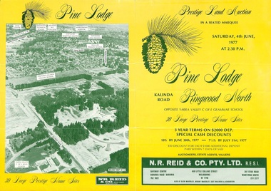
Flyer, Land Auction Sale Brochure, Pine Lodge, Ringwood North, Victoria - 1977
... print showing aerial photograph and map of subdivision layout... print showing aerial photograph and map of subdivision layout ...Refer also to Reg. No. 5172 for Pine Lodge Land Auction 3rd release, 1978.Yellow double-sided real estate auction notice with green print showing aerial photograph and map of subdivision layout and summary of local features and services for Pine Lodge, Kalinda Road, Ringwood North. Auction date, Saturday, 4th June, 1977, at 2:30pm.Subdivision plan includes Parkgate Drive, Wood-Church Close, and Pensby Court. (Agent) N.R. Reid & Co. Pty. Ltd., Safeway Centre, Boronia Road, Boronia (Phone) 762 1022, 450 Little Collins Street, Melbourne (Phone) 67 1746, and 207 Stud Road, Wantirna South (Phone) 231 2277. -
 Lakes Entrance Historical Society
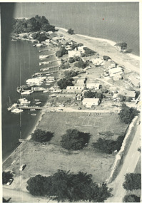
Photograph, Shaving Point Metung Victoria, 1960
... Black and white aerial photograph of village of Metung...Waterways Black and white aerial photograph of village ...Black and white aerial photograph of village of Metung showing hotel and main wharf and private jetties on Bay side, and beach on Lake King side with road to Shaving Point Metung Victoria. Also a black and white photograph of Village Store Metung Victoria 1930 cwaterways -
 Port Melbourne Historical & Preservation Society
Photograph - Aerial view of first Bank Houses in Garden City, 1927
... Photographic copies from black and white aerial photograph... and white aerial photograph of the building of the first State ...Photographic copies from black and white aerial photograph of the building of the first State Savings Bank Houses in Garden City 1927, showing also Graham Street State School, Princes Pier, Graham Street and Williamstown Road, west wing of Station Pier ("Rotomahana" at pier)built environment - domestic, fishermans bend, garden city, education - primary schools, melbourne harbor trust - port of melbourne authority, state savings bank of victoria, graham street state school, port melbourne primary school, bank houses -
 Bendigo Historical Society Inc.
Photograph - HANRO COLLECTION: AERIAL VIEW OF HANRO BENDIGO
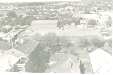
... Photograph. Black and White aerial view photograph... and White aerial view photograph of the Hanro Knitting Mills ...Photograph. Black and White aerial view photograph of the Hanro Knitting Mills, Hargreaves Street, Bendigo, in the centre of the photo.organization, business, hanro knitting mills, hanro -
 Orbost & District Historical Society
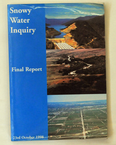
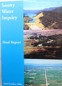
book, Snowy Water Inquiry, Snowy Water Inquiry Final Report, 1998
... cover are three aerial photographs of the Snowy River and Snowy... cover are three aerial photographs of the Snowy River and Snowy ...The Snowy Water Inquiry was commissioned in 1998 with a brief to recommend environmental water release options to the Commonwealth, Victorian, and NSW Governments so that corporatisation of the Snowy Mountains Scheme could proceed. These release options related to the Snowy River below Jindabyne, the Murray River and other rivers associated with the Scheme. The Inquiry objectives were that the recommendations would not adversely impact on water supplies to existing irrigators or the viability of the Snowy Mountains Scheme. (ref snowyhydro.com.au)This report contains information about water allocation and uses of the Snowy River.A book of 160 pp - Snowy River Inquiry Final report 23rd October 1998. Submitted to the Governments of New South Wales and Victoria / Commissioner: The Hon. Robert Webster. On the front cover are three aerial photographs of the Snowy River and Snowy Hydro Scheme. The book contains maps and photographs. snowy-river snowy-hydro snowy-mountains government-inquiry -
 Federation University Historical Collection
Photograph - Photograph - Colour, Aerial Views of Sites Relating to the University of Ballarat, c1998
... Five colour aerial photographs of sites associated... ballarat aerial view ballarat school of mines aerial aerial brewery ...The Ballarat Technology Park is associated with Federation University Australia. Five colour aerial photographs of sites associated with Federation University Australia. .1 & .2) Aerial views of the State Data Centre, Ballarat Technology Park .3) Aerial view of Mt Helen Campus, c1990 .4 and .5) Aerial View of Ballarat School of Mines Campus, 1998ballarat technology park, state region data centre, ballarat aerial view, ballarat school of mines aerial, aerial, brewery building, ballarat uniting church, albert street -
 Ballarat Tramway Museum
Document - Photocopies, John Phillips, Bungaree Aerial photo, 1980's
... Two sets of three copies of the Victorian Railways aerial... at Seymour St loop. Trams tramways Bungaree Aerial views Victorian ...Demonstrates the use of bogie trams on the Lydiard St North route and the crossing of trams at Seymour St loop.Two sets of three copies of the Victorian Railways aerial photographs of Bungaree Railway station late 1960's early 1970's. Shows tennis court, station buildings, houses and sheds in the station yard. The level crossing does not appear to have any flashing lights installed on it.trams, tramways, bungaree, aerial views, victorian railways -
 Wodonga & District Historical Society Inc
Book - Snowy Water Inquiry Final Report 23rd October 1998, Robert Webster et al, 1998
... cover are three aerial photographs of the Snowy River and Snowy.... Robert Webster. On the front cover are three aerial photographs ...The Snowy Water Inquiry was commissioned in 1998 with a brief to recommend environmental water release options to the Commonwealth, Victorian, and NSW Governments so that corporatisation of the Snowy Mountains Scheme could proceed. This book contains the findings of the Inquiry into water allocation and uses of the Snowy River.A book of 160 pp - Snowy River Inquiry Final report 23rd October 1998. Submitted to the Governments of New South Wales and Victoria / Commissioner: The Hon. Robert Webster. On the front cover are three aerial photographs of the Snowy River and Snowy Hydro Scheme. The book contains maps and photographs.non-fictionThe Snowy Water Inquiry was commissioned in 1998 with a brief to recommend environmental water release options to the Commonwealth, Victorian, and NSW Governments so that corporatisation of the Snowy Mountains Scheme could proceed. This book contains the findings of the Inquiry into water allocation and uses of the Snowy River.snowy river hydro, snowy river government inquiry, water allocations, water resources developmen -
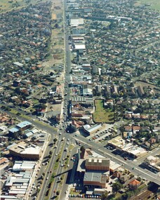 City of Kingston
Photograph - Colour, c. 1982
... This aerial photograph of South Road and Nepean Highway...Colour photograph of an aerial view of South Road... Parkdale This aerial photograph of South Road and Nepean Highway ...This aerial photograph of South Road and Nepean Highway, Moorabbin shows the area where houses and shops on the south side of the Nepean Highway have demolished for the widening of the highway. The pressures of rapid urban development in Moorabbin and beyond, especially to the south of Moorabbin caused bottlenecks and delays, especially at the South Road and Nepean Highway intersection, hence the scheme to widen Nepean Highway.The pressures of rapid urban development in terms of people, housing construction, industrial development and commercial activity, in Moorabbin and beyond, especially to the south would put pressure on road infrastructure in the region. In the early 1980s, a major road expansion of the Nepean Highway was implemented to increase capacity on this major thoroughfare for vehicle commuters. Car use had also increased with commuters from the increasingly populous southern suburbs travelling to their place of work in the Melbourne CBD.Colour photograph of an aerial view of South Road and Nepean Highway, Moorabbin. The image shows houses on the south side of the Nepean Highway that have demolished for widening of road. It features housing and commercial buildings looking north towards Cummins Road.Handwritten blue ink: 82 - 5452 - 11 Handwritten red ink: 112% Handwritten black ink: Ch. 7nepean highway, south road, moorabbin, roads, transport, infrastructure