Showing 1425 items matching "allotment"
-
 Ringwood and District Historical Society
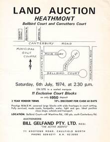
Flyer - Land Auction, Carruthers Estate, Heathmont, Victoria - 1974
Double-sided page advertising auction of 11 allotments on Saturday, 6th July, 1974, with locality map and plan of subdivision in Carruthers Court and Bellbird Court, Heathmont. $950 deposit, 3 year vendor terms, 10% discount for cash 60 days. Handwritten notation indicating Lot 22 "sold for $127,000 - all other lots passed in around $11,000".Auctioneers - Bill Gelfand Pty. Ltd., R.E.S.I. 71 Kooyong Road, Caulfield North, Phone 5090211 A.H. 523050. -
 Bendigo Historical Society Inc.
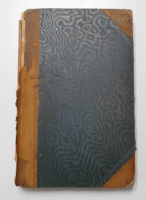
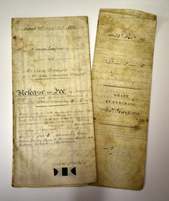
Document - LANDS OFFICE: SALE OF CROWN LANDS BY PUBLIC AUCTION, 25/5/1898 - 26/8/1915
Journal: green hard cover journal with brown spine and corners. LH page: lot, county, town or parish, section, allotment, extent, why not sold, upset price per acre, sold for per acre. RH page: value of improvements, name of purchaser, residence, deposit forfeited, total amount. Contains details of sales by public auction across Victoria.Lands Officecrown lands public auction, lands office, crown lands, public auction., sandhurst -
 Bendigo Historical Society Inc.
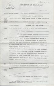
Document - H. A. & S. R. WILKINSON COLLECTION: CONTRACT OF SALE
Contract of sale of land dated 12th August, 1954 between Mr. D. G. & Mrs. E. Sumbler (vendor) and Mrs. H. Sutherland (purchaser). Property: land being part of Crown allotment 150 section M at Eaglehawk, Parish of Sandhurst, City of Bendigo, land described in certificate of title volume 5922 folio 213 and situate corner Wallen and Stone Streets, California Gully. Also all that piece of land being part of Crown allotment 150 section M at Eaglehawk, Parish of Sandhurst City of Bendigo, land described in certificate of title volume 1092 folio 240 and adjoining the above mentioned land situate corner Stone and eagle Streets, California Gully, together with 5 roomed weatherboard dwelling, all sundry outbuildings and all linos. Price: 1,680 pounds.organization, business, h.a. & s.r wilkinson real estate -
 Bendigo Historical Society Inc.
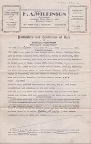
Document - H. A. & S. R. WILKINSON COLLECTION: CONTRACT OF SALE
Conditions of sale by private contract dated 19th July, 1950 between R. C. Orde (vendor) and H. J. & M. E. Stephenson (purchaser). Property: all that piece of land situate in Havlin Street, Bendigo being part of Crown allotment 326A section H, Parish of Sandhurst City of Bendigo, land described in certificate of title volume 5965 folio 1192804. Also all that piece of land situate in Havlin street adjoining the above mentioned land being allotment 326C section H land described in crown Grant volume 6018 folio 1293456, together with 5 room weatherboard dwelling and all sundry outbuildings, all fly wire doors, window screens, electric light globes and shades, with exception of the shade and chains in the front bedroom. Price: 2,585 pounds.organization, business, h.a. & s.r wilkinson real estate -
 Kew Historical Society Inc
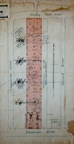
Plan - Subdivision Plan, Thornton Estate, 1918
The ‘Thornton Estate’ was the final subdivision of ‘Thornton’ in Studley Park Road. Thomas Cubitt Balmain originally owned Thornton, next to John Carson’s ‘Clutha’. Before its final subdivision, the Thomson family owned it. The Estate was a subdivision of 15 residential allotments running between Studley Park Road and Stevenson Street. The allotments faced these streets as well as Thornton Street, which the vendor undertook to make. Contemporary newspaper advertisements advised that ‘The estate possesses many advantages, notably its private and secluded, though convenient, position, splendid frontages and depths, and being close to the electric tram and Kew train, also within easy walking distance of the Victoria-street cable tram’. The terms offered purchasers were ten per cent deposit, with the balance to be paid in ten equal half-yearly payments at a rate of 5 per cent.subdivsion plans - kew, studley park, thornton estate -
 Kew Historical Society Inc
Plan - Subdivision Plan, J R Mathers & McMillan, Glenarbor Estate, 1934
Pru Sanderson, in her groundbreaking ‘City of Kew Urban Conservation Study : Volume 2 - Development History’ (1988), summarised the periods of urban development and subdivisions of land in Kew. The periods that she identified included 1845-1880, 1880-1893, 1893-1921, 1921-1933, 1933-1943, and Post-War Development. These periods were selected as they represented periods of rapid growth or decline in urban development. An obvious starting point for Sanderson’s groupings involved population growth and the associated economic cycles. These cycles also highlighted urban expansion onto land that was predominantly rural, although in other cases it represented the decline and breakup of large estates. A number of the plans in the Kew Historical Society’s collection can also be found in other collections, such as those of the State Library of Victoria and the Boroondara Library Service. A number are however unique to the collection.The Kew Historical Society collection includes almost 100 subdivision plans pertaining to suburbs of the City of Melbourne. Most of these are of Kew, Kew East or Studley Park, although a smaller number are plans of Camberwell, Deepdene, Balwyn and Hawthorn. It is believed that the majority of the plans were gifted to the Society by persons connected with the real estate firm - J. R. Mathers and McMillan, 136 Cotham Road, Kew. The Plans in the collection are rarely in pristine form, being working plans on which the agent would write notes and record lots sold and the prices of these. The subdivision plans are historically significant examples of the growth of urban Melbourne from the beginning of the 20th Century up until the 1980s. A number of the plans are double-sided and often include a photograph on the reverse. A number of the latter are by noted photographers such as J.E. Barnes.The little-known Glenarbor Estate comprised 23 allotments bordering Wellington and Denmark Streets and Fenton Avenue. The auction of the allotments in the Estate was held in the Kew Recreation Hall. The purported advantages to Kew are identified on the plan, such as the close proximity of the entrance to the Kew Railway Station and access to shops in Denmark Street. Due to its location, the subdivision was pitched at commercial as well as residential purchasers. The Estate was to cause a crisis in the Kew Council as a majority of councillors voted on 29 May to acquire the entire Estate as the location of a new Town Hall. The Estate was said to be valued at £50,000. A later meeting was to rescind the vote, instead opting for the compulsory acquisition of South Esk on the corner of Charles Street and Cotham Road. That acquisition was to be overturned by the State Government. The debate about the purchase of the Glenarbor Estate by Council coincided with the decision to widen High Street on the South side between Cotham Road and the Junction."D"subdivision plans - kew, glenarbor estate, wellington street, denmark street -
 The Beechworth Burke Museum Research Collection
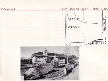
Card (Series) - Index Card, George Tibbits, Cnr Kars & Last Streets, Beechworth, 1976
George Tibbits, University of Melbourne. Faculty of Architecture, Building and Town & Regional PlanningIndex system that support the research for Beechworth : historical reconstruction / [by] George Tibbits ... [et al]Arranged by street names of BeechworthEach index card includes: street name and number of property, image of property, allotment and section number, property owners and dates of ownership, description of the property according to rate records, property floor plan with dimensions.beechworth, george tibbitsbeechworth, george tibbits -
 The Beechworth Burke Museum Research Collection
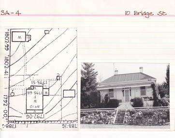
Card (Series) - Index Card, George Tibbits, 10 Bridge Street, Beechworth, 1976
George Tibbits, University of Melbourne. Faculty of Architecture, Building and Town & Regional PlanningIndex system that support the research for Beechworth : historical reconstruction / [by] George Tibbits ... [et al]Arranged by street names of BeechworthEach index card includes: street name and number of property, image of property, allotment and section number, property owners and dates of ownership, description of the property according to rate records, property floor plan with dimensions.beechworth, george tibbitsbeechworth, george tibbits -
 The Beechworth Burke Museum Research Collection
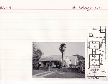
Card (Series) - Index Card, George Tibbits, 18 Bridge Street, Beechworth, 1976
George Tibbits, University of Melbourne. Faculty of Architecture, Building and Town & Regional PlanningIndex system that support the research for Beechworth : historical reconstruction / [by] George Tibbits ... [et al]Arranged by street names of BeechworthEach index card includes: street name and number of property, image of property, allotment and section number, property owners and dates of ownership, description of the property according to rate records, property floor plan with dimensions.beechworth, george tibbitsbeechworth, george tibbits -
 Warrnambool and District Historical Society Inc.
Document, Wollaston sale, 1919
This is a poster advertising the sale of part of the Wollaston Estate in Warrnambool in 1919. The sections for sale were Allotments 1, 18 and 19 which included the Wollaston Homestead. The original Wollaston property of 679 acres was selected by Thomas Manifold in the late 1840s. This land, on the northern side of the Merri River, near the Woodford Road was three kilometres from the Warrnambool town. The first farmer we know who leased the property was William Simpson. Walter Manifold inherited the property and he took it over in 1884. The swing bridge he built in 1890 still stands today. In 1919 the Closer Settlement Board of Victoria acquired Wollaston and 17 lots were sold to returned soldiers for farming purposes. By 1930 there were only five soldier settlers remaining. In 2009 further subdivision took place with lots sold for residential purposes. The homestead allotments were sold separately in 1919 with various owners of the homestead itself recorded since that time. This poster is of interest as it shows the areas of the Wollaston Estate which were sold in 1919. The history of this estate is well-documented and of importance in the history of Warrnambool. This is a sheet of paper with red and black printing and a map of the Wollaston Estate which is photo-lithographed. The sheet has been folded three times. It has some small tears at the top of the page. wollaston, history of warrnambool, walter manifold -
 Warrnambool and District Historical Society Inc.
Legal record - Two documents regarding purchase and sale of land, George Barber, Port Fairy solicitor, early 1850s
Thes two documents deal with the purchase and sale of land near Warrnambool by Thomas Simpson. The first document, called a Grant by Purchase, is dated 1852 and shows that Thomas Simpson purchased from the Crown, Allotment 146 (22 acres two roods) adjoining the property of Wollaston on the Merri River and the Mortlake Road, north of Warrnambool. The cost was 90 pounds. The second document is dated 1853 and shows that Thomas Simpson sold this Merri River allotment of 22 acres to Eliza Bromfield, in conjunction with her husband, John Davenport Bromfield, for the sum of 110 pounds. The property of Wollaston was owned by the Manifold family and in the 1850s was leased to William Simpson, the brother of Thomas who had an adjoining property called Wooramoota. John Davenport Bromfield was a Colac farmer who played a prominent part in the early history of that town. His brother James Astley Bromfield, an early chemist in Warrnambool is important in Warrnambool's history.These two items are of considerable significance because they are amongst the earliest legal documents we have connected to Warrnambool's history and because they concern three early pioneers of the district. They also have a connection to Wollaston, an important early property in the Warrnambool district..1 A piece of light parchment paper, stained with age and folded in three places. It contains printed and handwritten material, a copy of a signature and a white seal. .2 A piece of parchment paper folded in half and then folded again in two places. It contains ruled red lines, handwritten material in black ink and the remains of a red seal. The top of the first page has a cut-out fluted pattern.wollaston, john davenport bromfield, thomas simpson, eliza bromfield, george barber solicitor -
 Warrnambool and District Historical Society Inc.
Map, Department of Lands and Survey (Lithographers), Caramut township, 1938
This map of the township of Caramut was produced in 1938 but shows the original land owners of each town allotment and of the surrounding area. The size of all the allotments and the date of the original purchase are also shown. Caramut is a Victorian Western District town on Mustons Creek on the Hamilton Highway 48 kilometres from Warrnambool. This map was used by Rolf Crawley when he was the engineer for the Shire of Warrnambool from 1935 to 1968. The annotations on the map have probably been made by Rolf Crawley as they refer to the records and letter books of his father, John William Crawley, Junior (Shire of Warrnambool Engineer 1895 to 1935). Both Rolf Crawley and his father, John had private businesses as architects, surveyors and engineers and the map could have been used in connection with both their official Shire duties and their private businesses. The last owner of the map was the surveyor, Michael Hand who took over the business of Rolf Crawley in the late 1960s. This map is of great interest firstly because it has all the historical details of the land first purchased in the town of Caramut and area and secondly because it came from the office of Rolf Crawley, the engineer for the Shire of Warrnambool from 1935 to 1968. This is a buff-coloured paper map with a cloth backing. The map details are in black and white print. There are some handwritten red and black annotations on the map. “Town of Caramut Parish of Caramut County of Villiers’town of caramut, john william crawley junior, warrnambool, rolf crawley, warrnambool -
 Bendigo Historical Society Inc.
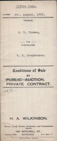
Document - H.A. & S.R. WILKINSON COLLECTION: CONTRACT OF SALE
Conditions of sale by private contract dated 5th August, 1935 between E.T. Thomas (seller) and W.H. Stephenson (buyer) for land situate in Shipp Street, Bendigo being part of Crown allotment 308 section H, having a frontage of 66 feet to Shipp street by a depth of 155 feet 1 inch, being the south-western half of the said block. Price 135 pounds.organization, business, h.a. & s.r wilkinson real estate -
 Bendigo Historical Society Inc.
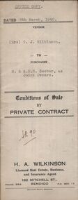
Document - H.A. & S.R. WILKINSON COLLECTION: CONTRACT OF SALE
Conditions of sale by private contract dated 8th March, 1940 between Mrs. G.J. Wilkinson (seller) and R. and A.M.B. Seeber (buyers) for land situate Panton Street, Golden Square, being Crown allotment 1 section 6A land described in certificate of title volume 3571 folio 750198, together with 5-roomed weatherboard dwelling and all sundry. Price 350 pounds.organization, business, h.a. & s.r wilkinson real estate -
 Bendigo Historical Society Inc.
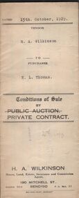
Document - H.A. & S.R. WILKINSON COLLECTION: CONTRACT OF SALE
Conditions of sale by private contract dated 15th October, 1929 between R.A. Wilkinson (seller) and E.L. Thomas for freehold land situate 18 McClure Street, Ironbark being Crown allotment 497 section K described in Crown grant volume 2471 folio 494141, together with 5-roomed stone, wood and brick dwelling and all sundry. Price 270 pounds.organization, business, h.a. & s.r wilkinson real estate -
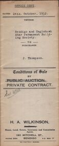 Bendigo Historical Society Inc.
Document - H.A. & S.R. WILKINSON COLLECTION: CONTRACT OF SALE
Conditions of sale by private contract dated 24th October, 1932 between Bendigo and Eaglehawk Star Permanent Building Society (seller) and J. Thompson (buyer) for land situate Lily Street, Bendigo being Crown allotment 1B section 14B described in Crown grant volume 258 folio 51486, together with all dwellings and erections on the said land. Price 315 pounds.organization, business, h.a. & s.r wilkinson real estate -
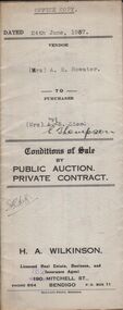 Bendigo Historical Society Inc.
Document - H.A. & S.R. WILKINSON COLLECTION: CONTRACT OF SALE
Conditions of sale by private contract dated 24th June, 1937 between Mrs. A.E. Bowater (seller) and Mrs. E. Thompson (buyer) for land situate 55 Shamrock Street, Bendigo being Crown allotment 2 section 21B described in certificate of title volume 3308 folio 661460, together with 6-roomed weatherboard dwelling and all sundry. Price 530 pounds.organization, business, h.a. & s.r wilkinson real estate -
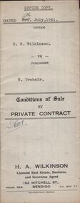 Bendigo Historical Society Inc.
Document - H.A. & S.R. WILKINSON COLLECTION: CONDITION OF SALE
Conditions of sale by private contract dated 5th July, 1941 between S. R. Wilkinson (seller) and W. Trahair (buyer) for land situate No. 6 Hayes Street, Bendigo, being part of Crown allotment 510 section A described in certificate of title volume 1628 folio 1225600, together with 5-roomed weatherboard and rough cast dwelling and all sundry. Price 650 poundsorganization, business, h.a. & s.r wilkinson real estate -
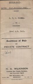 Bendigo Historical Society Inc.
Document - H.A. & S.R. WILKINSON COLLECTION: CONDITION OF SALE
Conditions of sale by private contract dated 21st November, 1941 between A.W.A. Morley (seller) and Mrs. A.B. Toll (buyer) for land situate corner Lilly and Creek Streets, Bendigo being part of Crown allotment 10 section 134C described in certificate of title volume 3043 folio 608435, together with 5-roomed weatherboard dwelling and all sundry. Price 475 pounds.organization, business, h.a. & s.r wilkinson real estate -
 Bendigo Historical Society Inc.
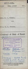
Document - H.A. & S.R. WILKINSON COLLECTION: CONTRACT OF SALE
Contract of sale of land dated 15th August, 1951 between Mrs. E.R. Tieman (seller) and Mr. H.A. Pitson (buyer) for land being part of Crown allotment 6 section 71C described in certificate of title volume 4173 folio 834590 situate No. 47 Station Street, Bendigo, together with 4-roomed weatherboard dwelling and all sundry. Price 1,720 pounds.organization, business, h.a. & s.r wilkinson real estate -
 Bendigo Historical Society Inc.
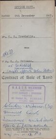
Document - H.A. & S.R. WILKINSON COLLECTION: CONDITION OF SALE
Contract of sale of land dated 9th December 1953 between Mr. C.S. Trewhella (seller) and Mr. S.J. Prineas (buyer) for land being part of Crown allotment 5 section 32 borough of Eaglehawk described in Certificate of title volume 7060 folio 912 and situate 1 Richards Street Eaglehawk, together with brick veneer dwelling and all sundry. Price 3,450 pounds.organization, business, h.a. & s.r wilkinson real estate -
 Bendigo Historical Society Inc.
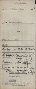
Document - H.A. & S.R. WILKINSON COLLECTION: CONDITION OF SALE
Contract of sale of land dated 10th June, 1954 between Mrs H. Edgecumbe (seller) and Mrs A.L. Pye (buyer) for land part of Crown allotment thirteen AB and twenty section K described in certificate of title volume 5223 folio 518, together with all buildings and erections thereon also all linos, blinds and electric fittings and shades. Price 1900 poundsorganization, business, h.a. & s.r wilkinson real estate -
 Bendigo Historical Society Inc.
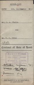
Document - H.A. & S.R. WILKINSON COLLECTION: CONDITION OF SALE
Contract of sale of land dated 6th September 1954 between Mr G.A. Fields (seller) and Mr. B.T. Owins (buyer) for land being part of allotment 7 section L, Long Gully colored red on the map hereof and being described in Indenture of Conveyance No.422 Book 610 and situate in Inglewood Street Bendigo, together with fencing thereon. Price 130 pounds.organization, business, h.a. & s.r wilkinson real estate -
 Bendigo Historical Society Inc.
Document - H.A. & S.R. WILKINSON COLLECTION: CONDITION OF SALE
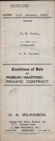
Conditions of sale by private contract dated 11th January, 1939 between F.W. Veale (seller) and G.W. Raines (buyer) for land situate No. 11 Alley Street, Bendigo being part of Crown allotment 70 section A at Ironbark Gully described in deed of conveyance, registered memorial 836 book 532, together with 4-roomed weatherboard dwelling and all sundry. Price 250 poundsorganization, business, h.a. & s.r wilkinson real estate -
 Bendigo Historical Society Inc.
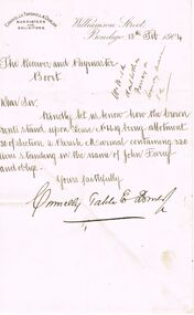
Document - CONNELLY, TATCHELL, DUNLOP COLLECTION: DOCUMENT
Letter from Conelly, Tatchell & Dunlop to The Receiver and Paymaster, Boort, dated 13 Feb 1904 re rents on Lease No 6619 Allotment 30 Section 2 Parish Marmal containing 320 acres in the name of John Furey. Written on the back, dated 15-2-04 ,are particulars of payments and the number of payments required to complete purchase. Signed J. Justin, Acting pm, Boort.business, legal, connelly & tatchell, connelly & tatchell collection - document, conelly tatchell & dunlop, john furey, j justins -
 Whitehorse Historical Society Inc.
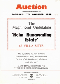
Document, Helm Nunawading Estate, 1957
Brochure advertising auction of 63 villa sitesBrochure advertising auction of 63 villa sites ' Helm Nunawading Estate', North East of Cnr Springvale Road and Springfield Road in Mitcham 17 November 1957. Auctioneers Wm. White & Sons, Frank Fisher & Co. Allotments sold for 400 pounds on high side of street, 350 pounds on lower side according to attached note by Bob Hirschfield in 1985. Includes plan of subdivision.Brochure advertising auction of 63 villa sites auctions, helm nunawading estate, olwen street, nunawading, efron street, springvale road, hirschfield, bob, william white and son, frank fisher & co. -
 Bendigo Historical Society Inc.
Legal record - Lands Act Application Register
Lands Act Applications Register. farms register for the South Riding of broad undefined extents. Handwritten entries in blue and black ink. Registering Name, Postal address, Parish, Allotment, Section, Area (acres, roods & perches). Dates noted across 17/07/1875 to 31/03/1876. Green lined and formatted legal register with leather/suede spine and cover corners. Handwritten entries in blue and black inkapplication register, farms, south riding -
 Bendigo Historical Society Inc.
Legal record - Ledger of Reports of Land Sales by Auction
Blue and light brown ledger of land sales reports during 1898 to 1924. Blue water marked cover with light brown spine and corners, with red label on spine noting "12". Contains Crown Lands sales by auction documents, including purchasers' names, land section, allotment numbers and price. Ledger of Land Sales Reports 1915 sample reports of Colbinabbin, Kyabram & Rochester.land sales, auction -
 Kew Historical Society Inc
Plan - Subdivision Plan, Cotham Vale Estate, 1919
Pru Sanderson, in her groundbreaking ‘City of Kew Urban Conservation Study : Volume 2 - Development History’ (1988), summarised the periods of urban development and subdivisions of land in Kew. The periods that she identified included 1845-1880, 1880-1893, 1893-1921, 1921-1933, 1933-1943, and Post-War Development. These periods were selected as they represented periods of rapid growth or decline in urban development. An obvious starting point for Sanderson’s groupings involved population growth and the associated economic cycles. These cycles also highlighted urban expansion onto land that was predominantly rural, although in other cases it represented the decline and breakup of large estates. A number of the plans in the Kew Historical Society’s collection can also be found in other collections, such as those of the State Library of Victoria and the Boroondara Library Service. A number are however unique to the collection.The Kew Historical Society collection includes almost 100 subdivision plans pertaining to suburbs of the City of Melbourne. Most of these are of Kew, Kew East or Studley Park, although a smaller number are plans of Camberwell, Deepdene, Balwyn and Hawthorn. It is believed that the majority of the plans were gifted to the Society by persons connected with the real estate firm - J. R. Mathers and McMillan, 136 Cotham Road, Kew. The Plans in the collection are rarely in pristine form, being working plans on which the agent would write notes and record lots sold and the prices of these. The subdivision plans are historically significant examples of the growth of urban Melbourne from the beginning of the 20th Century up until the 1980s. A number of the plans are double-sided and often include a photograph on the reverse. A number of the latter are by noted photographers such as J.E. Barnes.The Cotham Vale Estate was a subdivision of land between Alfred, Thomas, Rowland and John Streets. It was promoted in the same time as the nearby Normanby Heights Estate. Cotham Vale included 28 allotments. Contemporary newspaper advertisements noted that the Estate ‘is most conveniently situated in a well elevated position, only 2 minutes from Cotham rd. Electric Cars, penny section to Kew station’.subdivision plans - kew, cotham vale estate, rowland street -- kew (vic.), thomas street -- kew (vic.), john street -- kew (vic.) -
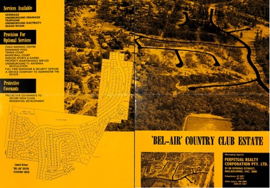 Ringwood and District Historical Society
Flyer, Land Sale Brochure, Bel-Air Country Club Estate, North Ringwood - circa 1978
Double sided A2 size yellow and black gloss print advertisement for residential subdivision, with progressive allotment price list notices. Subdivision includes Glenvale Road, Kubis Drive, June Square, Jenkins Close, Werac Drive, Manuela Terrace, Rudolf Court, Lyn Court, Burlock Avenue, Debbie Place, Pamela Place, Iluka Place, Chifley Parade, Menzies Crescent.Vendor and Managing Agents - McKuke Pty Ltd (Frank Kubis) and Perpetual Realty Corporation Pty. Ltd., 97-99 Spring Street, Melbourne, Vic. 3000. Telephone 63 4881, 63 3721, After hours 299 2085, (059) 84 1381.