Showing 742 items
matching land grant
-
 Ringwood and District Historical Society
Document, Certificate of Title - Alexander William Brown - part of Crown Section 20, Parish of Warrandyte, County of Evelyn - 16th April, 1948
A4 copies of Landata Victoria Historical Search documents - Vol 7141 Fol 1428080.Alexander William Brown of Grandview Grove (later Bemboka Road), Ringwood is now the proprietor of an Estate in Fee-simple subject to the Encumbrances notified hereunder ... 2 acres 3 roods 24 and one-half perches or thereabouts, being Lots 33 and 34 Kardinia Crescent, on Plan of Subdivision no.12040. Transfers include Alexander William Brown died 25th June, 1957, Probate granted 28th January, 1958, to Alfred Hart Brown of Dandenong, Estate Agent, and Harry Britten Elms of Cardinia, Gentleman, Oliver Burgess, Grandview Grove Ringwood, Florist - 14th May, 1964, Peter John Woodhead, Transport driver, and Shirley Margaret Woodhead, Married woman - 12th September, 1966. Inventory of Real Estate Assets (for Probate purposes 4/10/1957) detailed in Family Genealogy record for A.W. Brown includes: "Kardinia Crescent, Ringwood - Land containing 2 acres 3 roods 24-1/2 perches situate in Kardinia Crescent Ringwood being Lots 33 and 34 on Plan of Subdivision Number 12040 and being part of Crown Section 20 Parish of Warrandyte County of Evelyn and being the land described in Certificate of Title Volume 7141 Folio 080 valued by E. Miles at £350:0:0 -
 Ringwood and District Historical Society
Document, Certificate of Title - Leslie Mills of Plymouth Road, East Ringwood, Farmer - part of Crown Section 20, Parish of Warrandyte, County of Evelyn - 19th January, 1932
A4 copies of Landata Victoria Historical Search documents - Vol 5781 Fol 1156174.Leslie Mills is now the proprietor of an Estate in Fee-simple subject to the Encumbrances notified hereunder ... 10 acres or thereabouts, together with a right of carriage way over Grandview Grove (later Bemboka Road), Warranwood, Victroia. Transfers include Alexander William Brown of Tooradin, Farmer - 29th October, 1945, (died 25th June, 1957), Probate granted 28th January, 1958, to Alfred Hart Brown of Dandenong, Estate Agent, and Harry Britten Elms of Cardinia, Gentleman (*** See Probate details below) Oliver Burgess, Grandview Grove Ringwood, Florist - 14th May, 1964, Privatus Proprietary Limited, St.Kilda Road, Melbourne - 27th October, 1977, John Patrick Kelly, Company Director and Yvonne Gloria Kelly, Married Woman, joint proprietors, 10th September, 1980 *** Inventory of Real Estate Assets (for Probate purposes 4/10/1957) detailed in Family Genealogy record for A.W. Brown includes: "Grandview Grove, Ringwood Land containing 10 acres or thereabouts situate in Grandview Grove Ringwood being part of Crown Section 20 Parish of Warrandyte County of Evelyn and being the land described in Certificate of Title Volume 5781 Folio 174 on which is erected a 7 room house, a bungalow, shed and 2 glass houses valued by E. Miles, Ringwood - £5077-0-0 -
 Melbourne Tram Museum
Document - Personal Papers, Victorian Parliament, "Grant of certain Lands etc.", 1959
Act of Victorian Parliament, 8 pages, No. 6594 - "An Act to provide for the Grant of certain Lands to the After Care Hospital, the Melbourne District Nursing Service, the Victorian Civil Ambulance Service, St Georges Hospital, the Royal Talbot Colony for Epileptics, the Ballarat Orphanage and the Melbourne and Metropolitan Tramways Board respectively. Page 4 and 7 detail a block of land that the Board could have purchased for a major bus depot in Footscray Road for 60,175 pounds.trams, tramways, tramways, acts of parliament, mmtb, buses, depot, footscray rd, construction -
 Bacchus Marsh & District Historical Society
Map, Maddingley Township, Parish of Parwan, County of Grant, 1856
Maddingley is a locality or township within the broader township area of Bacchus Marsh. This map is dated 1856 but is based on an earlier survey in 1843. The main area of Maddingley shown on this map is an area bounded by Bacchus Street, Moore Street, Griffith Street and Franklin Street. Other streets visible are Inglis Street, Labilliere Street, McCrae Street. The area to the east of Franklin Street is not sub-divided and is described as an 'alluvial flat. A single page paper map showing land allotments, streets, and natural watercourses in the township of Maddingley. The map is pasted into a bound volume containing 76 maps or plans in total. Two inscriptions: 1. A.J. Skene Surveyor, 1843. ; 2. Surveyor-General's Office Melbourne, Sept 6, 1856. (Lithographed by R. Meikle)bacchus marsh victoria maps, maddingley victoria maps, land use, maddingley victoria history -
![Map, Millbank Estate Bacchus Marsh Thursday 4th October 1888 [Land sales], 1924](/media/collectors/5e461d8021ea67224c82f2a1/items/67765662eb6d2cbd24e0797f/item-media/67765682eb6d2cbd24e07a41/item-fit-380x285.jpg) Bacchus Marsh & District Historical Society
Bacchus Marsh & District Historical SocietyMap, Millbank Estate Bacchus Marsh Thursday 4th October 1888 [Land sales], 1924
... Grant Family Bacchus Marsh Millbank Estate Land Sales Single ...The Millbank Estate was a parcel of land close to the centre of the shopping area of Bacchus Marsh which was sub-divided and offered for sale in 62? lots on the 4th October 1888. The lots had frontages to Ballarat Road (Main Street), Maddingley Road (now Grant Street), Turner Street, Millbank Street, Clarinda Road (now Clarinda Street), and an unnamed street south of Turner Street (possibly known as Grant Street at this time) which connected to Maddingley Road through the vicinity of the present day Bacchus Marsh Hospital. This was a significant sub-division of land and represented a major expansion of residential housing in Bacchus Marsh in the late 19th century. The map includes a wealth of detail about the time of the sale, where it will take place, who the selling agents were, the deposit terms for purchases and details of a special train from Melbourne to Bacchus Marsh on sale day. The location of the allotments in relation to the shopping and commercial area of Bacchus Marsh, Maddingley and the railway station are indicated on an inset map within the overall map and poster. The Millbank Estate area was an area which had once belonged to the Grant family who were prominent early citizens of Bacchus Marsh and lived in a house in this area known as 'Millbank'.This land sale map is a typical example of housing estate land sales advertising maps produced by real estate agents in this era. The map is significant for the detailed information it provides about when and where land was sold for new housing estates in Bacchus Marsh in the late nineteenth century.Single page map showing land allotments for sale at auction in Bacchus Marsh in October 1888. A significant portion of the map is missing from the bottom right side. land sales bacchus marsh, land subdivsion bacchus marsh, housing estates land sales bacchus marsh, grant family bacchus marsh, millbank estate land sales -
 Bacchus Marsh & District Historical Society
Map, Mooradoranook Parish Map, County of Grant
... of Mooradanook in the County of Grant. Cadastral map showing land... in the County of Grant. Cadastral map showing land ownership. The map ...A single page paper map showing the map for the Parish of Mooradanook in the County of Grant. Cadastral map showing land ownership. The map is pasted into a bound volume containing 76 maps or plans in total. High resolution digital image stored on BMDHS computer network. Photo lithographed at the Department of Lands and Survey Melbourne by T. F. McGauran, 27.11.06mooradoranook parish maps, mooradoranook parish plan, bacchus marsh region parish plans -
 Bacchus Marsh & District Historical Society
Map, Mouyong Parish Map, County of Grant
... of Mouyong in the County of Grant. Cadastral map showing land... of Grant. Cadastral map showing land ownership. The map is pasted ...A single page paper map showing the map for the Parish of Mouyong in the County of Grant. Cadastral map showing land ownership. The map is pasted into a bound volume containing 76 maps or plans in total. High resolution digital image stored on BMDHS computer network. Photo lithographed at the Department of Lands and Survey Melbourne by T. F. McGauran, 9. 4. 07mouyong parish plan, mouyong parish maps, bacchus marsh region parish plans -
 Stawell Historical Society Inc
Photograph, Pleasant Creek Hospital 1866
Pleasant Creek Hospital. Part of a collection of Photographs by Mr. O.G. Armstrong as commissioned by the Shire of Stawell for the Inter-colonial and Paris Exhibition in Melbourne in 1866. Due to a public outcry for medical services on the goldfield a public meeting was held in the Olympic Theatre at Deep Lead on the 7th of August 1858. It appointed a 50 man committee to establish a hospital at Pleasant Creek. A temporary Tent structure was soon erected at Doctors Hill, situated midway between Deep Lead and Commercial Street Pleasant Creek, just South of the later Western Highway. The site is now marked by a commemorative stone. Within two months the committee had collected £600 in subscriptions, a government Grant for £2500 and acquired 10 acres of land. The foundation stone of the hospital building was laid on 21st December 1860 and the building completed and occupied by 21st June 1861. In the 1930’s the hospital moved to the centre of Stawell in Sloane Street and the buildings then taken over by the Pleasant Creek Training Centre. Brick hospital building with two ward wings and central front door. Man standing on steps.stawell health -
 Merri-bek City Council
Painting - Oil on linen, Renee Cosgrave, Learning Whakapapa (Māori Land Court Archives), 2023
-
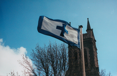 Ballarat Heritage Services
Photograph - Photograph - Colour, Flag of St Alipius', Ballarat East, 2004, 23/09/2004
"Centenary of Fnrst Mass at Ballarat Friday last marked the centenary of the arrival of the first priest and the celebration of the first Mass in Ballarat. The Rev. Patrick Dunne reached the diggings on October 17, and on Sunday, October 19, 1851, in a bark hut near Brown Hill, he celebrated Mass. Worshippers had to kneel on quartz gravel. The weather had been the worst experienced in Victoria for a number of years, and most of the creeks between Melbourne and Ballarat were flowing torrents, but Father Dunne (who came from the Coburg mission), carrying the barest necessities and the sacred vestments, set out for Ballarat on horseback. He had to ford and swim his horse across the creeks. When most of his congregation left for the Castlemaine diggings Father Dunne returned to Melbourne. In August, 1852, Rev. Matthew Downing became Ballarat's first resident priest. He built a large wooden structure with a canvas roof which served as a church, but later erected at the Gravel Pits the first permanent church. This church was the largest of any house of worship on any goldfield in the colony. It cost £ 100, contributed solely by Father Downing and his flock. Soon after he got the authorities to survey a large piece of land at the back of the township as a burial ground and procured a grant of £500 for fencing it. A grant of £250 was also obtained for the improvement of the chapel and fittings of a school, where Michael Campion Carey opened the first school. Rev. Patrick Smyth succeeded Father Downing, who was followed by Rev. P. Madden, who in 1857 began to plan the erection of St. Patrick's Church. The foundation stone of this was laid by Bishop Goold on February 12, 1858, and the church was opened for the first time on November 8, 1863." (Melbourne Advocate 25 October 1951)Two colour photographs showing the St Alipius' Catholic Church flag - a blue cross and border on white. st alipius, church, ballarat east, flag -
 Ringwood and District Historical Society
Document - Contract, Ringwood Property Sale from Thomas Grant to Walter and Philip Bamford 1908 (cnr Whitehorse Road and Warrandyte Road), 1908
The transfer of land in Ringwood from Thomas Grant to Walter and Philip Bamford on 21st March 1908.3 photocopied pages, poorly defined with some hand written details +Additional Keywords: Bamford, Walter / Bamford, Philip / Grant, Thomas -
 Geoffrey Kaye Museum of Anaesthetic History
Book, Longman, Brown, Green and Longmans, Physical Description of New South Wales and Van Diemen's Land. Accompanied by a geological map, sections, and diagrams, and figures of the organic remains, 1845
Dr. Gwen Wilson, Emeritus historian, gifted this book at ANZCA's first independent Annual Scientific Meeting held in Launceston in 1994. Dr Wilson presented this gift after her speech about the life of William Russ Pugh and his significant contribution to anaesthesia in Australia. It is unclear as to how the book came into Dr Wilson's possession. Published in London, 1845, for Longman, Brown, Green and Longmans, this book was formally owned by general practitioner Dr William Russ Pugh, being the first medical practitioner in Australia to administer ether anaesthetic on 7 June 1847, in Launceston. The author of the book, P E De Strzelecki acknowledges Pugh for his assistance during his stay in Launceston and for allowing him the use of his laboratory for the analysis of the soils and minerals that were subsequently reported in this book (Page 131). Tan coloured cloth book with an embossed circular motif on the centre of the front and back cover. The same embossed motif is repeated four times along the spine of the book. An embossed design of small, four petal flowers borders the edge of the front and back cover. The title of the book 'Strzelecki's New South Wales and Van Diemen's Land' is printed in gold on the spine. The cloth has come unstuck at various places around the spine and a small section is missing from the base of the spine. The cover is worn and has numerous dark stains possibly from mould. The book contains 19 engraved and lithographed plates. This includes a handcoloured octavo folding, geological map, bound as a frontispiece, depicting the NSW coast down to Gippsland and Tasmania, a fold out single colour geological cross section of the Newcastle Coal Basin, 14 plates illustrating shellfish and flora and three tinted lithographs. Single page maps at the back illustrate wind patterns around Australia. [front title page, two black ink stamps that have bled through to the next page] W R.PUGH [front title page, black ink, cursive writing] H Grant \ 5 May 1910 [front title page, pencil, cursive writing, written around Pugh's stamp] Purchased from \ (unrecognizable script) [front title page, previous owner's name was rubbed out and consequently tore the page making the entry unreadable] [Inner back cover, bottom LHS, blue stamp] BOUND BY \ WESTLEYS & \ CLARK \ LONDON [Inner front cover, bottom LHS, black and purple ink] P65 \ 76 \ 78 \ 98 \ 163 \ 164 \ 217strzelecki, van diemen's land, wilson, gwen, pugh, william, launceston, green and longmans -
 Linton and District Historical Society Inc
Purchase Document, Grant By Purchase, Special Land Sale,1861: Sale of land to Henry Franks
... Grant By Purchase, Special Land Sale,1861: Sale of land to..., Section 1, Township of Linton. Grant By Purchase, Special Land ...The Allotment was purchased as part of a sale of Special Lands at Linton on the 9th of April 1861 The amount paid was £16 15s.Photocopy of a document which records the purchase by H. Franks of Allotment 15, Section 1, Township of Linton. henry franks, allotment 15 section 1 township of linton, special land sale 1861, documents and records -
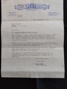 Mont De Lancey
Document - Shire of Lillydale: Planning Application, Shire of Lillydale, 12th September, 1974
Vintage legal documents for land division in Victoria, especially those predating the Torrens system (October 1862), are often found in the Public Record Office Victoria (PROV). These documents, like deeds and Crown grants, can help trace the history of land ownership and division. A letter from K.H. Scott, Shire Engineer of the Shire of Lillydale Victoria to M. H. Proctor Re: Planning Application P.S./833. It is typed on the blue elaborately printed Shire letterhead and dated 12th September, 1974. The application from Mr Proctor to subdivide land situated and described as C.C. 12 Sec B Queens Road., Wandin was granted. Conditions apply.Signed 'Yours faithfully K H Scott K.H. Scott Shire Engineer' 'In reply please quote 1832:74 MGE:DW'legal documents, contracts, documents, indentures -
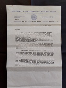 Mont De Lancey
Document - Land Permit to Subdivide Land, Melbourne and Metropolitan Board of Works, 5th July 1974
Vintage legal documents for land division in Victoria, especially those predating the Torrens system (October 1862), are often found in the Public Record Office Victoria (PROV). These documents, like deeds and Crown grants, can help trace the history of land ownership and division. A letter from the Melbourne and Metropolitan Board of Works stating the application by Mr M. H. Proctor of Wandin dated 23rd April, 1974 for a permit to subdivide land in Wandin Yallock has been approved by the Board on 23 April, 1974. There are conditions required. The letter is signed: 'Yours faithfully, (O.T. W. Cosgriff) Assistant Secretary' for 'Mr. M. H. Proctor, Queens Road, Wandin, 3139. 'Board's Reference: Appln No, TP 76484'legal documents, contracts, documents, indentures -
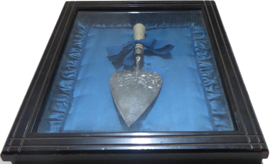 Old Colonists' Association of Ballarat Inc.
Ceremonial object - Trowel, William Bennett, Silver Trowel, c1887
The silver trowel was used for the laying of the foundation stone of the Ballarat Old Colonists' Hall. It was donated to the Old Colonists' Associaiton in 1906. The Old Colonists' Association minutes noted 'Mrs Murray handed to the Secretary the silver trowel presented to the late President on the occasion of the laying of the foundation stone of the Hall.' The silver trowel was used for the laying of the foundation stone of the Ballarat Old Colonists' Hall. It was donated to the Old Colonists' Associaiton in 1906. The Old Colonists' Association minutes noted 'Mrs Murray handed to the Secretary the silver trowel presented to the late President on the occasion of the laying of the foundation stone of the Hall.' "THE OLD COLONISTS' HALL. The foundation-stone of the building to be erected by the Old Identities’ Association, in Lydiard street, was next laid with the usual ceremonies. This was immediately adjoining the foundation-stone of the Mining Exchange building. Mr J. Graham presented Mr Murray with a silver trowel, bearing the following inscription:—“ Queen Victoria’s Jubilee. Presented to J. P. Murray, Esq., president of the Old Colonists’ Association, on the occasion of his laying the foundation stone of their new hall, Ballarat, 21st June, 1887.” Mr Graham said he thought the pioneers of such a city were quite right in erecting a building that would be a home for them while they lived, and a memorial of them when they were no more. Mr J. Fraser, secretary, read the followin'- report:— “Mr Chairman, ladies, and gentlemen,—The bottle about to be deposited under this foundation contains documents in which are written particulars of the founding of the Old Colonists' Association at Ballarat; its financial and numerical position at the present time, the names of its officers and committee of management for the current term: a complete list of the names of its members, a copy of the rules and regulations of the association: copies of The Star, Evening Star, Courier, and Ballarat Advertiser newspapers, programme of to-day's proceedings as far as they relate to the laying of the foundation-stone, together with a brief summary of the aims and objects of this philanthropic institution. That the nature of these objects are considered worthy of encouragement and support is amply proved when we see on the Association's roll of membership the names of so many of our most prominent citizens and public men, "and from the fact that the Government of the colony have recognised the just claim of the old colonists'of Ballarat to be placed in possession of this valuable and central site, upon which to erect a building that will, be a credit to them and an ornament to the city, and which will enable them to still further extend the sphere of their benevolence and usefulness iu this district. The following is a copy of the signed and sealed memorial document:—*The foundation-stone of the hall of the Old Colonists’ Association of Ballarat; was laid on Her Majesty Queen Victoria's Jubilee Day,- Tuesday, 21st June, 1887, by John Paul Murray, Esq., J.P., president of the association. Under the foundation stone is deposited a copy of the constitution and rules of the association, the names of the officers, and a complete list of the names of ail the members to date; also a copy each of The Star, Courier, Evening Post, and the Advertiser, local newspapers. At this date the association numbers 319 members—accumulated funds, £203 10s 3d. The land upon which the hall is to he erected was granted by the Government to the association for that, purpose. (Signed) John P. Murray, President; W. B. Perry, Samuel Delpratt, Vice-presidents; Daniel Fern, Treasurer; John Fraser, Secretary. Committee—J. W. Graham, J. W. Lee, James M'Merkin, Andrew Lister, James Ward. Trustees—J. W. Graham, Wm. Irwin, John M'Cafferty ” Mr Murray said he was proud to lay the foundation stone of this building. The association was started in I883, and he might say they were a purely philanthropic institution. They formed an association whose creed was to assist one another in every shape and form. They had now 319 members, and were daily increasing in number.-. They were very fairly off as regarded their financial position. With respect to the objects of the association, they were to form a bond of brotherhood among those whose past experience in commercial or in mining pursuits so intimately associated them with the early history of the goldfields; men, to whose indomitable energy and perseverance Ballarat and other mining centres in the colony were so largely indebted for their development and commercial prosperity. Some of whose names were also closely identified with the memorable and sanguinary struggle 'for freedom and constitutional liberty in 1883. Their object was, further, to gather together within one fold those who survive those stirring times, to meet occasionally in friendly and social intercourse; to relieve their brethren who were overtaken by sickness or affliction; to provide the shelter of a home for those Pioneers of the goldfields whom the reverses of fortune had deprived of the means of procuring the comforts of life in their declining years; to assist the widow and succor the orphan; to mutually cheer and support each other in their temporary troubles and vicissitudes as they journeyed onward to the grave; and lastly, to tender a tribute of respect to the memory of a departed brother, by following his remains to their final resting place. Such were some of the principal objects of the “ Old Colonists' Association.” It was an institution for the good of their fellow man, and he hoped it would be successful, he hoped that the young people who came after them would appreciate what the Old Colonists had left them. He hoped they would all assist in making the institution one that would he worthy of the place. He would hand a small donation to the secretary, and hoped others would do the same. (Cheers.) The secretary, amid cheering, announced that the cheque handed over by Mr Murray was for £2O. Archdeacon Julius, who was asked to speak, said nothing could have been more fitting than the laying of the foundation-stone of the Old Identities’ Association on the Queen's Jubilee. They were a link between the past of 50 years gone by and today. Many of them remembered well enough perhaps the time when it took a man five and twenty minutes to light his pipe with tinder and steel, and when the small boys went, up the chimneys to sweep them. (Laughter.) They were building something now that people would look upon in years to come, and speak of in connection with the Old Colonists, if the young men were' half as good as their fathers they would be uncommon good fellows, and he did not think they would be. (Laughter, and interjection.) ''An old fellow said it was very true, and he knew it. (Laughter.) The Old Identities would agree with him to a man. (Laughter.) If the young men walked in their steps Ballarat in another 50 years would be 50 percent, better than it was now. There was not a man there that wished that more strongly, than 'he’ did. The Old Identities were laying this stone on the jubilee day of Her Majesty, and there never sat on the throne a worthier or nobler Queen than she who held her jubilee that day. There was not a man present, whatever his views of government may be, who did not say “God bless our Queen.” (Cheers.) The proceedings closed with the singing of the National Anthem and cheers for the Queen. (Ballarat Star, 23 June 1887)Silver trowel used during the laying of a foundation Stone for the Ballarat Old Colonists' Association building in Lydiard Street North, Ballarat.ballarat old colonists' association, ballarat old colonists' club, trowel, silver trowel, foundation stone, mrs j. murray, william bennett, j. fraser, john murray, w. lee, william irwin, john m'cafferty, john mccafferty -
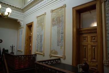 Old Colonists' Association of Ballarat Inc.
Photograph - Photograph - Colour, The entrance foyer of the Old Colonists' Club, 2015
From the Argus Newspaper of 10 May 1888: "OLD COLONISTS' ASSOCIATION OF BALLARAT. (FROM OUR CORRESPONDENT.) BALLARAT, WEDNESDAY. This association, which was founded in August, 1883, and at first known as the Old Identities' Association, now has a roll of 450 members. The objects of the association are "to aid and assist indigent or suffering old colonists; to raise a fund, by the voluntary subscriptions of the members and the aid of outside donations, for the purpose of relieving members in sickness and old age ; for assisting those in extreme distress, to provide the shelter o a home for old and indigent pioneers of the gold fields, their widows, or anyone connected with the association, and in the event of the death of any member to have his remains decently buried, the association defraying the expenses of the funeral (providing that no funds or property are left by the deceased), and to attend the funeral if so desired by the relatives " The qualifications for member- ship are good character and repute, and residence in the colonies for a quarter of a century. For some time the association had no property except the regular subscriptions, but about a year ago they obtained from the Minister of Lands the grant of a very valuable block of land in Lydiard-street, the Crown grant of which they received last week. This block has a frontage of 66ft to Lydiard street, worth at least £100 a foot. The ground was given to the association as a site for them to build a hall upon, and with so valuable an asset they had no difficulty in borrowing at 7 per cent, enough money to construct a hall. For revenue purposes the ground floor of the building has been made into four shops, and the rental from these, judging from the rentals of shops in the vicinity, will not only pay all the interest on the borrowed money, but over £200 a year towards clearing off the principal. The officers of the association are Messrs J P Murray, president; J W Graham and T. Stoddart, vice presidents; D Fern, treasurer , and J Fraser, secretary. The Old Colonists' Hall is an elegant looking building in Lydiard-street, lying between the newly-opened mining exchange and the Commercial Club house, and a few doors north of the Post office. The style of the facade is classic. The lower portion of the front is constructed of Waurn Ponds stone, forming piers, and the upper portion of brick and cement, the background being tuckpointed. The centre bay is carried by two three quarter columns with Ionic cups, which support a pediment on which is set a cast of the Ballarat coat of arms. The four other bays are supported by pilasters with Corinthian caps mid partly fluted. The entrance is through a spacious circular headed doorway, the keystone of the arch of which bears a sculptured head, in marble, representing that of the president of the Old Colonists' Association here, Mr. John P Murray. An ample vestibule leads to a wide stone staircase which ends at a spacious landing. The landing has a dome over the centre, with cornice and enrichments, and is lighted from above. The walls round the landing are panelled with marble slabs, which are to be appropriately inscribed in the future. On the first door are the rooms appropriated to the association. The principal of these is a hall 44ft x 33ft and 17ft high. This room is well ventilated and lighted from the back of the building with large windows, and the walls are finished with Keene's cement. The other rooms are committee room, 14ft x 16ft; scretary's, 14ft x 17ft 6in; kitchen, bedrooms, bathroom, &c. The front portion of the first floor is arranged so that it may be let for offices, or utilised for club purposes. Suitable provision has been made throughout tor lighting, ventilation, and means of egress. The architect for the edifice is Mr A. G Legge, of this city, and the contractors are Messrs. Whitelaw and Atkinson, Irving and Glover, Reynolds, and J Donaldson. The total cost of the building when completed, which will be in a few weeks, will be about £4,000."Colour photograph of a room with marble plaques on the wall. They relate to the Old Colonists' Association of Ballarat, old colonists' association ballarat, old colonists' club, marbles -
 Lakes Entrance Historical Society
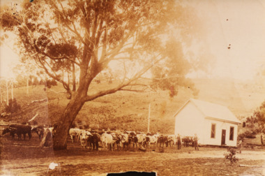
Photograph, George Price Grant Metung, 1900 c
Myrtle Fish collection daughter of George Price GrantSepia toned photograph showing large Bullock team of George Price Grant of Metung moving a small building in Metung district four men visible one on right with an axe other with whips. Bare hill and a few dead trees in background showing early land improvement for agriculture Metung Victoria genealogy, settlers -
 University of Melbourne, Burnley Campus Archives
Plan, Plan of Richmond Park, 1886-1948
(1) Black and white photographed copy of an original coloured plan. Plan of Richmond Park with Horticultural Society Gardens marked in. Includes additional land which became the Field Station. Original plan dated 31 August 1872, note of Crown Grant to the Board of Land & Works and Richmond City Council 1886; showing land, "Permanently Preserved for the Gardens". Stamp, "Department of Lands and Survey Photographed at the Central Plan Office 1/1 Plate 7.12.48" (2) Also 2 photocopies, 1 reduced - possibly used in a publication1 photocopy has "Figure 1. Plan of Burnley Gardens circa 1863 [sic]gardens, richmond, horticultural society of victoria, richmond park, a.l. martin -
 Bendigo Historical Society Inc.
Document - MCCOLL, RANKIN AND STANISTREET COLLECTION: INDENTURE GOLD MINING LEASE 9201 BALLAARAT
6 page document plus map: indenture, gold mining lease dated 9th August 1960, between the Crown and North Deborah Mining Company, carrying on operations in the Parish of Moorarbool West . Key on map indicates depth to which land may be excised. On map: Mining District of Ballarat, County of Grant, Parish of Moorarbool West. Total area: 285 acres 1 rood, 20 perches. Vol 334, Fol 202.bendigo, mining, deborah gold mines -
 Bendigo Historical Society Inc.
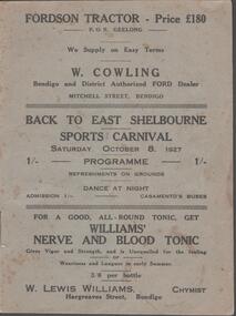
Document - BACK TO EAST SHELBOURNE SPORTS CARNIVAL, 8 October, 1927
Back To East Shelbourne Sports Carnival, Saturday, October 8, 1927. Programme. Refreshments on grounds, dance at night. 1/- Casamento's Buses. Executive Committee: President; W Harris. Vice-President; M De Araugo. Messrs. E Wright, A D Holden, W Hamilton, J Bartels, J Hinck, and H Hinck. Hon. Sec.; H M Burke. Asst. Hon. Sec.; G H Marshall. Ladies; Mesdames J Bartels, H Burke, G H Marshall, E Pocock, R Vines, and E Wright. General Committee; In addition to the above, Messrs. E Pocock, J De Araugo, F J Roberts, and W Marshall, Mesdames W Harris, A Holden, J De Araugo, F J Roberts, and Miss Pocock. Officials Judges: Messrs. T D Cairns, J Craven, and Geo. Hogben. Handicappers: Mr P Davidson (Northern District Walker's Assn.) Starter: Mr W Harris, M De Araugo, J Hinck, H Hovenden, E Pocock, W Hamilton, F J Roberts, A D Holden. Timekeeper: Mr H Hinck. Patrons: Cr, J Bartels, Nuttall & Clarke, Mrs D Punton, R S V Cocking, J Murray, and A Wells. Next 8 pages contain information on the history of East Shelbourne beginning with; This district is situated about ten miles west of south-west of Bendigo on Back Creek or Spring Creek, which received its names from the early diggers of Bendigo who, through shortage of water, were compelled to puddle at Bullock Creek or further 'back,' hence Back Creek; and because of the number of springs it contained - Spring Creek. Among the first to settle, in 1860, were Messrs. John Jenkinson, J Kilgour, T Connelly, G Nichols, R Fox, (who married Mrs James Jenkinson), Kenny, J Roberts, J Genders, J Curry, G Nevinson, Bartram, J Geary, A Nicholl, H Spencer, W Saunders, Mrs Prichard, and J Stansfield. History of East Shelbourne continues . . . Events held were Boy's (State School) Bicycle Race, Stepping the Distance (Gents), Stepping the Distance (Ladies), Bowling at the Stump, Kicking Football Through Hoop, Sheaf Toss, Bucket Ball, Sheffield, Children's Relay Race, Men's Potato Race, Tilting Rings, on Bikes, Walking Contest 1 mile, Car Race through pegs, Slow Bicycle Race 50 yards, Handicap Bicycle Race 2 miles, Tilting Rings in Cars, High Jump, Ladies' and Gent's Cigarette Race, Weight Guessing. Prizes were awarded for first and second placing of these events.In 1923, a Sports Carnival was held in the precincts of what was then a water reserve, situated south of the State School. The area was reserved for watering purposes on 1st May, 1894; and on July 15th, 1912, a small portion was excised. By 1923 its usefulness for water storage had disappeared, and being ideal for recreation purposes, it was decided, at the final meeting of the above sorts carnival, to apply for the area appointed, Mr W Harris (chairman), Messrs. G H Marshall, J Roberts, D Gill, M Connolly, R Vines, E Pocock, and H M Burke (secretary). The matter terminated in a Land Board, presided over by Mr McPherson, being held in Bendigo. The application was granted, but was not gazetted, until Messrs. W Harris and F J Roberts, with Messrs. A E Cook, MLA and Hon. H Keck, MLC interviewed the Minister for Lands. Soon afterwards, at a public meeting, the following members were elected to constitute the first Board of management, Messrs. W Harris (chairman), G H Marshall, A D Holden, F J Roberts (tres.), M D'Araugo, E Wright, and H M Burke (sec.). Since then the arena has been cleared and levelled by residents, and labor and material to the value of 150 pounds have been put into the reserve. At least 2/3rds of the program contain ads from business in Bendigo. Fordson Tractor - W Cowling, W Lewis William's Chymist, Collier footwear, William Wallace Land and Clearing Sales, Bain & Daws Groceries, Farmers & Citizens Trustees Company Bendigo Limited, Northern Seed Supply Co., Marong Bakery, Bennetts' Arcade Store, Marong Hotel, Warren's Drapery & Clothing, Jas. Friswell Butcher, Webster's Wireless, Baker & Woods Tennis Supplies, Hartleys Wireless, Cycle Hartleys, Bendigo Book & Stationery Centre Frank J Every's, T R Jones Chemist, Wool Skins & Hides F Ferguson, Furniture Carpets Linoleums Morley Johnsons, Jewellery & Silverware Prescott & Dawe, Drapers Honan & O'Toole, Stilwell's of Bendigo, Gents' & Ladies' Tailoring Hatters & Mercers Messrs. Denton Bros., Groceries Ales Wines & Spirits W Jeffrey, Ashman's Tailors Hatters Mercers, Myer's, Farmers' Grocery D Whyte & Co., Drapers & Furniture Stores The Beehive, Butcher les. Friswell, Tobacconist & Hairdresser W J Lenten, Timber Merchants & Ironmongers Hume & Iser, Stock E M Vains & Co., Ladies' & Gents' Tailors Clifford & Fulton, Printers & Stationers Bolton Bros. Pty Ltd, Bendigo Leather Shop, Everything Musical Suttons, Andrew's Auction Rooms Butter Eggs Poultry etc, Meats A C Petherick's, Albert Bush's Produce Stores & Chaff Mills, T D Cairns & Co., Jeweller C J Kirby, Casamento's Garage & Ballarat Motor Bus Service, Webster Bros. Sporting House Cycle Builders Motor Cycle & Car Agents, British Motors Bendigo, Webb's Bacon Depot. 20 pages plus coverBoltons Print, Bendigoevent, social, east shelbourne sports carnival -
 Wooragee Landcare Group
Photograph, 2004
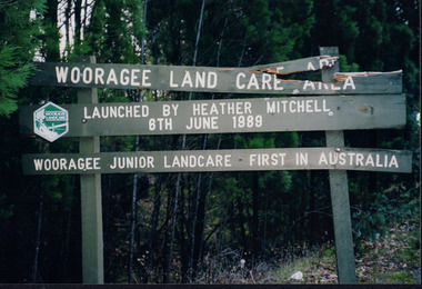
This photograph of the Wooragee Landcare Area signage was included in the album alongside the statement that, when the photo was taken in 2005, the Wooragee Landcare Group had applied for a council grant for new signs with which they could replace the broken sign in the photograph. The sign marks the Woooragee Landcare Area, opened in 1989 by Heather Mitchell, one year after the first meeting of the Wooragee Landcare Group. It also commemorates the 1898 founding of Wooragee Junior Landcare, which they launched with Wooragee Primary School. As stated by the sign, Wooragee Junior Landcare was the first group of its kind in Auatralia, with the nation-wide Junior Landcare organization being launched in 1998. This photograph is significant as a marker of Wooragee Landcare's need for grants and council funding, which is common to many organisations, and for demonstrating the history of Wooragee Landcare and Junior landcare by commemorating the founding of both the Wooragee Landcare Area and Wooragee Junior Landcare. Rectangular landscape colour photograph printed on gloss photographic paper.Obverse: Sign in photograph reads "Wooragee Land Care Area/ Launched by Heather Mitchell/ 6th June 1989/ Wooragee Junior Landcare First in Australia" Reverse: "WAN NA E0NA0N2. AIN+ 1 2906/ wooragee junior landcare, grants, signage, council, wooragee landcare area, heather mitchell, wooragee primary school, wooragee, wooragee landcare, wooragee landcare group, junior landcare, 1989, broken sign, youth, junior, children, landcare, landcare area, founding