Showing 2524 items matching "melbourne water."
-
 Eltham District Historical Society Inc
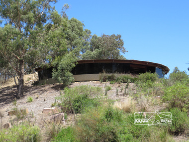
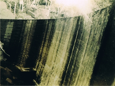
Photograph, Sugarloaf Reservoir, Christmas Hills, 16 January 2015, 16 January 2015
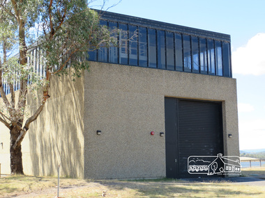
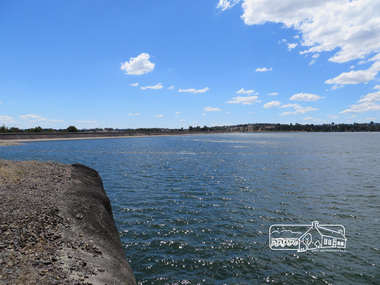
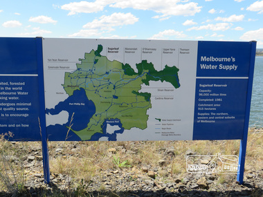
Sugarloaf Reservoir is situated on former farmland. This large water storage was completed in 1982 and serves Melbourne's northern suburbs. Within the visitor areas are two picnic grounds and other recreational facilities. Below its massive rock embankment is located the Winnecke Treatment Plan designed to purify its water before being piped into Melbourne. The dam partly inundated the old firing ranges of the former Christmas Hills Rifle Club. Source: Christmas Hills Now and then: Yarra Glen & District Historical Society, 2004. Born Digitalchristmas hills, sugarloaf reservoir -
 Eltham District Historical Society Inc
Photograph, Sugarloaf Reservoir, Christmas Hills, 16 January 2015, 16 January 2015
Sugarloaf Reservoir is situated on former farmland. This large water storage was completed in 1982 and serves Melbourne's northern suburbs. Within the visitor areas are two picnic grounds and other recreational facilities. Below its massive rock embankment is located the Winnecke Treatment Plan designed to purify its water before being piped into Melbourne. The dam partly inundated the old firing ranges of the former Christmas Hills Rifle Club. Source: Christmas Hills Now and then: Yarra Glen & District Historical Society, 2004. Born Digitalchristmas hills, sugarloaf reservoir, signage -
 4th/19th Prince of Wales's Light Horse Regiment Unit History Room
Water bottle
... Macleod melbourne This type of water bottle was used by mounted ...This type of water bottle was used by mounted troops from @1914-1945 This type of water bottel was used by soldiers of 4th, 17th and 19th Light Horse Regiments til 1944Metal water bottle enamalled and surrounded in khaki wool cloth held in a leather frame and suspended from a leather shoulder strapF. S. Ltd 1941 shoulder, mounted, bottle, strap, water -
4th/19th Prince of Wales's Light Horse Regiment Unit History Room
Water bottle
Standard Army issue item. Original owner not knownArmy issue water bottle. Steel construction with blue baked enamel finish. Housed in khaki felt jacket. In leather carrier. No strap.Leather has manufacturer's stamp; "WHITEHOUSE & HARTLEY WALSALL 3038" Stopper marked "DD", Defence arrow and "QP"water bottle -
4th/19th Prince of Wales's Light Horse Regiment Unit History Room
Millbank filter bag, M & Co
Personal issue equipment during World War 2 and Vietnam War eras. It did not purify water but stopped one from drinking mud. The filtered water was run in to a water bottle containing sterilizing tablets.Light green cotton bag. Fitted with brass eyelets in top corner for use as hanging point.Manufacturer's stamp: "M & Co. 1945, Defence broad arrow, CAT No A.F. 0005" -
4th/19th Prince of Wales's Light Horse Regiment Unit History Room
Photo, Light Horse Parading at Race Course
Photo is believed to be of the 3rd Light Horse Regiment parading at Morphetville Race Course, South Australia prior to embarking for service in World War 1B&W photo of an Australian Light Horse Regiment formed up on a race course. Includes support wagons and a Furphy water cart. Mounted on cardboard backing.Not any3rd light horse, photo -
4th/19th Prince of Wales's Light Horse Regiment Unit History Room
Photograph collection, Palestine Campaign, not known
Set of 24, A3 prints of photographs relating to the Palestinian campaign of World War 1. In A3 museum quality presentation binder. Photo captions: Cover. The final drive Jerusalem to Damascus September 1918 (print not included). 1. "German Aviator's memorial "Jenin". 2. British and Indian cavalry watering horses at "Jenin". 3. German and Turkish prisoners captured at "Jenin" 4. Abandoned enemy transport at Nazareth Hill 5. "Nazareth". Cavalry in occupation 6. "After the charge. By 4th A.L.H. Bde at Semakh 7. "Semakh station" A scene of German treachery 8. 8th A.L.H. bivouaced near Galilee 9. Coming Storm "Sea of Galilee" 10. A picnic on the shore of Galilee 11. Ruins of Capernaum 12. Bedouin children. "Capernaum". 13 Jisr Benat Yakub (Bridge of Jacob's Daughter) upper Jordan 14 Examining prisoners "Benat Yakub" 15 Moving up, Motor Lorries with material for repairing Bridge "Benat Jacob". 16 Kuneitra 17. Aus Div staff with Headmen of "Kuneitra". 18 Hedjaz forces entering "Damascus" 19 Light Horsemen entering "Damascus". 20 L.A.M.B. entering Damascus 21 Inhabitants inspecting Motor cyclists "Damascus". 22 Portion of "Damascus" square Day of occupation 23 Prisoners herded in Damascus square 24 The morning after "Barada Gorge Damascus" -
4th/19th Prince of Wales's Light Horse Regiment Unit History Room
Booklet, The Assault Crossing of Water Obstacles. Military Training Pam No 20 Part II Water Crossing Equipment 1947, 1947
... Macleod melbourne Assault water crossings WO Code No 8231 A soft ...A soft covered booklet to provide the unit commander and staff officer with information on available types of water crossing equipmentWO Code No 8231assault water crossings -
4th/19th Prince of Wales's Light Horse Regiment Unit History Room
Photograph, Australian War Museum, 1917?
A black & white photo showing horses being watered at a stream.On back: Members of the 4th ALH Regiment watering their horses from troughs at Auja in the Jordan Valley Palestinephoto, 4th light horse, jordan valley -
4th/19th Prince of Wales's Light Horse Regiment Unit History Room
Photograph/Postcard, R McGeehan, Light Horse at Lake Burrumbeet, 1914
A sepia toned photograph of a light horse regiment watering its horses at Lake Burrumbeet Victoria in 1914Watering Horses L H Camp Burrumbeet 1914light horse, lake burrumbeet -
 Kiewa Valley Historical Society
Photograph Clover Dam, Clover Dam Circa 1940, circa 1940s to 1950s
As part of the push to cut electricity costs and diversify supply, the Victorian Government (circa 1930) implemented the conversion strategy from mainly brown coal supply to hydro - electricity. The Kiewa Hydroelectric Scheme became the largest scheme of its kind in the State Of Victoria and the second largest scheme in Australia. This dam was constructed to supply water to feed four turbines (62 mega watts) at the West Kiewa Power Station. This was at the forefront of sustainable "Green" energy. Costs associated with power supplies is still a major incentive of governments, however environmentally friendly alternatives such as wind and nuclear have also made inroads. The Kiewa valley and its surrounding alpine catchment were looked at(Victorian State Government), from the beginning of the twentieth century as a source of alternate power for an every increasing demand for electricity by growing population and heavy industrial ares within Melbourne City and State regions. Construction of dams, such as Clover Dam provided the large quantity holding areas of water required to turn the turbines at the various power stations to provide the electricity needed. The impact of these controls by moderating water run off from the alpine regions is beneficial in reducing flooding from thawing of snow on the alps. This by-product allows agriculture and grazing to be less vulnerable to seasonal flooding thereby resulting in a more stable annual production level.Reproduction (scanned) of a black and white photo of Clover Dam circa 1940. The paper used is KodakXtraLife II paperThe reverse side of photo " KodakXtraLife II paperdams, pondage, hydro electricity, power stations, clover dam, secv -
 Kiewa Valley Historical Society
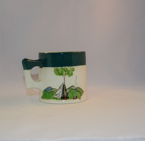
Mug Stoneware
This ceramic mug is titled "Bill Bogong's Mug" in honour of one of Australia's Scouting (Rovers) notable office holders, Mr.W.F."Bill" Waters. He was born on 22nd August 1897 in Taralgon, Victoria, Australia and died 8th October 1968 in Fitzroy, Victoria. He was instrumental in the Rovers building two chalets in the Victorian Alps. The Victorian Award of the National Rover Service Award(1980) has been named after Bill Waters. Bill Waters was also the leader of the first team that climbed Mount Bogong in winter in 1929. Also was part of rescue team of what is now know as the Cleve Cole tragedy on Mt Bogong in the mid 1930's. There is also a water fall named after him Waters Falls on the Bogong High Plains. W.F."Bill" Waters aka "Bill Bogong" (Bogong mountain, were his ashes were scattered), was not only a prominent bush walker (Melbourne Walking Club) of the high country (Victorian Alps) but was instrumental in establishing two Chalets. One of these Chalets was the first one to be built on the Bogong High Plains. This item, "Bill Bogong's Mug" is what the Flinders Petrie(famous English Egyptologist/Archaelogist) Rover Crew(formed in 1940) presented newly invested members of the exclusive(200 membership) Alpine Rover Crew. The Melbourne Walking Club has a long history with the Victorian High Plains area, of which the Kiewa Valley is an integral part of the Victorian Alpine Region. Due to the connections Bill Waters has with the Bogong High Plains and Mt Bogong this cup has a lot of significance to the social history of the area.. Round glazed stoneware mug, white in colour, with a heritage green coloured band covering the top rim and handle. Written inscription on the front "Bill Bogong's Mug" in large print and beneath it, in smaller print, "with compliments from Flinders Petrie Rover Crew" The other side of the mug is a free hand landscaped drawing of green bush and blue hills with a tree supporting a tent and a camp fire (with smoke rising from it).To the left of the inscription is the Scout (Rover) emblem coloured black with an unraveled and unwritten signage scroll fowler ceramics, local alpine history, alpine rovers, scouts, mugs, mt bogong, bogong high plains -
 Eltham District Historical Society Inc
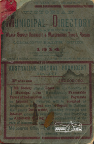
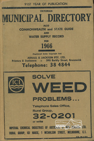
Book, Arnall & Jackson Pty ltd, Victorian Municipal Directory 1914 published by Arnall & Jackson Pty. Ltd, 1914
Victorian municipal directory and Commonwealth and state guide and water supply record for 1914xxiv, 743 pages ; 19 cm.government commonwealth and victoria, water supply victoria -
 Eltham District Historical Society Inc
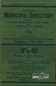
Book, Victorian Municipal Directory 1955 published by Arnall & Jackson Pty. Ltd, 1955
Victorian municipal directory and Commonwealth and state guide and water supply record for 1955xxxiv 1071 p. ; 19 cm.government commonwealth and victoria, water supply victoria -
 Eltham District Historical Society Inc
Book, Arnall & Jackson Pty ltd, Victorian Municipal Directory 1966 published by Arnall & Jackson Pty. Ltd, 1966
Victorian municipal directory and Commonwealth and state guide and water supply record for 1955xxiv, 1150 pages ; 19 cm.government commonwealth and victoria, water supply victoria -
 Eltham District Historical Society Inc
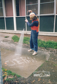
Photograph, Gerni High Pressure Water Cleaner - Engineering Design
One of a set of display images thought to be produced by the Shire of Eltham c.1979-1987Illustrative of services provided by former Shire of ElthamColour photograph 20 x 29 cm mounted on green-painted chipboard 28 x 35.5 cm (string on back for hanging)Title printed on label adhered to board below photograph (replaced June 2017)cleaning, maintenance -
 Eltham District Historical Society Inc
Magazine, Sun News-Pictorial, Bush Fires: A pictorial survey of Victoria's most tragic week, January 8-15, 1939, 1939
THE WEEK REVIEWED (Article; Bush Fires: A pictorial survey of Victoria's most tragic week, January 8-15, 1939. Published in aid of the Bush Fire Relief Fund by the Sun News-Pictorial in co-operation with its newsagents, pp2-3) THE fiercest bush fires Australia has known since its discovery are quiescent at the moment, and Victoria, in the comparative coolness of the change which came with rain on Sunday night, has begun·to count its losses. In the fiery eight days, from Sunday to Sunday, at least sixty-six men, women and children have lost their lives in forest fires, or have succumbed to burns and shock; many others have died from heat; and several serious cases of burns are being treated in hospitals. Two babies in Narrandera district have died, and ten others are in hospital, because of milk soured by the record temperatures of those eight days. Forest damage totals at least a million pounds, and incalculable damage has been done to the seedlings which were to have been the forests of the future. Water conservation will be seriously affected by the silting-up of reservoirs and streams from which protective timber has been taken by the all-engulfing flames. More than a thousand houses have been destroyed, and these, with 40 mills, and schools, post-offices, churches, and other buildings, represent a loss of at least half a million. At least 1500 are homeless. For their aid, money raised in appeals has now passed the £50,000 mark, and the biggest relief organisation ever set up in peace time has swung into operation. The First Hint Victoria's first hint of what was to come appeared on Sunday, January 8, when most parts of the State awoke to find a blistering day awaiting. At 12.20 p.m., when the thermometer reached its highest for the day, 109.6 degrees, the first fire victims were at that moment going to their death on a bush track five feet wide off the main road to Narbethong. They were the forestry officers Charles Isaac Demby and John Hartley Barling, who went to warn Demby of his danger when he parted from his companions, and was himself surrounded by the treacherous fire. It was not until 8 o'clock next morning that the tragic news was flashed throughout the State. Searchers found the two charred bodies close together, one seeking protection in the nook of two logs. Barling's watch had stopped at 1.20. In the meantime, tragedy was spreading its cloak. By Monday, big fires were raging at Toolangi, Erica, Yallourn, Monbulk, Frankston, Dromana, Drouin South, Glenburn, and Blackwood, with smaller outbreaks at many other centres. In the ensuing week, while women and children were evacuated as fast as the flames would permit, Erica-scene of the 1926 fire disaster-thrice escaped doom by a change of wind. Indeed, those who have been in the fire country these past days say that the numbers of times a change of wind has saved towns from destruction is amazing. In the towns they speak of miracles. Monday's Miracles The escapes from Monett's Mill at Erica and from the Hardwood Company's Mill at Murrindindi, near where Demby and Barling went to their death, were Monday's miracles. Twenty came out alive from each mill. At the first a 60ft. dugout provided an oven-like refuge; at the second, 12 women and children survived in the smoke-filled gloom of a three-roomed cottage while their eight men, their clothes sometimes afire, poured water on the wooden walls. Three houses out of ten remained when the fire had passed. Record Temperatures Sunday had been the hottest Melbourne day for 33 years; Monday dropped to a 76.1 degree maximum; but Tuesday dawned hotter than ever, the mercury reaching 112.5. By now rumor was racing ahead of fact; whole towns were being reported lost; the alarm was raised for scores of missing persons. But fact soon overtook rumor, and within a few days the staggering toll began to mount to a figure beyond the wildest imaginings of the panic-stricken. Six died from heat on this torrid Tuesday, and the fires spread in a wide swathe from south-west to north-east across the State. Fish died in shallow streams. A curtain of smoke hid the sky from all Victoria, and hung far out to sea. It alarmed passengers on ships. On the Ormonde, on the voyage to Sydney from Burnie, women ran on deck, believing fire had broken out in the hold. Days later the smoke reached New Zealand. In Melbourne thousands of fire-volunteers were leaving in cars: vans, motor-buses-anything reliable on wheels-to aid the country in its grim fight. In the fires at Rubicon and. Narbethong, seventeen were facing death this day. But not till Wednesday, when Melbourne breathed again in a cool change, while the country still sweltered in temperatures up to 117 degrees, did the news come through the tree blocked roads. A woman and her little daughter, trapped on the road, were among those who died. Their bodies, and those of menfolk with them, were found strewn out at intervals along the road, where the furnace of the surrounding fire had dropped them in their tracks as they ran. Twelve died at a Rubicon mill, five on the road at Narbethong. At Alexandra, not far distant, a baby was born while the fires raged, and stretcher-bearers brought in the injured. On Thursday the State Government voted £5000 for the relief of fire victims. The Governor (Lord Huntingfield) and the Lord Mayor (Cr. Coles) visited some of the stricken areas, and dipped into their pockets personally. Later, the City Council, too, voted £5000. Friday, The 13th Friday, the Thirteenth, justified its evil name. A blistering northerly came early in the morning, presaging destruction, and forcing the mercury to a new record of 114 degrees. Racing fires killed at least ten in those terrible 12 hours. Four children were engulfed in the furnace at Colac. Panic drove them, uncontrollable, into the smoke-filled road when the fire raced down behind their home. They choked to death. In other parts fires were joining to make fronts of scores of miles. Kinglake was being menaced on two fronts, £60,000 worth of timber was going up in smoke in Ballarat district. Warburton was surrounded. Residents at Lorne, favoured resort, were being driven to the sea-front by a fire which destroyed at least 20 homes. Healewille. with flames visible from the town at one stage, was in a trough between two fires which burned four guest-houses, seven homes and left its surrounding beauty-spots wastes of bowed-over, blackened tree-fern fronds; with its famous Sanctuary, however, intact. Most of Omeo was destroyed this black day: Noojee. while 200 residents crouched in the river, was being reduced to a waste of buckled iron and smoking timber; Erica was once again saved by a change of wind. Beneath a pall of smoke, the Rubicon victims were buried at Alexandra. Friday night and the early hours of Saturday saw the streets of beleagured towns strewn with exhausted fire-fighters. Their flails beside them, ready for the next call, they lay where exhaustion overtook them-on footpaths, beside lamp-posts, in gutters, in cars, under trucks. Saturday's dawn brought clear skies and lower temperatures in many parts, and from the burnt-out areas came a great rush of tragic reports. The death-roll rushed past the fifty mark with incredible speed. Some had been trapped on roads, others at mills; some, after burying their treasures, had clung too long to the places they had made their homes for many years. Four men lost their lives because one went back for his dog. By Sunday, when the first of the saving rain came, nearly another score of names had been added to the list.Newspaper magazine, 48 pages (incl. covers). Fully digitised and searchable PDFPublished in aid of the Bush Fire Relief Fund by the Sun News-Pictorial in co-operation with its newsagents.bushfires, 1939 bushfires, black friday, warrandyte -
 Eltham District Historical Society Inc
Photograph, Main Road, Eltham South, near Eltham Park, flooded by the Diamond Creek, 30 Nov. 1934
Near Eltham Park (now known as Eltham Lower Park), floodwaters from the Diamond Creek cut off the Main road into Eltham at Bremner’s Flats (present day Wingrove Park). In the distance, left of centre, is Mr. Montieth's Ford Wagonette stranded in the floodwater near Wingrove Cottage. “On the Lower Eltham Reserve the water was nearly five feet deep across the reserve and over a mile along the road. All the week-end shops are surrounded. For over 40 years flood waters have not reached this unprecedented level.” - Advertiser, Friday November 30, 1934, p7 "Whilst we were at the shop a "tidal" wave occured . There used to be a Mr. Monteith who ran a Model T Ford bus from the Eltham Railway Station down the main street. The bus would hold seven, six seated in the back, 3 aside a seventh standing on the step on the middle of the back hanging on to two small hand rails. The bus was caught by the flood and was abandoned not far from our shop in the paddocks towards the Higher Elementary School. It was there for days and after the flood waters receded, Mr. Monteith, after removing all the mud and debris gave the engine one turn with the handle and it started first time! So the story goes! " (Doug Orford Reminiscences, 2004) The 1934 flood of the Diamond Creek and Yarra River is the highest recorded flooding in the district and set the standard for the current planning flood plain level.Black and white photograph showing the floodwater from Diamond Creek across Main Road in 1934. Left of centre shows Mr. Montieth's Ford Wagonette in the floodwater in the distancefloods, main road, eltham south, diamond creek (creek), wingrove cottage, wingrove park, bus services, bremner's flat, eltham park, ford wagonette, mr. montieth, floodwater, reminscences -
 Eltham District Historical Society Inc
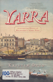
Book, Kristin Otto, Yarra : a diverting history of Melbourne's murky river / Kristin Otto, 2005
"It was John Wedge, Batman's private surveyor, who named the Yarra Yarra. In September 1835 he was at the Turning Basin with some Kulin and heard them identify the river as it came over the Falls as, he wrote, 'Yarrow Yarrow'. It was only some months later that Wedge discovered they had been referring to the pattern and movement of water over the Falls, not the river itself. And ever since, it has been the Yarra's fate to be misunderstood: maligned for its muddiness, ill-used as sewer and tip; scooped, sculpted, straightened and stressed, 'cleaned up' to the detriment of its natural inhabitants; built-over, under and beside; worked mercilessly and then bridged almost to maritime extinction. In Kristin Otto's superbly entertaining new history, the whole sorry tale is laid bare. From the creation stories of Kulin owners and geologist blow-ins (and Robert Hoddle's bad-tempered expedition to the headwaters) to the twenty-first-century waterside building boom, Otto traces the course of Melbourne's murky river. Erudite, affectionate and witty, with more meanders and diversions than the river itself, Yarra is both a fascinating read and a fitting tribute to the 'noble stream'." -- Publisher's website.Paperback; [viii], 245 p. : illus., maps ; 24 cm.ISBN 1920885781yarra river -
 Eltham District Historical Society Inc
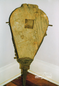
Photograph, Blacksmith's Bellows, Hand water Pump and Steam Time Whistle used at Briar Hill Timber Mill, Heritage Week, 1990, 1990
Three colour photographs of Blacksmith's Bellows, Handwater Pump and Steam Time Whistle used at Briar Hill Timber Mill, Heritage Week, 1990heritage week, eltham, courthouse, blacksmith bellows, hand water pump, steam whistle, briar hill, timber mill, activities -
 Eltham District Historical Society Inc
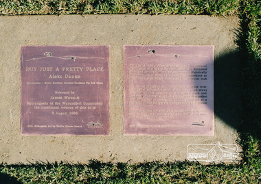
Photograph, Not Just a Pretty Place, Aleks Danko (2000), Lennister Farm, Eltham South, 2000c
Not Just a Pretty Place acknowledges the cultural significance of this site for the residents of Nillumbik Shire and for the Wurrundjeri community. Historically the confluence of rivers have particular importance as these were sites where rituals and ceremonies took place. The carved bluestone form presents an oversize river pebble that echoes the spirit of the water and draws attention to this location as a meeting place an landmark. Awarded the 2000 Nillumbik Art in Public Places Award and situated behind Lennister Farm near Yarra ParkColour photograph printaleks danko, eltham, lennister farm, yarra park -
 Eltham District Historical Society Inc
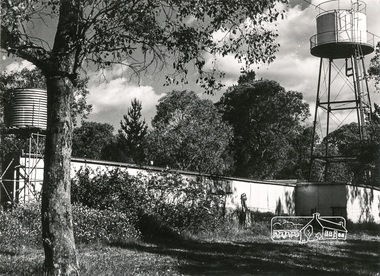
Photograph, Water tanks
... melbourne pioneers and painters water tank Black and white ...Black and white photograph of a building with two water tanks on towers (at Montsalvat?)pioneers and painters, water tank -
 Eltham District Historical Society Inc
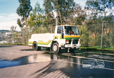
Photograph, Council water tanker
Three colour photographs of Shire of Eltham truck-mounted water tankereltham shire council, equipment, water tanker, trucks -
 Eltham District Historical Society Inc
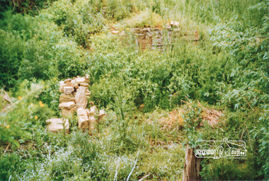
Photograph, Ruins of Coulstocks Mill, Janefield, South Morang
Mill Park Farm at Janefield on the Plenty River was established around 1840 by George Coulstock where he grew wheat. His flour mill was one of the first in Victoria, under construction as early as 1841. After bushfires and Coulstock's early death in 1842, the farm and its mill were taken over by local landowners Henry Miller and John Brock. Peter Hurlestone took charge of the mill. With water diverted from the Plenty River to fill the newly built Yan Yean Reservoir which opened in 1857, the Hurlestone family quit and that was the demise of the mill.Four colour photographs showing the ruins of Coulstocks Flour Mill (Janefield Mill), Janefield. 1. Stone wall 2. Old mill 3. Stone remains of old mill 4. Tree near old mill sitemills, flour mills, coulstock, janefield, plenty river, ruins, stone walls, plenty gorge, bundoora -
 Eltham District Historical Society Inc
Photograph, Ruins of Coulstocks Mill, Janefield, South Morang
Mill Park Farm at Janefield on the Plenty River was established around 1840 by George Coulstock where he grew wheat. His flour mill was one of the first in Victoria, under construction as early as 1841. After bushfires and Coulstock's early death in 1842, the farm and its mill were taken over by local landowners Henry Miller and John Brock. Peter Hurlestone took charge of the mill. With water diverted from the Plenty River to fill the newly built Yan Yean Reservoir which opened in 1857, the Hurlestone family quit and that was the demise of the mill.Five colour photographs of ruins of Coulstocks Mill, Janefield (Mill Park - Bundoora)mills, flour mills, coulstock, janefield, plenty river, ruins, stone walls, bundoora, plenty gorge -
 Eltham District Historical Society Inc
Folder, Peter Dousset, 1983
Contents: 1. Letter from Peter Dousset of Collaroy Plateau, NSW, Nov. 1983. Provides brief history of family origins in district. Grandfather was a French migrant who married an Australian woman in 1883 in Panton Hill and had four boys and two girls. Father worked for Ryan's Butcher shop in Panton Hill for many years. Parents retired to Hillside Avenue Eltham. Mother was kiiled by Burgoyne's truck in 1970 outside the Burgoyne shop (Inquest held Melbourne, 16 Dec 1970 VPRS 24/P0002, 1970/2408). Peter Dousset opened a garage in Research in 1948 with Kevin Brinkkotter and they started the Research Fire Brigade using his breakdown truck towing a water trailer. 2. Copy of death certificate, Ernest Pierre Dousset 13 May 1963 (VIC 9061/63), son of Pierre Francois Dousset and Christina Dousset (nee Newlands), buried Smiths Gully Cemetery (Queenstown Cemetery) 3. Copy of death certificate, Gladys Dousset (nee Stutley), 12 Oct 1970 (VIC 885/71), daughter of Alfred Stutley and Ester Stutley (nee Thomas) 4. Copy of six pages extracted from an autobiography written by Peter Dousset 5. Copy of photo taken 1912 outside the Panton Hill Hotel with Peter Dousset's grandparents on the right side 6. Copy of photo of the Dousset family home in Panton Hill 7. Copy of vaccination certificate of Pierre Dousset aged 6 months at Panton Hill, 26 October 1897 [Items 2-7 are digital file copies only] Folder of information on Peter Dousset and ancestors, Panton Hill and Researchpeter dousset, burgoyne's shop, eltham, kevin brinkkotter, panton hill, research (vic.), research fire brigade, ryan's butcher shop, panton hill hotel, hillside avenue, alfred stutley, christina dousset (nee newlands), ernest pierre dousset, ester stutley (nee thomas), gladys dousset (nee stutley), pierre francois dousset, queenstown cemetery, smith's gully cemetery -
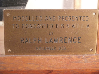 Doncaster RSL Sub Branch
Model of HMS Matabele
Model of Tribal Class Destroyer. Ship 1870 tons 370 feet x 36 feet 6 inches beam. Grey down to water line black below water line.Ship built Scotts at Greenock completed 29-3-1939 and sunk by "U" boat torpedo Barents Sea 17 January 1942. Modelled and presented to Doncaster RSL by Ralph Lawrence November 1958 -
 Victoria Police Museum
Diary and papers, Diary and papers of Constable Joseph Wyers, 1882
Police diary belonging to Constable Joseph Wyer, issued 1882. Wyer was a member of the water police, many of the pages in his diary record the movements of ships in and out of Port Philip Bay. The loose papers are personal notes, including a letter from his sister and a list of the births and deaths of family members. The list includes the names and dates of death of several of Wyer's children, including a set of twins. It also lists the death of his wife. Small paper diary and four loose folded papersJoseph D. Wyersdiary, police, water police