Showing 773 items
matching property for sale
-
 Canterbury History Group
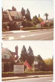
Pamphlet - "Coorinyah", 150 Mont Albert Road, Canterbury, c2001
Real estate pamphlet for the sale of "Coorinyah" 150 Mont Albert Road, Canterbury, includes two extra pages giving description and history of the property and coloured photographs of the interior and exterior.canterbury, mont albert road, coorinyah, elgar's special survey, great railway estate, mellor family, best> sir robert, ussher> beverley -
 Bacchus Marsh & District Historical Society
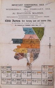
Map, Important Subdivisional Sale at Bacchus Marsh, Wednesday 28 February, 1912, 1912
In the later 19th century and early 20th centuries Thomas Cain was a major farmer in the Bacchus Marsh district and a significant participant in community life and affairs. The sale of some of his most significant properties towards the end of his life generated wide interest in Bacchus Marsh and beyond.Paper. 33cm x 21cmnon-fictionIn the later 19th century and early 20th centuries Thomas Cain was a major farmer in the Bacchus Marsh district and a significant participant in community life and affairs. The sale of some of his most significant properties towards the end of his life generated wide interest in Bacchus Marsh and beyond.land sales, thomas cain, landholders -
 Bacchus Marsh & District Historical Society
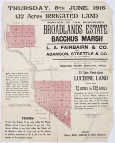
Map - Land Sales Plan, Broadlands Estate, Bacchus Marsh, 1916
This land sales map was produced by real estate agents for an auction of part of a property near Bacchus Marsh known as the Broadlands Estate. 132 acres of irrigated land in 11 separate lots was to be auctioned on the 8th of June 1916. On the 27 May 1916, nine of the 11 eleven lots were withdrawn from sale. The reason stated was due to "road and severance difficulties", according to a notice in the Bacchus Marsh Express newspaper on 27 May, 1916, page.2. When the sale took place on 8th June the two lots were passed in but the local newspaper reported they were expected to be sold privately, see Express, 17 June, 1916, page. 2. The Broadlands Estate was owned by the Miller family whose father Henry Miller, 1809-1888, was a politician and an immensely wealthy financier in Victoria.A typical example of a land sale map of this era. The Broadlands Estate was just over 2,000 acres at its its peak size and was a significant holding of land in the Bacchus Marsh district. Paper printed land sales mapbroadlands estate bacchus marsh, land sales bacchus marsh, farms bacchus marsh, henry miller 1809-1888 -
 Bacchus Marsh & District Historical Society
Map, Bacchus Marsh Township and Nearby Districts Maps Volume
This volume of maps is believed to have been compiled by staff at the Shire of Bacchus Marsh and was presumably used to inform and assist Shire staff and Councillors in the carriage of their duties.This collection of maps are significant due to their rarity as many of them are unique maps made for local purposes in the Bacchus Marsh region. They are also of strong research value containing a wide variety of information including landholders, land sales, infrastructure, such as roads, bridges, public, commercial and private buildings, houses, land use, and geographic features over multiple decades from the late nineteen century into the middle part of the twentieth century.One bound volume of maps comprising cadastral maps, (indicating property owners and land boundaries), land plans and real estate auction plans and advertising material, and other maps indicating major infrastructure like proposed roads and irrigation areas. Most of the maps and plans are of Bacchus Marsh and nearby areas but some maps are of nearby towns such as Melton, Ballan and Blackwood. The volume comprises 52 pages. Most pages have a single map or plan pasted onto it but some contain 2 or 3 different maps. There are 81 maps in total. Map 1 Liquidators Sale 1896. Map 2. Woodside Estate Sale 1913. maps, maps bacchus marsh, maps bacchus marsh region -
 The Beechworth Burke Museum Research Collection
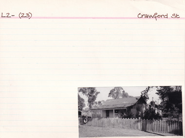
Card (Series) - Index Card, George Tibbits, Crawford Street, Beechworth, 1976
George Tibbits, University of Melbourne. Faculty of Architecture, Building and Town & Regional PlanningIndex system that support the research for Beechworth : historical reconstruction / [by] George Tibbits ... [et al]Arranged by street names of BeechworthEach index card includes: street name and number of property, image of property, allotment and section number, property owners and dates of ownership, description of the property according to rate records, property floor plan with dimensions.beechworth, george tibbitsbeechworth, george tibbits -
 Melton City Libraries
Document, Minns Family Reunion, 2004
"A perpetual spring in the adjacent creek provided a steady supply of fresh water to the site on which the homestead is built. Although we can not be certain of the identity of the builder, the first stage of ‘The Willows’ homestead appears to have been constructed in the mid 1850s. The house is situated on Crown Allotment No.1 (No Section), Parish of Kororoit, an allotment of 5 acres 3 roods 4 perches. Although it had surveyed the land, the Crown did not offer it for sale until 22nd November 1861, at which time it was purchased by Charles March Williams. (Although the property is directly opposite and immediately adjacent to the Township of Melton, and was sold as ‘Suburban Allotment 33’, it was situated within the Shire of Braybrook rather than the Shire of Melton until 1917.) Considerable improvements had taken place on the land prior to the Crown sale. When CM Williams purchased the allotment in November 1861 he paid £23.5.0 for the land itself, and valued the improvements at £400. Even allowing for some exaggeration by Williams, this is an extremely high valuation for improvements, and must have included a house. Some local research has claimed that in 1858 Williams had taken over the interest of a Mr Parkinson in the property, and that Parkinson built the house upon taking possession of the land c.1855. It was definitely built by 1861, when a map shows a square building on the site marked as ‘House’. The property is important in the district for its association with the establishment of the pound. The district pound had been established in 1854, when George Scarborough of Mount Cottrell (Mt Cottrell Road, south of Greigs Road) was appointed pound-keeper. Scarborough resigned in 1857. The pound was moved to Melton following agitation from local farmers and Charles March Williams appointed pound-keeper on 26th April 1858. Williams, the son of a doctor, had been born in London. Reminiscences of local residents of the time, as recorded in the Express newspaper, note Williams’ success in breeding horses on the property. Sales of up to 60 guineas were noted. Whether this was from Williams’s own stock or from unclaimed pound stock is not made clear. Williams appeared before a government inquiry in 1860 and advocated registration of all stock brands in the State. Williams died in 1862 leaving a widow, Catherine, and five living children aged 15 years to five months. At the time of his death Williams had entered negotiations with one Matthew Devenish and had a mortgage of £100 on allotments 1 and 2, Parish of Kororoit. Catherine Williams was appointed pound-keeper on 2 September 1863, with her eldest son Charles as her assistant. Her tenure was short for on 22nd March 1864 George Minns senior paid Matthew Devenish £135 for allotments 1 and 2 Parish of Kororoit (considerably less than Williams had claimed the property was worth in 1861) and on the same day paid William Tullidge £45 for the adjoining allotments 3 and 4. In April 1867, James Ebden Minns, the newly married son of George senior became the owner of The Willows property having entered into a mortgage arrangement with his father to the extent of £200. At the time George Minns was residing in Kaarimba having left Melton in 1867 for a short trip to England and upon his return having taken up a selection in the Kaarimba district with his son Frederick who had a hotel licence there. James paid out the mortgage on 2-1-1873. James Minns was appointed pound-keeper in 1872; in 1885 the pound was moved elsewhere and Minns purchased the old pound site and added it to his farm. The Willows residence underwent a major change about this time. A two room extension, similar in style but with a lower elevation was added to the original rear of the house with a chimney matching the distinctive originals. Window arrangements did not match the original but became a feature of the façade when the new addition became the front of the building. Six buttresses were attached to the east and west walls of the old building, two to the south wall and the whole rendered with mortar to give the appearance of dressed stonework around the windows. Galvanized iron was placed over the shingles and a verandah added on three sides. By 1876 The Willows was the homestead for a thriving mixed farm of 340 acres of which 156 was rented from a H. Ruck. In October of that year the Australasian travelling reporter visited and reported on the property. In common with the nearly every other property in the district the farm had ‘recently’ (generally within the last two years) abandoned cultivation of crops, and turned over completely to cattle pasture. Butter making was the principal occupation of the farm, which had about 50 head of cattle, a large proportion of which were milking cows. The reporter also noted that a ‘large number of pigs are kept upon this farm and are found to be very profitable stock’. Their manure was used in an orchard and garden in which ‘large quantities of lucerne and prairie grass are grown for the use of stock when ordinary feed is scarce’. Two bores attached to deep brick lined wells supplied water for the house in addition to the farm. A commodious timber barn and necessary sheds had also been constructed. Access to the property was improved following the construction of the bluestone ford across the creek c.1887, when the recreation ground came into use. Prior to this date it may have been that the crossing referred to as ‘Mr Minns bridge’ was used. This appears to have been a flimsy structure and has but two references in Council reports in the Melton Express in the 1880’s. It is believed that in the late 1890’s a timber building was added near the rear of the building to house a kitchen, ablutions and laundry rooms and rooms for seasonal workers. This was attached to the house by means of a trellised walkway using the original front entry to the house (long since the back door). A photograph of this building appears in a local history of Melton. This was demolished in recent decades during the period when the house was tenanted (after the Minns family had left). James Minns son, George, took over the property following his marriage to Alice Walsh in 1903. James and Caroline moved into a house on the former JH Games property at the eastern end of Henry Street. George held the position of Shire Secretary for Melton for 40 years. He was a most prominent member of the community being Secretary to, among others, the Melton Coursing Club, the Shooting Club and the Cemetery Trust. He also rode with the hunting parties who sported across the Plains and were entertained at Mount Kororoit. George and Alice had one son, Norman who followed his father into local government and became Secretary of the Shire of Werribee completing a record term in this position. George retired to Werribee in 1951, where he died in 1965. The National Trust records note that James Ebden Minns and his sons were ‘leading men of the district, Justices of the Peace, and Shire Councillors’. It claims that Sir Thomas Bent was a frequent visitor. The Willows passed into the hands of George’s grandson, Bruce Minns and the property was let for a number of years. In the 1960s it became vacant and was subject to vandalism. Major structural problems arose with the part demolition of the roof, the loss of windows and doors and holes dug into and under the floorboards. The outbuildings were particularly targeted. Following widespread public support, the Shire of Melton purchased the house, with 3.75 acres of land, in 1972. In 1975 the Shire of Melton and the Melton and District Historical Society were successful in nominating the building for National Trust classification, and then the Australian Heritage Commission’s Register of the National Estate. The AHC particularly noted its ‘townscape importance’. It was envisaged that the farmhouse would form ‘a picturesque centrepiece to Melton’s planned … historical park, along with Dunvegan bluestone cottage … and similar structures as they become available.’ In a time of great Melton’s ‘satellite city’ development the Council spelt out its broader vision in its submission to the AHC: ‘Melton is destined to become, by the end of the present century, a city of between 75,000 and 100,000 people. Significant relics of the past, such as ‘The Willows’, regrettably will be rare in that situation. It is essential that sufficient tangible links with Melton’s pioneering days remain to promote in the new community a sense of history and continuity’. Under the direction of ‘The Willows’ Restoration Committee and consultant architect John Hitch, all outbuildings, with the exception of the garage and toilet, were demolished and the dwelling house restored. Finances were provided by the Shire of Melton and the National Estate Grants Program, and considerable amount of voluntary labour was provided by the local community. The orchard was removed, and remaining wooden buildings were relocated to provide an open vista for visitors to the Park. The property was furnished with donations from district families keen to preserve this example of pioneer life in the area. The Willows became the headquarters of the Melton and District Historical Society". Invitation to the family reunion at the Willowslocal identities, pioneer families -
Tarnagulla History Archive
Newspaper article - Residents Angry At Tarnagulla Church Sale, Residents Angry At Tarnagulla Church Sale, August 14, 1993
Don Clark Collection. An article from the Bendigo Advertiser newspaper of August 14, 1993 titled 'Residents Angry At Tarnagulla Church Sale'. Outlines community anger at the sale of the Methodist Church in Tarnagulla. tarnagulla, methodist church, property, preservation committee, history work, heritage, lorna goltz -
 Melton City Libraries
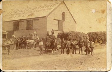
Photograph, 'Melton South Chaff Mill employees, Unknown
Charles E “Ernie” Barrie started constructing a Chaff mill on the corner of Brooklyn and Station road in 1900. It soon became a thriving business and was ideally located close to the railway line. Ernie and his father William and other Barrie brothers had been operated travelling chaff cutters in the district of Melton and Werribee. Within a short time the mill expanded into two big sheds in partnership with his brother James E known as “Ted”. The eldest brother William was in the Manager living in Melton South. In 1906 Ernie applied for a railway crossing on Brooklyn Road to have direct access for railway trucks to be shunted to the mill to be loaded. The Mill was also had the first phone to be connected, No 1, and No’s 2, 3 were the Golden Fleece and Macs Hotels. In 1906 Ernie married Jessie Lang daughter of the Head Teacher at Melton State School No 430 (1896 –1917). The Barrie house on the north side of the mill was completed in August 1906. It survived for almost 60 years until demolition. Chaff mills were very susceptible to fires and often burnt down and would be rebuilt again ready for the peak of the harvesting season. The final demise of the Mill occurred in a spectacular blaze on the night of Friday 2nd December 1977, just before the earth tremor as reported in the local paper. Brian Dobson the local photographer lived close by and captured the night blaze. A video was also taken of the action by the fire brigade. My parents Bon and Edna Barrie were living at 19 First Avenue, and took colour slides of the smouldering ruins in the half -light. Ironically Bon had spent the first year of his life (born in April 1909 and sister Mary born October 1907) at the house beside the mill. Trethowan’s Chaff mill in Brooklyn road was also destroyed by fire, which stated in the evening on Tuesday April 28th 1987. It was established in 1910 by Dixon Brothers, followed by, Ebbot & Kebby, Robinson, Trethowan and Butler and was with the Trethowan family when it burnt down. Melton South was small a community referred to as Melton Railway Station. Member of the community raised the idea to have a public hall. In 1909 Cr Barrie, Mr Nesbitt and Delany formed a committee to build a community hall. Cr Barrie donated the land and The Exford Hall was completed in September 1910 later to be named Victoria Hall. It was demolished in 1992. Colour slide in Barrie archive. In April 1910 the Ernie sold the Mill to Glover Onians (HSK Ward) family moved away to a property in Trundle NSW. Ernie had acquired 640 acres (a square mile) and leased a further 1920 acres of adjoining land. It was the practise of the farmers in the area at the time to buy up or lease the surrounding land from the 640 acre crown land blocks to make up acerage for a viable wheat farm. His wife Jessie found the climate to be very hot and when the Darlingsford property at Melton was put up for sale in the latter part of 1910 and was passed in at the auction. My grandfather saw this an opportunity to return to Melton. The negotiations to Darlingsford were finalised on May 11th 1911. Barrie bothers with connections to Chaff mills and farming in Melton from the 1900s William Henry, Charles Ernest, James Edwin, Samuel John, Robert, Arthur Roger, Albert Walter. Three grandsons and a great-grandson are in business earthmoving and farming in Melton today. (2013) Memoirs by Wendy BarrieEmployees at Chaff Mill, it was located on the corner of Brooklyn and Station Road, Melton South. local identities, agriculture -
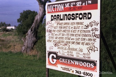 Melton City Libraries
Photograph, Darlingsford sign, Unknown
... Signage for the sale of Darlingsford property... identities local architecture Council Signage for the sale ...The barn is now used as a community function space.Signage for the sale of Darlingsford propertylocal identities, local architecture, council -
 City of Kingston
Pamphlet - Colour, Stillwell and Co, The Hill Estate Highett Great Subdivisional Auction Sale, 1917
Sales plan for land in the suburb of Highett, bounded by Point Nepean Road and incorporating Sandford Street, Turner Road, Alfred Street, Peace Street and Tennyson Street. .The developing urban area of Highett within the City of Kingston. This land sale pamphlet illustrates the subdivision of land within the municipality and the changing demographic of the district as new houses are constructed.Colour pamphlet advertising subdivisional auction sale of the Hill Estate Highett. Incorporates a map of the estate bordered by Point Nepean Road and encompassing Sandford Street, Turner Road, Alfred Street, Peace Street and Tennyson St. Handwritten in grey pencil on reverse: Hill Street / Jamieson Handwritten in blue pencil on reverse: The Hill Estate Handwritten in blue pencil on subdivision map: [tick] [on majority of properties marked on map]highett, land sales, estate -
 City of Kingston
Pamphlet - Colour, H. R. Hill & Co, Walker's Estate, Cheltenham for sale by public auction, c. 1923
Sales plan for land in the suburb of Cheltenham, encompassing both sides of Walker Grove, a section of Centre Dandenong Rd and Axelton St. The developing urban area of Cheltenham within the City of Kingston. This land sale pamphlet illustrates the subdivision of land within the municipality and the changing demographic of the district as new houses are constructed.Black and white pamphlet advertising for private sale the Station Entrance Estate, Highett. Incorporates a map of the estate bordered by Wickham Road, Railway Parade, Highett Road and Point Nepean Road.Handwritten in black pen on subdivision map: 'x' written on subdivisions 2, 3, 8-11, 15-17, 19. Potentially indicating that these properties did not sell at auction. Handwritten in black pen on subdivision map: assumed sale price on subdivisions 1, 4-7, 12-14, 18, 20-31. land sales, cheltenham, estate -
 City of Kingston
Pamphlet - Colour, Duffus Bros, Railway Reserve Highett, c. 1923
Sales plan for land in the suburb of Highett, titled Railway Reserve, incorporating properties along Wolseley Street, Livingston Street, Highett Road and Worthing Road. The developing urban area of Highett within the City of Kingston. This land sale pamphlet illustrates the subdivision of land within the municipality and the changing demographic of the district as new houses and shops are constructed close to infrastructure.Colour pamphlet advertising thirty eight shop and villa sites for sale at the Railway Reserve, Highett. Incorporates a map of the reserve with properties available on Wolseley Street, Livingston Street, Highett Road and Worthing Road. Handwritten in grey pencil: assumed sale price recorded on subdivisions 1-7, 10, 22, 23 and 34 Handwritten in grey pencil on subdivision 4: C. Nevill / City of Melbourne bank Handwritten in grey pencil across subdivision 7: 49' Handwritten in grey pencil across subdivision 21 and 22: 134' Handwritten in grey pencil across subdivision 25 and 26: 200' Handwritten in grey pencil across subdivision 36 and 37 and both top and bottom: 120' Hand drawn in blue pencil: outline of subdivision 4 Hand drawn in blue pencil: outline of subdivisions 7, 23, 28, 37, 38 along left hand side, subdivisions 38, 37 and 36 on Wolseley Street, subdivisions 30 and 29 along Wolseley Street, subdivisions 29 and 24 along the middle of the plan, subdivisions 24 and half of 25 along Livingston Street, half of subdivision 20 along the middle of the plan, subdivisions 21 and 22 along the Right of Way between Livingston Street and Highett Road, and along the right hand border of subdivision 7. Handwritten in ink adjacent to the subdivision plan, updside down, in the bottom right hand corner: 276 / 54 / 280 / 45 / 320 / 202 / 200 / 134 / horizontal line / 11/14 Handwritten in ink adjacent to the subdivision plan, updside down, in the bottom right hand corner: 1714)2200(15 / 1714 / horizontal line / 486land sales, highett -
 Melbourne Legacy
Photograph, Widows' Flats, c.1989
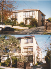
A photo of a block of flats in Sellwood St Hawthorn (top photo) and a block at 9 The Avenue, Windsor (bottom photo) that Legacy owned and leased at reasonable rates to widows in their care. It was with a group of photos from 1988 to 1990 in a folio with paper labels (see items 01042 to 01053). The September 1975 edition the widows newsletter mentions the 20 flats purchased by Legacy at 9 The Avenue and they are being renovated for widows to live in. Two options were presented, an 'ingoing' amount of $5,000 then a week maintenance charge of $7 a week; or on a rental basis of approximately $20 a week. A photo of the Windsor units in 1976 is at 01412. This photo of the Windsor flats was taken after 1981 when sun blinds were added to the building (from a Highlights of President report in 1981). The group of flats was known as 'Windsor Lodge' until 1987 when it was renamed 'The Miriam and Frederick James Ramsay Lodge'. From copies of the Title Deeds; 9 The Avenue Windsor was purchased on 7 February 1975, and 22 Selwood St Hawthorn was purchased on 28 June 1974. It was decided the Windsor units, and the ones in Hawthorn, would be sold in 2003 and announced by President Tony Parkes. The decision was published in Leader newspapers and Jellis Craig approached Legacy about the sale, see items at 01089.A record of Legacy supporting widows throughout their lives.Colour photo x 2 of widows' flats in Hawthorn and Windsor.Handwritten on back "Hawthorn Court / 22 Selwood St / Hawthorn East 3123". The other has 'Pic 4 / Miriam and Frederick Ramsey Lodge / 9 The Avenue Windsor 3181' in black pen. Yellow paper label was a note from Terry to Susie listing photos of widows flats in Hawthorn, Windsor and Clubrooms but only the Hawthorn and Windsor flat photos are attached.widows, properties -
 Melbourne Legacy
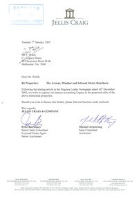
Letter - Document, letter, Sale of properties, 22 Selwood St, Hawthorn East, 9 The Avenue, Windsor, 2003
... decided to sell two of its properties, 22 Selwood St, Hawthorn... from real estate agent, Jellis Craig, Sale of properties, 22 ...Two documents that show that in 2003 Melbourne Legacy decided to sell two of its properties, 22 Selwood St, Hawthorn East and 9 The Avenue, Windsor. This decision was taken due to rising maintenance costs and that the money raised from the sale of the properties could be used to benefit all 24,000 widows under their care. One document was a statement by President Tony Parkes about the decision and the other a letter from Jellis Craig offering to be involved in the sale. They had read about the decision in the Leader newspaper. No time frame had been set and all residents of these two properties would be consulted by Legacy personnel with a family member present. Also photocopies of the two land titles for the properties.This shows the commitment of Melbourne Legacy to ensure that residents individual circumstances, accomodation, needs preferences and location were considered in the move, and cause as little disruption to the residents as possible.Cream A4 paper, plus brochure from real estate agent, Jellis Craig,Stamped 'Received 09 JAN 2003 Melbourne Legacy' in blue ink, top left hand corner. Top centre Jellis Craig letter head. Letter signed Peter Batrouney and Micheal Armstrong (Jellis Craig).widows, properties, titles -
 Melbourne Legacy
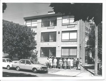
Photograph, Widows' Flats, 1976
A photo of a group of widows outside a block of units in Windsor, that Legacy purchased to provide accomodation for widows. Names unknown but possibly the first tenants to move into the units. From the date stamp is it February 1976. The September 1975 edition of the Legacy Newsletter to Widows, mentions the 20 flats purchased by Legacy at 9 The Avenue, Windsor, and that they are being renovated for widows to live in. Two options were presented, an 'ingoing' amount of $5,000 then a week maintenance charge of $7 a week; or on a rental basis of approximately $20 a week. (a copy of the Title deed shows the flats were purchased on 7 February 1975). Purchase price was $205,000 with the Department of Social Security requiring the addition of lifts to the building (approximate cost $100,000). From President's highlights report in 1981 we know that external blinds were added to the property. The Windsor units were named "Miriam and Frederick James Ramsay Lodge" after a generous donation in 1987. It was decided the Windsor units, and the ones in Hawthorn, would be sold in 2003 and announced by President Tony Parkes. The decision was published in Leader newspapers and Jellis Craig approached Legacy about the sale, see items at 01089.A record of widows being looked after by Legacy by being provided with affordable housing.Black and white photo of Legacy's flats for widows in The Avenue, Windsor.Handwritten 'Legacy Hostel / 9 The Avenue / Windsor' in blue pen. 'Box 11' in black pen. Stamped 'Melbourne Legacy 3 Feb 1976' in purple ink.widows, properties -
 Melbourne Legacy
Photograph, Sale of Harelands renamed Blamey House
From the 1940s Melbourne Legacy ran residences for children of deceased servicemen. In the 1980s it was decided to sell the final property as the requirement for care had dwindled. These photos show the auction day at Blamey House (previously known as Harelands), from the street the auction flag and 'For Sale' sign can be seen. The photos show a large group of people watching the auction names are unknown. The property at 5 Willesmere Rd Kew was formerly known as Harelands. It was renamed Blamey House when the previous Blamey House (at 1267 Burke Road) was sold in late 1970s. It was the third Legacy residence to use the name Blamey House as it was a condition of the donation to keep the name.The sale of Blamey House was a milestone in the residences history and these photos are from the day of the auction.Colour photo x 7 of the auction sale of Blamey House.residences, properties, harelands, blamey house -
 Melbourne Legacy
Photograph, Hibernian Hall, 30/6/1947
A photo of the first property owned by Legacy, at 342 Swanston Street. After receiving money in memory of David H Dureau to purchase premises, Legacy purchased the old Hibernian Hall. However there were many issues with the property, including its suitability and the inability to gain vacant possession from the existing tenants. So eventually the property was sold and the money used to buy the current Legacy House, still formally known as the David H Dureau Memorial Building as per the bequest instructions. The notes on the back of the photo say it was sold to Sir Bernard Evans and then to RMIT and it was renamed Storey Hall. The full story of the donation has been pieced together from several sources. Part of the story of the donation towards Dureau House. BG Corporation in New York used 'Brown and Dureau' as agents in Melbourne for their spark plug manufacturing (for the American aircraft based in Australia during the war). A royalty of two shillings and sixpence was agreed. The entrepreneur President of BG Corporation was Richard Goldsmith. L/ Grat Grattan had a friend Mr Edwards who was managing director at Brown and Dureau and heard of the desire by Mr Goldsmith to leave a permanent memorial to ex-servicemen in Australia (Children's Hospital was considered). L/ Grattan took Mr Edwards to Market St (where Legacy was situated at the time) and showed him the inadequacy of the building. It was agreed if Melbourne Legacy could come up with a purchased building in 10 days they would get the money needed and the building was to be named in memory of David H Dureau, who had died at sea during the war. The donation was £27,059. The property purchased was 'Hibernian Hall' in Swanston St (later called Storey Hall when it was acquired by RMIT). After the war it turned out not to be suitable and a new building was required. An act of parliament was required to enable the sale (01262) and consent from the donor was also sought before the sale (document still to be catalogued). Money raised from the sale was used to purchase 293 Swanston St.A photo of the first property purchased by Legacy as a result of a generous donation.Black and white photo of the old Hibernian Hall in Swanston Street.Handwritten on back 'The old Hibernian Hall purchased by Melbourne Legacy and later sold because of inability to secure vacant possession from tenants. Sold to Sir Bernard Evans then to RMIT and named 'Storey House', in pencil. Stamped '30 Jun 1947' in purple inkproperties, dureau house, swanston st -
 Bacchus Marsh & District Historical Society
Map, Lerderderg Park Lands sale plan. 1911
... for sale from the Lerderderg Park property owned by John Wills... the Lerderderg Park Estate property in 1911. Advertising for the sale ...This plan was for the sale of parcels of land from the Lerderderg Park Estate property in 1911. Advertising for the sale appeared in the Bacchus Marsh Express newspaper through July of 1911. The property was situated only a few kilometers from the township of Bacchus Marsh. The agents for the sale were L. A. Fairbairn & Co.Lerderderg Park Estate was a significant and early colonial property in the Bacchus Marsh area. This plan provides details about the first time the property was subdivided for sale. It is therefore documents an important moment in the history of this property and the broader trend of the subdivision of older and larger properties in the district.A single page paper plan showing allotments of land for sale from the Lerderderg Park property owned by John Wills. The parcels of land for sale are coloured in red.The Lerderderg River and Pyke's Creek Irigation Channel shown on the plan are in blue ink. The rest of the plan is a dark cream or beige colur with the text in black ink. The plan has been extensively annotated with hand-written notes indicating the names of people who purchased the various parcels of lands and the prices paid for those lands. Part of the top of the plan containing some text appears to be missing. The plan is pasted into a bound volume containing 76 maps or plans in total. Top: Have received instructions to Sell, account Mr John Wills, his renowned LERDERDERG PARK LANDS, so well and favourably known throughout the Commonwealth. In areas from 3 acres to 1276 acres. Every lot is either rich lucerne land (or portion now under lucerne) with some higher land adjoining Railway Station, and 2 Milk factories within 2 miles, absolutely the finest land in Victoria. Bottom: THIS IS THE FIRST SUBDIVISIONAL SALE of Rich Flats in Bacchus Marsh since the Pyke's Creek Scheme, and every lot is commanded by it. Only 32 miles from Melbourne.bacchus marsh victoria maps, land sales, lerderderg park estate, land subdivision -
 Warrnambool and District Historical Society Inc.
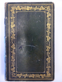
Book, Thalaba the destroyer Vol 1, 1821
... came to us following a clearance sale at the Cassady property... came to us following a clearance sale at the Cassady property ...This book was written in 1801 in an epic poem form. It is unrhymed. It falls into the category of fantasy. The original owner of this book seems to have been John Bland. He is most important in the early history of Port Fairy and had a business in Port Fairy with John Cowtan (corn millers and general merchants). The Cowtans originally had land in the vicinity of the Cassady property of Boughton, Merri River (in Caramut Road near Cassady’s Bridge today) and were related by marriage to the Cassadys. A later owner of the book was William Anderson whose father came to the Yangery district in 1854 and established the property of Rosemount and William remained in this area until his death in 1909. The Andersons were related by marriage to the Cassadys and this book came to us following a clearance sale at the Cassady property, Boughton. This book is of great interest less for its literary content than for its ownership which probably dates back to the 1840s. It is associated with the families of Bland, Cowtan, Cassady and Anderson, all early settlers in Warrnambool and district.This is a brown leather-covered book of 271 pages. The cover has gold decorative borders and patterns and gold lettering. The pages are gilt-edged. The book is the fourth edition of volume one of a Robert Southey poem and has a Preface and Books 1 to 5 with Notes. The inscriptions are handwritten in black ink. One signature has not been deciphered. ‘Wm. Anderson’ ‘John Bland’ william anderson,, rosemount, william cassady, john bland, john cowtan, thalaba the destroyer, warrnambool, poem thalaba the destroyer, 19th century poems, robert southey books -
 Warrnambool and District Historical Society Inc.
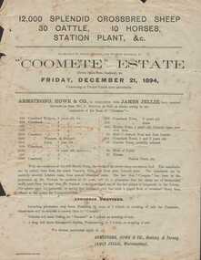
Document - Advertisement, Coomete estate, Sale of stock and plant, 1894
Augustus Bostock was the 9th child of Robert & Rachael Bostock of Vaucluse Epping Forest, Van Diemen’s Land. He was only 4 years old when his mother died. He was inspired by his father to seek his fortune in the Western District of Victoria. He arrived around 1850. He married Margaret Aitkin in July 1865. Augustus owned several properties in the district and leased others. He sat on the court of Warrnambool, Mortlake or Hexham as required. He resided at Marramook in Hawkesdale and later moved to Vaucluse in Hopetoun Road Warrnambool, where he died in 1920 at the age of 87. He was involved in many aspects of life in the Western District, racing, cricket, and social activities to name a few. This flyer is advertising the sale of 12000 sheep, 30 cattle, 10 horses and station plant at the expiration of the lease of Coomete. It states that Coomete has been in the possession of Mr. Augustus Bostock for over 30 yearsThis is one of a number of documents which relate to the Bostock family who were one of the most important pioneering families of the Western District. They owned and leased various properties around Warrnambool and were involved in many aspects of social and business life. This document contains a detailed view of the stock owned by Augustus Bostock at Coomete. From a social perspective the details provided show that it was an event of some importance in the farming area.Cream paper with heading and title in large font at the top with Coomete Estate in uppercase inside banner lines underneath with details of stock and numbers to be sold in smaller print below. Mercer printer Geelong. For further particulars apply to Armstrong, Howe & Co Geelong and Terang, James Jellie Warrnambool.coomete, warrnambool, augustus bostock, coomete lease, 1894 -
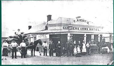 Wodonga & District Historical Society Inc
Photograph - The Carriers' Arms, Wodonga
In October 1874, Thomas Reidy and Andrew McCormack opened the Carriers’ Arms on the corner of South and Church Streets. They also established a general store next door, which they soon extended. The Carriers’ Arms was a coach stop for the Bethanga Express Coach. On 8 December 1882 the licence for the Carriers’ Arms was granted to Ann Reidy. In 1883, Edmund T. Powell, and his Irish-born wife, Mary Ann, purchased the Carriers’ Arms. By 1898 the Licence was in the name of M. A. Powell. She was still the licensee at the time of her death in August 1906. For a short time, the property was in the hands of Miss Maud Powell but in February 1907, the licence for The Carriers’ Arms Hotel was transferred to Mr George L. Leighton. On Monday 5th February 1917 a clearing sale of all furniture and effects of the Carriers’ Arms Hotel was held. The new proprietor and licensee was Henry R. Baker. In April 1920, the Carriers’ Arms had another new proprietor, Mrs A. E. Frauenfelder but by October 1921 it was transferred to Kathleen Hickey. Mrs. Hickey was at the Carriers’ Arms until she died in January 1926. In 1927, Mr H.W. Allen, formerly proprietor of the Terminus Hotel took over the Carriers’ Arms but in August 1928 the balance of the lease was transferred to Mrs Mulrooney. In 1932 it again changed hands, with the licence being transferred to Mrs Eileen Dorothy Hemphill, of Wodonga. In 1933 the Carriers’ Arms was licensed to Mrs. M.G. O’Brien, a sister of Mrs Hemphill. In 1935 Leo Houlihan took over the business but 6 months later it was transferred to A C Ferguson. The next year the licence was transferred yet again to Zelda Allen. By 1937 it was in the hands of Percy Cumberland then to Lila Maud MacPherson and soon followed by Ronald Dobson. By 1940 Herbert V.A. Callender had taken over the Carriers’ Arms and in 1942 the licence was transferred again to Sarah Jane Callander. In July 1943 Mr G. A. Adams disposed of the freehold of the Carriers’ Arms Hotel in Hume Street to Mr J.H. Perry. By September 1955 Edward Spencer held the Victualler’s licence for Carriers Arms Hotel and the licences was transferred to Kevin Patrick Howell. Mr Howell operated the hotel for many years. At some stage in the 1980s Geoff Milne operated the Carriers’ Arms. In 2007 he was killed in a light airplane crash. In 1991 David McLeish and Bob Craig, took over the Carriers’ Arms and were joined in 1993 by James Carroll. They continued to operate it until 2003. In 2010 Greg Evans held the Freehold with Licensees Cate Nightingale and Michael McNamara, After running into major financial difficulties it was run by Greg Evans. In 2010 the Carriers’ Arms was put up for auction but failed to sell. From 2013 - 2016, Ron Montgomery and his wife Michelle took over the lease of the Carriers’ Arms. In 2018, the Carriers’ Arms was purchased from Greg Evans by Leigh Esler. After opening to the public in 1874, The Carriers’ Arms was closed in 2019 and following extensive refurbishment opened as Church Street These items are significant as they document the history of a long-serving business in the Wodonga community.A collection of photos and advertisements documenting the life of the Carriers' Arms Hotel, Wodonga.early wodonga businesses, carriers' arms wodonga -
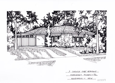 Whitehorse Historical Society Inc.
Artwork, other - Ink Line Drawing, Margaret Picken, 3 Coringa Close., Vermont South, 1992
... A property illustration by Margret Picken Commissioned...A property illustration by Margret Picken Commissioned ...A property illustration by Margret Picken Commissioned by a real estate agency for the purpose of advertising 3 Coringa Close., Vermont South Although drawn for sale in 1992, this property is listed as having sold for $98,000 in 1996 Made by using Rotring ‘Rapidigraph’ drafting pens with Rotring ink on Rapidigraph polyester drafting film, double matte. Trained as a cartographic draftsman within the mining industry, Margaret Picken is an artist who worked producing property illustrations for real estate agencies in eastern suburbs of Victoria from 1983-2005. Retiring from the industry as technological changes favored coloured photography over illustrations, and commissioning companies over sole contractors.This artwork is of Historical Significance as a record of local domestic architecture.A black ink line drawing on drafters film by Margaret Picken, of a black and white line drawing of a single story brick house. To the left is a driveway leading to a gated carport, connected to the house. In the foreground is a front lawn either side of the driveway, with garden beds in front of the house. There are two hole punch holes just below centre of the upper edge3 Coringa Close., Vermont South Margaret Picken - 92 Woodards - Kewwhitehorse historical society, schwerkolt cottage, housing, architecture, margaret picken, house, garden, real estate, vermont, vermont south -
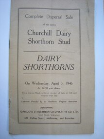 Churchill Island Heritage Farm
Document - Sales booklet, April 3, 1946
The Churchill Dairy Shorthorn Stud was owned by Dr Harry Jenkins during his private ownership of Churchill Island, who also bred and managed the livestock for sale within this document. The sale concludes Jenkin's breeding program and turns another chapter of ownership of the Island - this sale took place on Mr Cleeland's property (6 miles from the Anderson Railway Station) who was another significant memebr of the community during this time.Small bound document featuring sales information on plain blue front cover.Complete Dispersal Sale/of the entire/Churchill Dairy Shorthorn Stud/DAIRY SHORTHORNS/On Wednesday, April 3, 1946/At 12.30 p.m. sharp./Train leaves Flinders Street on day of sale at 8.20 and/returns same day./Luncheon Provided by the Newhaven Progress Association/Auctioneers/GIPPSLAND & NORTHERN CO-OPERATIVE CO. LTD.,/Stud Sock Salesmen,/623 Collins Street, Melbourne and Branches.churchill island, farming history, dairy shorthorns, dairy farming, harry jenkins, john cleeland -
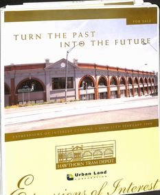 Melbourne Tram Museum
Document - Folder with papers, Urban Land corporation, "Hawthorn Tram Depot - Expressions of Interest Documentation", late 1998
... Trams tramways HTT Hawthorn Tram Depot Sale Of Land Property ...White two spring clip folder with papers, titled "Hawthorn Tram Depot - Expressions of Interest Documentation", sub-titled "Turn the Past into the Future" Has a photo of Hawthorn Tram depot and an image on the front cover. Closing date 17/2/1999, prepared by the Urban Land Corporation with the assistance of VicTrack. Approx 110 pages with supplementary papers in the end covers. Contains a table of contents, checklist, EOI Process, Development Brief, Site conditions. Gives details of the heritage registration, site plans, building plans, property title and detailed room condition and use of the ground floor. Supplementary papers include the marketing brochure, letters and a detail feature and level survey by Bosco Johnson surveyors, 30-9-1998.trams, tramways, htt, hawthorn tram depot, sale of land, property -
 Melbourne Tram Museum
Magazine, Paul Edwards, "The House that Trams built...", c1980
... for notes on the sale of the property.... for notes on the sale of the property. "The House that Trams built ...Centre page spread of an article titled "The House that Trams built...", from the Australasian Post - undated - c1990, full colour, about the two ex Melbourne trams that Rolf Herweg used to build a house at Ferny Creek, tramcars No. 1 and 6. Gives details of the person, costs, and that he wishes to sell the house and move on. Written by Paul Edwards with photos by Barry Weller. See also Reg Item 1518 for another newspaper cutting and 1833 of the tram in MMTB service. See Reg Item 4657 for notes on the sale of the property.trams, tramways, ferny creek, tramcars, pmtt, melbourne, houses, tram 1, tram 6 -
 Melbourne Tram Museum
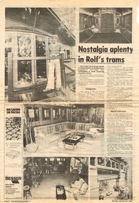
Newspaper, The Mounteasterly, "Nostalgia aplenty in Rolf's trams", 30/01/1984 12:00:00 AM
... ". Advises of the sale of Rolf Herweg's home made from old tramcars...". Advises of the sale of Rolf Herweg's home made from old tramcars ...Newspaper clipping from The Mounteasterly, Monday Jan 30, 1984 with an article titled "Nostalgia aplenty in Rolf's trams". Advises of the sale of Rolf Herweg's home made from old tramcars in School Road Ferny Creek, details of the houses, tramcars and contact numbers. Has five photos which shows the number on one of the trams to be "6". See also Reg Item 1356 for another newspaper cutting which identifies the other tram as No. 1. Reg item 1833 has a photo of No. 1 in MMTB service with a note about it being a dining room. See Reg Item 4657 for notes on the sale of the property in 1983.trams, tramways, ferny creek, tramcars, pmtt, melbourne, houses, tram 1, tram 6 -
 Melbourne Tram Museum
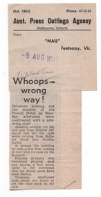
Newspaper, Mail Footscray, "Whoops - wrong way", 5/08/1981 12:00:00 AM
... subsequent sale to a Lilydale property, though this may... subsequent sale to a Lilydale property, though this may ...Newspaper cutting from the Mail Footscray about W2 227 derailing while turning from Ballarat Road into Gordon St and heading towards the Power Hotel on the Monday (3/8/1981) afternoon. Titled "Whoops - wrong way" See also Reg item 1639 for its subsequent sale to a Lilydale property, though this may not be correct - a check with the tramcar card shows that it was withdrawn and sold during July 1981 and that Z3 227 did not enter service until 1984. Cuttings has the Aust. Press Cuttings Agency source sheet pasted to the top right hand corner along with the paper name and date stamp.Has in pencil at top of cutting "MT/Ballarat Trams"trams, tramways, accidents, mmtb, footscray, ballarat rd, gordon st, w2 class, tram 227 -
 Melbourne Tram Museum
Document - Personal Papers, The Age, Keith Kings, Progress Press, Higgins Teale & Co, Herald Sun, house built using former PMTT tramcars, 1976 to 1983
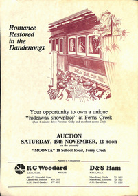
Collection of Personal Papers regarding a house built using former PMTT tramcars. Comprises: 1 - Auction notice - folded A3 light card, "Moonta 18 School Road Ferny Creek" - giving details of the property, agents, floor plan and auction date of 19/11/1983. Agents R. Woodard and D&S Ham (2 copies held) 2 - Newspaper clipping from the Progress Press with a sketch and article - "Home built from trams" 3 -"Fares please for tram treat" - Herald Sun, 24/9/1983. 4 -Auction notice - 21/11/1983 - property passed in. 5 - hand written note, with plan of the trams and location map - not dated 6 - set of six hand written notes recording conversations with various people regarding a house in Ferny Creek with trams, including the Public Trustee 1976 and 1977. 7 - Auction notice for "Charrawalla" - School Road, Ferny Creek dated 7/5/1977 from The Age. Not all items numbered, See also Reg Item 1356, 1833 and 1518 for related items.trams, tramways, mmtb, pmtt, ferny creek, tramcars, melbourne, houses, sale of land -
 Melbourne Tram Museum
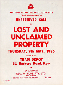
Poster, Metropolitan Transit Authority (MTA), "Unreserved Sale of Lost and Unclaimed Property - Thursday 9th May 1985", May. 1985
... "Unreserved Sale of Lost and Unclaimed Property - Thursday...Poster - printed on paper, titled "Reserved Sale of Lost... Trams tramways Lost Property Auctions Posters Kew Depot Poster ...Poster - printed on paper, titled "Reserved Sale of Lost and Unclaimed Property - Thursday 9th May 1985" at Kew Depot from 10am. Notes an available catalogue from Geo M Hume Pty Ltd. Issued by The Met or Metropolitan Transit Authority Dated May 1985trams, tramways, lost property, auctions, posters, kew depot -
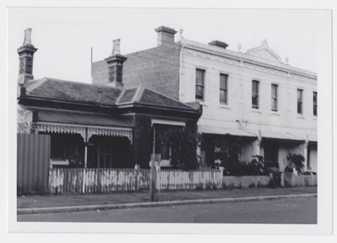 Port Melbourne Historical & Preservation Society
Photograph - Properties in Stokes Street, Port Melbourne, 1976 - 2012
Photographic images of properties in Port Melbourne. Image may have been taken by a PMHPS member or scanned from a past resident or taken for real estate sale purposes. Stokes St numbers: 20; 22; 24; 26 (1976); 106; 108 (2012); 122; 124 (approx 2000)built environment - domestic, stokes street