Showing 774 items matching "proposed plans"
-
 Eltham District Historical Society Inc
Photograph, Russell Yeoman, Fitzsimons Lane Bridge over Yarra River between Eltham and Templestowe, c.1970, 1970c
... plans that showed proposed land acquisition for the future... plans that showed proposed land acquisition for the future ...The bridge over the Yarra River was initially opened September 22nd, 1961. Newspaper reports at the time of opening stated it linked Bolton Street, Eltham, with Fitzsimons Lane, Templestowe. In 1955 the Country Roads Board (CRB) produced survey plans that showed proposed land acquisition for the future bridge and road approaches. The 1955 plan shows that it was proposed to connect Fitzsimons Lane with Bolton Street in Eltham by a diagonal road across the river. The road connection would then continue along Bolton Street to Main Road. Prior to construction of the bridge the CRB modified the proposal significantly so that there was a new road parallel with Bolton Street and then curving to join Main Road at what was then its intersection with Old Eltham Road. This involved significantly more land acquisition and altered the pattern of land subdivision through this corridor. Initially the new road was just a single two-way carriageway as it would have required a significant widening of the cutting on the Shire of Eltham side of the river. The road was officially un-named but was known locally as the Eltham-Templestowe Road. The 1966 Melway street directory and other 1960s editions also listed the road as the Eltham-Templestowe Road. In December 1970, Eltham Shire Council, in pursuance of the provisions of the Local Government Act, named it Templestowe Road. The road was renamed Fitzsimons Lane around 1984 in conformity with the section south of the river. In 1991 a new bridge was built to the west of the original bridge. Fitzsimons Lane was widened to four traffic lanes although on the Eltham side this was done within the limits of the existing cutting. NEW BRIDGE STARTS THEM EXPLORING Without any fanfares, Country Roads Board workmen on Friday afternoon put the finishing touches to the approaches, removed the barricades, and let the traffic roll over the new Yarra bridge linking Bolton Street, Eltham, with Fitzsimons Lane, Templestowe. Over the week-end many “bridge watchers” who were making one of their periodic inspections of the progress on the new bridge found to their surprise that they could drive over it, so that people who had gone for a run out to Eltham suddenly found themselves wandering through Templestowe and Doncaster. By Monday the word of the bridge’s opening had got around sufficiently for many regular travellers to the city from Eltham and beyond to vary the monotony by going to town via Templestowe and Kew instead of through Heidelberg. They were surprised at the distances – about 3 ½ miles from Eltham to Templestowe, 6 miles from Eltham Shire hall to the Lower Heidelberg Road-Banksia Street intersection. NEW NEIGHBOURS For people on both sides of the river, the new bridge has turned distant friends into near neighbours. A Greensborough man on Sunday took 35 minutes to reach the home of a friend in East Doncaster, but the return trip over the new bridge took only 17 minutes. It will be some time yet before most people work out the possibilities in shorter and quicker trips form the north-eastern areas to the eastern and south-eastern suburbs. The coming of the warmer months will soon teach many, though the short cuts to Peninsular beaches and eastern suburban drive-ins. And before very long it is likely there will be a Tramways bus running from Templestowe to Eltham station. NEW BRIDGE STARTS THEM EXPLORING (1961, September 27). The Diamond Valley News (News clipping held in SEA_74-1_047) The previously un-named road between Main Road and Yarra River, Eltham South, east of Bolton Street was named Templestowe Road, December 15, 1970 NAMING OF STREETS AND ROADS. (1970, December 15). The Diamond Valley News (News clipping held in SEA_74-2_022)Roll of 35mm black and white negative film, 4 of 7 stripsIlford HP4bridge, bridges, fitzsimons lane bridge, infrastructure, shire of eltham infrastructure, yarra river -
 Eltham District Historical Society Inc
Photograph, Fitzsimons Lane Bridge over Yarra River between Eltham and Templestowe, c.1966, 1966c
... plans that showed proposed land acquisition for the future... plans that showed proposed land acquisition for the future ...The bridge over the Yarra River was initially opened September 22nd, 1961. Newspaper reports at the time of opening stated it linked Bolton Street, Eltham, with Fitzsimons Lane, Templestowe. In 1955 the Country Roads Board (CRB) produced survey plans that showed proposed land acquisition for the future bridge and road approaches. The 1955 plan shows that it was proposed to connect Fitzsimons Lane with Bolton Street in Eltham by a diagonal road across the river. The road connection would then continue along Bolton Street to Main Road. Prior to construction of the bridge the CRB modified the proposal significantly so that there was a new road parallel with Bolton Street and then curving to join Main Road at what was then its intersection with Old Eltham Road. This involved significantly more land acquisition and altered the pattern of land subdivision through this corridor. Initially the new road was just a single two-way carriageway as it would have required a significant widening of the cutting on the Shire of Eltham side of the river. The road was officially un-named but was known locally as the Eltham-Templestowe Road. The 1966 Melway street directory and other 1960s editions also listed the road as the Eltham-Templestowe Road. In December 1970, Eltham Shire Council, in pursuance of the provisions of the Local Government Act, named it Templestowe Road. The road was renamed Fitzsimons Lane around 1984 in conformity with the section south of the river. In 1991 a new bridge was built to the west of the original bridge. Fitzsimons Lane was widened to four traffic lanes although on the Eltham side this was done within the limits of the existing cutting. NEW BRIDGE STARTS THEM EXPLORING Without any fanfares, Country Roads Board workmen on Friday afternoon put the finishing touches to the approaches, removed the barricades, and let the traffic roll over the new Yarra bridge linking Bolton Street, Eltham, with Fitzsimons Lane, Templestowe. Over the week-end many “bridge watchers” who were making one of their periodic inspections of the progress on the new bridge found to their surprise that they could drive over it, so that people who had gone for a run out to Eltham suddenly found themselves wandering through Templestowe and Doncaster. By Monday the word of the bridge’s opening had got around sufficiently for many regular travellers to the city from Eltham and beyond to vary the monotony by going to town via Templestowe and Kew instead of through Heidelberg. They were surprised at the distances – about 3 ½ miles from Eltham to Templestowe, 6 miles from Eltham Shire hall to the Lower Heidelberg Road-Banksia Street intersection. NEW NEIGHBOURS For people on both sides of the river, the new bridge has turned distant friends into near neighbours. A Greensborough man on Sunday took 35 minutes to reach the home of a friend in East Doncaster, but the return trip over the new bridge took only 17 minutes. It will be some time yet before most people work out the possibilities in shorter and quicker trips form the north-eastern areas to the eastern and south-eastern suburbs. The coming of the warmer months will soon teach many, though the short cuts to Peninsular beaches and eastern suburban drive-ins. And before very long it is likely there will be a Tramways bus running from Templestowe to Eltham station. NEW BRIDGE STARTS THEM EXPLORING (1961, September 27). The Diamond Valley News (News clipping held in SEA_74-1_047) The previously un-named road between Main Road and Yarra River, Eltham South, east of Bolton Street was named Templestowe Road, December 15, 1970 NAMING OF STREETS AND ROADS. (1970, December 15). The Diamond Valley News (News clipping held in SEA_74-2_022)Black and white photographManufacturer's marks: Polaroid, Batch #J62K181 (Sep 1966).infrastructure, shire of eltham infrastructure, bridge, fitzsimons lane bridge, polaroid, yarra river -
 Eltham District Historical Society Inc
Photograph, Fitzsimons Lane Bridge over Yarra River between Eltham and Templestowe
... plans that showed proposed land acquisition for the future... plans that showed proposed land acquisition for the future ...The bridge over the Yarra River was initially opened September 22nd, 1961. Newspaper reports at the time of opening stated it linked Bolton Street, Eltham, with Fitzsimons Lane, Templestowe. In 1955 the Country Roads Board (CRB) produced survey plans that showed proposed land acquisition for the future bridge and road approaches. The 1955 plan shows that it was proposed to connect Fitzsimons Lane with Bolton Street in Eltham by a diagonal road across the river. The road connection would then continue along Bolton Street to Main Road. Prior to construction of the bridge the CRB modified the proposal significantly so that there was a new road parallel with Bolton Street and then curving to join Main Road at what was then its intersection with Old Eltham Road. This involved significantly more land acquisition and altered the pattern of land subdivision through this corridor. Initially the new road was just a single two-way carriageway as it would have required a significant widening of the cutting on the Shire of Eltham side of the river. The road was officially un-named but was known locally as the Eltham-Templestowe Road. The 1966 Melway street directory and other 1960s editions also listed the road as the Eltham-Templestowe Road. In December 1970, Eltham Shire Council, in pursuance of the provisions of the Local Government Act, named it Templestowe Road. The road was renamed Fitzsimons Lane around 1984 in conformity with the section south of the river. In 1991 a new bridge was built to the west of the original bridge. Fitzsimons Lane was widened to four traffic lanes although on the Eltham side this was done within the limits of the existing cutting. NEW BRIDGE STARTS THEM EXPLORING Without any fanfares, Country Roads Board workmen on Friday afternoon put the finishing touches to the approaches, removed the barricades, and let the traffic roll over the new Yarra bridge linking Bolton Street, Eltham, with Fitzsimons Lane, Templestowe. Over the week-end many “bridge watchers” who were making one of their periodic inspections of the progress on the new bridge found to their surprise that they could drive over it, so that people who had gone for a run out to Eltham suddenly found themselves wandering through Templestowe and Doncaster. By Monday the word of the bridge’s opening had got around sufficiently for many regular travellers to the city from Eltham and beyond to vary the monotony by going to town via Templestowe and Kew instead of through Heidelberg. They were surprised at the distances – about 3 ½ miles from Eltham to Templestowe, 6 miles from Eltham Shire hall to the Lower Heidelberg Road-Banksia Street intersection. NEW NEIGHBOURS For people on both sides of the river, the new bridge has turned distant friends into near neighbours. A Greensborough man on Sunday took 35 minutes to reach the home of a friend in East Doncaster, but the return trip over the new bridge took only 17 minutes. It will be some time yet before most people work out the possibilities in shorter and quicker trips form the north-eastern areas to the eastern and south-eastern suburbs. The coming of the warmer months will soon teach many, though the short cuts to Peninsular beaches and eastern suburban drive-ins. And before very long it is likely there will be a Tramways bus running from Templestowe to Eltham station. NEW BRIDGE STARTS THEM EXPLORING (1961, September 27). The Diamond Valley News (News clipping held in SEA_74-1_047) The previously un-named road between Main Road and Yarra River, Eltham South, east of Bolton Street was named Templestowe Road, December 15, 1970 NAMING OF STREETS AND ROADS. (1970, December 15). The Diamond Valley News (News clipping held in SEA_74-2_022)Black and white photographinfrastructure, shire of eltham infrastructure, bridge, fitzsimons lane bridge, yarra river -
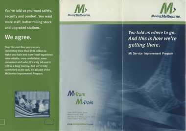 Melbourne Tram Museum
Pamphlet - Set of 2, M>Tram, "Moving Melbourne - You told us where to go. And this is how we're getting there", c2001
1 - Folded pamphlet titled "Moving Melbourne - You told us where to go. And this is how we're getting there", published by National Express Transport, the operators of M>Tram, (Swanston Trams) and M>Trains (Bayside Trains) prior to their demise, under the banner of Moving Melbourne. Provides details of the M> service improvement program and dates proposed - Feb. 2001 and Early 2003. The company operated from 2001 to April 2004 when the trams taken over by Yarra Trams and trains by Connex. 2 - Thanks Melbourne you told us where to go - reporting on feedback received from customers, and provides dates for improvements from Jan 2001 to late 2002.Yields information about National Express planning for Melbourne public transport.Pamphlet 3 fold DL, full colour and 2 fold DL pamphlet.trams, tramways, swanston trams, bayside trains, m>tram, m>train -
 Lakes Entrance Historical Society
Book, Dept of Natural Resources and Environment Victoria Publisher, Heritage Rivers and Natural Catchment Areas Vol 3, 1997
Draft Management Plans prepared under the Heritage Rivers Act set out the proposed basis for future management of Heritage Rivers and Natural Catchment Areas. Gippsland catchments are significant for the essential undisturbed conditionISBN 0730667936environment, waterways -
 Eltham District Historical Society Inc
Audio - Audio Recording, Audio Recording; 2018-10-13 Eltham Community Town Hall Meeting, 13 Oct 2018
Meeting to discuss the Nillumbik Shire Council's proposed sale and devlopment of the former Shire Office site at 895 Main Road as well as the Eltham War Memorial including the Maternal and Infant Welfare Centre, Eltham Pre-school and Eltham War Memorial Hall and Memorial Gardens at 903-907 Main Road which also includes thje Eltham Senior Citizen's Centre. The meeting was attended by more than 300 people which considered the following: Motion from public meeting – Saturday 13th October, 2018 1. This meeting has no confidence in Nillumbik Shire Council's proposed process for the re-development of 895 and 903-907 Main Rd, Eltham and we deplore the cursory attention given to public consultation to date. 2. We call on Council: *to preserve the Eltham War Memorial building complex at 903-907 Main Rd, Eltham, and retain their existing uses in accordance with the Eltham War Memorial Trust purpose; and retain the Cenotaph and Eltham Senior Citizens' Centre. * to retain council ownership of all land at 895 and 903-907 Main Rd, Eltham for our community and future generations. * following meaningful engagement with residents of the Shire, to place sufficient planning controls on the site of the former Eltham Shire Office to ensure that any future development of that land responds to Eltham's form and character and properly protects public amenity, access and use. * to make all proposals for the development of 895 and 903-907 Main Rd, Eltham available for public inspection as soon as they are received by Council. Moved: Greg Johnson Seconder: Andrew Lemon * carried unanimously1:28:52 duration Digital MP3 File 30.5 MB 895 main road, 903-907 main road, community meeting, eltham pre-school, eltham shire office, eltham war memorial, eltham war memorial hall, infant welfare centre, nillumbik shire council, senior citizen's centre -
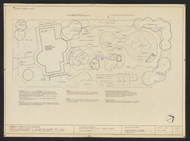 University of Melbourne, Burnley Campus Archives
Plan, Steve Mullany, Energy Education Centre, 1988
(1) Tracing paper and paper plans, Preliminary Landscape Plan by Steve Mullany, Lecturer Amenity Horticulture Dept. V.C.A.H. Burnley, Sheet 1 of 1 May 2, 1988. (2) 1 tracing paper and 2 paper copies State Schools' Nursery: Proposed Landscape Working Drawing Energy Education Centre Burnley by E.A.H. June 1988. (3) 2 copies State Schools' Nursery: Proposed Landscape Working Drawing Energy Education Centre Burnley, by EAH 18 June 1988 (Details). (4) 2 copies as (3) Pond Plans & Details 16 June 1988. (5.) Designs for small plans of above.vcah, steve mullany, state schools nursery, landscape design, energy education centre burnley -
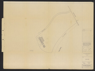 University of Melbourne, Burnley Campus Archives
Plan, Alexander Metherell, Library - Boulevard/Engineering Block, 1983
(1) Site Plan by Alexander Metherell Pty. Ltd. Job No BHC/1 Drawing No SP/3 dated Dec 1983. On reverse, Plan SP/3 Library - Boulevard." (2) 4 tracing paper copies with various annotations. (3) Tracing paper planting plan. (4) Coloured, laminated copy, Proposed Planting: Engineering Block and 2 sketches on tracing paper and paper. Also see B15.0352 for Full Report.alexander metherell, library -
Stawell Historical Society Inc
Archive - Drawings, St Matthews Uniting Church Plans, 20/4/1977
Sheet 1 - Line drawing of suggested ideas for interior of St Matthews Presbytery 20/4/1977 Sheet 1A - Organ at South end bet set on ceiling of Narthex set back against wall 20/4/1977 Sheet 1B - Organ at South end but set lower into front wall of glass screen of Narthex 20/4/1977 Sheel 1C - Organ at South end set overhanging front screen of Narthex Screen 20/4/1977 Sheet 2 - Proposed Glorious Cross in Metal, Lead, Glass 20/4/1977Paper in brown cardboard Roll Holderreligion -
Stawell Historical Society Inc
Archive - Blueprint, St Matthew Uniting Church Plans, 12/10/1997
Proposed alterations to Uniting Church St Matthews Stawell N.H. Cottman 12/10/1979Paper & Tracing Paper in brown Cardboard roll holderreligion -
 University of Melbourne, Burnley Campus Archives
Plan, Student Amenity Building (Citriodora) Courtyard, 1988-2000
Various plans for what is now known as the "Citriodora Courtyard." I copy tracing paper, 1 coloured original, 4 copies with additional notation 6 smaller copies with additional notation. (1) Planting Plan Plant Science Area V.C.A.H. Burnley designed by J. Hitchmough, drawn by S. Mullany 3 October 1988. (2) Student Amenity Quad Sketch Proposal by M. Green May '95. (3) Rough pencil design, New Design related to Horticultural pursuits of Burnley College. (4) Coloured, Proposed Citriodora Court Redevelopment. (5) 2 copies Citriodora Courtyard Presentation Concept Plan by Adrian Bonifacio. November 2000. (6) Landscape Graphics II Assoc. Diploma in Horticulture (Amenity) Assignment 2 - Planting Plan May 1988. (7) Laminated, Preliminary Plan 2 of 4 Citriodora Lawn Burnley by Kate Szmal B.A.S.H. (8) Laminated, Preliminary Plan Student Amenity Building Courtyard V.C.A.H. Burnley by Caroline Lodge. (9) 1 tracing paper and 1 paper copy University of Melbourne Burnley College Student Amenity Building Courtyard 19.8.99. (10) Setout Plan, Planting Plan & Surface Finishes, Details Courtyard & Entrance, ACM Landscape Architecture: Concrete Paving Topsoil, Mulch - notes. "Phil Tulk," handwritten on reverse. (11) Laminated, V.C.A.H. Preliminary Plan p3 of 5 Project No 1 Student Amenity Building Courtyard by K. Watson 15-8-95. (12) Citriodora Courtyard Redevelopment Concept Plan by Judy Brookes November 2000. 2 copies of Drawing 1 of 2, 1 copy Drawing 2 of 2. (13) Proposed Outdoor Eating Area Student Amenities Block: Scheme 1 pp 2-5 of 5, 16.10.96. Scheme 2 pp 3-5 of 5, 16.10.96. Scheme 8 3 copies p1 of 2, 2 copies p2 of 2, 23.6.97, Paving Types p1 of 1, 30.9.99, handwritten on reverse,"to Phil from Nicki." (14) 2 copies Entry from Rear Car Park Paving Plan. (15) Plan by Margaret Kitching 8.8.90. citriodora courtyard, vcah, centenary courtyard, plant science area, k. watson, s. mullaney, j. hitchmough, judy brookes, kate szmal -
 Whitehorse Historical Society Inc.
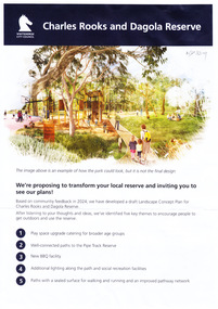
Document, Charles Rooks and Dagola Reserve, 19/03/2025
The Whitehorse City Council is proposing to transform the Charles Rooks and Dagola Reserve and is inviting residents to view plans and comment by 17/03/2025non-fictionThe Whitehorse City Council is proposing to transform the Charles Rooks and Dagola Reserve and is inviting residents to view plans and comment by 17/03/2025dagola avenue nunawading, charles rooks and dagola reserve, pipe line reserve, parks and reserves, lorikeet avenue nunawading -
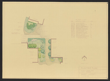
University of Melbourne, Burnley Campus Archives
Plan, Phil Tulk, Proposed Planting Scheme Nursery Surrounds, 1997
Coloured plan by Phil Tulk 5/8/97.phil tulk, nurseries, kunzea, dianella -
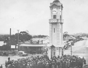 Ringwood and District Historical Society
Photograph, Opening of clock tower by Mayor W. Mackinlay in August 1928
Age (Melbourne, Vic. : 1854 - 1954), Monday 6 August 1928, page 9 ________________________________________ RINGWOOD WAR MEMORIAL CLOCK TOWER UNVEILED A CIVIC CEREMONY. The people of Ringwood have erected a beautiful stone clock tower at a cost of £1797, as a memorial to those who served in the war. The unveiling ceremony was performed by the mayor of Ringwood (Cr. W. Mackinlay) on Saturday. “Bleak conditions with showers intervening prevailed at Ringwood on Saturday afternoon, when the unveiling ceremony of the soldiers' memorial clock tower, performed by the mayor (Cr. W. Mackinlay) took place in the presence of a Iarge and representative gathering. The ceremony was solely a civic one. A majority of members of the local branch of the R.S.S.I.L.A. had wished that Sir John Monash be invited to take a prominent part in the proceedings, but the trustees elected otherwise. The Salvation Army band from Box Hill rendered suitable music, while Sergeant E. P. Taylor (37th Battalion, A.I.F) sounded the Reveille and The Last Post impressively. Among those present were Mr. Edgar, M.L.C., the vicar of Ringwood (Rev. E. E. Robinson), Rev. G. McLaren (Methodist), the memorial trustees (Cr. J. B. McAlpin, Messrs, J. W. Barrett, A. H. Locke, J. A. Williams and A. G. Ashley). The last two mentioned are president and honorary secretary respectively of the local branch of the R.S.A. Soldier delegates from Camberwell and Mitcham were also present. At the outset the mayor said a few words would not be amiss concerning why the memorial had been so long delayed in being erected. In September, 1919, a public committee was formed, with Mr. A. V. Greenwood as chairman, to consider the erection of a suitable memorial to the soldiers. Among the more important suggestions had been the building of a hall and clubrooms on land generously offered by Mr. R. W. Dawes. This project had been abandoned, also the proposed erection of a huge memorial building, at a cost of £5000, on the site of the present town hall. As two years had passed without anything of a definite nature eventuating it was decided to elect five trustees, comprising three citizens and the president and secretary of the Returned Soldiers' Association with full power to act. In all propositions the trustees had been faced with financial difficulties, but about the time of the completion of the plans of the memorial tower Ringwood became a borough, and the new council was appealed to, and provided £500 to make the erection of the memorial possible. The architect, (Mr. H. Norris) had refused to take anything beyond out-of-pocket expenses (£16), while the engineer (Mr. Lucas) had saved a goodly sum by supervising the work. The total funds at the disposal of the trustees, including the council's donation, was, in round figures £1807. The tower complete would cost £1690; honor roll, £77, and fees paid for various designs had amounted to £30. The total expenditure was £1797, leaving a credit balance of £10. Before the unveiling the mayor, in again addressing the citizens, said he deemed it a privilege to perform such a task in connection with so splendid a memorial. The citizens had erected it as an expression of heartfelt gratitude in memory, first of all, of those heroes who gave not only their services, but their lives, when the call came in the common cause of right and liberty, upon which the British Empire was built. This memorial was also the tribute of the citizens in a degree of appreciation to those men who so un-selfishly and ungrudgingly volunteered their services in the Great War. The memorial, while commemorating the glorious deeds of Australian manhood, was not intended, in any sense, as a glorification of war. The memorial would tend to bring to one's mind the blessing of peace in contrast to the curse of hostilities. They were gathered there that afternoon to do honor to all those who volunteered for service to the Great War, but they wished to assure the friends and relatives of those who paid the supreme sacrifice of their sincere sympathy and trust. If ever in the future this fair southern land of ours was threatened by an invader he felt sure that Australian manhood would not hesitate to rally to the call to duty and defend the freedom of their country. Following prayer by Rev. G. McLaren (Methodist), the memorial clock tower was unveiled, the acting mayoress (Mrs. Mackinlay) cutting the cord, after which the making over of the memorial to the borough council took place, the president of the local branch of the R.S.A. (Mr. J. A. Williams) stating he had pleasure in accepting the key on behalf of the trustees. As the council was the permanent governing body the key would be handed back to the mayor, the memorial being given into the safety and custody of the council. During the proceedings the hymns O God, Our Help in Ages Past and Lest We Forget were rendered, the choirs of various denominations joining in the singing. Benediction was pronounced by the vicar of Ringwood (Rev. E. E. Robinson).” Black and white photograph (2 copies- one original mounted on cardboard backing)Written on rear of backing of original: "Opening of clock tower by Mayor W. Mackinlay, 4.8.1928." Written on back of copy" "Mayor Mackinlay dedicating Ringwood clocktower in original position at end of Warrandyte Rd. 1928. Maroondah Hwy on right." -
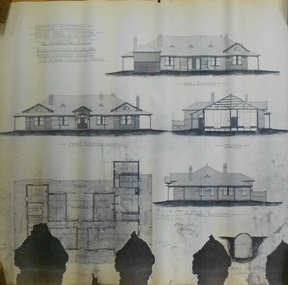 Bendigo Historical Society Inc.
Plan - MARKS COLLECTION: PLAN ALBERT PARK SERPENTINE FOR G. LANSELL
Copy of plan written on top LH corner: Proposed Homestead Albert Park Serpentine for H. Lansell Esq. Scale eight feet to one inch. W. Beebe & G.D. Garvin Architects, late W. Beebe, Mitchell St. Bendigo. Plan shows front, back and side elevation with floor plan for residence.buildings, house, albert park serpentine -
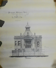 Bendigo Historical Society Inc.
Document - MARKS COLLECTION: PLAN OF FORTUNA VILLA ENTRANCE HALL
... Copy of plan: Written on top: Proposed Entrance Hall...: Proposed Entrance Hall, Fortuna Villa, for G. Lansell, Esq. Plan ...Copy of plan: Written on top: Proposed Entrance Hall, Fortuna Villa, for G. Lansell, Esq. Plan shows section of building, central staircase leading to front doors, double doors with side panels. Turret, with skylights on top. Signed on top: 'W. Beebe, Architect'.buildings, house, fortuna villa -
 Bendigo Military Museum
Plan - PROPOSED BDSC SITE, Bendigo RSL Sub Branch, C.1977
... The plan relates to the proposed Bendigo & District...The plan relates to the proposed Bendigo & District ...The plan relates to the proposed Bendigo & District Servicemen's Club in Havilah Road. The slightly shaded area is the site. This plan was put to a General Members meeting in September 1976. The club received its Liquor License in 1979. Refer Cat No 8073P for more details. This item was in the collection re David Patterson, refer Cat No 8070.Plan and details on A4 sheet, all text and sketch in black, top has site desired with 2 sets of remarks underneath, at bottom sketch of possible site on Havilah Road Bendigo."Desired site for proposed RSL Licenced Club, Memorial and recreational park"brsl, smirsl, bdsc, plan -
 Ballarat Tramway Museum
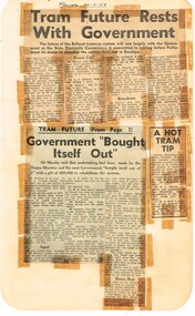
Newspaper, State Electricity Commission of Victoria (SEC) and The Courier Ballarat, Tram future rests with Government, Feb. 1962
Yields information about the views of various letter writers, views of the Courier, union views, rehabilitation costs Geelong, public meetings and meetings with SEC.Set of three Foolscap sheet of plain paper, with rounded corners, with newspaper cuttings, concerning the mooted closure of the Ballarat Tram system 20 Feb and 22 Feb 1962. All from The Courier, unless noted otherwise. 7940.1 1 - "Tram future rests with Government" - 22-2-62 - news report about the SEC being insistent on tabling the motion to close in Parliament, price of replacement trams. Attending Mr K L Murray, Mr Linaker, Mr A V Mawby of the SEC, Cr. A Pittard and Town Clerk Mr. H H Maddern. 2 - "Government "Bought itself out" - continuation from above, quoting Mr Mawby about the rehabilitation of the system in 1934 by the Government, discussions about fares, losses, time of travel from Sebastopol compared to buses. Also notes Cr Tuppen of Sebastopol. 3 - "A hot tram tip" - 22-2-62 - suggestion by Cr Cooper suggested the tram be retained around the lake for Historical reasons, Mr Murray of the SEC, sell/give to the Historical Society, Cr W E Roff replied about not wanting them and put them in a tip. 7940.2 1 - "SEC Not to sell this - 20-2-62 - photo of the power house in Ripon St, with the caption that the SEC did not propose to sell the property, but would be selling the tram depot site. 2 - "The talk was trams" - 22-2-62 - photo of Mr Mawby, Cr A D Mason, H Linaker and Mr K L Murray at the meeting with Council the previous day. 3 - "Save our Trams" - 21-2-62 - long letter - about the closing the trams and railway losses including building, new rail lines being built. 4 - "Tram fight" - letter by R Courtney Union Secretary, about the formation of a Committee to oppose closure. 7940.3 "Sound Shell Plan+ - 21-2-62 - Long editorial about the construction of a Sound Shell and council discussions and inability to make a decision.closure, letter to the editor, editorial, sec, rehabilitation, staff, buses, concession fares, museum, power station, ballarat a power station, botanical gardens -
Port Melbourne Historical & Preservation Society
Book, Kate Shaw et al, Ewan Ogilvy's Bayside Papers, Box Three - Bayside Views - A Collection of critical perspectives on the Bayside Development, 1988
Ewan OGILVY, former Melbourne Councillor and also of Community Services Victoria, Inner Urban Ministerial Advisory Committee and Uniting Church's Centre for Urban Research and Action (CURA), was instrumental in social justice approaches to town planning. He and CURA's Social Justice and the City Project funded Port Melbourne community groups protesting against the SCDC development in 1987. His files were presented to the Society in May 2001 on his preparation for leaving Victoria.From Ewan OGILVY'S chronologically organised 'Bayside Papers' relating to the proposed development of Port Melbourne industrial land in the late 1980s: Bayside Views - A Collection of critical perspectives on the Bayside Development, a book of essays on Bayside issues, 1988 - funded by the Justice in the City projectSigned 'Ewan Ogilvy'town planning, town planning - proposals shelved - bayside, public action campaigns, environmental issues, public housing, missions to seamen, centre for urban research and action (cura), uniting church, sandridge city development co pty ltd, scdc, linton r lethlean, barry pullen, ewan ogilvy -
 Eltham District Historical Society Inc
Document - Property Binder, 616 Main Road, Eltham; Plum Cottage
Plum Cottage is covered by Heritage Overelay HO256 in the Nillumbuk Planning Scheme This two-lot land holding was created as a subdivision and sold to Charles Stuart McNeil by May 1955. Sometime in the period 1955-1960, the builder-designer, John Harcourt had created a pise house on the site, straddling the two subdivision lots. The designer, John M. Harcourt was a pioneer builder in pise-de-terre and mudbrick in the Eltham Shire, Eltham being synonymous with alternative lifestyles and building practises until the onset of suburbia in the late 20th and early 21st centuries. This hipped-roof house is set high above Main Road on a V-shape plan characteristic of the Arts & Crafts style, with rammed earth or pise walls, timber joinery and a cement tiled roof. The V shape plan was used by important English and Eltham Arts & Crafts designers. The use of natural materials such as stone and timber construction is an essential part of the Arts & Crafts style and Harcourt’s work. So too is the application of the style on both the exterior and interior of the house as a holistic concept. The house adjoins the Lim Joon adobe house built and designed by Alistair Knox in the same era (HO119), thus forming a distinctive pair, both using an uncommon plan form. This house was identified in the Shire of Shire of Eltham Heritage 1992 as contributory to the Eltham Gateway Conservation Area, then proposed as an urban conservation area (now Heritage Overlay Area). Land Ownership Emily Jane Smith of 12 Woodside Street Fitzroy owned Crown Allotments 1 & 2 Sections 14, 27 by August 1918, selling to William Henry Smith of 12 Woodside Street, Nth Fitzroy May 1921. (John) James Isherwood of Main Road, Eltham owned the property by 1928 (the year of his death) with the beneficiary of his estate and next owner of this site being his widow, Minnie Maria Isherwood of Cemetery Road, Eltham. His holding in Main Road included parts of what was described in rate records as allotments1 & 2 Section E6. In the late 1930s, early 1940s her son Alfred John Isherwood was also rated for the land around this site, with the rated nett annual value varying between £2 and £5. Alfred Isherwood also lived at Main Road, Eltham with his wife Ellen: her early death at the age of 24 was reported in the Argus of 1923. Part of the Isherwood land was divided off and sold to Charles Stuart McNeil by May1955. Sometime in the period 1955-1960, the builder-designer, John Harcourt had created a pise house on the site, straddling the two subdivision lots. The house is visible on an aerial photograph from 1960s. Reputedly the house was called Plum Cottage and erected for Harcourt’s mother-in-law. A garage was added in 1959. Charles McNeil died in1971 aged 87: he was the son of Don McNeil and Margaret Arkell. Available rate records from the construction era start in the of the 1970s (1972-3) and list Mr H.C. & M/S A.V. Charity at 616 Main Road Eltham of this property with a nett annual value of $740. More recent valuer's data describes the property as lots 1 & 2 LP25668, located in the Central Riding of Eltham Shire, owned by Ann Valerie Charity and later, in 1990, by the Chincarini family. Building Description This hipped roof 11 .5 square house is set high above Main Road on a characteristic-shape plan and has rammed earth or pise walls, timber joinery and a cement tiled roof. The V-shape plan was used by Important designers such as C.F.A. Voysey (UK) who interpreted medieval domestic architecture as part of the Arts & Crafts style of the late 19th and early 20th centuries. The pise walls are covered with a textured render while the cement roofing tiles are also seen in the Harcourt Hill examples. Reputedly the ceiling joists are of a deep section and span long lengths with no need for hanging beams in the roof space. The ceilings are low and panelled in main rooms with apparently Caneite soft board infill panels between the exposed ceiling beams. These are painted white but may have been stained at one time. The focus of the house is the large living area with its vast random stone fireplace. Significance Plum Cottage is significant to the locality of Eltham because: Historically: • Plum Cottage is closely associated with the important historical theme of earth construction evident in Eltham and elsewhere in the Shire since theear1y Arts & Crafts inspired creations at Penleigh Boyd's The Robins (1912, HO101) and those at Montsalvat (1934-, HO82) but more prominent from the Second War period when earth building in Eltham was promoted in national periodicals as an alternative building method that avoided the building materials shortages of that era; • The choice of the earth building technique also expresses the theme of refuge or alternative living, synonymous with Eltham in the early to mid 20th century; • as a good example of domestic architecture from John Harcourt who was the first major post Second War figure in an important phase of Eltham’s earth building development, using his characteristic Old English or Arts& Crafts style that relies in this case on the pise wall construction, pitched roof forms, exposed ceiling joists, half timbering, random stonework, and panelled internal wall finishes. Architecturally: • Plum Cottage's pise wall construction is uncommon among the early earth-walled structures in the Shire, that are mainly of adobe or mud brick, and as a building material is uncommon among the Shire’s suburban dwellings generally which are clad typically with either fired clay bricks or timber boarding. Aesthetically: • Plum Cottage is a good and well preserved example of a modern Old English or Arts & Crafts style earth-walled building in the Shire • For the proximity of the significant Lim Joon adobe house designed by Alistair Knox adjoining to the north, providing a distinctive earth wall house pair, with uncommon plan forms. Reference Heritage Assessment of Plum Cottage, 616 Main Road, Eltham; Graeme Butler & Associates 2010main road, eltham, property, houses, (john) james isherwood, alfred john isherwood, ann valerie charity, arts and crafts style, charles stuart mcneil, chincarini family, eltham gateway zone, emily jane smith, h.c. charity, heritage assessment, john harcourt, john m. harcourt, lim joon house, main road eltham, minnie maria isherwood, pise construction, plum cottage -
University of Melbourne, Burnley Campus Archives
Plan - Photocopy, Proposed Reserve for Horticultural and Experimental Garden in the Survey Paddock Richmond, 1862-1948
Photocopy of Plan Gazetted 01.08.1863. From Central Plan Office Department of Natural Resources.Original signed by Clement Hodgkinson, Deputy Surveyor General. Stamped Department of Lands and Survey 7.12.48 Neg.18377. Handwritten notes on back "Melb Roll 23, R.19(A)"burnley, horticultural and experimental garden, survey paddock, richmond, clement hodgkinson -
 Narre Warren and District Family History Group
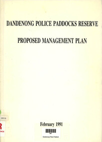
Book, Dandenong Police Paddocks Reserve proposed management plan, 1991
... The proposed management plan for Dandenong Police Paddocks Reserve ...The proposed management plan for Dandenong Police Paddocks Reserve published in February 1991non-fictionThe proposed management plan for Dandenong Police Paddocks Reserve published in February 1991dandenong (vic.), dandenong police paddocks reserve -
Whitehorse Historical Society Inc.
Map, Yarran Dheran Charts, 1974
Charts relating to the formation of Yarran DheranRolled charts of various dimensionsnon-fictionCharts relating to the formation of Yarran Dheranyarran dheran, yarran dheran advisory committee, thompson paul -
 Ringwood and District Historical Society
Map, Plan of Subdivision - State School Estate, Ringwood East, Victoria - (Undated, circa 1920s)
... Locality plan includes reference to proposed Ringwood East...Locality plan includes reference to proposed Ringwood East ...Map of land for sale attached to green cardboard backing with handwritten notations showing numbered allotments on Dublin Road, Holland Road, King Street, Charles Street and Purser Avenue, Ringwood East.Locality plan includes reference to proposed Ringwood East railway station which opened in 1925. -
Surrey Hills Historical Society Collection
Work on paper - Vertical file, Beckett Park and Maranoa Gardens
1. ‘Observation tower Beckett Park’, B.H. Reporter, 23.11.1934 (2 pages). 2. ‘Glory of a native garden’, F. Chapman, Literary Section unknown paper, 2.9.1939 (1 page, 2 copies original and copy). 3. Copy ‘Centenary tower’, The Herald, 21.5.1937 (1 page). 4. ‘Maranoa’, Camberwell City News, August, 1990 (1 page). 5. ‘Rotary Club’s gift to garden’, ? Age, 1990s ? (1 page) 6. ‘Maranoa Gardens & Beckett Park’ supplement, Boroondara Bulletin, 1997 (2 page spread). 7. ‘Beckett Park revisited’ by Annie Gillison, 8.7.1985, Melbourne Week ? (1 page). 8. Maranoa gardens Boroondara Council brochure (undated) (1 page). 9. Re Mr. Arthur J. Swaby, information from various sources, undated (1 page). 10. Beckett Park – ‘Glory of a Native Garden’, F. Chapman, unnamed newspaper, 2.9.1939, copy. (1 page). 11. Beckett Park: information re Robert Beckett from various sources (2 pages). 12. ‘Most will like gardens plan’, unnamed newspaper, letter from Dennis Whelan, undated (1 page). 13. Extracts from J.A. Allan’s unpublished history of Camberwell re Beckett Park & Maranoa Gardens, undated (1 page). 14. Maranoa Gardens Self-guided walk, undated (4 page brochure). 15. Notes on F. Chapman and interests, various sources, (2 pages). 16. Empire Day celebrations, extract from Argus, 24.5.1937 (1 page). 17. Extract from Camberwell Conservation Plan, 1989 by McConville (1 page). 18. ‘A lesson in serenity’, Maranoa Botanic Gardens, Balwyn, Domain Review, 7.7.2021 (2 pages). 19. Boroondara City Council Notice of proposed naming of reserve, Progress Leader, 5.12.2019 (1 page). 20. Maranoa Botanic Gardens, undated (double sided pamphlet). 21. 2 extracts from Box Hill Recorder, 23.10.1925 and 27.11.1925 (1 page). 22. Extract from BHR, 15.1.1926 ‘Visit of Field Naturalists Club of Victoria’ (1 page).