Showing 1497 items
matching yard
-
 Ballarat Clarendon College
Trophy, Junior Cup 1902
E Holgate went on to serve with distinction in World War 1 and awarded a Military Medal in Belgium in 1917. The College Cup (Junior and Senior) was awarded to the competitor who won all three 120, 250 and 440 yard races. For more information about the College Cup see Ring-A-Roo December 1993.Significant indication of the place of athletics within the school program in the late 1800's.Large, ornate, engraved silver cup with two handles on wooden standInscription on cup face: JUNIOR CUP / won by / E HOLGATE Inscription on cup verso: BALLARAT COLLEGE / Minervan / 1902 edward-spencer-holgate, trophy, silver-cup, junior-cup, w-w-1, ballarat-college, -
 Eltham District Historical Society Inc
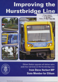
Folder, Hurstbridge Line Upgrade, 2010
Correspondence and information from the State Government about the Hurstbridge Line upgrade 2010. Also includes newspaper articles, Nillumbik Shire Council minutes report, map and contextual information regarding the Eltham Major Activity Centre structure Plan 2009. The main area of concern was the plan to reconfigue the Eltham stabling yard.23 documents, 62 pages of news clippings, photocopies and colour political fliersHG Folders 108 and 115harry gilham collection, railway line construction, hurstbridge line, hurstbridge railway line, eltham railway station, eltham station carpark, train stabling yard -
 Lara RSL Sub Branch
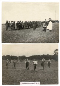
Sepia Photographs.( 2 of ), Gala Day 1919, 1919
The Returned Serviceman's Gala Day was held on the Lara main oval on Saturday 8th November 1919. Each returned serviceman was presented with a medallion with their name on it. Copies of the badge are held at the Lara RSL Sub Branch. Lt General Smith is presenting a badge to a serviceman in one photo. The other photo is the serviceman's race of 100 yardsRectangular shaped photographs ( 2 of )Returned service men WW1.ww1, returned service men, australian army, lara r.s.l.world war one. -
 Kew Historical Society Inc
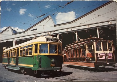
Postcard, Biscay Greetings Pty Ltd, Trams at Kew Depot, c.1991
The Kew tram depot is located on the corner of Barkers Road and High Street, Kew. It is one of eight tram depots on the Melbourne tram network. The depot opened on 8 May 1915. The main yard has 12 covered roads. There are two tracks for trams leaving or entering via Barkers Road, and a single track connecting to High Street.Postcard produced c.1991 to commemorate 75 Years of Service of The Kew Depot (1915/16-1991). The postcard shows two trams at the depot. The details are included in the information provided on the reverse.Kew Depot is ready for work W Class 892 waits for its next duty while visiting V Class 214 is ready for special work Photo by R. J. Marsh T101 Copyright Biscay Greetings Pty Ltd Telephone (03) 562 3599tramways - kew, kew tramways depot, -
 Orbost & District Historical Society
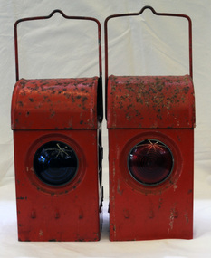
signal lamps
Possibly used in the Orbost district. Railway lamps of this kind were hand signalling lamps used by train guards, shunters and sometimes signalmen and station staff. They could signal the locomotive crew at night to let them know what to do (move forward/move backward/right-of-way) when leaving a station, goods yard or siding. Railway lamps of this kind were significant railway items in their period of use as essential tools to the safe-working operations of the railway. Two railway signal lamps. These are kerosene burning lamps made of metal and painted red. Both lamps have carrying handles at the top. .1 has a green glass lens and .2 has a red glass lens. signals lamps communication railway transport kerosene-burning -
Unions Ballarat
Photograph: Catherine King's campaign poster for November 2007 election, 20/9/07
Photograph: Catherine King's campaign poster for November 2007 election. The poster is erected in the front yard of a weatherboard home. A second identical poster is attached to the verandah area. Catherine King is the federal ALP member for Ballarat and has been office since 2001. She was a cabinet minister in the second Rudd ministry and is now part of the Shadow Cabinet. This poster comprises part of the campaign materials created to support the ALP's 2007 successful election campaign. Photographbtlc, ballarat trades hall, ballarat trades and labour council, king, catherine, kevin 07, alp, australian labor party, cabinet, politicians, elections, election campaigning -
 Wodonga & District Historical Society Inc
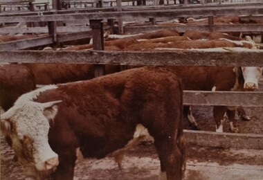
Album - Ringer's River by Des Martin - Plate 5 - Queensland cattle from the Gulf Country at auction
Baldies! Baldies! Baldies!. Thousands of Queensland cattle fill the yards at Camoola for the great store sale to which all the big Victorian buyers will come. Clients may purchase one pen with the option of the whole draft concerned, and the best of these cattle is the mob Danny Knowles has walked down from Boondangie Station in the Gulf Country.The album and images are significant because they document literature written by a prominent member of the Wodonga community. The presentation of this precis was supported by several significant district families and individuals.Ringer's River Album Coloured photo Plate 5des martin, many a mile, ringer's river, northeast victoria stories -
 Port Melbourne Historical & Preservation Society
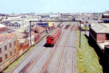
Photograph - Train, St Kilda to City at junction of St KIlda and Port Melbourne lines, 1950 - 1969
Suburban electric train of the swing door variety seen here inbound to the City from St Kilda having just joined the Port Melbourne lines at the former Port Melbourne & St Kilda Junction. The angle of the Port Melbourne lines over Clarendon St are the remains of the former Port Melbourne main line that went right through the middle of Montague Goods Yard seen in the background.transport - railways, red train -
 Phillip Island and District Historical Society Inc.
Photograph, Anderson Family & Homestead, 1888
Built in 1868 for Boarding House. Added to in 1887 - 88. Sold when Robert Anderson's second wife died. Several owners but came back into the family with Grandson Stan Anderson. Sold again when Stan died. Glen Isla now owned by Mr & Mrs Lunn who have restored it to its present condition. Now owned by Mr & Mrs Baker - 2018.House built in 1868, to become a Boarding House. A 2-story weatherboard building with brick chimney and filials at each point of gabled roof. Long windows. Attached at back and far side 2 single story joined gable roof buildings and adjoining wooden lattice building. Back yard white picket fence. 5 Figures out front. Built by Robert Andersonlocal history, photographs, buildings, historic., glen isla homestead, phillip island, black & white photograph, mrs emma anderson jacobs, robert coxon anderson -
 Surrey Hills Historical Society Collection
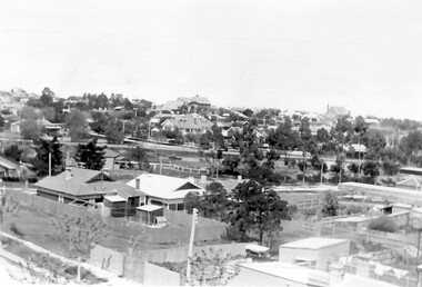
Photograph, Surrey Hills looking south-east from the steeple of Holy Trinity Church, 1921
The property in the foreground is 'Edgeware' at 171 Union Road, a house built by the Zeplin family. It became the home / residence of Dr Percy Liddle and later Dr James Landells Blakie. By the time this photo was taken Dr Blakie had moved across the road to 174 Union Road. In the background behind the 2 houses in the foreground is the Surrey Hills Stationmaster's house, sitting behind a picket fence. The Alan Holt register gives a build date of c1915 for this house, which fits stylistically. The first stationmaster was probably Michael Ginnane, who stayed in the area after he retired, moving to 1 Russell Street. This property was listed as 8 Bedford Avenue, the only house on the south side of the road. It was demolished in c1972 to make way for widening of the rail track with a third line. The photographer Norman Carter took many photos of Surrey Hills and Mont Albert from the 1920s, in particular of events and activities associated with the Church of England.Black and white photo taken from the steeple of Holy Trinity Church looking across housing towards the railway line and Albany / Windsor Crescents and on towards Canterbury Road. Surrey Hills Primary School and St Stephens Presbyterian Church feature prominently on the horizon. The stationmaster's cottage is centre left adjacent to a large conifer-like tree, with a white fence delineating the railway yards.On back of original: "6-11-21" and in a different hand in biro: "from tower of Holy Trinity Church"albany crescent, windsor crescent, st stephens presbyterian church, surrey hills primary school, railways, stationmasters' houses, bedford avenue, norman carter, edgeware, dr percy liddle, dr james blakie -
 Bendigo Historical Society Inc.
Photograph - BERT GRAHAM COLLECTION: GROUP PHOTO, May 1957
Black & white photograph, Bert Graham Collection, Alec Craig ( Mayor) at the opening of the , Mr. & Mrs. Tully gates at the Eastern Park in May 1957,on the gate pillar on the left is a plaque which reads ; Erected to Honour the Services rendered by Mr. & Mrs. J.P.Tully, May 1957. On the back. A.B.Martin 207 Williamson St. ( 100 yards above Roundabout) Bendigo Phone 150, 9.6.57 AHG..bendigo, clubs, eastern park -
 Bendigo Historical Society Inc.
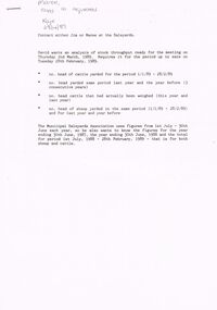
Document - BENDIGO SALEYARDS COLLECTION: LIVESTOCK TOTALS
Photocopy of six handwritten pages of totals of Cattle, Horse, B'by calves and pigs sold from July 87 to June 88. The front page has instructions for a typed copy for the number of cattle yarded from 1/1/89 to 28/2/89 and for the same period last year and the year before. Also the number of cattle that had been weighed. Also the same for the sheep.bendigo, council, cattle markets, bendigo saleyards collection - livestock totals, the municipal saleyards association -
 Bendigo Historical Society Inc.
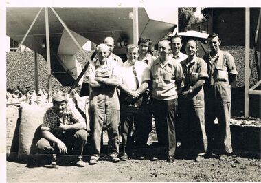
Photograph - CASTLEMAINE GAS COMPANY COLLECTION: PHOTO PEOPLE, 1974
From Left to Right: A. Varker (Yard Hand) - B.Hill (Distribution Foreman) - K. Jobe (Fitter) - T. Johnson (Distribution Manager) - L. Barrett (Fitter) - J. Botton (Leading Hand Stoker) - R. Macauley (Gas Fitter) - F. Bardell (Gas Fitter) - D. Dean (Gas Fitter). 1974 Location Unknown. Written on the front ''Our Intelligent staff await to serve you''photo, group, workers -
 Bendigo Historical Society Inc.
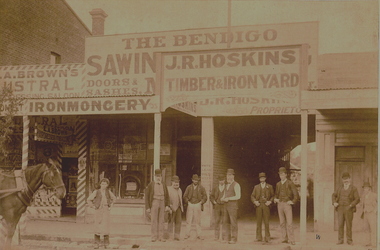
Photograph - J R HOSKINS TIMBER & IRON YARD, C1900
Sepia photograph. J R Hoskins Timber & Iron Yard. Timber premises, verandah. Horse on left hand side, 10 men posed in foreground. C A Brown's shop partly pictured on left side, hairdressing saloon. Physical description: faded. Inscriptions/Markings: Wall Bros. Photographers, 15 Chapel St., St. Kilda. Exactly Opposite All Saints' Church.Wall Brosorganization, business, bendigo timber & iron yards, wall bros photographers, 15 chapel st., st kilda, exactly opposite all saints' church. sent to bhs by jan goulding chs, reference in letter for further information contact mr larsen from the bright and district historical society -
 Whitehorse Historical Society Inc.
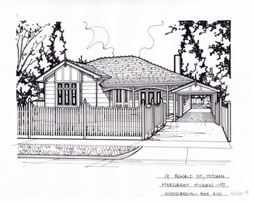
Artwork, other - Ink Line Drawing, Margaret Picken, 19 Ronald St., Mitcham, 1997
A property illustration by Margret Picken Commissioned by a real estate agency for the purpose of advertising 19 Ronald St., Mitcham. This property is listed as having sold for $230,000 in 1997 Made by using Rotring ‘Rapidigraph’ drafting pens with Rotring ink on Rapidigraph polyester drafting film, double matte. Trained as a cartographic draftsman within the mining industry, Margaret Picken is an artist who worked producing property illustrations for real estate agencies in eastern suburbs of Victoria from 1983-2005. Retiring from the industry as technological changes favored coloured photography over illustrations, and commissioning companies over sole contractors.This artwork is of Historical Significance as a record of local domestic architecture.A black ink line drawing on drafters film by Margaret Picken, of 19 Ronald St., Mitcham depicting a black and white line drawing of a single story weatherboard house with a bay window and porch with decorative facia. To the right is a driveway leading to a carport running alongside the house. In the foreground is a picket fence enclosing a front yard. There are two holepunch holes on just under the upper edge 19 Ronald St., Mitcham Margaret Picken - 97 Woodards - Boxhillwhitehorse historical society, schwerkolt cottage, housing, architecture, margaret picken, house, garden, real estate, mitcham -
 Whitehorse Historical Society Inc.
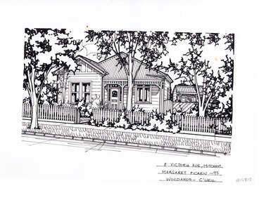
Artwork, other - Ink Line Drawing, Margaret Picken, 8 Victoria Ave., Mitcham, 1995
A property illustration by Margret Picken Commissioned by a real estate agency for the purpose of advertising 8 Victoria Ave., Mitcham Made by using Rotring ‘Rapidigraph’ drafting pens with Rotring ink on Rapidigraph polyester drafting film, double matte. Trained as a cartographic draftsman within the mining industry, Margaret Picken is an artist who worked producing property illustrations for real estate agencies in eastern suburbs of Victoria from 1983-2005. Retiring from the industry as technological changes favored coloured photography over illustrations, and commissioning companies over sole contractors.This artwork is of Historical Significance as a record of local domestic architecture.A black ink line drawing on drafters film by Margaret Picken, of 8 Victoria Ave., Mitcham depicting a black and white line drawing of a single story weatherboard cottage, with corrugated roof. In the foreground is a picket fence enclosing a heavily planted front yard. On the right a weatherboard 'cubby' can be seen over the garden fence. There are two holepunch holes on just under the upper edge 8 Victoria Ave., Mitcham Margaret Picken - 95 Woodards - C'wellwhitehorse historical society, schwerkolt cottage, housing, architecture, margaret picken, house, garden, real estate, mitcham -
 Whitehorse Historical Society Inc.
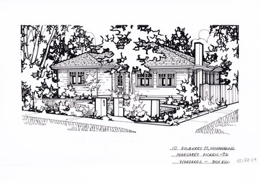
Artwork, other - Ink Line Drawing, Margaret Picken, 10 Holberry St., Nunawading, 1992
A property illustration by Margret Picken Commissioned by a real estate agency for the purpose of advertising 10 Holberry St., Nunawading. This property is listed as having sold for $139,000 in 1992 Made by using Rotring ‘Rapidigraph’ drafting pens with Rotring ink on Rapidigraph polyester drafting film, double matte. Trained as a cartographic draftsman within the mining industry, Margaret Picken is an artist who worked producing property illustrations for real estate agencies in eastern suburbs of Victoria from 1983-2005. Retiring from the industry as technological changes favored coloured photography over illustrations, and commissioning companies over sole contractors.This artwork is of Historical Significance as a record of local domestic architecture.A black ink line drawing on drafters film by Margaret Picken, of a black and white line drawing of a right hand side corner block single story weatherboard house with a footpath from the corner leading to the front door. At the start of the path are two pillars, one serving as a letterbox. The front yard is edged with garden beds. There are two hole punch holes on just under the upper edge.10 Holberry St., Nunawading Margaret Picken - 92 Woodards - Boxhillwhitehorse historical society, schwerkolt cottage, housing, architecture, margaret picken, house, garden, real estate, nunawading -
 Sunshine and District Historical Society Incorporated
Photographs (1928), 'QUARTER MILE' BRIDGE Construction, 1928
One man lost his life during the building of this bridge. The bridge was constructed by the Victorian Railways between 1927 to 1929 to carry a new double track goods line. This enabled trains from all parts of the state except Gippsland to have direct access to the Tottenham marshalling and sorting yards. These yards were constructed in the 1920's to relieve congestion in the Melbourne Yard near Spencer Street station. The congestion was being caused by the construction of suburban passenger platforms associated with the electrification of the suburban railway network. Initially the bridge was for goods trains but during the Second World War it was also used by troop trains. When the standard gauge line was built in 1962 all trains to Albury and Sydney have used this route, thus avoiding travelling through Essendon and Pascoe Vale on the suburban tracks. The standard gauge track across the bridge took the place of one of the broad gauge tracks so broad gauge trains crossing the bridge in either direction have to now use the same track. The bridge is 1,257 feet (383.13 metres) long and 180 feet (54.86 metres) above the water level. It is just 63 feet (19.2 metres) short of a quarter mile in length between abutments. There is a similar bridge on the same railway line crossing the Moonee Ponds Creek between Gowenbrae and Glenroy, however it is smaller at 1060 feet (323.08 metres) length and 115 feet (35.05) height.The bridge is now Victorian Heritage Registered under Number: H1197, and Heritage Overlay Numbers HO5, and HO107. On the Heritage Register it is named RAIL BRIDGE (ALBION VIADUCT). According to the Heritage Report the bridge is scientifically and architecturally important because of its large size, and because of the cost effective design features such as two girders per span (one for each track), the K bracing in the towers, and the broad flange beams as columns. When it was being built it was the largest trestle bridge in Australia, and until the Sydney Harbour bridge was constructed it was the highest railway bridge.Five B&W yellowing photos showing stages of construction of the Maribyrnong River Viaduct known as the Trestle Bridge but mainly known locally as the QUARTER MILE BRIDGE. It is a railway only bridge which runs over the Maribyrnong River between Sunshine North and Keilor East. A sixth image, which is not part of this set of photos, is included to show what the completed bridge looks like. -
 Waverley RSL Sub Branch
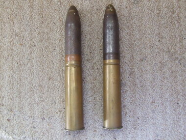
Shell 40 Cal
The Bofors 40 mm gun, often referred to simply as the Bofors gun, is an anti-aircraft/multi-purpose autocannon designed in the 1930s by the Swedish arms manufacturer AB Bofors. It was one of the most popular medium-weight anti-aircraft systems during World War II, used by most of the western Allies as well as by the Axis powers. The shells were manufactured according to a British design after it was discovered that the Swedish shells had much too sensitive a contact fuse, "which functioned on impact with rain drops". Although the shells could nominally reach out to 11,000 yards (10,000 meters), almost all the shells manufactured had self-destroying tracers that detonated the rounds at a range of 4000-5000 yards (3700-4600 meters.) This helped prevent friendly fire incidents or other collateral damage. In addition to the TNT bursting charge, the shell contained a pellet of powdered magnesium and aluminum as an incendiary. Production of ammunition peaked at 12 million rounds per month in the winter of 1944. Ammunition type Contact fused HE/incendiary fixed shell. AP shells were also available. Projectile weight 1.985 lb 0.80 kg Velocity 2890 feet/s 881 m/s Maximum elevation 90 degrees Range 11,000 yards 10,000 meters Altitude 22,800 feet 6950 meters Rate of fire 120 rounds per minuteCollected by Norman Hall D.J Hall 17455 RAN2 shells (complete) for a Bofors 40mm Anti Aircraft Gun used by the R.A.N.See Imagesbofors 40 mm, anti aircraft gun, shell, r.a.n. bofors gun, world war ii, wwii, norman hall -
 Ringwood and District Historical Society
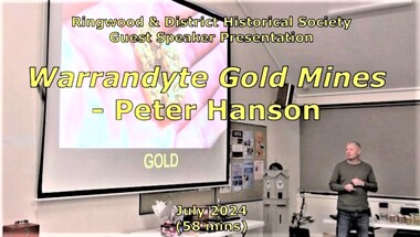
Mixed media - Video, RDHS Guest Speaker Presentation - "Warrandyte Gold Mines" - Peter Hanson
Digitised video (2.73GB). Duration: 58 minutes. Recorded July, 2024. (Video is available for viewing at Ringwood & District Historical Society Archives by appointment)Guest Speaker, Peter Hanson grew up in Warrandyte surrounded by signs of gold mining activities including in his own back yard. In this presentation, Peter talks about the numerous diggings in the area, with images, maps and drawings of the mines, tunnels and shafts above and below ground. -
 Queenscliffe Maritime Museum
Functional object - Bathing Box No. 24, unknown - possibly 1935
Borough of Queenscliffe Bathing Boxes had to be registered to a particular rateable property. Bathing Box No. 24 belonged to a property in Simpson Street, Point Lonsdale The Bathing Boxes at Point Lonsdale were loaded onto trolleys and taken back to the property during winter so they were not destroyed by the wild weather. Eventually they became garden sheds in the back yards of residencies.Bathing Box No. 24 is one of a very few still remaining due to recent home extensions.Weatherboard with Galvanised Iron Roof with Wooden Slatted Air Vent. -
 Eltham District Historical Society Inc
Photograph, Eltham Feed Store, cnr Main Road and York Street, c.1985, 1985
Originally a grocery store when the Moar brothers lived at number 11 in the 1950s, run by Cockcrofts. After Cockcrofts it was Davis and they turned it into a hardware store and timber yard at the side. [Note: dated based on negatives 01791 (20 Jan 1986) as service station (in other frames on roll of film) and pricing for fuel very similar period; possibly late 1985]Reflects on the changing nature of the local street-scape and housesRoll of 35mm colour negative film, 7 stripsKodak CL 200 5093eltham, york street, main road, eltham feed store, shops -
 Kiewa Valley Historical Society
Map - Topographical, Ski Club of Victoria Bogong High Plains and Adjacent Peaks, Early 1930's
This map has been in the Ryder family for approx. 70 years. Probably used when bush walking and skiing in the early days on the Bogong High Plains. The Ryder family are farmers in the Kiewa Valley and were involved in taking their cattle up to the Bogong High Plains where they had a lease. The State Electricity Commission of Victoria constructed the Kiewa Hydro Electric Scheme opening up the area during the 1940's and 1950's. This type of map is an early one, used by people in the Kiewa Valley and possibly by surveyors prior to construction.The map is an early topographic map used by farmers living in the Kiewa Valley. It is historically significant as these people were involved in taking cattle up to the High Plains during summer and may have been used for bush walking and skiing.This is a sepia coloured paper map which was originally printed copyright registered. It was revised in 20/6.33/4.4.37/8.4.40/24.8.43/19/6/54. It shows roads / tracks / snow poles / snow pole numbers (27) / Snow pole spacing (3 chains. 66 yards) approximately 27 poles to the mile / height above sea level in feet - 5280. Water courses not definitely located etc.Rocky Valley Dam (Kiewa Hydro Electric Scheme) has been drawn on the map by hand with a biro. There is a wooden rod at the top of the map.topographic map; kiewa valley; ryder family; high plains of victoria -
Tatura Irrigation & Wartime Camps Museum
Document, Certificate of Right of Burial in the Tatura Public Cemetery, Lease,Account from West End Timber Yards for Coffin
Photocopies of original documentsPhotocopies of Certificate of Right of Burial in the Tatura Public Cemetery dated 15/01/1906 and 2 receipts for same plots labelled Toolamba West Public Cemetery dated 6/12/1905, Lease between John Herbert Davies & Catherine Heaphy for the Criterion Hotel Tatura, Account from West End Timber Yards (A. Miles) for Coffin and Hearse & Conducting Funeral. All are photocopies on A4 paper.tatura, heaphy, cemetery, criterion hotel, west end timber yards, davies, cussen, documents, certificates -
 Whitehorse Historical Society Inc.
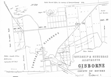
document - Map, Melbourne Metro, 1978
Collection of reproductions issued by the Public Record Office in 1978. Comprises: Allotments in the Black Forest, 1857; Township of Dandenong, 1856; Township and suburban allotments, Gisborne, 1857; Storing Yard allotments near the Melbourne Wharf, 1854; Town lots near the Railway Terminus, Melbourne, 1863; Parish of Prahran, 1853; Township of Sandridge, 1855; Township of Sunbury, 1857; River Yarra Yarra at the Queens Wharf, 1860.victoria. public record office, black forest, victoria, dandenong, gisborne, melbourne wharf, railway terminus, spencer street, melbourne, prahran, sandridge, sunbury, queens wharf -
 Ballarat Tramway Museum
Photograph - Digital image, W. J. Llewelyn, c1955
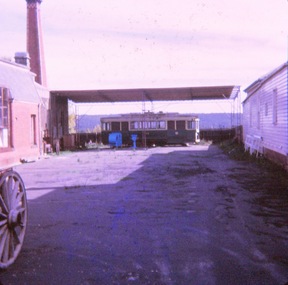
Set of two colour digital images taken by W. J. Llewelyn. .1 - Armstrong Street from the Town Hall tower - shows the street view, car parking arrangements prior to the construction of the Ballarat City Hall, c1955. The new Civic Hall was opened in 1956. Shows the railway timber yard. .2 - Sturt St showing Town Hall and the Myers building late 1950's? trams, tramways, armstrong st, railway, town hall, myers -
 Ballarat Tramway Museum
Slide - 35mm slide/s - set of 6, John Theodore, 1972 - 1973
Yields information about tram 11 following its disposal and how it was placed at the Daylesford Museum.Set of 1 Kodachrome cardboard slides and 5 AGFA blue and white plastic mount 27mm sq slides of former Ballarat tram 11 at the Daylesford Historical Society yard. .1 - view from the roadway .2 - late view with other farm machinery placed around it. .3 - interior view .4 - interior view .5 - view showing how the tram was placed. .6 - interior viewed.Various notations by John as to the slide number and the trams in pencil and ink.tramways, trams, closure, tramcars, disposal, daylesford, tram 11 -
 Melbourne Tram Museum
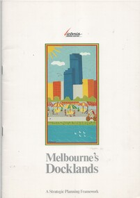
Document - Report, Ministry for Planning and Environment, "Melbourne's Docklands - A Strategic Planning Framework", 1989
Report - 32 A4 pages centre stapled colour printed on gloss paper, titled "Melbourne's Docklands - A Strategic Planning Framework", dated August 1989. Has a foreword by Tom Roper Minster for Planning and Environment. The report with a table of contents looks at the development of the Victoria Docklands area to the west of the railway yards. Has a good colour photograph of the area. Includes public transportation links using trams.trams, tramways, docklands, planning, melbourne, new track, public transport -
 Lakes Entrance Regional Historical Society (operating as Lakes Entrance History Centre & Museum)
Postcard, 1920c
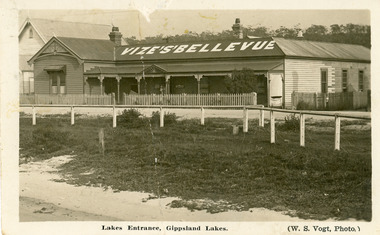
Also photographic enlargement 20 x 25, also enlargement copy 28 x 35 in frameless frame. Also re Donor, Mrs Lucy King, previously Sanberg, nee Olsen, was the proprietor of Bellevue Guesthouse 1946 to 1988Black and white postcard of Vizes Bellevue Guesthouse, showing a large weatherboard building, corrugated iron hipped roof, gable at left front. Veranda across the front, picket fence enclosing front yard. Wire strung wooden fence between roadway and grassy area bordering sandy beach at lake edge. Kerosine tin on grass, church visible beside guest house. Lakes Entrance Victoriaguesthouses, waterfront, architecture -
 Bendigo Historical Society Inc.
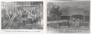
Photograph - HARRY BIGGS COLLECTION: J R HOSKINS BENDIGO TIMBER & IRON YARDS
Photograph. Harry Biggs Collection. 2 small black & white photos of J R Hoskins Timber & Iron Yards. Photo 1 - A corner of the moulding mill at J R Hoskins - it shows men working at the mill - inside in a large shed. Photo 2 - The front of the business in Hargreaves & Queen Streets, Bendigo. 2 horses & carts with a load of timber on them. There are also 9 men standing at the front.organization, business, commercial, harry biggs collection, j r hoskins timber & iron yards