Showing 1942 items matching " flooding"
-
 Kew Historical Society Inc
Photograph - Flooding of the Yarra River in North Kew, 1934
North Kew, now divided between Kew and Kew East, bordered the Yarra River. As such, it was a region subject to flooding in the Yarra Valley. Development beyond this point (ie Kellett Grove) was limited by the City of Kew's planning regulations. Prior to urban development, the area since European settlement and the first land sales in the district in the 1840s, had been used for dairy farming. Small sepia snapshot of floodwaters taken from near Kellett Grove, in what was then known as North Kew. The point of view is from a backyard looking towards Fairfield. In the foreground ar two men in a rowboat.Verso: OUR BACKYARD / Stamped 3 163yarra river -- north kew, floods -- yarra valley, floods -- north kew, floods -- 1934, natural disasters -- kew -
 Kew Historical Society Inc
Photograph - Flooding of the Yarra River in North Kew, 1934
North Kew, now divided between Kew and Kew East, bordered the Yarra River. As such, it was a region subject to flooding in the Yarra Valley. Development beyond this point (ie Kellett Grove) was limited by the City of Kew's planning regulations. Prior to urban development, the area since European settlement and the first land sales in the district in the 1840s, had been used for dairy farming. Small sepia snapshot of floodwaters in North Kew. The point of view is of two houses belonging to local families that were surrounded by floodwater. Verso: HYATTS HOUSE / WILLSMERE ROAD / Stamped 3 163yarra river -- north kew, floods -- yarra valley, floods -- north kew, floods -- 1934, natural disasters -- kew, willsmere road -
 Kew Historical Society Inc
Photograph - Flooding of the Yarra River in North Kew, 1934
North Kew, now divided between Kew and Kew East, bordered the Yarra River. As such, it was a region subject to flooding in the Yarra Valley. Development beyond this point (ie Kellett Grove) was limited by the City of Kew's planning regulations. Prior to urban development, the area since European settlement and the first land sales in the district in the 1840s, had been used for dairy farming. Small sepia snapshot of floodwaters in North Kew, from the rear of 8 Kellett Grove. Verso: OUR BACKYARD / Stamped 52yarra river -- north kew, floods -- yarra valley, floods -- north kew, floods -- 1934, natural disasters -- kew, willsmere road -
 Kew Historical Society Inc
Photograph - Grandfather and granddaughter in the yard of 8 Kellett Grove, Kew, 1934
North Kew, now divided between Kew and Kew East, bordered the Yarra River. As such, it was a region subject to flooding in the Yarra Valley. Development beyond this point (ie Kellett Grove) was limited by the City of Kew's planning regulations. Prior to urban development, the area since European settlement and the first land sales in the district in the 1840s, had been used for dairy farming. Vivid photograph contrasting domestic life and relationships with natural disasters such as the flood of 1934.Small sepia snapshot of a grandfather and granddaughter sitting in the backyard of 8 Kellett Grove, North Kew, with the floodwaters stretching behind them.Verso: GRANDDAD AND I IN BACKYARDyarra river -- north kew, floods -- yarra valley, floods -- north kew, floods -- 1934, natural disasters -- kew, willsmere road -
 Kew Historical Society Inc
Photograph - Flooding of the Yarra River in North Kew, 1934
North Kew, now divided between Kew and Kew East, bordered the Yarra River. As such, it was a region subject to flooding in the Yarra Valley. Development beyond this point (ie Kellett Grove) was limited by the City of Kew's planning regulations. Prior to urban development, the area since European settlement and the first land sales in the district in the 1840s, had been used for dairy farming. Vivid photograph contrasting domestic life and relationships with natural disasters such as the flood of 1934.Small sepia snapshot of the donors grandfather rescuing the family dog's kennel from rising floodwaters at the rear of 8 Kellett Grove, North Kew, .Verso: DAD SECURING NIPPY'S DOG KENNEL / Stamped 6414yarra river -- north kew, floods -- yarra valley, floods -- north kew, floods -- 1934, natural disasters -- kew -
 Kew Historical Society Inc
Photograph - Flooding of the Yarra River in North Kew, 1934
North Kew, now divided between Kew and Kew East, bordered the Yarra River. As such, it was a region subject to flooding in the Yarra Valley. Development beyond this point (ie Kellett Grove) was limited by the City of Kew's planning regulations. Prior to urban development, the area since European settlement and the first land sales in the district in the 1840s, had been used for dairy farming. .Small sepia snapshot of a local family's house in what was then River Avenue, North Kew being surrounded by floodwaters.Verso: THE SIDE OF RYANSyarra river -- north kew, floods -- yarra valley, floods -- north kew, floods -- 1934, natural disasters -- kew -
 Kew Historical Society Inc
Photograph - Flooding of the Yarra River in North Kew, 1934
North Kew, now divided between Kew and Kew East, bordered the Yarra River. As such, it was a region subject to flooding in the Yarra Valley. Development beyond this point (ie Kellett Grove) was limited by the City of Kew's planning regulations. Prior to urban development, the area since European settlement and the first land sales in the district in the 1840s, had been used for dairy farming. .Small sepia snapshot of what was then River Avenue, North Kew submerged by floodwaters.The photo was taken in the vicinity of 8 Kellett Grove, North Kew. Verso: TAKEN FROM OUR STREET JUST SEE A BIT OF RYAN'S FENCE / 1934yarra river -- north kew, floods -- yarra valley, floods -- north kew, floods -- 1934, natural disasters -- kew -
 Kew Historical Society Inc
Photograph - Flooding of the Yarra River in North Kew, 1934
North Kew, now divided between Kew and Kew East, bordered the Yarra River. As such, it was a region subject to flooding in the Yarra Valley. Development beyond this point (ie Kellett Grove) was limited by the City of Kew's planning regulations. Prior to urban development, the area since European settlement and the first land sales in the district in the 1840s, had been used for dairy farming. .Small sepia snapshot of the devastation caused by the 1934 flood.The photo was taken in the vicinity of Kellett Grove, North Kew and includes the roof of Chipperfield's Boathouse as well as other local houses.Verso: THIS IS CHIPPERFIELD'S BOAT SHEDS & COES & WILLIAMS TAKEN FROM OUR STREET / 1934yarra river -- north kew, floods -- yarra valley, floods -- north kew, floods -- 1934, natural disasters -- kew, chipperfields boathouse -
 Kew Historical Society Inc
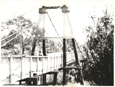
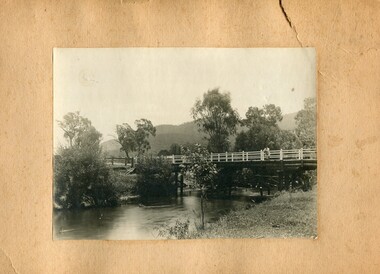
Photograph - Photograph (copy), Kanes Bridge, Studley Park, 195-1955
In 1928 a footbridge was erected to link Kew with the public golf course across the Yarra. The total cost of construction came to 250 pounds and the bridge became known as Kane's Bridge. During the 1934 floods the bridge was washed downstream, and was subsequently rebuilt. The present form of the bridge resembles the earlier bridge which crossed from the Yarra Bend Asylum to Kew, further upstream. (VHD)This work forms part of the collection assembled by the historian Dorothy Rogers, that was donated to the Kew Historical Society by her son John Rogers in 2015. The manuscripts, photographs, maps, and documents were sourced by her from both family and local collections or produced as references for her print publications. Many were directly used by Rogers in writing ‘Lovely Old Homes of Kew’ (1961) and 'A History of Kew' (1973), or the numerous articles on local history that she produced for suburban newspapers. Most of the photographs in the collection include detailed annotations in her hand. The Rogers Collection provides a comprehensive insight into the working habits of a historian in the 1960s and 1970s. Together it forms the largest privately-donated collection within the archives of the Kew Historical Society.A photographic copy of an older photograph of Kanes Bridge."Kanes Bridge"kanes bridge, yarra river, bridges - kew (vic.) -
 Kew Historical Society Inc
Archive (series) - Subject File, Baby Health Centres, 1958
Various PartiesReference, Research, InformationKHS OrderSubject file containing photocopies and a journal published by the RHSV (69:1, June 1998). The article, ‘Baby Boon: The Infant Welfare Movement in Victoria’, was written by Margaret Flood. While the article only makes one reference to milk supplied by Kew dairies, it contains useful descriptions of the role of Baby Health Centres and their staff. A newspaper article/clipping (1991) refers to the establishment of the Baby Changing Room in Walpole Street. There is also a photocopy of W D Vaughan’s text on Baby Health Centres in Kew (1960).infant welfare centres - kew (vic.)infant welfare centres - kew (vic.) -
 Kew Historical Society Inc
Map, MMBW, MMBW Plan No.68 Kew, 1900-1910
The Melbourne and Metropolitan Board of Works (MMBW) was established by an act of the Victorian Parliament in 1890 to prepare for and to implement a sewerage and water reticulation system across what was then inner Melbourne, its surrounding and middle distance suburbs, including Kew. The MMBW was disbanded in 1991.The map collection of the Kew Historical Society has at its core the historic maps assembled and originally stored in the City Engineer's Department of the City of Kew. These include maps in a number of scales. The vast majority of maps were produced by the MMBW in the first two decades of the twentieth century, and are solid working maps, backed by linen for durability. These maps are historically significant to Kew, the City of Boroondara and to the history of the development of state utilities in Victoria. A number of the Kew maps have additional details added by former municipal officers, including the levels reached by various floods. As these were working documents, information was added to them long after the period of their initial production and distribution.Early map of part of the Borough of Kew, created in the first decade of the twentieth century, at a scale 160 ft to 1 inch. The map covers what was then the north central part of Kew, bordered in the north by Oak Avenue, in the west by the Yarra River and Connor's Creek, in the south by Beresford and Carnegie Avenues, and in the east by Glass's Creek and Burke Road. The map shows the extent of urban development by that time, prominent institutions and the outlines of built structures in the municipality. Contour lines and the levels of historic floods were added in ink to the map at a later stage.MELBOURNE AND METROPOLITAN BOARD OF WORKS / PLAN NO. 68 / KEW melbourne & metropolitan board of works, mmbw maps, mmbw plans, borough of kew, cartography -
University of Melbourne, Burnley Campus Archives
Plan, School of Primary Agriculture & Horticulture - Burnley, c. 1925-1926
Copy of plan photographed at the Public Records Office Victoria. Central Administration Correspondence Files 1912-1939 ITEM. VPRS 10163/P0003/2. Accomodation Burnley School Part 1. Traced from M.M.B.W. Plan No. 42. Scale 160 ft=1 in. Level Datum L.M.N. Hobson's Bay. Traced by C.E.B.W. 16.02.1926. Additional matter in red and green inserted by F.E.T.C. 09.02.1926. Note by J.J. Rae (Principal). Lists W.C.s (toilets). Shows 1891 Flood Line. Possibly dates from 1925.prov, school of primary agriculture and horticulture, burnely, j.j. rae -
 Bendigo Historical Society Inc.
Document - DRAINAGE PROBLEMS - NEW CHUM LINE DRAINAGE PROBLEMS 1910
Handwritten extract from the Bendigo Advertiser 27/12/1910 Page 2. ''The Victoria Quartz, having deepened its shaft to 4,614 feet, had to abandon sinking on account of an inrush of water from the flooded mines to the south on the line. The influx occurred on the 15th of June, and notwithstanding that baling has been carried on almost constantly the company has failed to get the water out. It appears that the deep ground will have to be abandoned, owing to the absence of some proper scheme to cope with the water.'' Albert Richardson Mining History Collection.document, gold, drainage problems, drainage problems, new chum line drainage problems 1910, bendigo advertiser 27/12/1910 page 2, victoria quartz, albert richardson -
 Orbost & District Historical Society
book, Greenland, Kate, David Paten Memoirs, 2005
David Gordon Paten was born in 1917 in Orbost, Australia. He was the son of Evelyn Paten ( nee Roberston) and Thomas Paten who came to Orbost in 1893 and in 1907 began growing fancy bean seeds for H. James. He built the first private flood levee bank in the district. (ref Mary Gilbert) The book was edited by Kate Greenland on behalf of her grand-father, David Paten.This book of memoirs is a valuable reference for research into the early 20th century social history of Orbost.A 56 pp book with a plastic sheet cove. It is spiral bound in black plastic and is titled David Paten Memoirs. It was edited by Kate Greenland on behalf of her grand-father, David Paten.orbost-history paten-david -
 Eltham District Historical Society Inc
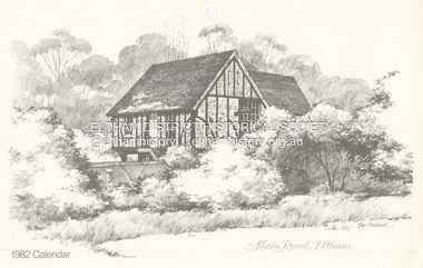
Calendar, Bill Caldwell, Sketch (reprint): Main Road, Eltham, Bill Caldwell n.d, c.1981
One of a series of sketches commissioned by Neville Emerson of Neville Emerson Real Estate, originally for use as christmas cards. EDHS does not hold a Christmas card of this image which was also used on the Wiregrass Gallery calendar for 1982. Whilst titled Main Road, Eltham, the house featured is that of Matcham Skipper which is raised on stilits due to the propensity of the Diamond Creek to flood. The actual address for the house is Dalton Street.Illustration from 1982 calendarart, artist, bill caldwell, fay bridge collection, neville emerson real estate, sketches, wiregrass gallery calendar, matcham skipper, dalton street -
 Eltham District Historical Society Inc
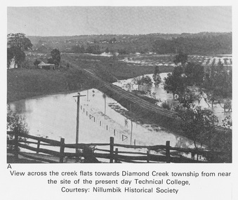
Work on paper (Sub-Item) - Photograph, View across the creek flats towards Diamond Creek township
Undated black and white photograph of view across the creek flats towards Diamond Creek township showing the railway line, with the Diamond Creek under flood. Situated behind the vicinity of Diamond Valley College, Main Hurstbridge Road, Diamond Creek. Diamond Valley College was formed in 1989 from the almagamation of Diamond Creek Technical School and Hurstbridge High School. Nillumbik Historical Society collectionflood, diamond creek, nillumbik historical society -
 Lake Bolac & District Historical Society
Black and white photograph, Lake Bolac Overflow, 1956
The outlet for the overflow was originally cut in 1926 and concreted over in 1928. This photo shows flooding into Salt Creek in 1956 and looks towards the west and Rockbank. Boards were added to raise the water level of the lake. These were put in annually, below the walkway depicted, until in 1966 the level of the concrete weir was raised. Consequently the lake did not flush through as readily and it gradually silted up and the lake became shallower.lake bolac, overflow, 1926, 1928, flood, 1966, salt creek, rockbank -
 Robin Boyd Foundation
Document - Script, Robin Boyd, The Flying Dogtor. Episode 10 Ghost Town, 1963
After the fire was distinguished and the flood subsided, on his way flying home, the Dogtor heard voices repeatedly on his radio "Calling Flying Dogtor". A sick voice asked for the Dogtor's help in the main street of Ghostville, the old mining town across Dry Gulch Gully, now a ghost town. He got to the abandoned address, 13 ("unlucky number") Spook Street. The Dogtor is about to open the door...The Flying Dogtor" series was broadcast on Australian Television Network (later becoming the Seven Network) between February and April 1964 (see item D254 for schedule).Typewritten, carbon copy, foolscap, 2 pagesPage 1: Left hand side has been amended and is attached with tape. Written corrections on right hand side.the flying dogtor, robin boyd, crawford productions, manuscript -
 Stawell Historical Society Inc
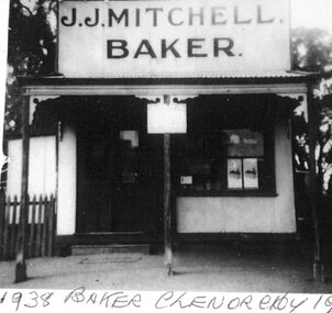
Photograph, Five photos of Glenorchy 1938
All photos taken around same time 1938 -1 1938 Baker Glenorchy J.J. Mitchell Baker -2 Bakers Chevrolet 1938 J.J. Mitchell Baker -3 Glenorchy Store 1938 J.H. Seeary General Store -4 Glenorchy Floods 1938 Old Post Office. Horses standing in Floodwater Outside Post Office with men on them -5 Glenorchy School 1938/1940 Five Black and White prints of Glenorchy with brownish Hue -
 Bendigo Historical Society Inc.
Newspaper - R.S.L. BENDIGO COLLECTION: NEWSPAPER CUTTINGS
Fourteen newspaper cuttings from the Bendigo Advertiser dated 18/8/1948, 31/3/1952, 3/6/1957, 11/2/1958 and 12/9/1958. Some cuttings have no dates. Most of the cuttings refer to the R.S.L. Some topics are: 15th Battalion V.D.C. Winds Up, Sir George Lansell Steps Down as President of the Bendigo R.S.L., R.S.L. Balls and the Unveiling of the Cenotaph. Other articles are the opening of the new Creche (1/6/1957) and the flooding of Charing Cross and Pall Mall by the Bendigo Creek.r.s.l. bendigo collection - newspaper cuttings, bendigo advertiser 3/6/1957 - 18/8/1948 - 31/3/1952 - 11/2/1958 - 12/9/1958, reg v brock -
 Kew Historical Society Inc
Photograph - Zig-Zag Bridge on the Yarra River at Kew, 1924
Henry Beater Christian (1886-1962) , was a descendant of one of the earliest settler families in Kew. Employed at the Kew Asylum as a 'public servant', he was a skilled amateur photographer, photographing numerous scenes in Kew and on his travels around Victoria. The majority of his photographs date from 1916 to 1929. His finest photographs are housed in two photograph albums. Digital copy of a photograph from page 8 of the 47-page photograph album containing 261 gelatinous silver images, loaned by Diane Washfold with permission given to digitise and hold a copy in our collection. The Zig-Zag Bridge linked the grounds of the Yarra Bend and Kew Asylums. The wooden bridge was constructed in the 1870s and lasted through numerous floods until its destruction in 1929. A horizontal structure, the walkway was reached via a wooden staircase on the Kew side. The steps were required due to the different levels of the banks on this stretch of the river. "Zig-Zag Bridge"henry beater christian (1886-1962), landscape photography, kew (vic.) — yarra river, christian-washfold collection, photograph albums, zig-zag bridge -
 Kew Historical Society Inc
Map, MMBW, MMBW Plan No.40 Collingwood & Kew, 1900-1910
The Melbourne and Metropolitan Board of Works (MMBW) was established by an act of the Victorian Parliament in 1890 to prepare for and to implement a sewerage and water reticulation system across what was then inner Melbourne, its surrounding and middle distance suburbs, including Kew. The MMBW was disbanded in 1991.The map collection of the Kew Historical Society has at its core the historic maps assembled and originally stored in the City Engineer's Department of the City of Kew. These include maps in a number of scales. The vast majority of maps were produced by the MMBW in the first two decades of the twentieth century, and are solid working maps, backed by linen for durability. These maps are historically significant to Kew, the City of Boroondara and to the history of the development of state utilities in Victoria. A number of the Kew maps have additional details added by former municipal officers, including the levels reached by various floods. As these were working documents, information was added to them long after the period of their initial production and distribution.Early map of part of the Borough of Kew, created in the first decade of the twentieth century, at a scale 160 ft to 1 inch. The map covers what was then the south western section of Kew, bordered on its north by Studley Park Road, in the west by Walmer Street and the River Yarra, by High Street South and Princess Street in the East and Barkers Road in the south. The map shows the extent of urban development by that time, prominent institutions and the outlines of built structures in the municipality. Contour lines and historic flood levels were added in ink to the map at a later stage.MELBOURNE AND METROPOLITAN BOARD OF WORKS / PLAN NO. 40 / COLLINGWOOD & KEWmelbourne & metropolitan board of works, mmbw maps, mmbw plans, borough of kew, cartography -
 Eltham District Historical Society Inc
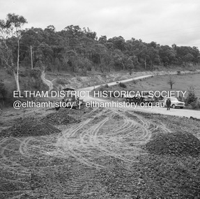
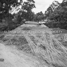
Negative - Photograph, J.A. McDonald, Eltham-Diamond Creek Road, 18 Sep 1959
Bridge construction Eltham-Diamond Creek road over the Diamond Creek (Wattletree Road), Eltham, September 1959 After some delay in receiving funds, work started on the bridge approaches in early September 1959. Traffic was still using the old bridge upstream. On Sunday, 20 September 1959, heavy flooding occurred in the stream and at 3:53 pm the old bridge was washed out. This photo was taken the Friday beforeRecord of various Shire of Eltham infrastructure works undertaken during the period of 1952-1962 involving bridge and road reconstruction projects, sometimes with Eltham Shire Council Project Reference numbers quoted. It was during this period that a number of significant improvements were made to roads and new bridges constructed within the shire that remain in place as of present day (2022). In many situations, the photos provide a tangible visible record of infrastructure that existed throughout the early days of the Shire. The album was put together by or under the direction of the Shire Engineer, J.A. McDonald.infrastructure, shire of eltham, bridge construction, 1959-09-18, bridge, diamond creek (creek), eltham, eltham north, glen park bridge, wattletree road bridge -
 Eltham District Historical Society Inc
Negative - Photograph, J.A. McDonald, Eltham-Diamond Creek Road, 18 Sep 1959
Bridge construction Eltham-Diamond Creek road over the Diamond Creek (Wattletree Road), Eltham, September 1959 After some delay in receiving funds, work started on the bridge approaches in early September 1959. Traffic was still using the old bridge upstream. On Sunday, 20 September 1959, heavy flooding occurred in the stream and at 3:53 pm the old bridge was washed out. This photo was taken the Friday beforeRecord of various Shire of Eltham infrastructure works undertaken during the period of 1952-1962 involving bridge and road reconstruction projects, sometimes with Eltham Shire Council Project Reference numbers quoted. It was during this period that a number of significant improvements were made to roads and new bridges constructed within the shire that remain in place as of present day (2022). In many situations, the photos provide a tangible visible record of infrastructure that existed throughout the early days of the Shire. The album was put together by or under the direction of the Shire Engineer, J.A. McDonald.infrastructure, shire of eltham, bridge construction, 1959-09-18, bridge, diamond creek (creek), eltham, eltham north, glen park bridge, wattletree road bridge -
 Halls Gap & Grampians Historical Society
Photograph - B/W, C 1880
This photo shows the first Delley's Bridge, built to cross the Fyans Creek to provide access to Halls Gap and beyond in the 1880's. The bridge was swept away a number of times in floods. This bridge was replaced by a higher timber structure but constant erosion of the creek bank eventually led to its replacement by a timber and concrete structure. After nearly 50 years of its use, wear and tear necessitated a fourth bridge to be erected in 2001.A log bridge across a creek with a man standing on the bridge. A woman in a white dress and hat is beside the creek and a man is standing near her on the bank. In the left background a house can just be seen through the trees.structures, bridges -
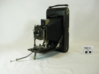 Hamilton Pastoral Museum
camera, Eastman Kodak, 1907
Google kodak manufactured from about 1900 to today No. 3 Cartridge KODAK Camera (metal front slide block focus) (Improved metal front, bed extension, longer bellow and rack pinion focus 1901) This item recorded pictorial information on the life and times of our society. advertising ,social events, news items ,scientific work, engineering ,medical field ,agriculture ,fires , famine, floods ,droughtkodak film camera. Leather look case, lens assembly with cable release folds out of case with expandable concertina lens.Name plate printed on assembly lens "EASTMAN KODAK / COMPANY/ ROCHESTER U.S.A." Printed on top of lens "KODAK / PAT / MAY 7 / 1907 / AUTOMATIC"pictorial, information, 1907, camera, kodak -
 Eltham District Historical Society Inc
Postcard - Photograph postcard, Old Bridge, Kaylock's Crossing, Brougham Street, Eltham, c.1912
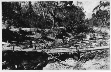
Date estimated to be circa 1912 based on the style of printing on the reverse of the card - Kodak Austral paper for real photo postcards, the paper was manufactured c.1908-1914 (See also POSTCARDS ON KODAK PAPER - IS IT POSSIBLE TO "DATE" THEM? http://tps.org.au/bb/viewtopic.php?t=115) Brougham Street was created in Josiah Holloway's 1851 subdivision of Little Eltham. It was one of several east-west streets shown on the subdivision plan as crossing the Diamond Creek. The western part was named Wellington Street on the subdivision plan but was later changed to conform with the name of the eastern part as acknowledgement of the continuity of the street. It is not known when the first bridge was constructed in Brougham Street however it was certainly mentioned at Council’s meeting of 2 June 1884 as being in a dangerous state of repair. This photo (c.1895) of an old bridge shows a very low-level simple log girder bridge crossing the creek at a right angle and so the approaches involved bends in the road alignment. This bridge was generally known as Kaylocks Bridge or Kaylock’s Crossing after the owner of the adjoining land. It was most likely built from around the mid-1850s, or a crossing of some fashion established as Richard George Kaylock, butcher of Little Eltham and his wife Emily Ann settled there in 1854. His property was in Wellington Street (now Brougham Street) and apparently extended across the Diamond Creek. The land on the western side of the creek was farmed, the house being on the eastern side. Kaylock's Bridge formed part of the original coach road to Eltham and in 1922 was described as an "old rustic bridge". Its low level and insubstantial construction made it susceptible to flood damage, necessitating frequent closures until repairs could be carried out. In September 1922, Council called for tenders for a new timber bridge to be constructed at Kaylock’s crossing. An engineering assessment carried out for the Council by Macleod Consulting at the time of the replacement suggested that the construction details indicate that it was in the 1900s, however this dating could possibly have been the result of numerous repairs undertaken over the years to flood damage. The tender was awarded to Mr Weller of Kangaroo Ground who commenced work in February 1923 on a higher-level timber trestle bridge. Work was slowed due to illness of the contractor and the accidental death of a man in March 1923 following the collapse of the bank after he had jumped into a hole that had just been blasted. The bridge was completed around July 1923 at which point the old structure was pulled up, marking what was described in the ‘Advertiser’ newspaper as the passing of an old and well-loved landmark in the district. In April 1924 the approach to Kaylocks bridge was washed away during the heavy flooding that destroyed the Main Road bridge. The western side was repaired, and an extra span was added to the eastern side using timber from the destroyed Main Road bridge. The bridge was again severely damaged four months later in August 1924 When a lack of finances delayed repairs to the Bridge Street bridge in 1931 (also referred to as Obelisk Bridge at the time), traffic had to detour via Brougham Street for some time. Local residents feared that the Bridge Street bridge might never reopen. Kaylocks Bridge was constantly subject to damage by floods. In the 1934 flood it was submerged by two feet of water. In more recent times the bridge was again severely damaged by flooding and repairs made. A new bridge and adjoining footbridge were constructed in 2009.Digital file only Postcards scanned from the collection of Michael Aitken on loan to EDHS, 2 Sep. 2022michael aitken collection, eltham, postcards, bridge, brougham street, diamond creek (creek), kaylocks bridge, wellington street -
 Eltham District Historical Society Inc
Photograph, Old Bridge, Kaylock's Crossing, Brougham Street, Eltham, c.1895
Brougham Street was created in Josiah Holloway's 1851 subdivision of Little Eltham. It was one of several east-west streets shown on the subdivision plan as crossing the Diamond Creek. The western part was named Wellington Street on the subdivision plan but was later changed to conform with the name of the eastern part as acknowledgement of the continuity of the street. It is not known when the first bridge was constructed in Brougham Street however it was certainly mentioned at Council’s meeting of 2 June 1884 as being in a dangerous state of repair. This photo (c.1895) of an old bridge shows a very low-level simple log girder bridge crossing the creek at a right angle and so the approaches involved bends in the road alignment. This bridge was generally known as Kaylocks Bridge or Kaylock’s Crossing after the owner of the adjoining land. It was most likely built from around the mid-1850s, or a crossing of some fashion established as Richard George Kaylock, butcher of Little Eltham and his wife Emily Ann settled there in 1854. His property was in Wellington Street (now Brougham Street) and apparently extended across the Diamond Creek. The land on the western side of the creek was farmed, the house being on the eastern side. Kaylock's Bridge formed part of the original coach road to Eltham and in 1922 was described as an "old rustic bridge". Its low level and insubstantial construction made it susceptible to flood damage, necessitating frequent closures until repairs could be carried out. In September 1922, Council called for tenders for a new timber bridge to be constructed at Kaylock’s crossing. An engineering assessment carried out for the Council by Macleod Consulting at the time of the replacement suggested that the construction details indicate that it was in the 1900s, however this dating could possibly have been the result of numerous repairs undertaken over the years to flood damage. The tender was awarded to Mr Weller of Kangaroo Ground who commenced work in February 1923 on a higher-level timber trestle bridge. Work was slowed due to illness of the contractor and the accidental death of a man in March 1923 following the collapse of the bank after he had jumped into a hole that had just been blasted. The bridge was completed around July 1923 at which point the old structure was pulled up, marking what was described in the ‘Advertiser’ newspaper as the passing of an old and well-loved landmark in the district. In April 1924 the approach to Kaylocks bridge was washed away during the heavy flooding that destroyed the Main Road bridge. The western side was repaired, and an extra span was added to the eastern side using timber from the destroyed Main Road bridge. The bridge was again severely damaged four months later in August 1924 When a lack of finances delayed repairs to the Bridge Street bridge in 1931 (also referred to as Obelisk Bridge at the time), traffic had to detour via Brougham Street for some time. Local residents feared that the Bridge Street bridge might never reopen. Kaylocks Bridge was constantly subject to damage by floods. In the 1934 flood it was submerged by two feet of water. In more recent times the bridge was again severely damaged by flooding and repairs made. A new bridge and adjoining footbridge were constructed in 2009. Part of a slide show presentation "Bridges & Waterways of the Shire" by Russell Yeoman to the 13 September 1989 Society meeting. The presentation included slides of historic photos from the Shire of Eltham Pioneers collections as well as several recent views.Photo of earliest known crossing of the Diamond Creek at brougham StreetPostcard photo printbrougham street, eltham, wellington street, kaylocks bridge, bridge, diamond creek (creek) -
 Kiewa Valley Historical Society
Photographs- 1 old black and white photograph of a wooden bridge over a river possibly Ryders Bridge in Tawonga. 2 –Enlargement of the original photograph showing the gentleman leaning on the bridge. Taken off the original photo
The bridge is not definitively identified, but is of similar construction style to other bridges built in rural areas around this time. Circa 1930”s and may be Ryders Bridge (Old Tawonga Bridge) which crosses the Kiewa River on Mountain Creek Rd Tawonga The first Tawonga bridge was built in 1884- destroyed by floods in 1916. New bridge constructed 1923 and destroyed in 1953. Present concrete bridge constructed in 1986 and named Ryders Bridge These wooden bridges were the only method for transporting stock and produce to market, transporting timber to the mills, sending and receiving mail and for local people to cross the many rivers in the area to go about their daily business. 1- Black and white photograph is glued onto heavy cardboard, which is yellowing with age. Top right hand corner has a tear in the cardboard. Photograph depicts a wooden bridge on wooden piles with 2 white wooden railings along the length of both sides. 2- Original photo has been digitally enlarged to show a gentleman in a light coloured suite and wearing riding boots leaning on the rails of the bridge. The bridge is not definitively identified, but is of similar construction style to other bridges built in rural areas around this time. Circa 1930”s may be Ryders Bridge (Old Tawonga Bridge) which crosses the Kiewa River on Mountain Creek Rd Tawonga bridge; tawonga bridge; kiewa valley -
 Eltham District Historical Society Inc
Slide, Site of proposed Yarra Brae Dam, Jul. 1973
With an increasing need to grow Melbourne's water supply, in 1973, the State Government announced plans for the development of Sugarloaf Reservoir. Two dams were to be built, one across the Yarra from the Yarra Brae property in Wonga Park to the Bend of Isles. Water was to be pumped from this dam to the higher level Sugarloaf Reservoir. The proposed extensive flooding of large numbers of properties resulted in significant community backlash and ultimately abandonement of the proposed Yarra Brae dam.35 mm colour positive transparency (x 3) Mount - Kodak Kodachrome Cardyarra brae dam