Showing 1442 items matching " lithographers"
-
 Glen Eira Historical Society
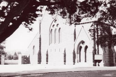
Photograph - St. Mary’s Church, Caulfield
Three photographs and one photocopied photograph of St. Mary’s Anglican Church Caulfield. All are undated and photographers are unknown. The first has paddocks in the foreground with the church in the distance. Also included are three lithographs of an architectural sketch of the proposed church from Illustrated Australian News 1870-1874, page 148.st. mary’s church, caulfield, reed and barnes, architects, caulfield, illustrated australian news -
 J. Ward Museum Complex
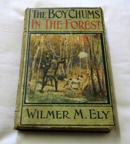
Book - Wilmer M. Ely 1910, The Boy Chums In The Forest; or, Hunting for Plume Birds in the Florida Everglades
"The story of the boy chums hunting the blue herons and the pink and white egrets for their plumes in the forests of Florida is full of danger and excitement. In this story is fully told how the chums encountered the Indians; their battles with the escaped convicts; their fight with the wild boars and alligators; and many exciting encounters and escapes. This is the third story of the boy chums' adventures." -- 1910. A.L. Burt. https://c.web.umkc.edu/crossonm/boychums.htmIn green cloth with a pasted-on colour lithograph illustration. Black and red titles with a black and white frontispiece. 304 pages. Book is in fair the boards show some use and shelf-wear. The front and back covers are worn with some staining and foxing. Corners are worn and holes in spine. Binding tight and text unmarked. Internally there is some light soiling. No Jacket. fiction"The story of the boy chums hunting the blue herons and the pink and white egrets for their plumes in the forests of Florida is full of danger and excitement. In this story is fully told how the chums encountered the Indians; their battles with the escaped convicts; their fight with the wild boars and alligators; and many exciting encounters and escapes. This is the third story of the boy chums' adventures." -- 1910. A.L. Burt. https://c.web.umkc.edu/crossonm/boychums.htmadventures, boys -
 Bendigo Historical Society Inc.
Map - MILLOO : COUNTY OF BENDIGO, 29-2-24
Map. Milloo, County of Bendigo. Wanurf, Dingee, Kamarooka, Pannoomilloo, Waranga Mallee Channel, Elmore to Kerang Road, Pannoo Estate. By authority A.J. Mullett, Govt. Printer. Photo-Lithographed at the Department of Lands and Survey, Melbourne, by W.J. Butson, 29-2-24. Price 1/-. Janiember to Rochester Road. (number 72 in map cupboard 1)A.J. Mullett, Government Printer.map, bendigo, milloo -
 Bendigo Historical Society Inc.
Document - COHN BROTHERS COLLECTION: BROWN MANILLA PAPER PARCEL
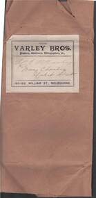
Brown manilla paper parcel bound with string. Handwritten on front Cohn Bros Victoria Brewery C Ltd 'Returns' Inside has printed paper sticker attached. From Varley Bros, Printers, Stationers, Lithographers, A c, 180-182 William St Melbourne. Handwritten addressed to Mr. E P Hastings Baring Chambers Market Street. bendigo, industry, cohn bros brewery -
Bendigo Historical Society Inc.
Map - DIGGORRA : COUNTY OF BENDIGO, 26-6-36
Map. Parish of Diggorra, County of Bendigo, Parish of Ballendella, Parish of Pannoobamawm, Pannoomilloo, Rochester West, Warragamba, Minto, Egerton, Elmore, Northern Railway to Echuca, Elmore and Cohuna Railway, Township of Elmore. By authority H.J. Green, Govt. Printer. Photo-Lithographed at the Deptartment of Lands and Survey, Melbourne. 26-5-36. (number 58 in map cupboard 1)H.J. Green, Govt. Printer.map, bendigo, diggorra -
Bendigo Historical Society Inc.
Map - BENDIGO AND DISTRICT PARISH MAPS, 21-10-26
Map. Sandhurst, County of Bendigo, City of Bendigo, Strathfieldsaye, Mandurang, Marong, Nerring, Borough of Eaglehawk, Township of Kangaroo Flat, Lockwood, Huntly, Epsom, Wellsford. By Authority H.J. Green, Government Printer, Photo-Lithographed at the Department of Lands and Survey, Melbourne bj W.J Butson 21-10-26,Price 1/-. (number 13 in map cupboard 1)By Authority H.J. Green, Govt. Printermap, bendigo, sandhurst -
 Tennis Australia
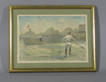
Page from Magazine, 1881
Framed page from unknown magazine. Reproduction of lithograph by J.W. Alexander depicting match at Staten Island between unknown players. Caption states: 'A GAME OF LAWN TENNIS, STATEN ISLAND CLUB GROUNDS - DRAWN BY J.W. ALEXANDER - SEE PAGE 653'. Number '23' handwritten on backing of frame. Materials: Ink, Paper, Wood, Cardboard, Metal, Glasstennis -
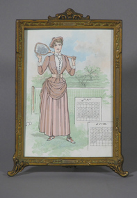 Tennis Australia
Page from book, Circa 1880
Colour lithograph advertisement for 'Ivory Soap'. Obverse features two pages of a calendar and woman standing with a racquet on her shoulder above text: 'IVORY SOAP/NEVER FADES SUMMER DRESSES'. Reverse features monochrome illustration of two women, one seated in hammock above text describing qualities of product. Materials: Ink, Paper, Metal, Painttennis -
 Kew Historical Society Inc
Plan - Subdivision Plan, Altyre Estate, 1920, 1920
Pru Sanderson, in her groundbreaking ‘City of Kew Urban Conservation Study : Volume 2 - Development History’ (1988), summarised the periods of urban development and subdivisions of land in Kew. The periods that she identified included 1845-1880, 1880-1893, 1893-1921, 1921-1933, 1933-1943, and Post-War Development. These periods were selected as they represented periods of rapid growth or decline in urban development. An obvious starting point for Sanderson’s groupings involved population growth and the associated economic cycles. These cycles also highlighted urban expansion onto land that was predominantly rural, although in other cases it represented the decline and breakup of large estates. A number of the plans in the Kew Historical Society’s collection can also be found in other collections, such as those of the State Library of Victoria and the Boroondara Library Service. A number are however unique to the collection.The Kew Historical Society collection includes almost 100 subdivision plans pertaining to suburbs of the City of Melbourne. Most of these are of Kew, Kew East or Studley Park, although a smaller number are plans of Camberwell, Deepdene, Balwyn and Hawthorn. It is believed that the majority of the plans were gifted to the Society by persons connected with the real estate firm - J. R. Mathers and McMillan, 136 Cotham Road, Kew. The Plans in the collection are rarely in pristine form, being working plans on which the agent would write notes and record lots sold and the prices of these. The subdivision plans are historically significant examples of the growth of urban Melbourne from the beginning of the 20th Century up until the 1980s. A number of the plans are double-sided and often include a photograph on the reverse. A number of the latter are by noted photographers such as J.E. Barnes.The Altyre Estate was advertised for sale by auction in 1920. A colour lithograph in the State Library of Victoria, in contrast to this monochrome version, notes the proximity of the subdivision to the Auburn Heights Bowling Club and to a range of transport options. The subdivision included fifty-one allotments as well as the original house ‘Altyre’ in Barkers Road. This version includes the amounts paid as deposit on a number of lots.subdivision plans - kew, altyre estate – kew (vic), barkers road – kew (vic), walsh street – kew (vic), ross street – kew (vic), loxton street – kew (vic), mount street – kew (vic), auburn heights bowling club, altyre -
University of Melbourne, Burnley Campus Archives
Plan, Burnley Gardens. City of Richmond. Parish of Jika Jika - County of Bourke, 1927
Plan showing Burnley Gardens - bounded by Swan St to N, Yarra River to E, Richmond Park on S and W side. Photo-lithographed at Dept of Lands & Survey by W.J. Butson. Plan shows old orchard, fowl sheds, coops and yards, milking shed, silo,nursery, glasshouse, fattening pens, gardens and orchards area in S.W. corner.burnley gardens, orchards, sheds, nursery -
 Bendigo Historical Society Inc.
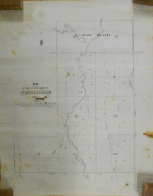
Document - MARKS COLLECTION: STRATHFIELDSAYE PLAN 1854
Plan drawn on light paper. Written on LH side of plan 'Plan of Part of the Parish of Strathfieldsaye 1854. Scale (shown) Lithographed at the Surveyor Generals Office, Melbourne July 10th. By I. Jones'. Plan shows Emu Creek and Village Reserve at top of plan, Shepherd's Creek on RH side, Parish Boundary Line on RH and bottom of plan.map, bendigo, shire of strathfieldsaye 1854 -
 Warrnambool and District Historical Society Inc.
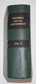
Book, Victoria and its Metropolis Vol 2, 1888
Information on the of Colony of VictoriaThe book has a green cloth cover with an indented pattern. The spine has gold printing on black cloth attached to the green cloth. The 820 pages are gilt edged and, to some extent, are water damaged. They contain printed text and lithographs .Some original pages relating to Warrnambool have been removed and replaced with photocopies which are pasted in. There are fold out coloured maps.non-fictionInformation on the of Colony of Victoria warrnambool history, history of victoria -
 Wycheproof & District Historical Society Inc.
Bunguluke Map, Bunguluke District In 1923, 27.2.1923
By 1881 Bunguluke was a small settlement as recorded, December 5, in the Charlton "Mercury". It reports that in that year Draper's Store, Hotel and Post Office and residence at Bunguluke North was totally destroyed by fire. For years now there has been little sign of community life with houses few and far between and acreages have gone into larger holdings. The map references land blocks and owners for that era.This important map shows the local land ownership and local features that existed in 1923. This is a photocopied black and white map of Bunguluke in the County of Kara Kara, Number L5149. Marked - Photo Lithographed by W.J. Butson 27.2.1923. The details include numbers of allotments, property owners, roads, rivers. The boundaries marked are the Parish of Jeruk, Parish of Wycheproof, Parish of Cooroopajerrup. Wycheproof township location is shown with the Scale of Chains. Bunguluke maps for other years are also in the collection.map, bunguluke, jeruk, wycheproof, cooroopajerrup -
 Bendigo Historical Society Inc.
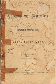
Book - BENDIGO SALEYARDS COLLECTION: THE BYE-LAWS AND REGULATIONS OF THE SANDHURST CORPORATION
Book with faded and stained pink cover. Much of the book held together with sticky tape. Titled The Bye-laws and Regulations of the Sandhurst Corporatiion, in connection with Local Government 1889. Printed by J. B. Young, General Printer, Book-Binder, Lithographer, &c., Lyttleton Terrace. Contained in the book are Regulations on buildings, parks, carriages, animals, noxious trades shops and tents.bendigo, council, cattle markets, bendigo saleyards collection - the bye-laws and regulations of the sandhurst corporation 1889, j b young, henry hattam, dugald macdougall, ebenezer neill, john buckley, j a woodward, w d c denovan, w g jackson, john delbridge, s h mcgowan, jacob cohn, j w colville, alexander bayne, d c sterry, john a woodward, patrick hayes, t jefferson conmnelly -
Bendigo Historical Society Inc.
Map - DIGGORRA PARISH : COUNTY OF BENDIGO, 6-9-21
Map. Parish of Diggorra, County of Bendigo, Parish of Bamawm, Rochester West, Pannoomilloo, Warragamba, Minto, Egerton, Elmore, Northern Railway, Parish of Ballendella. Elmore /Cohuna Railway. Photo-Lithographed at the Department of Lands and Survey, Melbourne by W.J. Butson, 6-9-21, Price 1/-.. By authority A.J. Mullett, Government Printer. (number 57 in map cupboard 1)A.J. Mullett, Government Printer.map, bendigo, diggorra -
 Tennis Australia
Page from Magazine, 1881
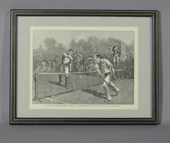
Framed page from unknown magazine. Reproduction of lithograph depicting match at Wimbledon in 1881 between Herbert Lawford & William Renshaw. Caption states" THE LAWN TENNIS CHAMPIONSHIP MEETING AT WIMBLEDON - THE FIFTH ROUND OF THE ALL COMERS' MATCH'. Artist's name appears in lower right corner: 'ARTHUR HOPKINS '81'. Materials: Ink, Paper, Wood, Cardboard, Metal, Glasstennis -
 Kew Historical Society Inc
Print, Jenny Rudolph, Kew
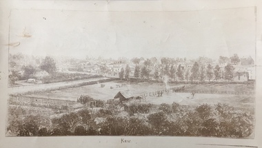
The point of view of the artist is looking towards Kew from the vicinity of Xavier College. The paddocks in the foreground are bordered by Wellington Street. In the distance the towers of the asylum can be see, further narrowing the date to after 1870s. The work exists in a number of original versions including a colour print.Kew, ca. 1870 - ca. 1880. Reproduction of a book plate from an original wood engraving, of an elevated view of trees and paddocks with a town in the background. The illustration is signed R. JENNY Sc. [Rudolph Jenny 1827-1905, lithographer.] A version from which this reproduction may have been made was donated to the State Library of Victoria by the National Trust, Victoria in 1985. kew (victoria), wellington street -- kew (vic.) -
 University of Melbourne, Burnley Campus Archives
Plan, Burnley Gardens. City of Richmond. Parish of Jika Jika - County of Bourke, 1927
Part-coloured plan showing drainage, sewerage drains, taps and waterstops. Area bounded by Swan St. To N, Yarra River on E and Richmond Park on SW side. Contour lines of orchard depicted, laying pens and yards. Coloured area depicts pavilion with surrounding garden and paths layout pencilled in. Photo-Lithograph by Dept. of Lands & Survey, Melbourne by W. Butsonsewerage, drainage, lithograph, pavilion -
University of Melbourne, Burnley Campus Archives
Plan, Burnley Gardens. City of Richmond. Parish of Jika Jika - County of Bourke, 1927
Plan showing Burnley Gardens - bounded by Swan St to N, Yarra River to E, Richmond Park on S and W side. Photo-lithographed at Dept. of Lands & Survey by W.J. Butson. Plan shows old orchard, fowl sheds, coops and yards, milking shed, silo, nursery, glasshouse, fattening pens, dairy, garden, orchards area in S.W. area.burnley gardens, orchards, sheds, nursery -
 Warrnambool and District Historical Society Inc.
Label, Modern Print, Early 20th century
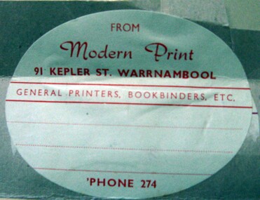
The Modern Print Company - engravers, lithographers, general printers , bookbinders and paper rulers- operated in Koroit Street Warrnambool. It was founded by Frederick Gaspar and Byron Laing in 1900. In 1904 the partnership was dissolved . The business continued in Koroit Street for the next 50 years. This label gives the address as Kepler Street which may have been an office outlet.This label is retained as a memento of a prominent printing business operating in Warrnambool in the early 20th century.An oval light grey label with red printing adhered to a grey piece of cardboard.FROM Modern Print 91 KEPLER STREET. WARRNAMBOOL GENERAL PRINTERS , BOOKBINDERS , ETC. PHONE 274gaspar's modern print company, warrnambool -
 Flagstaff Hill Maritime Museum and Village
Print - Lithoprint
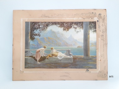
This art work is an example of an Art Deco print created through lithoprint / lithograph techniques. As a print it would have been more affordable than an original artwork and hence could be purchased by a wider cliental. Little is known about the artist, but Jean Lasalle is listed as producing another print used by Tuck & Sons in their Oilette postcard series.This item is significant socially as an example of artwork that may have been displayed in homes around the 1910s- 1930s. The Oilette logo carries significance, linking the print to a business that was influential in the early production of postcards.Unframed print on board with some framing tacks still attached to the back of the board. Print area is in fair condition. The print has been stuck to a ‘paper frame' which has been attached to the backing board. The subject of the print is a lake view, with steep mountains in the background and two female figures on a bench in the foreground in the Art Deco style. Colours are muted. The print has the artist's signature 'Jean Lasalle' (looking at the print bottom left) and the words 'Oilette' (looking at the print bottom right) with a small logo composed of an oval and square underneath.flagstaff hill, warrnambool, maritime village, maritime museum, flagstaff hill maritime museum & village, shipwreck coast, great ocean road, lithoprint, lithograph, oilette, golden dawn, art deco, jean lasalle, print, day dream -
Bendigo Historical Society Inc.
Map - REDESDALE : COUNTY OF BENDIGO, 24-12-24
Map. Redesdale, County of Bendigo, County of Dalhousie, Kimbolton, Langwornor, Spring Plains, Glenhope, Emberton, Metcalfe, Hawkestone, County of Talbot, Campaspe River, Back Creek, River Coliban, Lyell. By authority H.J. Green, Government Printer, Melbourne. Photo-Lithographed at the Department of Lands and Survey, Melbourne by W.J. Butson, 24-12-24, Price 1/-. (number 120 in map cupboard 1)H.J. Green, Government Printer, Melbourne.map, bendigo, redesdale -
Bendigo Historical Society Inc.
Map - AXEDALE, COUNTIES OF BENDIGO & RODNEY, 8-2-26
Map, Axedale, Counties of Bendigo & Rodney, Wellsford, Strathfieldsaye, Eppalock, Knowsley, Weston, Muskerry, Ellesmere, Town of Axedale, Longlea Railway Station, Axedale Railway Station, Wallan & Bendigo Railway. Campaspe River.Axe Creek. By authority H.J.Green, Govt. Printer. Photo-Lithographed at the Dept. of Lands and Survey, Melbourneby W.J.Butson 8-2-26. Price 1/-. (number 60 in map cupboard 1)H.J.Green, Govt. Printer.map, bendigo, axedale -
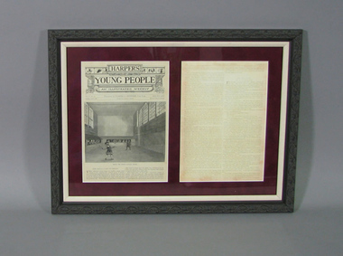 Tennis Australia
Page from Magazine, 03 Apr 1882
Front page from Harper's Young People magazine of April 3, 1883; and digital reproduction of reverse of same page mounted beside each other. Left folio features a lithograph entitled 'HENRY THE EIGHTH PLAYING TENNIS'. Also presents article entitled 'THE ROYAL GAME OF TENNIS'. Article continues on reprosuction of reverse of page. Materials: Paper, Ink, Metal, Wood, Glasstennis -
 Orbost & District Historical Society
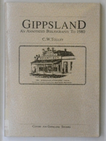
book, Gippsland Institute of Advanced Education, Gippsland An Annotated Bibliography to 1980, 1987
The Gippsland Institute of Advanced Education was established in September 1968. On its establishment, the institute assumed responsibility for the diploma courses previously offered by the Yallourn Technical College which had commenced diploma teaching in 1929. Initially, all the Institute's teaching was conducted in the diploma building of the Yallourn Technical College. In 1972 the Institute transferred part of its operations to the first of its permanent buildings on a large campus in rural surrounds near the township of Churchill south of Morwell. The Gippsland Institute of Advanced Education was opened on 20 November 1976. This book is a useful reference book for research into the history and establishment of Gippsland.A 232 pp plastic-covered soft covered book, The front cover is beige with the title, " Gippsland An Annotated Bibliography to 1980 C.W. Tolley" in black print at the top. In the middle is a black/white print detail from a lithograph of Bairnsdale Advertiser office in 1888. At the foot in black print is "Centre For Gippsland Studies". The book contains a list of books relating to the local social history , agriculture, indigenous, planning and resources . book-bibliography-gippsland gippsland-institute-of-advanced-education -
Bendigo Historical Society Inc.
Map - SUTTON GRANGE : COUNTY OF BENDIGO, 21-7-22
Map. Sutton Grange, County of Bendigo, County of Talbot, Mandurang, Sedgwick, Ravenswood, Hawkestone, Harcourt, Faraday. Myrtle Creek. Victorian Water Supply - Main Line of Aquaduct from Malmsbury to Sandhurst. By authority A.J. Mullett, Government Printer, Melbourne. Photo-Lithographed at the Department of Lands and Survey, Melbourne by W.J. Butson, 21-7-22. Price 1/-. (number 125 in map cupboard 1)A.J. Mullett, Government Printer, Melbourne.map, bendigo, sutton grange -
Bendigo Historical Society Inc.
Map - SUTTON GRANGE : COUNTY OF BENDIGO, 21-7-22
Map. Sutton Grange, County of Bendigo, County of Talbot, Mandurang, Ravenswood, Harcourt, Faraday, Hawkestone, Lyell, Sedgwick, Myrtle Creek, Victorian Water Supply - Main Line of Aquaduct from Malmsbury to Sandhurst. By authority A.J. Mullett, Government Printer, Melbourne. Photo-Lithographed at the Department of Lands and Survey, Melbourne by W.J. Butson 21-7-22. Price 1/-. (number 124 in map cupboard 1)A.J. Mullett, Government Printer, Melbourne.map, bendigo, sutton grange -
Bendigo Historical Society Inc.
Map - KNOWSLEY : COUNTY OF BENDIGO, 21-1-19
Map. Knowsley, County of Bendigo, County of Rodney, Weston, Crosbie, Knowsley, Dargile, Heathcote, Shingle Hut Creek, Sheep Station Creek, Forest Creek, Bendigo and Wallan Railway, Mt. Ida Creek. By authority A.J. Mullett, Government Printer, Melbourne. Photo-Lithographed at the Department of Lands and Survey, Melbourne by W.J. Butson 21-1-19, Price 1/-. (number 102 in map cupboard 1)A.J. Mullett, Government Printer, Melbourne.map, bendigo, knowsley east -
 Charlton Golden Grains Museum Inc
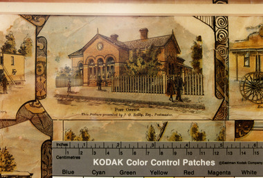
Photograph - Lithograph, Rider & Mercer, Views of Charlton
Charlton Post Office, High St, December 1891, built in 1879 to replace the original Post Office built in Camp St in 1878.Copy of Charlton Post Office High Street 1891 taken from the lithographs of Rider & Mercer. Possibly hand coloured. Brick building with three arched doorways and a clock above the central arch. Picket fence. One person standing in front of the building, a man walking past and a couple walking past a gate. Ruler showing in lower part of photo with KODAK Colour Control Patches written on it.Post Office. This picture presented by J. G. Reily, Esq., Postmastercharlton, charlton post office, business, industry, lithograph -
 Melbourne Tram Museum
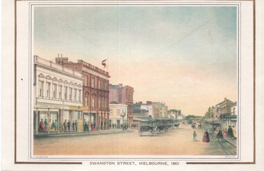
Artwork, other, Swanston Street Melbourne 1863
Colour print of a reproduction of an oil painting - Swanston Street from a point north of Little Bourke St looking south towards the Kings Domain. Reproduced by Kew Cottages and St Nicholas Parent's Association from a original print and lithographed by F Cogne, printed and published by Charles Troedel in his Melbourne Album 1863. Appears to have a number of horse drawn cabs parked in the centre of the street.Yields information about early Melbourne after the start of the gold rush.Reproduction of an oil painting - card - Swanston Street Melbourne 1863melbourne, horse drawn vehicles, swanston st