Showing 915 items
matching railway park
-
 Parks Victoria - Mount Buffalo Chalet
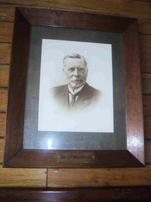
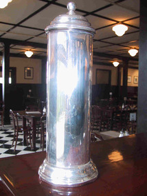
Photograph, " DR J.F.WILKINSON"
'There are also a number of framed portraits, including those of...Dr. John Wilkinson, a doctor who started a practise in Bright in the late 1880's and helped develop the tourist potential of the Mount Buffalo Plateau. " (Pg 84, Historica, 2011) Dr John .F. Wilkinson was a significant figure in the pioneering of tourism at Mt Buffalo. A Doctor and resident of Bright, he and W.A. Staker were the founder members of the Bright Alpine Club formed in 1887 to promote the natural attractions of the Buffalo plateau. " They form the Alpine Club and charge a membership fee for guiding people up the mountain (led by official guides Bill Weston and Edward Carlisle). this is matched by a grant from the local shire council.... They advertise in the Argus and promote the Australian Alps, Bright district as "The Switzerland of Victoria'. Mt Buffalo, with the railways nearby, is the most accessible snowfield and becomes 'the cradle of skiing in Victoria'." (Pg 179 Historica . 2011) The initial funds raised by the Alpine club funded the Staker's walking track, the first easily accessible route up the mountain. . They engaged the services of early Victorian photographer Nicholas Caire, whose scenic photographs helped to promote the beauty of the mountain. The efforts of these gentlemen culminated in securing 2.800 acres for the one of the first National Parks in Victoria, 1898. Listed in Draft Inventory of significant Items. Framed sepia photograph. Grey mount in wooden frame. Portrait of Dr.J.F Wilkinson. Brass name plaque at base of frame. Hand finished / highlighted in places." DR J.F.WILKINSON" -
 Parks Victoria - Mount Buffalo Chalet
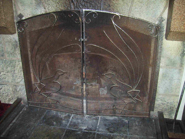
Firescreen and poker
'The distinctive lyrebird firescreen has become a popular feature of the lounge. It is not known how long it has stood in this position, but it appears to have been custom-made for the fireplace. Firescreens are not clearly shown in early photographs. It is popularly believed that the fenders on the floor..came from the Victorian Railways workshops and were made from railway line metal..' (Pg 72 Historica. 2011) "In 1924 amateur naturalist and mountain-guide, Alice Manfield (18-78 -1960) popularly known as Guide Alice, released 'The Lyre-birds of Mount Buffalo', a 23 page booklet detailing her studies into the lyre-birds on Mount Buffalo, the first pictorial record of lyre-birds to be published.... It is not known whether the lyrebird fire screen in the Chalet Lounge was dedicated to Alice Manfield and her study into local lyrebirds, but this popular feature is a most appropriate tribute." (Pg 132 Historica,2011) Listed in Draft Inventory of Significant Collection Items . 1. Forged and beaten steel firescreen. opens in the centre and is closed with two latches. One lyre bird design on each side. Heavy mesh with scrolling work. Attached to fireplace. 2. Poker is forged steel with a knob on one end and a hook on the other. -
 Parks Victoria - Mount Buffalo Chalet
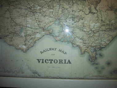
Map, "Railway Map of Victoria"
Large framed map of Victoria, showing Victorias extensive rail network. Printed by Victorian Railways and is one of a number of 'framed pictures, particularly photographs of scenery, which have always been a feature of the Chalet.' (Pg 83. Historica, 2011) This map has been a permanent fixture situated in the hallway alongside the ballroom leading to the ski hire area since the 1950's and most likely earlier. Listed in Draft Inventory of Significant Collection ItemsLarge railway map of Victoria, Melbourne & Ballarat framed in white painted wood. Scale eight miles to one inch. Areas of the map have been whited out.Yes -
 Parks Victoria - Mount Buffalo Chalet
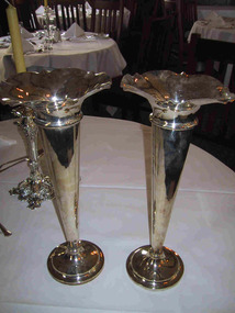
Vase
Silver plated vase which was part of the Dining room silver service settings . 'When the Victorian railways took over managemen of the Chalet from 1 october 1924, they ran their dining room and cafe in similar fashion to the dining cars on their trains and refreshment rooms on their stations, using the same ceramic hotel-ware and electro plated nickel silverware (EPNS), all made to order items that are clearly idenitified by the distinctive 'VR' monogram. The Chalet retains a good selection of of the diverse range of EPNS item formerly used in the dining room..- which in all their variety and function help to interpret the dining room protocols of the 'tourist house' and the service provied by the Victorian Railways refreshment and Services Branch. Many of the items were manufactured by by Stoke & Sons of Melbourne (est. 1856.' (Pg 103. Historica) Listed in Draft Inventory of Significant Collection items. Appendix A.3.Tableware. (Pg 166 Historica).Two fluted electroplated silver vases with Victorian Railways insignia and a number at base."VR" and more... -
 Parks Victoria - Mount Buffalo Chalet
Container
Straw container, original to the Cafe, which supplied afternoon teas and suppers to casual visitors and Chalet guests. Spiders and milkshakes were popular with yung guests after evening tournaments, films and concerts. 'When the Victorian railways took over managemen of the Chalet from 1 october 1924, they ran their dining room and cafe in similar fashion to the dining cars on their trains and refreshment rooms on their stations, using the same ceramic hotel-ware and electro plated nickel silverware (EPNS), all made to order items that are clearly idenitified by the distinctive 'VR' monogram. The Chalet retains a good selection of of the diverse range of EPNS item formerly used in the dining room..- which in all theoir variety and function help to interpret the dining room protocols of the 'tourist house' and the service provied by the Victorian Railways refreshment and Services Branch. Many of the items were manufactured by by Stoke & Sons of Melbourne (est. 1856.' (Pg 103. Historica) Listed in Draft Inventory of Significant Collection items. Appendix A.3.Tableware. (Pg 166 Historica).Electroplated silver drinking straw container. Tube shape. Moulded circular base with matching lid with central post which can be pulled up to reveal drinking straws resting on it.On front, "VR / Straws" Also silver stamp on base and inscription;"Parmount / plate / best / EP A1 NS / quality / warranted / hardsoldered / K. G. LUKE / MELB / 6889" -
 Parks Victoria - Mount Buffalo Chalet
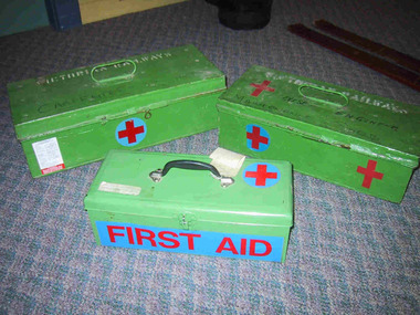
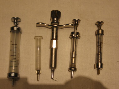
Cases, first aid
Used at the Chalet or by the Victorian Railways for administering first aid. 'A range of first aid supplies, including older types of stretchers and syringes emphasise the importance given over the years to emergency equipment and to the need for remedial items such as bedpans and invalid cups.' (Pg 110. Historica) For many years whilst under Railways Management the First Aid Room was opposite the stairs leading down to the Café, on the left hand side leading up to the Dining Room. Here skiing and recreational injuries were attended to.Listed in Draft Inventory of Significant Collection items. Appendix A.3.Staff Equipment. (Pg 167 Historica).Seven green painted tin first aid cases with hinged lids. Two cases have "Victorian Railways"stamped on them. All have a blue circle with a redcross marked on them.Yes -
 Parks Victoria - Mount Buffalo Chalet
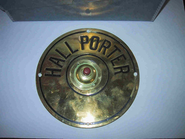
Bell
Was attached to a wall near reception but was removed to storage in approx.. 2000 - 2002. The bell has strong associations with the Victorian Railways Era reflecting the service and ethos of Railways with its uniformed Porters welcoming and on duty as Night Porter and day for all guests needs. (Especially lost keys) assistance with luggage, room service and co-ordinating transit and transport with Railways buses and services. A personal recollection is of Joseph the Night Porter welcoming and assisting when as a family with four sleeping children we would arrive after midnight to the Chalet where rooms would be ready, beds turned down and all unpacking of the car supervised by Joseph. (J. Skeggs) "A number of specific items, which have been useful in the day to day operations of the Chalet, remain in the building with each complementing the other to provide context ,meaning and character to their setting. Items such as the hall porter bell, the many signs providing information to the guests, the wall clock, barometer and dinner bell point to the Chalet being a well-run social institution with a pleasant environment for rest, recreation and congenial company." (Pg 81 Historica, MBCC) Listed in Draft Inventory of Significant Collection items A.3 Fixtures and Fitttings. (Pg 165. Historica MBCC)Circular brass disc with inner (separate ) maroon button mounted in raised circular disc. Hall Porter is embossed with black colouring around half of outer, larger disc."HALL PORTER" -
 Parks Victoria - Mount Buffalo Chalet
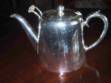
Teapot
Original Victorian Railways teapot, part of the silver service at Mt Buffalo Chalet. Part of Victorian Railways silver service. When the Victorian railways took over management of the Chalet from 1 October 1924, they ran their dining room and café in similar fashion to the dining cars on their trains and refreshment rooms on their stations, using the same ceramic hotel-ware and electro plated nickel silverware (EPNS), all made to order items that are clearly identified by the distinctive 'VR' monogram. The Chalet retains a good selection of the diverse range of EPNS item formerly used in the dining room..- which in all their variety and function help to interpret the dining room protocols of the 'tourist house' and the service provided by the Victorian Railways refreshment and Services Branch. Many of the items were manufactured by Stoke & Sons of Melbourne (est. 1856.)' (Pg. 103. Historica) Possibly once graced the chrome display cabinet.Listed in Draft Inventory of Significant Collection items. Appendix A.3.Tableware. (Pg 166 Historica).Large electroplated teapot with "VR" engraved on one side. Handle features holes at base either end of join. Lid features a circular knob and scroll handle at front with a wooden insert. Teapot has flat wide circular base."EPNSSRS / MADE IN AUSTRALIA / STOKES & SONS / MELBOURNE / BOOMERANG PLATE / WARRANTED / HARD SOLDERED / 745 / VICTORIAN RAILWAYS" -
 Parks Victoria - Mount Buffalo Chalet
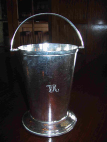
Bucket, ice
Part of the Victorian Railways silver service. When the Victorian railways took over management of the Chalet from 1 October 1924, they ran their dining room and cafe in similar fashion to the dining cars on their trains and refreshment rooms on their stations, using the same ceramic hotel-ware and electro plated nickel silverware (EPNS), all made to order items that are clearly idenitified by the distinctive 'VR' monogram. The Chalet retains a good selection of of the diverse range of EPNS items formerly used in the dining room..- which in all their variety and function help to interpret the dining room protocols of the 'tourist house' and the service provided by the Victorian Railways refreshment and Services Branch. Many of the items were manufactured by Stoke & Sons of Melbourne (est. 1856.)' (Pg 103. Historica) Possibly once graced the chrome display cabinet.Listed in Draft Inventory of Significant Collection items. Appendix A.3.Tableware. (Pg 166 Historica).Small ice bucket. Electroplated silver on nickel. Has a handle to carry and wide pedestal base."VR" insiginia engraved on front of bucket.Crown with scroll underneath with "Victorian Railways" Under that,"WHITE - THROUGH / E.P \ A1\ N.S" -
 Parks Victoria - Mount Buffalo Chalet
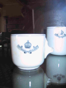
Cup
Part of Victorian Railways crockery. 'When the Victorian railways took over management of the Chalet from 1 october 1924, they ran their dining room and cafe in similar fashion to the dining cars on their trains and refreshment rooms on their stations, using the same ceramic hotel-ware and electro plated nickel silverware (EPNS), all made to order items that are clearly idenitified by the distinctive 'VR' monogram. . ..The Chalet Collecton also incudes items of ceramic stoneware... and these too interpret the function and role of the dining room. The ceramic items items were generally manufactured by 'Grindley' or 'Grafton'... Ceramic ware used at the Chalet from the 1920's to the 1950's had a black VR monogram or badge and was the same crockery used in th VR dining and buffet cars. Crockery used in the VR refreshment rooms had a red monogram." (Pg 104. Historica)' Listed in Draft Inventory of Significant Collection items. Appendix A.3.Tableware. (Pg 166 Historica).Small coffee cup with Victorian Railways in scroll design with a crown motif above scroll. White china with black transfer design. Mark and inscription on base. Handle is broken, cup cracked. Cup possibly broken during removal to Bright in 2005. also two teacups of the same design and inscription. Both have handles but both are cracked.-On base,"DURALINE / SUPER /VITRIFIED / GRINDLEY / HOTEL WARE Co / ENGLAND / 3-41 " On front of cup,"VICTORIAN RAILWAYS" -
 Parks Victoria - Mount Buffalo Chalet
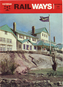
Magazine, "Victorian Railways November 1974"
'Over the years the VR Advertising Division published a number of booklets promoting Mount Buffalo's sports and restorative powers of its scenery in summer and winter...The collection (MBCC) comprises a good range of tourist writing published as promotional booklets, guidebooks, brochures, walking trails, maps and newspaper articles.' (Pg. 119. Historica) This Victorian Railways monthly publication and also the VR Newsletter, published by the Victorian Railways Printing Works in North Melbourne, is one of a number which featured iconic photos of the Chalet of the plateau on its cover, as an identifiable flagship for The Victorian Railways and it's employees from the Railways Refreshment and Services Branch. These publications also have stories regarding upgrades and on long serving staff of the Chalet.Listed in Draft Inventory of Significant Collection Items . Appendix A.3. Promotional material.. (Pg 168. Historica).Railways magazine featuring an image of the chalet on the front cover and an article about the Chalet.Yes -
 Parks Victoria - Mount Buffalo Chalet
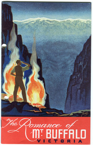
Booklet, "The Romance of Mt Buffalo Victoria"
Published by the Victorian Railways around 1929. "Over the years the VR Advertising Division published a number of booklets promoting Mount Buffalos winter sports and the restorative powers of its scenery in summer and winter." (Pg 119. Historica) This booklet provides a brief history of the Chalet and features excerpt from a speech by Dr Wilkinson. The beautiful graphic illustrates a tale of the Manfield brothers communicating nightly by fires to family in the valley. The artist is possibly James Northfield or Percy Trompf, whose lithographic posters and promotional material for the Railways were iconic of the time and promoting tourism in Australia was an important National enterprise. Listed in Draft Inventory of Significant Collection Items . Appendix A.3. Promotional material.. (Pg 168. Historica)."The Romance of Mt Buffalo" a brief history of the chalet from an address given by Dr. J.F. Wilkininson in Feb 1929. The booklet has a coloured cover depicting the Gorge at night with a man standing with two camp fires. x 2.Yes -
 Parks Victoria - Mount Buffalo Chalet
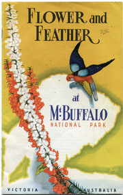
Booklet, "Flower & Feather at Mt Buffalo National Park Victoria, Australia"
H.C.E. Stewart , who first visited the plateau in 1919, produced the booklet, Flower and Feather, the Chalet has two copies. Published in the 1950's by the Victorian Railways Public Relations and Betterment Board, it is still an accepted guide on the the mountain bird's annd plants." (pg 132. Historica) The writer first visited Mt Buffalo in 1919 - & then after the war he decided to show all the unique flowers of Mt Buffalo through this book.Listed in Draft Inventory of Significant Collection Items . Appendix A.3. Natural History. (Pg 169. Historica).2 x Yellow & white books with an eastern Rosella and a red & white flower on it. 21 pages of text & photos. Front page has a picture of an Eastern Rosella and flower, the Melbourne Bay. (.2 has holes punched in it.Yes -
 Parks Victoria - Mount Buffalo Chalet
Syringes
'A range of first aid supplies, including older types of stretchers and syringes emphasise the importance given over the years to emergency equipment and to the need for remedial items such as bedpans and invalid cups.' (Pg. 110. Historica) For many years whilst under Railways Management the First Aid Room was opposite the stairs leading down to the Café, on the left hand side leading up to the Dining Room. Here skiing and recreational injuries were attended to.Listed in Draft Inventory of Significant Collection items. Appendix A.3.Staff Equipment. (Pg 167 Historica).Syringes: from .01 till ..04 they have a scale ,they are made with Glass, .01 5ml .02 1ml, .03 20ml, .04 22ml, .05 are made with metal..01 British made 200`C, Everett .02 Gima .03 JJEFF, record british make original .04 original record .05 W.G.LTD Sydney -
 Parks Victoria - Mount Buffalo Chalet
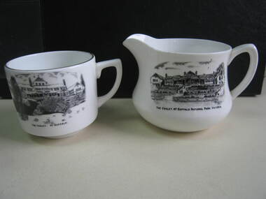
Crockery
The jug and cup were purchased from a second - hand shop in Bairnsdale. Jug is older than cup as the chalet is represented as a single storey structure. The cup is later as the second storey appears in the illustration. 'Souvenirs in relation to the Chalet and Mount Buffalo wee first mention in December 1912... A large range of souvenirs has since been associated with the Chalet and Mount Buffalo from crafted wooden items, silver spoons, cups etc... The collection includes a broad selection of products that have been sold throughout much of the Chalet's history, each representative of the transient fashions of their period.' (Pg. 114. Historica) 'A group of tableware items is notable for its black transfer printed decoration, which features the Chalet building. Interestingly, the printed designs represent the Chalet at two different stages in its building history under the Victorian Railways, in 1926 after completion of the north wing, and 1937-39, after the second storey is added to the front.. manufactured in England by A.B. Jones and sons, a Stoke on Trent pottery firm which operated under the trade name of Grafton China between 1900-1972.' (Pg. 114. Historica)Listed in Draft Inventory of Significant Collection Items . Appendix A.3. Souvenirs. (Pg 168. Historica)..1] Ceramic jug. Souvenir of Mt Buffalo. White ceramic squat milk jug with a black transfer illustration/drawing on front side. Picture is of the MtBuffalo Chalet from the front. Some worn gold glaze detail. It appears to be a single story building with a planted garden at the front with a fence. Trees to one side and people walking up steps. "THE CHALET, MT BUFFALO NATIONAL PARK, VICTORIA." is written under the illustration. Jug has a faint crack. .2] White ceramic cup with gold edging around top of cup. Black transfer drawing of the chalet with a second storey. Rocks and tree in foreground and "THE CHALET. MT BUFFALO." underneath transfer. .1] "THE CHALET, MT BUFFALO NATIONAL PARK, VICTORIA." is written under the illustration. On the base of the jug, with sun motif, "ENGLAND / GRAFTON CHINA /A / B J / & SONS / LOFTUS MORA / PTY. LTD" .2] "THE CHALET. MT BUFFALO." underneath transfer. Under cup, "A.B.J. / GRAFTON / CHINA / MADE IN / ENGLAND" -
 Truganina Explosives Reserve Preservation Society Inc (TERPS)
Digitised Oral History – Truganina Explosives Reserve - Tape 7 Cliff Gibson, 2018
The interviews were recorded in 2000 by Bronwen Gray and Alan Young for the production of Unreserved, Stories from Truganina Explosives Reserve, animated stories from past residents, workers and interested people of the Reserve (subject to copyright 2004). Cliff Gibson, a Williamstown resident, discusses the handling and shipping of explosives in the Port of Melbourne between 1863 to 1962 and the establishment, development and history of Truganina Explosives Reserve. In the interview he mentions the names of the Lighters and Ships used to transport the explosives to and from the Truganina Explosives Reserve. A primary source of information on memories of the Truganina Explosives Reserve and Altona,Victoriaexplosives, lighter, sailing lighters, the brig martha, deer park, australian chemical company, nobel explosives company, ici, james scott and company, jacks magazine, william wardell, george thomas chirnside, 1897, 1901, pier, bill grant, james mullins, 2 foot gauge tramway, explosives trucks, explosive magazines, railway explosives vans, queen street, richard rendle holten, ports and harbours, the lighter truganina, the lighter george stone, rose, mary jane, tarniet, derrimut, boonah, deutgam, naval dockyards williamstown, charlie curry, powder barges, cargo net, alma doepel, huia, wongalla, joseph sims, argonaut, maryland, pirie, lady isobel, taranui, point wilson, failee, captain dyson, hector pirie -
 Parks Victoria - State Coal Mine - Wonthaggi
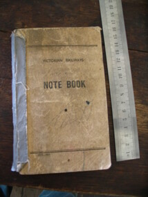
Notebook, "Victorian Railways Notebook", C 1950's
Notebook used to record bags of horse feed at the different mine areas.Dirty brown cardboard cover, grey binding tape on spine. Black text on front cover.Victorian Railways. Notebook 1875-49 -
 Parks Victoria - State Coal Mine - Wonthaggi
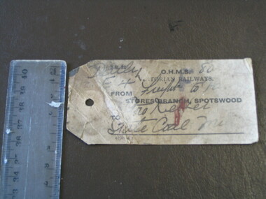
Ticket, Victorian Railways
Railway luggage ticket to ensure that luggage reaches its destination which is the State Coal Mine.Small used railway luggage ticket with inscriptions.Yes -
 Parks Victoria - Gabo Island Lightstation
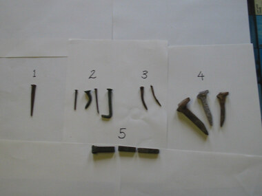
Nails
The five types of nails include a stamped steel nail made for wooden flooring; four copper nails used for boat building found at various locations on the island; two steel nails removed from the lantern room door during restoration in 2002 which possibly came with the Chance Bros. lantern room kit delivered in 1862; three galvanised steel nails used to pin the railway track to sleepers and decking on the jetty (the rail track carried a small trolley for unloading stores from supply ships); and a square copper nail found on the rocky shore on Tullaberga Island close to the location of the Monumental City wreck of 1853. The huge American steamer, Monumental City, was wrecked on 15 May 1853. Built in 1850, the ship was the first screw-propulsion steamer to cross the Pacific and was heading back to Sydney after dropping off Californians heading for the Victorian goldfields. Thirty-seven lives were lost, including the owner of the ship, Peter Strobel. A medal was awarded by Sydney residents to Charles Plummer who swam ashore with a line from the wreck. The tragedy renewed the urgency for a lighthouse on Gabo Island, and in 1862 when this was achieved an obelisk was erected as a memorial to those who perished. That year, Victorian PWD architect and designer of the lightstation buildings, Charles Maplestone, gave the following instructions: ‘You may remove the remains of the poor unfortunate shipwrecked of the Monumental City to the site on Gabo you propose but take scrupulous care to collect all the remains and inter them decently under the monument. Pray save any relics’.246 Heritage Victoria has 39 artefacts listed under the Historic Shipwrecks Act (S473) with a clear provenance to the Monumental City. While the copper nail has no documented provenance, it still has contributory significance as part of a diverse assemblage of relics that help to interpret the history of the Gabo Island Lightstation and the numerous shipwrecks that have occurred in its vicinity since the mid nineteenth century..1 Steel nail - flat. Stamped. This type of nail was used for secret nailing of flooring. Source of this nail is unknown. .2 Copper nails. This type of nail was used for boat building. Found at various locations around island. .3 Steel nails. Extracted from lantern room door during restoration 2002. .4 Galvanised steel nails. Used to pin railway track to timber sleepers and decking on jetty. Rail track carried a small trolley used during the unloading of stores from supply ships. .5. Copper nail square. This nail was found on the rocky shore line on Tullaberga Island close to the location of the wreck of the "Monumental City" wrecked May 1853. Nail found in June 2000. -
 Parks Victoria - Maldon State Battery
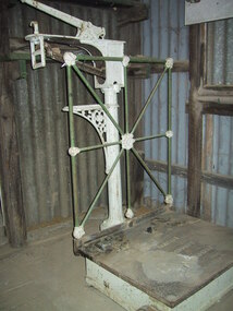
Scales, platform
Similar to railway platform scales and may have been relocated from the nearby Maldon Railway station. The history of its use at the battery is unknown.Large cast iron platform scale, white painted base with 2 wheels. The cast iron plate sits on top of a base with an inscription. There is white and green floral decoration on the frame, which is attached to the base. The white decorative stand with tray and weight measure attached has an inscription.base- "W. & T. Avery Ltd/makers/London &/Birmingham". Platform- "W. & T. Avery Ltd. Weight measure- LB 14 12 10 8 6 4 2" -
 Park Orchards Community House
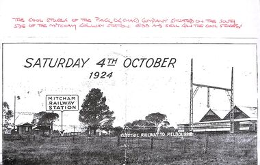
Photocopy, Photo of the location of the Park Orchards Company cool store, on south side of Mitcham Railway Station, 1924
-
 Wodonga & District Historical Society Inc
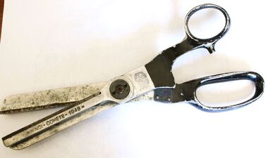
Functional object - Large Pinking Shears, Comete Ninci, 1948
Pinking shears or scissors were a valuable accessory for any professional or home dressmaker. Pinking shears have serrated edges and they leave trimmed fabric with a decorative edge as well as preventing the fabric from fraying. The words under the trademark "Marque Depose" mean trademark pending. These pinking shears were owned by Mrs. Betty Sheather of Gordon Street, Wodonga, Victoria. Betty was the daughter of James and Elizabeth Fletcher. Her father had many jobs including carriage cleaner with Victoria Railways at Wodonga and her mother was at House Creek State School No. 2266. Betty worked in Arnold's Store, the store of Costelloe & Smith as well as the Bethanga Park homestead as well as Drummonds at Walwa and the Hotel at Ebden. As a younger woman she lived with the Whan family at Stonleigh which was then a rope factory.Betty was a keen golfer and belonged to a club which played at the Wodonga Racecourse and was a member of the Bandiana Golf Club. These shears were owned by a well-known member of Wodonga and were representative of dressmaking implements used in the mid 1900s.Large vintage Comete Pinking Shears / zigzag scissors produced in Italy from metal alloy.On outer side of blade : NINCI COMETE 1948. Beside central hinge in ring shape: COMETE/ITALY/NINCI/ MARQUE DEPOSE.pinking shears, dressmaking -
 Wodonga & District Historical Society Inc
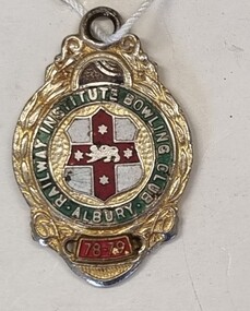
Badge - Railway Institute Bowling Club Albury 1978 - 79
The New South Wales Railway Institute affectionately known as “the Institute”, was initially established to provide a higher standard of educational learning for NSW railway employees. As well as employment related training, the Institute was tasked with stimulating growth and intellectual development of employees in the arts, social, leisure, and physical recreations. The NSW Railway Institute was formally opened on the 14th of March 1891 and at the time was the only institution of its kind in the Commonwealth. The Albury branch of the Railways Institute was formed on March 1, 1921. This included the building of a Railway Institute building as part of the Railway precinct in 1921. On Tuesday 7 October 1952, the Daily Advertiser, Wagga reported that a move had started at Albury for the establishment of a third bowling club. The new club formed would be the Railway Institute Bowling Club and the suggested site was on Albury City Council land at the corner of Young and Smollett streets. The Albury Railway Institute opened its bowling greens in February 1956. It later became known as Windsor Park Bowling Club. In 2003, the Bowling Club was liquidated and was amalgamated with the Albury Soldiers Sailors & Airmen’s Club. After changes to their operating model, the club building was demolished in 2013. This badge is representative of the role played by the NSW Railway Institute for its members and its involvement in the broader community.Member's badge for the Railway Institute Bowling Club Albury. A small metal badge with enamel finish depicting the logo of the club in green, red, gold and white.Around the central logo "RAILWAY INSTITUTE BOWLING CLUB ALBURY/ 78-79"railway institute, bowling clubs, social activities albury -
 Wodonga & District Historical Society Inc
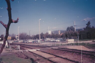
Photograph - Fred Rochow Railways Collection - Employees' car park at Wodonga, 23 August 1988
... Employees' car park at Wodonga Railway Yards with train... Railways Wodonga Railway employees Wodonga Employees' car park ...The Fred Rochow Railways Collection incorporates photos related to the operation of the Wodonga Railway Station including different types of trains and railways staff C. 1930 – 1990. It was donated to the Wodonga Historical Society by Fred Rochow, a railwayman who spent many years based in Wodonga. He joined the Victorian Railways on 17th June l947 and retired in 1988. For some time, he was a member of the Australian Federated Union of Locomotive Enginemen and served a term as a member of the Trades Hall Council. He had an extensive knowledge of the struggles that took place to achieve better conditions for railway workers. Fred worked for many years as a fireman and then worked his way up the ranks to driver, experiencing many changes from the days of steam locomotives through to diesel trains, locomotives and even the modern XPT train. He worked throughout Victoria at different stages of his career, with his final working years focused on the northeast of Victoria and the Albury to Melbourne line. After his retirement, Fred continued to share his love of steam miniature trains with the community.This collection has local and statewide significance as it captures images of trains, locomotives and personnel who operated the railway services in Wodonga and throughout Northeast Victoria. The railways played a critical role in opening up Victoria and connecting Australia for trade, business, social communication and transport.Employees' car park at Wodonga Railway Yards with train tracks in the foreground. The railway yards and the railway tracks ran through the middle of Wodonga from its opening on 21 November 1873 until it was closed on 9 November 2008. On 25 June 2011 a new station opened on the northern edge of the town.fred rochow, victorian railways wodonga, railway employees wodonga -
 Wodonga & District Historical Society Inc
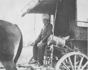
Photograph - Sikh Hawkers in Wodonga
Sikh hawkers were a regular sight throughout the Wodonga and Upper Murray district in the early 20th century. The regular visitors to the area included Pola Singh and Gambil (Gamble) Singh. Gamble Singh often camped on McKoy’s Moorefield property in West Wodonga and several other places around the district. Gamble was also a horse breeder and had several draught horses to pull his wagon. Like many of the hawkers he worked hard to send money back to support family in India. He apparently returned to India about 1950, but left some money in the Bank of NSW in Wodonga in case he returned. He allegedly died soon after and the money was eventually able to be claimed by his nephews in India. A small overlooked park in Wodonga is named the “Gamble Singh Park” in his memory. J. Flanagan who operated the Halfway Hotel commented on having as many as seven or eight bullock teams “yoked” overnight to the fence outside the hotel as well as 100 or more Indian hawkers – led by the fondly known Pola (Pollah) Singh. The hawkers returned to Wodonga annually to renew their hawkers’ license and camped on the flats, or also came to Wodonga to collect orders at the railway station to stock up their supplies. Pola Singh was often based at the Colac Colac reserve near Corryong and had on board his compatriot Isar Singh. He often acted as an intermediary between the individual hawkers and the authorities. Unfortunately, it was Pola’s habit to walk in front of his wagon at the start of each day. On the morning of 23 June 1923 his horses were restive and hard to control. They took flight and ran Pola down on the road near Cudgewa. He was rushed to the Corryong Hospital but died there a few days later, aged 65. Pola was cremated, with some of his ashes scattered in the Murray River and some returned to his homeland to be scattered in the Ganges River. His cremation was listed in the Obituary page of the Weekly Times, Melbourne on Saturday 14 July 1923. A small memorial to Pola Singh is located in the Corryong Cemetery.These images are significant because they help to document the history of the Sikh Hawkers who plied their services to Wodonga and throughout rural Australia in the late 19th and early 20th centuries.A collection of black and white images featuring Sikh Hawkers Gamble Singh and Pola Singh take in the Wodonga area.indian hawkers, sikh hawkers, gamble singh, pola singh -
 City of Kingston
Photograph - Black and white, Public Transport Corporation, c. 1960
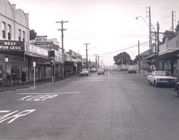
This image is part of a larger collection of images from the Public Transport Corporation displaying train stations and streetscapes in what is now the City of Kingston.Black and white photograph depicting the run in to the level crossing at Cheltenham railway station, along Charman Road. The image also depicts a streetscape which includes a shopping strip. The level gates are closed and two cars can be seen stopping and waiting, while several more cars are parked on each side of the road.Stamped in blue ink on reverse: COPYRIGHT / Public Transport Corporation / For re-ordering photographs / Please quote negative No H3378 / Enquiries C/- PTC Photographic Unit / Telephone switchboard 619 111cheltenham, railway station, streetscape, surburb -
 City of Kingston
Photograph - Black and white, c. 1960
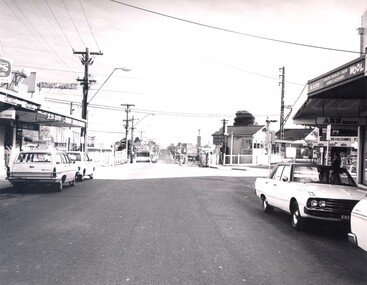
This image is part of a larger collection of images from the Public Transport Corporation displaying train stations and streetscapes in what is now the City of Kingston.Black and white photograph depicting the level crossing at Highett, with the shopping street visible in the foreground. There are several cars parked on both sides of the road and a bus has just crossed the crossing (on the left hand side).Stamped in blue ink on reverse: COPYRIGHT / Public Transport Corporation / For re-ordering photographs / Please quote negative No H3983 / Enquiries C/- PTC Photographic Unit / Telephone switchboard 619 111highett, railway station, suburbs, streetscape -
 City of Kingston
Photograph - Black and white, Public Transport Corporation, c. 1960
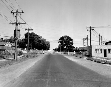
Black and white photograph depicting closed crossing gates at the level crossing at Park Road, Cheltenham. This image is part of a larger collection of images from the Public Transport Corporation displaying train stations and streetscapes in what is now the City of Kingston.Black and white photograph of Cheltenham level crossing at Park Road, Cheltenham. The gates are closed. Stamped in blue ink on reverse: COPYRIGHT / Public Transport Corporation / For re-ordering photographs / Please quote negative No H3052 / Enquiries C/- PTC Photographic Unit / Telephone switchboard 619 111 White paper stuck to reverse of image, with black typed text: Cheltenham Park Road, Cheltenham / 1965 / $50 reproduction fee appliescheltenham, railway crossing, suburbs, public transport -
 City of Kingston
Photograph - Black and white, c. 1930
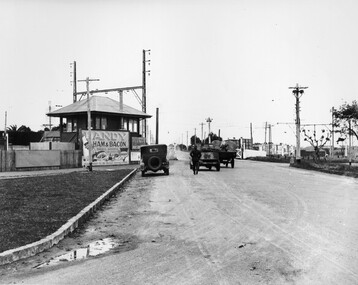
This image is part of a larger collection of images from the Public Transport Corporation displaying train stations and streetscapes in what is now the City of Kingston.The Nepean Highway is a major highway running through the City of Kingston. This image is one of many that depicts its importance to the local community as it undergoes many changes over time.Black and white photograph depicting the level crossing at Moorabbin. While the gates at the level crossing are open, two cars are making their way across the crossing, while a third car is parked on the side of the road, in front of a large billboard/hoarding for ham and bacon products. There is a man standing on the road as if watching the cars go through the crossing. The road appears to be unsealed. Black printed text on a round white sticker adhered to the reverse: 148 Handwritten in red ink: 60% Blue ink stamped on reverse: COPYRIGHT / Public Transport Corporation / For re-ordering photographs / Please quote negative No ADU907 / Enquiries C/- PTC Photographic Unit / Telephone switchboard 619 111moorabbin, trains, railway crossing, level crossing, cars, roads, nepean highway -
 City of Kingston
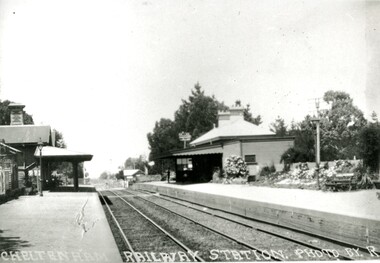
Photograph - Black and white, Percy Fairlam, c. 1920
Cheltenham station was built in 1898 and serviced a primarily rural, market gardening community.The late 1870s saw the beginning of a massive program to construct railway lines throughout Victoria. One of these lines was from Caulfield to Frankston. A survey undertaken by J P Madden, an engineer employed by the railways, established the route, although this was later modified. At the time of the official opening of the line to Mordialloc no station buildings had been constructed despite the fact that tenders had been called in the Government Gazette of 26 May 1881 and subsequently in the Argus newspaper on 30 August 1881 for what became stations at Glenhuntly, Ormond, Bentleigh, Moorabbin, Highett, Cheltenham, Mentone and Mordialloc. However platforms and sidings were completed, ready to receive passengers. Cheltenham station opened in 1898.Black and white photograph of Cheltenham Railway Station with the two platforms separated by two sets of tracks. Each platform has a station house on it, and the one on the right hand side also has a garden and park bench.Handwritten in red ink on reverse: A7 / 75%cheltenham, trains, railway, railway station, railway crossing, suburbs