Showing 91248 items
matching victoria.
-
 Ballarat Heritage Services
Photograph, Mullock Heap In Victoria Park, Ballarat, 2014, 04/11/2014
The large mullock heap, marks the site of a former quartz mine, and is one of the few visible signs of the former presence of extensive gold mining activities in this area of Ballarat. Originally known as Park Mine, and now known as Mount Holled Smith, the mine associated with this mullock heap puddled 750 tons of washdirt each day. The mine closed down in 1874, at which time 94,699 ounces of gold had been removed from the ground. Colour photograph of a mullock heap in Ballarat's Victoria Park.mullock heap, ballarat gardens, victoria park, park mine -
 Ballarat Heritage Services
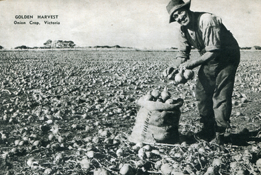
Image - Black and White, Bagging Onions in Victoria, c1950, c1950
A black and white image of a man bagging onions in Victoria. onions, framing, horticulture -
 Ballarat Heritage Services
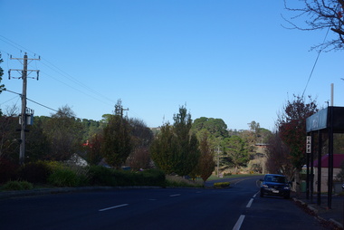
Photograph - Colour, Linton, Victoria, 2013, 22/05/2013
Colour photographs taken in the main street of Linton, Victoria.linton -
 Ballarat Heritage Services
Photograph - Colour, Clare Gervasoni, Linton, Victoria, 2013, 22/05/2013
Colour photographs taken in the main street of Linton, Victoria.linton -
 Southern Sherbrooke Historical Society Inc.
Booklet, "The Hiker's Handbook Of Wonderful Walks In Victoria", May-36
Photocopy of 1936 booklet detailing walking tracks in Victorialockwood, belgrave, selby, narre warren, dandenong reservoir -
 Tarnagulla History Archive
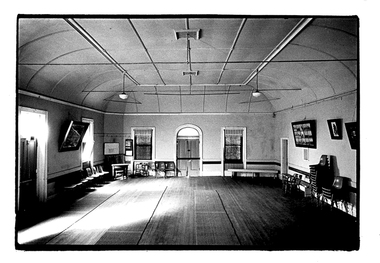
Photograph of the interior of the Victoria Theatre, Tarnagulla, Interior of the Victoria Theatre, Tarnagulla, c. 1960s
Murray Comrie Collection. A monochrome photograph depicting the interior of the Victoria Theatre, Tarnagullatarnagulla, commercial road, victoria theatre, tarnagulla public hall -
 Lakes Entrance Historical Society
Photograph - Butter factory at Bruthen Victoria, 1/03/2000 12:00:00 AM
Acquired by Bruthen Heritage Group buildings requiring complete and expensive restorationColour photograph of the old butter factory at Bruthen Victoriabuildings, agriculture, farming -
 Lakes Entrance Historical Society
Photograph - Buchan Victoria, 1925
Sepia toned photograph of view approaching Buchan Victoriatopography, exploration -
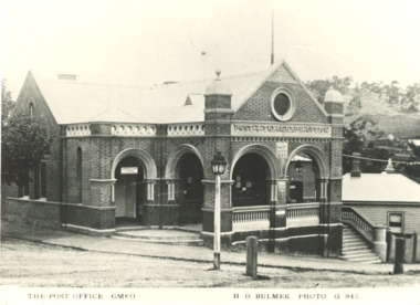 Lakes Entrance Historical Society
Photograph - Post Office, Omeo Victoria, H D Bulmer, 1940 c
Built in 1890 cBlack and white photograph of Post Office at Omeo VictoriaThe Post Office Omeogovernment services, postal services -
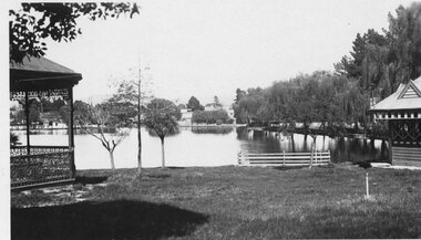 Stawell Historical Society Inc
Photograph - Valentine Series No. 1082 Lake Victoria Park, Stawell, Victoria Park Stawell with two Rotundas one cast iron and one wood (Now Cato Park)
Valentine Series Postcard. Victoria Park later Cato Park at Head of the St George Mine Dam originally established with donations from Mr E Simmons and voluntary efforts. Shows two rotundas.B/W Photo. Valentine Series No. 1082 Lake Victoria Park, Stawell. Taken between the two rotundas showing lake, pier and older willows. Both now renamed Cato lake and Cato park.Valentines Real Photo Series Logo. Published by the Valentine Publishing Co. Pty. Ltd. Queen St. Melb.stawell -
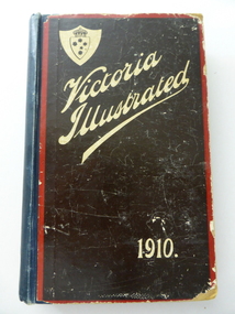 Warrnambool and District Historical Society Inc.
Book, Victoria Illustrated 1910 x 3, 1910
These are three copies of ‘Victoria Illustrated’, a publication issued in 1910 by the Victorian Government containing information and photographs of places in Victoria. There are fifteen pages describing Warrnambool. One copy belonged to Bert and Henri Worland. It is presumed that Bert was the older brother of Henri Worland, the Town Clerk of Warrnambool from 1918 to 1949. Henri Worland was one of Warrnambool’s most important historians and was responsible for collecting much of the historical material that is now in the possession of the Warrnambool and District Historical Society. He also wrote about Warrnambol’s history and was well-known in the 1940s for his 3YB radio broadcasts about Warrnambool’s history. His brother Albert was an insurance agent in Warrnambool. This book is of considerable importance as the material on Warrnambool and district covering the year 1910 is of great interest to historians today and is much used. There is a wealth of information on many Warrnambool businesses at that time. The connection with the Worland family is also of interest. These three copies of ‘Victoria Illustrated’ contain information on Victoria early in the 20th century and contain printed text, many black and white photographs and illustrations and advertisements for Victorian businesses. .1 A hard cover book with a dark blue cover and a pasted brown covering on the front and back cover. The front cover has white lettering and an image of a shield with a crown and the Southern Cross and the back cover has an illustrated advertisement for Buchanan’s Whisky. The inscriptions are handwritten in blue ink. .2 The cover is completely detached and the spine is missing. There are 14 pages missing at the end of the book. .3 The cover is missing with a photocopied front page. The outside pages are tattered and three pages are missing from the back. .1 - ‘W.P.T. to Bert & Henri Worland’ ‘H. Worland’ history of warrnambool, henri and albert worland -
Yarrawonga and Mulwala Pioneer Museum
Map, Map of Victoria, 1868
Original property of Alice Rebecca Puckey [nee Ford] Born England 23/07/1867 Died rosbud Vic 16/03/1951 Grandmother of Merven Elizabeth Clarke 30 Sturt st Mulwala1868 Map of Victoria -
Whitehorse Historical Society Inc.
Pamphlet, Police in Victoria 1836 - 1980, 1980
History of Victoria Police bookHistory of Victoria PoliceHistory of Victoria Police bookvictoria police force, police -
Whitehorse Historical Society Inc.
Book, Pictorial history of Victoria, 1974
A pictorial history of Victoria.A pictorial history of Victoria.A pictorial history of Victoria.schwerkolt cottage, victoria -
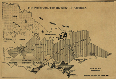 Ballarat Heritage Services
Map, Physiographic Divisions of Victoria, c1940, c1940
Physiographic map of Victoriavictoria, map, physiography -
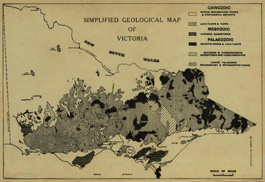 Ballarat Heritage Services
Map, Simplified Geological Map of Victoria, c1940, c1940
Physiographic map of Victoriavictoria, map, geology, geological -
Stawell Historical Society Inc
Map, Geological Survey of Victoria
Geological Survey of Victoriastawell -
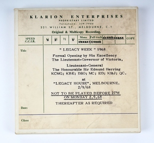 Melbourne Legacy
Audio - Recording, tape, Legacy Week 1968. Formal Opening by his Excellency The Lieutenant-Governor of Victoria, 1968
A tape recording of Sir Edmund Herring, The Governor of Victoria, for the opening of Legacy Week in 1968. It may have been played on radio to promote Legacy. Taped voice recording messages were a common means of communication at this point in time. More compact, lighter and less cumbersone than vinyl records.A record of a launch of Legacy Week by a prominent Australian.A recording on a tape for Legacy Week 1968 in an off white cardboard box.Label, “Legacy Week” 1968, Formal Opening by His Excellency The Governor of Victoria, The Lieutenant-Governor of Victoria, Lieutenant The Honourable Sir Edmund Herring KCMG; KBW; DSO; MC; ED;KStJ; QC. At “Legacy House” Melbourne. 2/9/68 Not to be played before 2PM on Monday 2. 9. 68 Thereafter as required.legacy week, governor of victoria, sir edmund herring, legacy promotion -
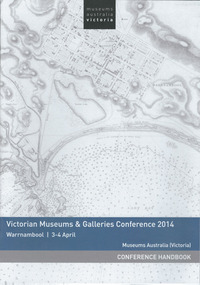 Warrnambool and District Historical Society Inc.
Booklet, Museums Aust Victoria, 2014
This is the handbook for the third annual Victorian Museums & Galleries Conference held in Warrnambool. The conference was run in conjunction with Flagstaff Hill Maritime Village which was celebrating its 40th anniversary. Warrnambool Art Gallery was one of the sponsors of the conference. This handbook is of interest as it tells us of the activities and speakers at a conference which was held in Warrnambool in 2014 and which highlights particularly Flagstaff Hill Maritime Village and the Warrnambool Art Gallery. This is a paper back booklet of 16 pages. It is the Conference Handbook of the Victorian Museums & Galleries Conference 2014 which was held at Warrnambool in April 2014. The pages contain printed material, advertisements, the conference program and information on the conference presenters. The cover has a white background with a map of Warrnambool Bay and town (Stanley 1870) on the front cover and an advertisement on the back cover.Front Cover: Museums Australia, Victoria, Victorian Museums & Galleries Conference 2014, Warrnambool 3-4 April, Museums Australia (Victoria), Conference Handbookvictorian museums & galleries conference. -
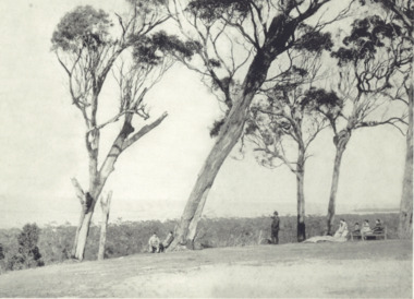
 Ringwood and District Historical Society
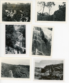
Photograph, 28 photos of Ruby Harker (nee Wilson) and friends and views - Grampians Victoria c 1940s etc; Also Rockhampton Gardens (2 photos)
Ruby Harker (nee Wilson) and friends on holiday in the Grampians and elsewhere, Victoria., and Rockhampton.28 small Black and white photos of scenic spots in the Grampians in Victoria, Coastline, caves and also Rockhampton Gardens. Ruby and friends. Some have written descriptions on the reverse but no dates. (Scanned in groups of 6). See also VC record 28011 which has more holiday photos of the Grampians etc. -
 Flagstaff Hill Maritime Museum and Village
Book, Acts of Parliament of Victoria 33 & 34
Acts of Parliament of Victoria 33 & 34 Victoria 1870 Publisher: Government Printer Melbourne Date: 1871warrnambool, shipwrecked-coast, flagstaff-hill, flagstaff-hill-maritime-museum, maritime-museum, shipwreck-coast, flagstaff-hill-maritime-village, shipwrecked-artefact, great ocean road, book, warrnambool library, warrnambool mechanics’ institute, mechanics’ institute library, victorian library board, warrnambool books and records, warrnambool children’s library, warrnambool public library, acts of parliament of victoria 33 & 34 -
 City of Whittlesea
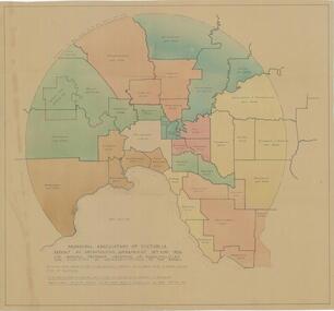
Map - Maps, Municipal Association Of Victoria groupings of councils for representation, 1936
Map was produced as part of Municipal Association of Victoria report on Metropolitan Government, 18 May 1936. Map shows proprosed groupings of municipalities for election of representation to the MAV Board. Map includes net annual value of rateable property within each municipality. The net rateable value for metropolitan area of the Shire of Whittlesea in 1936 was £20,102. Maps, paper. Produced as part of Municipal Association of Victoria report on Metropolitan Government, 18 May 1936. Map shows proprosed groupings of municipalities for election of representation to the MAV Board. council, municipal association of victoria -
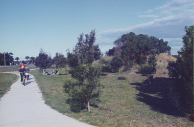 Lakes Entrance Historical Society
Photograph - Esplanade Lakes Entrance Victoria, Lakes Entrance Tidy Town, 1995 c
wo children and an adult riding bicycles on pathway between south end of North Arm bridge and Bullock Island road. Middle distance left turn into Marine Parade foreground now site of skate park. In distance palm trees at entry to Esplanade Lakes Entrance VictoriaColour photograph showing two children and an adult riding bicycles on pathway between south end of North Arm bridge and Bullock Island road. Middle distance left turn into Marine Parade foreground now site of skate park. In distance palm trees at entry to Esplanade Lakes Entrance Victoriarecreation, topography, roads and streets, parks -
 Lakes Entrance Historical Society
Photograph, Lakes Post Newspaper, Lake King, Metung Victoria, 1/02/1999 12:00:00 AM
Colour photograph of road around Lake King Beach looking South, Metung Victoria. Also a colour photograph showing rocky shore of Lake King Beach Metung Victoria boardwalk, people, waterways -
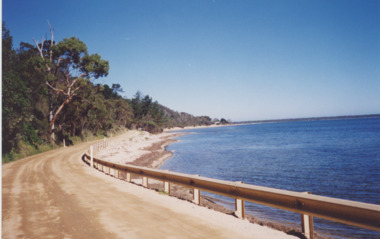
 Lakes Entrance Historical Society
Photograph - Roadknights Merrangbaur property Lakes Entrance Victoria, J Brookes, 1889
Roadknights Merrangbaur property looking towards the natural entrance, seven people sitting or standing on brow of hill Lakes Entrance Victoria. Also a colour photograph taken from Merrangbaur hill of warm holes and dunes and ocean approximate site of original entrance taken in 1995 Black and white photograph taken from Roadknights Merrangbaur property looking towards the natural entrance, seven people sitting or standing on brow of hill Lakes Entrance Victoria. Also a colour photograph taken from Merrangbaur hill of warm holes and dunes and ocean approximate site of original entrance taken in 1995 historic site, topography, ocean -
 Surrey Hills Historical Society Collection
Photograph, Streetscape near the corner of Victoria Crescent and Hotham Street, Surrey Hills
Prior to subdivision for housing this area was paddocks used for grazing of cattle and used as part of the course in the early days of the Surrey Hills Golf Club. Reproduced by permission of Mr John Arnold from his book: "The Riversdale Golf Club - a history, 1892-1977." Copyright to book: Riversdale Golf Club. Surrey Hills Golf Club operated from 1892-1908 then moved and became Riversdale Golf Club. The game was played across paddocks from Trafalgar Street, Mont Albert to Whitehorse Road and down Victoria Crescent to where Box Hill TAFE is now located in Elgar Road. There were problems with cows eating the tee flags! The clubhouse still exists as 30 Trafalgar Street.Black and white photo taken from the centre of a bitumen road which is flanked by bluestone guttering. Nature strips, drive cross-overs and house fences are shown. Trees on the RHS nature strip are pollarded to avoid overhead power and telephone lines. There houses in the background."Bottom: The same view today taken from the intersection of Victoria Crescent and Hotham Street, Surrey Hills."surrey hills golf club, hotham street, victoria crescent, riversdale golf club, surrey hills, john arnold -
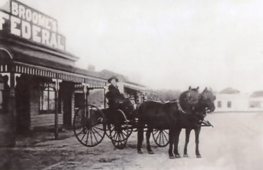 Lakes Entrance Historical Society
Photograph - Brooms Federal Coffee Palace Esplanade Lakes Entrance Victoria c 1910, 1910 c
E Broome seated in a horse drawn vehicle outside Brooms Federal Coffee Palace Esplanade Lakes Entrance Victoria c 1910. Also another view of Broomes Federal Coffee Palace showing crowd at front of building flimsy jetties along foreshore 04327.1, 10 x 15 cmBlack and white photograph of a postcard showing E Broome seated in a horse drawn vehicle outside Brooms Federal Coffee Palace Esplanade Lakes Entrance Victoria c1910. Also another view of Broomes Federal Coffee Palace showing crowd at front of building flimsy jetties along foreshore businesses, shops, social history, transport -
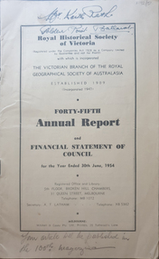 Federation University Historical Collection
Booklet, Royal Historical Society of Victoria 45th Annual Report and Financial Statement of Council, 06/1954
The RHSV was established in 1909.14 page annual report of the Royal historical Society of VictoriaFront cover "Mr Keith Rash Golden Point Ballarat" "Your article will be published in the 100th magazine".royal historical society of victoria, annual report -
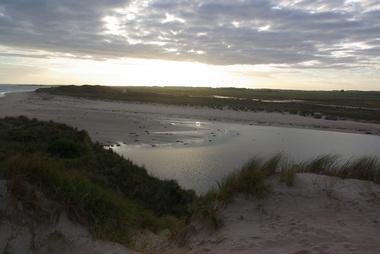 Victorian Interpretive Projects Inc.
Photographs - Colour, Killarney Beach, Victoria, 2014, 13/09/2014
Killarney beach is in close proximity to Port Fairy and Koroit,A number of colour photographs showing scenes of Killarney Beach, Victoria.killarney, beach -
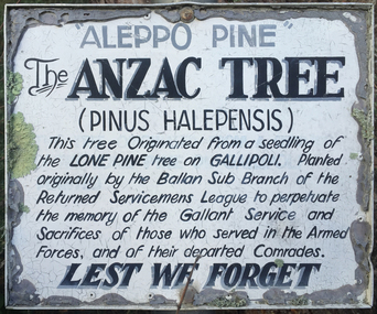 Victorian Interpretive Projects Inc.
Photograph - Colour, Clare Gervasoni, Lone Pine at Ballan, Victoria, 2015
Three photographs relating to a Lone Pine planted at Ballan Victoriaballan, world war, world war one, lone pine, gallipoli, mmm