Showing 870 items
matching water colour
-
 Melbourne Legacy
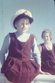
Slide, Operation Float 1958, 1958
Operation Float was an event run by Melbourne Legacy to take Junior legatees on an outing. It could have been to naval boats such as HMAS Cerberus or to a Yacht club. It gave the junior legatees the opportunity to see a naval boat in action, spend time on the water or try sailing. More images from the same outing are catalogued at 02478 and 02480. The slides have been photographed to make digital images and moved to archive quality sleeves. In many cases the original images were not well focussed and the digital image the best available.A record of an event for junior legatees in the 1950s.Colour slide x 8 of operation float in 1958 in red Hanimount slide mounts.operation float, boats, junior legatee outing -
 Melbourne Legacy
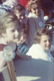
Slide, Operation Float 1958, 1958
Operation Float was an event run by Melbourne Legacy to take Junior legatees on an outing. It could have been to naval boats such as HMAS Cerberus or to a Yacht club. It gave the junior legatees the opportunity to see a naval boat in action, spend time on the water or try sailing. More images from the same outing are catalogued at 02477 and 02478. There is one image with the children meeting a goat that is at the harbour. The slides have been photographed to make digital images and moved to archive quality sleeves. In many cases the original images were not well focussed and the digital image the best available.A record of an event for junior legatees in the 1950s.Colour slide x 5 of operation float in 1958 in red Hanimount slide mounts.operation float, boats, junior legatee outing -
 Mordialloc College Alumni Association Inc (MCAA)
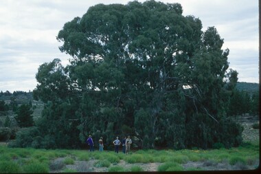
Photograph, 1979 Wyperfeld Old Be-al River Red Gum Tree, 1979
1979 - Mordialloc-Chelsea High School students standing in front of “Old Be-al” in Victoria’s Wyperfeld National Park, near Outlet Creek. It has been described as one of the most magnificent River Red Gums in the land. This glorious tree with foliage hanging to the ground escaped the fire of 1959 but not the fire of 1982 that damaged it badly. It lives on but has also suffered from lack of water and is now inaccessible to the public in a reference area. The MCAA has provided this image to the Friends of Wyperfeld National Park. Mordialloc-Chelsea High School students visited the Wyperfeld National park annually for the biology and geography Year 11 school camp.Example of a River Red Gum at Wyperfeld National Park.Digital image reproduced from colour slide.big desert fire 1959, mordialloc-chelsea high school camp, wyperfeld national park, fire 1982, old be-al river red gum -
 Wodonga & District Historical Society Inc
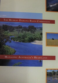
Booklet - Murray-Darling Basin Commission: Managing Australia's Heartland, 1992
This 16 page booklet outlines the role of the Murray-Darling Commission and water management strategies. It includes colour illustrations and maps.non-fictionThis 16 page booklet outlines the role of the Murray-Darling Commission and water management strategies. It includes colour illustrations and maps.murray-darling basin management, natural resources, murray-darling basin commission (australia) -
 Wodonga & District Historical Society Inc
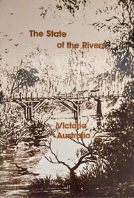
Book - The State of the Rivers, Victoria Australia, Constable, D & Smith, K, 1983
Rivers play an essential part in the life and wealth of our society. They are also the most striking feature of the landscape, contributing much to the beauty of rural and urban surroundings as well as to the recreation, peace and happiness of our people. This report includes historical colour and black and white photos and maps. It aimed to give an accurate account of the condition of the rivers of Victoria. It was produced by the Standing Consultative Committee on River Improvement.A 64 page volume including text, black and white and colour images and maps.Rivers play an essential part in the life and wealth of our society. They are also the most striking feature of the landscape, contributing much to the beauty of rural and urban surroundings as well as to the recreation, peace and happiness of our people. This report includes historical colour and black and white photos and maps. It aimed to give an accurate account of the condition of the rivers of Victoria. It was produced by the Standing Consultative Committee on River Improvement.rivers in victoria, conservation victoria, water supply victoria -
 Woodend RSL
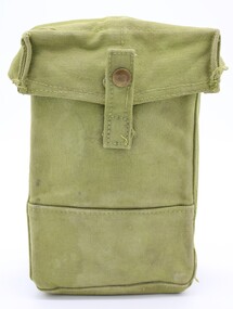
Equipment - Pattern 37 Utility Pouch
Utility Pouch was a rectangular web case that was designed to carry three Bren 30 round magazines, or two Anti-tank Rifle Magazines, or Small Arms Ammunition, or a number of Grenades, or a Water Bottle. They were secured with a flap at the top, hinged at the rear, which was fastened with a brass stud fastener on a short web tab.The object is representative of utility pouch/pouch for carrying magazine/ammunition and other items of equipment from the mid to late 20th century. The original design is the 1937 pattern web equipment.Utility Pouch of rectangular web case. Of rectangular parallelepipped shape made of thick and sturdy fabric (canvas). The colour is of a pale shade of green. Front view - Rectangular shape with overlapping closing flap with a press-stud fastener to maintain closed. Left and right views - Both sides are identical. Made of a one piece of fabric forming the base as well ("U" shape) Back view - Rectangular with metal hooks on the middle part for attachment to a belt. There is a Twigg buckle on the top part of the pouch mounted on another piece of canvass ending in a triangular shape. . Bottom view - ‘the fabric forming the base is also forming the sides of the pouch. Top view - closing flap overlapping on 3 sides and forming part of the back of the pouch. Inside view - There is excess fabric from the back panel that forms an additional layer at the base of the pouch.. Handwritten on the back: 3/750133. DELVE S.J.E. On the inside of the closing flap: presence of very faded markings (unreadable) -
 City of Kingston
Photograph - Colour, 6 March 1993
Edithvale is a suburb in the City of Kingston. It is located between Aspendale and Chelsea on the Port Phillip Bay and built within remnant areas of the Carrum Carrum swamp. The foreshore precinct comprises a wide sandy beach, with low sand dunes and numerous historic boat sheds. The suburb consists of older style dwellings and former holiday houses, combined with mid-century housing and newer homes. The large blocks are increasingly subdivided and the existing dwellings demolished to accommodate units and townhouses, thus changing the landscape of the area and reducing the tree canopy.The beachside suburb of Edithvale was previously part of the extensive Carrum Carrum Swamp. The area was once a source of fish and eels for the Mayone-Bulluk clan of the Bunurong people. Over time the area was drained and predominantly devoted to dairy farming and holiday houses. The farms were gradually sold and subdivided with a large number of homes built after World War II and in the 1960s. Edithvale is mainly residential with a shopping strip along Nepean Highway but little significant industry was ever established in the area apart from a plaster works and confectionary factory, both now closed.Laminated aerial colour photograph of Edithvale as viewed from Alexandra Avenue in the north to Ella Grove Chelsea/Edithvale in the south. regents Park Aspendale can be seen in the top left. The area is built-up with residential housing and facilities including Edithvale Primary School, numerous churches and the Edithvale Railway station. Large sections depict the remnant Carrum Carrum swamp. Edithvale Common and the former "Duck Inn" (Melbourne Water/Friends of Edithvale Seaford Wetlands) can be seen. Edithvale Recreational reserve, the valodrome and Edithvale Public Golf Course are prominent. The image shows vacant land in the area now known as Aspendale Gardens and the newer residential section of Chelsea Heights is not developed. A bike path has been established to cover the secondary drain. The Golf Links Court residential development located off Hughes Avenue is a large vacant block.Black type on white adhesive label: 6-3-93 Black type on white adhesive label: 25/9211, 6/3/93, 11.20 am Black type on white adhesive label: 9211 Yellow circular adhesive sticker Black pencil: 9211 6-3-93 arrow pointing Nedthvale, carrum carrum swamp, aspendale, chelsea -
 Melbourne Legacy
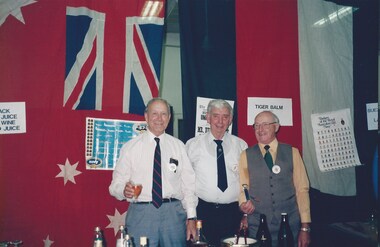
Photograph, Comradeship event - Dugout
Photos of an event at Legacy House for the Legatees approximately 1992 or 1993.There are flags including the Union Jack, Australian flag, the Navy flag and possibly a French flag. There is a display of military hats as well. Likely to be a 'Dugout Night' where Legatees have a comradeship event around the time of Anzac Day in April. As well as flags there are signs such as 'Tiger Balm, Arrack, Jack Juice, Rice Wine, Suez Canal Water'. Identifiable legatees include John Stevenson (President in 1992), Fred Holdsworth (in airforce cap), Don Simonson (President in 1991) and Charles Munnerley who was chairman of the widows committee for many year to 1993. Also a legatee playing piano. A record of the comradeship of the Legatees.Colour photo x 8 of a legatee event with flags and military hats.legatee event, comradeship, dugout -
 Lakes Entrance Historical Society
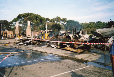
Photograph, 2000
Date made December 2000Colour photograph showing destroyed Club Hotel. Photo taken from the Esplanade, front carparks covered with water and hoses as Lakes Entrance Fire Brigade damp down remaining trouble spots. Lakes Entrance Victoriahotels, fire brigade, disasters -
 Lakes Entrance Historical Society
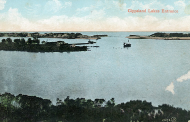
Photograph - The Entrance, 1910c
Colour tinted photograph of the entrance from Bass Strait to the Gippsland Lakes. It shows the small village on the hummocks, Bullock Island with bathing boxes at western end, machinery building groyne's from Bullock Island. Boat in the water. Lakes Entrance VictoriaGippsland Lakes Entranceislands, ships and shipping, topography, waterways -
 Lakes Entrance Historical Society
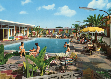
Postcard, Engelander, John & Co Pty Ltd, 1950c
Colour postcard of the outdoor swimming pool at Glenara Motel, Lakes Entrance, Victoria. Shows adults and children on the paved area around the pool and three people in the water.motels, recreation, entertainment, rsl clubs -
 Lakes Entrance Historical Society
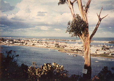
Photograph - Township, 1980
Also two different views of Lakes Entrance from KalimnaColour photograph showing the township situated on the land between the two stretches of water, the North Arm and the Cunninghame Arm. In the background can be seen the sand hummocks and the Southern Ocean. Lakes Entrance Victoria township, waterways -
 Ballarat Heritage Services
Photograph - Digital photograph, L.J. Gervasoni, Fletcher Jones Ball with Cross, c2010-2017
Two colour digital Images showing the Former Fletcher Jones Factory ball with cross. fletcher jones, factory, ball, water tower, cross, warrnambool -
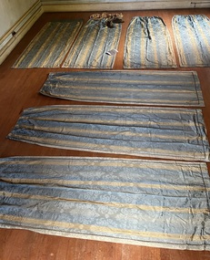 Villa Alba Museum
Decorative object - Suite of seven curtain panels, 1850s-90s
The curtains are significant for their comparative rarity of survival, and at the same time, are highly representative of opulent colonial taste in interior decor in the boom period. The curtain panels are of high quality materials and in unusually good condition, indicating they were used in a window with relatively little sunlight shining on them. They can be imagined in a grand room with one or more matching dressed windows.7 curtain panels, all the same size, possibly to fit a 3-light bay window; or alternately, to fit 3 windows in the same room (or something else altogether, if this is not the original total number of panels). Fabric: silk-wool mix, sky blue ground with narrow vertical gold stripes. The fabric is a damask weave with a watered (moiré) finish; the large, woven motif depicts an urn filled with stylised flowers, leaves and curlicues; the spacing of the motifs is more 19thC than older styles using much the same motif. Each curtain drop is decorated with an applied band of narrow, colour-matched gimp braid around the sides and lower end. The bottom hems are weighted with what feels like lead shot. The curtains are lined with sturdy brown cotton. They are gathered at the top edge on drawstring tape; and hand-sewn with small metal hanging rings. Faded vertical bands of sun exposure are visible on most of the curtains, and one panel has a mended tear on a lower side. Otherwise they are in excellent, sound condition.interior decoration-19th century, curtains-19th century, colonial taste-victoria, gold boom melbourne -
 Charlton Golden Grains Museum Inc
Photograph, Brownjohn, Reg, Rear of Johnson's Bridge Store c. 2000, c.2000
Derelict rear of building built as Bridge Store in 1872 for Peter Johnson, later Wylie's Building and a furniture store. Photo taken for the Museum.Colour photograph of the rear of an old, brick two storey building. Building appears derelict and disused. Not all the building is in the photo. Old rainwater tank on RH side, part of the roof is missing and the beams are exposed. Gas tank/hot water service in corner in the centre of the photo. Single door to the right of the gas tank and double doors to the left.bridge store, peter johnson, wylie's building, business -
 Charlton Golden Grains Museum Inc
Photograph, Brownjohn, Reg, Rear of Johnson's Bridge Store c. 2000, c.2000
Derelict rear of building built as Bridge Store in 1872 for Peter Johnson, later Wylie's Building and a furniture store. Photo taken for the Museum by R. Brownjohn.Colour photograph of the rear of an old, brick two storey building. Building appears derelict and disused. Part of the roof is missing on the lower section and the beams are exposed. Verandah is sagging. Gas tank/hot water service in corner in the centre of the photo. Single door to the right of the gas tank and double doors to the left. One large and one small window in the upstairs section. Chimney on LH side of upper storey.bridge store, peter johnson, wylie's building, charlton, business -
 Lakes Entrance Historical Society
Photograph - Boggy Creek Gorge, 1999
Boggy Creek Gorge cuts through volcanics just before it meets salty water at Nowa Nowa Arm of Lake Tyers.Colour photograph from a vantage point of the distant Boggy Creek Gorge surrounded by steep tree and scrub covered ranges. Nowa Nowa Victoriavegetation, waterways -
 Lakes Entrance Historical Society
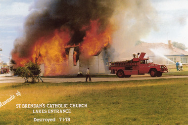
Photograph - St. Brendan's Lakes Entrance, 1978
Date made 7 January 1978Colour photograph of the disastrous fire which destroyed St Brendans RC Church. Two fire trucks in view, three people directing water onto home of Nuns next door to church. Ferris wheel of carnival in distance behind church. Lakes Entrance VictoriaMemento of St Brendan's Catholic Church, Lakes Entrance, destroyed 7.1.78 buildings, disasters, fires -
 Lakes Entrance Historical Society
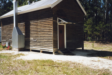
Photograph - Noorinbee State School, 2000
School built by local community as school and public hall in 1900, 26 July, classified by National Trust.Colour photograph of the old Noorinbee State School no. 3372, East Gippsland, shows a view of the timber building with rebuilt corrugated iron chimney, corrugated iron roof, water tank at rear. Noorinbee Victoriaschools, buildings -
 Lakes Entrance Historical Society
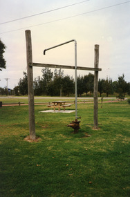
Photograph, 1999
... Society. Water supply Public Utilities Colour photograph ...In late 1958 bore put down in an attempt to obtain good quality water for a reticulated town water supply. Water unsuitable, but during drought years when water supply from Nicholson River was restricted, water from this bore available for public use. Bore plugged, structure removed December 2000. Site marked with plaque March 2001, by Lakes Entrance Historical Society.Colour photograph of the head works including feed pipe of water bore sunk in late 1958 on the Public Reserve bound by Marine Parade and the highway approach to North Arm Bridge, Lakes Entrance, Victoria.water supply, public utilities -
 Bendigo Historical Society Inc.
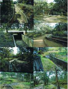
Photograph - COLIBAN MAIN CHANNEL, July,2009
Photograph - colour. All photographs are of the Coliban Main Channel. Photo's 1,2,3,4 + 5 = were taken from South Mandurang Road, Spring Road end. Photo's 6,7,8,9,10,11,12 + 13 = were taken top of dirt road section of Springs Road. Photo's 14 + 15 = Taken between Sedgwick and North Harcourt, used to be called 'Prestonvale'. Photo No.14 is called Wirths Tunnel, 633 metres in length. Three more sheets of photo's of the Coliban Main Channel, between Sedgwick and Harcourt North. If more info.Ray Smith and Phil Wilkin - Bendigo Historical Society.place, water, coliban race, coliban main channel. -
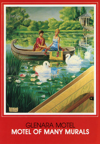 Lakes Entrance Historical Society
Postcard, Scan Colour Australia, 1950 c
Colour postcard of one of the eighteen murals decorating the internal walls of the Glenara Motel, Lakes Entrance, Victoria. This one reflects the painter's romanticism showing a young couple in a small boat on a lake with water lilies and swans.Glenara Motel Motel of Many Murals (on front)motels, arts, rsl clubs -
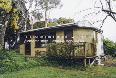 Eltham District Historical Society Inc
Photograph - Colour Print, Alan Marshall's bungalow, 13 Park West Road, Eltham, 22 July 1993
From 1955 Alan Marshall's home was a bungalow at the rear of his sister's house at Eltham. The first bungalow burnt down. Its replacement shown here still stands. In March 2020 the property was sold. It was last sold previously in November 1982. No mention was made in the advertising regarding the heritage protected bungalow in the rear yard and advertising material presented it as having future potential to develop STCA (Subject To Council Approval). Concerned local members of the community alerted to EDHS to the pending upcoming sale and Council was also alerted to the sale and the potential risk presented to the heritage protected bungalow. In 2021 an updated amendment, C133nill, was made to the Nillumbik Planning Scheme in response to a planning application to develop the property following its sale. The Minster of Planning approved and gazetted the Amendment. Gazettal occurred on 25th November 2021. A copy of the gazetted Amendment is available on website of the Department of Environment, Land, Water and Planning at www.planning.vic.gov.au/schemes-and-amendments/browse-amendments. It was last updated March 2022.Colour photo print 10 x 15 cm, originally stuck down on corflute for displayeltham, alan marshall, alan marshall bungalow, heritage assessment, heritage protection overlay, houses, nillumbik shire council, park west road, heritage overlay ho147 -
 Warrnambool and District Historical Society Inc.
Booklet - Warrnambool Visitor's Handbooks 1979-2024, Collett, Bain and Gaspar, Printers, 1979-2014
This is a collection of eight Warrnambool Visitor handbooks produced between 1979 and 2014 by the City of Warrnambool Tourist Information Centre. They contain maps of Warrnambool, lists of services, accommodation and tourist attractions as well as many advertisements for local businesses.These handbooks give a useful snapshot of businesses and tourist attractions in Warrnambool for each of the years covered. (1979, 1980, 1986, 1990, 1993, 1994, 1995, 2014)[.1a] A 48 page booklet with white pages and blue printing. The front cover has a coloured photograph of Flagstaff Hill with boats on a man made lake in the foreground looking across Lake Pertobe toward South Warrnambool. [.1b] A coloured bifold brochure. The front cover has a fisherman on a cray-boat holding a crayfish in the lower section. The top quarter has a blue back ground with white printing. The rear cover is red and has small photos of the Hopkins River and the Framlingham Forest. [.2] A 48 page booklet with white pages and black printing. The front cover is white with black writing on the left hand side and a colour photograph of the Loch Ard peacock. The Warrnambool Premier Town stylised logo of seven Norfollk pines above blue waves is in the top right hand corner. There is a blank ink Warrnambool Library stamp underneath the logo. The rear cover has photographs of The Twelve Apostles and the Hopkins Falls and the Premier Town Logo [.3] A 40 page booklet with mainly black printing on white paper. There are three fold out maps of Warrnambool and the surrounding district. The glossy cover has a black background with a colour photograph of the Twelve Apostles taken at sunset. The rear cover has three small of Proudfoot's boathouse on the Hopkins River, Flagstaff Hill, and the main beach area. The front cover has black writing inside to peach coloured rectangles. The inside rear cover has a fold out coloured tour map of Western Victoria. [.4] A 40 page booklet printed on glossy white paper with coloured photographs and black and red printing. The front cover has a photograph of The Twelve Apostles surrounded by a white border. There is red writing in the upper border. There is a sandy coloured writing superimposed across the bottom of the photograph and a Victoria's Shipwreck Coast logo in the bottom right hand corner. [.5] A 44 page booklet printed on white paper with black printing. The cream coloured cover has a pale red rectangle with blue writing on the right hand facing edge and includes two stylised Norfolk pines and with waves underneath. There is is an intersecting blue rectangle with cream printing. [.6] A 48 page booklet printed on white paper with black printing. The cover is brown with a cream vertical strip containing black writing on the right hand side. There is a stylised map from Geelong to Mount Gambier showing the Great Ocean Road across the cover. [.7] A 48 page booklet printed on white paper with black print. The glossy colour cover has a photograph of a Southern Right whale fluke. There is white printing on a the blue background of the sky and sea. The bottom left hand side of the front cover has a Tourism Victoria logo made of jigsaw puzzle pieces. The back cover has a stylised coloured map of The Great Ocean Road located in a white rectangle at the top of the page. Within the rectangle is a small map of Australia locating Victoria and the part of Victoria covered by the map. [.8] A 64 page A5 coloured booklet printed on white pages with black print. The white front cover has black and grey print with a colour photograph of two people holding coffee cups watching four race horses being exercised on the beach and in the water of Lady Bay in the early morning. The bottom right hand corner has a Tourism Victoria logo. The rear cover has a mainly blue back ground with a pink orange and green colour splats contains words advertising the 2015 Fun 4 Kids Festival [.1a] Warrnambool The Heart of Victoria's Great Southwest Visitor's Handbook [.1b] Warrnambool City for all seasons; The Heart of Victoria's Great Southwest [.2] Warrnambool visitor's handbook Warrnambool Premier Town 1979-1982 [.3] Warrnambool Handbook Victoria [.4] Warrnambool The Shipwreck Coast [.5] Welcome to Warrnambool Warrnambool Visitors Handbook 1993-1994 [.6] Welcome to Warrnambool Visitors Handbook 1994-95 Rear cover: Warrnambool Centre of Victoria's Shipwreck Coast on Australia's Great Ocean Road [.7] Warrnambool Shipwreck Coast - Great Ocean Road; You'll love every piece of Victoria; Visitors Handbook [.8] Warrnambool Great Ocean Road Official Visitor Guide; It's a wonderful Warrnambool; You'll love every piece of Victoria visitvictoria.com. Rear Cover Live entertainment.Workshops.Creativity.Action 28 June - 5 July 2015 Australia's Best Children's Festival F4K The ultimate winter school holiday adventure Fun 4 kids festival Warrnambool For more information visit Fun4kids.com.au Warrnambool great Ocean Road Victoriawarrnambool, visitor handbooks, tourist information guides, warrnambool maps -
Stawell Historical Society Inc
Photograph, Aerial Photos of Stawell from a Hot Air Balloon 1992 -- 12 Photos
Series of 12 Aerial Photos of Stawell. Hot Air Balloon, October 1992 1. Cnr. Maude St & Grant Street 2. Maude St Napier Street & Railway cutting 3. Trotting Track 4. Roundabout Wimmera & Sloane Street 5. Florence Street towards Cato Lake & Park 6. Grampians Range with Lake Lonsdale near center 7. Gold Reef Mall looking West 8. Church Street looking West 9. Looking towards Black Range 10. Moonie Dams Darlington Road Leisure Complex 11. Stawell Gold Mine Evaporations Dams, Stawell Water Reservoirs, Moonie Dams 12. Darlington Road looking towards Black RangeSeries of 12 colour photographs from the Air.stawell -
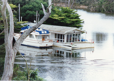 Lakes Entrance Historical Society
Photograph - Box's Creek, Tambo Shire, 1994
Also second identical copyColour photograph of a holiday house, built over the water at Box's Creek, a motor cruiser moored beside the house. Metung Victoriawaterways, tourism, boats and boating -
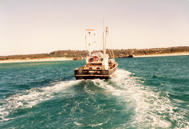 Lakes Entrance Historical Society
Photograph - Southern Hope, Hammarstrom Ian, 1987 c
Colour photograph of the fishing boat Southern Hope approaching the entrance channel, from the ocean, shows sandy beach each side of entrance piers and shallow water over the outer bar, sea calm. Lakes Entrance Victoriaships and shipping, waterways, fishing industry -
 Lakes Entrance Historical Society
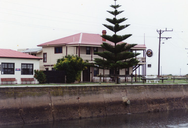
Photograph - Port Albert Hotel, 1985 c
Colour photo of the hotel at Port Albert, showing a neat weatherboard building with verandah and balcony on upper storey, close to water edge. Port Albert Victoriahotels, township -
 Lakes Entrance Historical Society
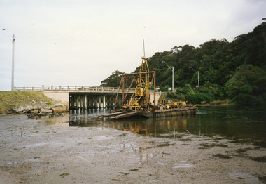
Photograph - North Arm Bridge, 2000
Date made 2 October 2000Colour photograph of the pontoon testing for foundations for proposed new bridge over North Arm water, old bridge Kalimna side. Lakes Entrance Victoriabridges, machinery, construction -
 Lakes Entrance Historical Society
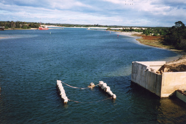
Photograph, 2000
Date made May 2000.Colour photograph of diving operations to attach crane cable to underwater section of piers of old North Arm bridge. Diver in water, small tinny standing by with two men aboard. Lakes Entrance Victoria.bridges, waterways, public works