Showing 1886 items matching "10 years"
-
 Emerald Museum & Nobelius Heritage Park
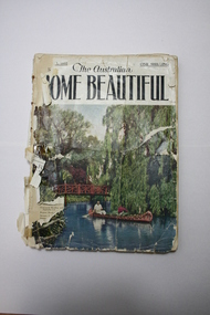
Magazine, The Australian Home Beautiful, June 1932
The Australian Home Beautiful was a popular Magazine years ago .In the May edition there is a local article on a building of importance in Sycamore Ave. EmeraldCollection of Monthly Journals . Vol,10, No.1 January 1. 1932 to June 1932 priced at One Shilling. photo of bridge with canoe under it.January 1st 1932 with advertising and Storieshome beautiful. historical stories. photographs -
 Eltham District Historical Society Inc
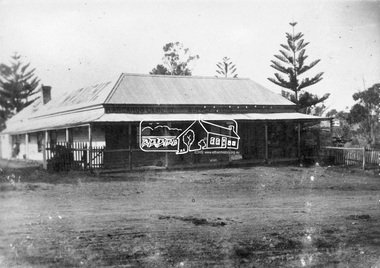
Photograph, C. Wraight's Kangaroo Ground Supply Store, c.1910
Cornelius (Con) and his wife Elizabeth ran the store and post office from about 1904. Their son Donald became involved with the store in the 1930s. A petrol bowser was added in early 1933 and a second in 1937. The Wraights ran the store till the 1940s. Elizabeth died 10 April 1952 and Cornelisu May 30, 1954.This photo forms part of a collection of photographs gathered by the Shire of Eltham for their centenary project book,"Pioneers and Painters: 100 years of the Shire of Eltham" by Alan Marshall (1971). The collection of over 500 images is held in partnership between Eltham District Historical Society and Yarra Plenty Regional Library (Eltham Library) and is now formally known as the 'The Shire of Eltham Pioneers Photograph Collection.' It is significant in being the first community sourced collection representing the places and people of the Shire's first one hundred years.Digital image (negative of original print missing)shire of eltham pioneers photograph collection, kangaroo ground, cornelius wraight, eltham-yarra glen road, general store, kangaroo ground store -
 Eltham District Historical Society Inc
Photograph, View at Eltham, Vic, c.1924
Copy of possible Rose Stereograph Co. postcard “View at Eltham, Vic.”, c.1924 looking southwest from Main Road near York Street to Bridge Street and the original 1875 bridge across what is now the Alistair Knox Park The land in the foreground was first bought from the Crown by J.M. Holloway in 1851. The land was sub-divided and called "Little Eltham". Bridge Street was created as part of the sub-division. Most of the sub-division was residential lots but the creek valley was divided into lots for small farms. Council started to buy the land for the Eltham Town park in the early 1960s. The area was used as a garbage tip and filled above the flood plain of the creek. Development of the land for a park began in the early 1970s. The house on the right was owned for many years by the Hill family until Council bought it in the early 1960s. The house was built in the 1850s or 60s. The house on the left stood on what is now the southwest corner of Susan and Bridge Streets. The Braithwaite family was associated with this house. The double line of fencing in the foreground was a continuation of York Street to the creek. The Bridge Street bridge was built in 1875 and replaced in 1958. (Ref: Early view of Little Eltham; Byways of History by Colleen Ison, Publication unk, 24 August 1982) Reproduced on p61 of 'Pioneers & Painters' Date estimated on same as View at Hurstbridge featuring Wattle Valley EstateThis photo forms part of a collection of photographs gathered by the Shire of Eltham for their centenary project book,"Pioneers and Painters: 100 years of the Shire of Eltham" by Alan Marshall (1971). The collection of over 500 images is held in partnership between Eltham District Historical Society and Yarra Plenty Regional Library (Eltham Library) and is now formally known as the 'The Shire of Eltham Pioneers Photograph Collection.' It is significant in being the first community sourced collection representing the places and people of the Shire's first one hundred years.Digital image 120 format B&W negative Prints 17 x 25 cm and 10 x 15 cmsepp, shire of eltham pioneers photograph collection, eltham, bridge street, bridge, alistair knox park, braithwaite, bridge street bridge, eltham town park, hill family home, main road, pioneers and painters, york street -
 Eltham District Historical Society Inc
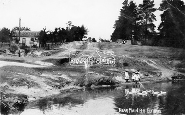
Negative - Photograph, Village Pond, near Main Road, Eltham, c.1908
Village Pond, near Main Road, Eltham, c.1908 Reproduced on p57 of 'Pioneers & Painters'. Looking up Dalton Street from across Maria Street (Main Road), near Whitecloud (Jarrold’s cottage) and the Bootmaker’s cottage, to the left (out of view) of the photographer. The residence of the Head Teacher, Eltham State School No. 209, can be seen on the right, the Grant house on the left (site of present day Eltham Clinic). The willow trees south of Jarrold’s Cottage today mark the site of the old pond, which the Eltham Shire Council evidently filled in to stop mosquitos breeding. The pond and its locality was described in an article about Eltham published in The Australasian, May 2, 1903 - “There is the village pond (so essentially English), reflecting in its clear water a quaint cottage, dwarfed by a huge gum tree, an old smithy, and a hostelry, built quite fifty years ago, the flooring-boards of which the landlord informed me with pride were of Singapore cedar, and quite fit for another fifty years' wear. Then there are the village school, the shoemaker's, the drapery store, and the butcher's shop, all seemingly as they were when first they were erected many years ago.”This photo forms part of a collection of photographs gathered by the Shire of Eltham for their centenary project book,"Pioneers and Painters: 100 years of the Shire of Eltham" by Alan Marshall (1971). The collection of over 500 images is held in partnership between Eltham District Historical Society and Yarra Plenty Regional Library (Eltham Library) and is now formally known as the 'The Shire of Eltham Pioneers Photograph Collection.' It is significant in being the first community sourced collection representing the places and people of the Shire's first one hundred years.Digital image 4 x 5 inch B&W Neg Print 16.5 x 25 cm (2) and 9 x 12.5 cm Postcard 9 x 14 cmOn one print "57 and 11 3/8' x 10' deep"shire of eltham pioneers photograph collection, dalton street, duck pond, eltham, grant house, main road, maria street, village pond -
 Eltham District Historical Society Inc
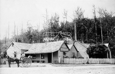
Photograph, M.Jefferson, Watts Bridge Hotel, Fernshaw, Vic
Fernshaw was a rural township 63 km north-east of Melbourne and 10 km north-east of Healesville. Situated on the Watts River, near where a log had fallen making a convenient crossing, Fernshaw was settled in the 1860s. (Source Victorian Places)This photo forms part of a collection of photographs gathered by the Shire of Eltham for their centenary project book,"Pioneers and Painters: 100 years of the Shire of Eltham" by Alan Marshall (1971). The collection of over 500 images is held in partnership between Eltham District Historical Society and Yarra Plenty Regional Library (Eltham Library) and is now formally known as The Shire of Eltham Pioneers Photograph Collection'. It is significant in being the first community sourced collection representing the places and people of the Shire's first one hundred years.Digital imagesepp, shire of eltham pioneers photograph collection, other areas, fernshaw, m.jefferson, watts bridge hotel -
 Eltham District Historical Society Inc
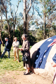
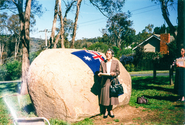
Photograph, Mary Owen, granddaughter of Walter Withers, unveiling the commemorative plaque on Walter Withers Rock at the corner of Bible and Arthur Streets, Eltham, 13 Oct 1990, 13/10/1990
[from EDHS Newsletter No. 75, November 1990:] WALTER WITHERS PLAQUE At long last we have unveiled our plaque in the Walter Withers Reserve. The function was attended by a number of members and friends of the Society and descendants of the Withers family. Following the unveiling, the group proceeded to the Eltham Shire Office for afternoon tea and a small exhibition of Withers' paintings arranged by Andrew Mackenzie. The unveiling was performed by Mary Owen, a grand-daughter of Walter Withers. Her speech provided an interesting personal perspective on Withers and is repeated in full here: I feel somewhat overwhelmed by the responsibility of paying tribute to the man you have all come to honour today. I have the feeling that most of you probably know more about him and his work than I do. Walter Withers died nearly seven years before I was born and so I never knew him. Sadly, although other members of his family inherited some of his talent, I was not among them and I know very little about art. This is doubly hard to bear because my husband had some ability to draw and my second daughter also has some talent in this direction. My children are all artistic - mostly in the field of music inherited partly from their father - a Welshman who sang like a Welshman - and partly from my grandmother, Fanny Withers who, I believe was no mean pianist. However all this talent gave me a miss and for many years I felt a complete ignoramus in the fields of the arts. It was not until I was nearly fifty years old that I walked into a gallery in Brisbane and, as I wandered around the room, suddenly one picture leapt at me and I knew instantly that it had been painted by my grandfather. I had never seen the picture before and it gave me quite a shock to find that I had recognized the style of painting. I realized then that I had absorbed more than I realized simply by living with pictures and with people who painted them and talked about their painting and the painting of others. When I was a child I sometimes spent school holidays with my Aunt Margery Withers and her husband, Richard McCann. Aunt Marge painted me several times but I'm afraid I was a restless subject and used to sit reading a book and look up grudgingly when she wanted to paint my eyes. During the September holidays my aunt and uncle were busy preparing paintings far the annual exhibition of the Melbourne Twenty Painters, to which they both belonged. I remember how important I used to feel when they took me along to the Athenaeum Gallery on the Friday night before the opening to help hang their pictures. There were many artists there but the two I remember are perhaps surprisingly both women: Miss Bale and Miss Tweddle. I remember how cold it used to be up in that gallery at night. They used to heat water on a gas ring to make tea and Aunt Marge used to bring sandwiches and fruit for our evening meal. Everyone seemed to be poor in those days and no-one dreamed of going out for a meal. It was a case of make-do - even to cutting down frames to fit pictures or cutting pictures to fit the frames. They had to use the same frames from year to year if the pictures didn't sell. The opening was an exciting event for me. I felt I was privileged to meet important people - people who knew a lot more than I - and Uncle Dick would get quite merry after a couple of the tiny sweet sherries which were always distributed. I realise now that quite a lot of "art talk" rubbed off on me during my visits to the Athenaeum and during my stays with my aunt and uncle. I suspect that much of our most useful learning comes this way and those of us who have had the privilege of associating with artists, writers, philosophers and other thinkers have a richness in our lives of which we may be unaware. Walter Withers was a prolific painter and, although he painted for love of it, I suspect that the need to provide for his family drove him, like Mozart, to greater efforts than he might otherwise have achieved. Reading old letters and articles about the Heidelberg artists, I have come to realize something of the constant strain placed on many of them - particularly Withers and McCubbin - by poverty and the need to make ends meet. Withers was ever conscious of the need to provide for his wife and his five children and there are touching letters to his wife, regretting that he was not able to earn more for them. In addition to his painting, he worked hard at teaching and illustrating and, as he grew older, the strain began to tell and his health deteriorated. He seems never to have had a very strong constitution and suffered from rheumatism, which must have made painting quite painful at times. His eldest daughter, Gladys, was eventually confined to a wheelchair with rheumatoid arthritis and I have a tendency to arthritis myself, so I am particularly aware of what this could have meant to him. Recently I found a short letter written by my mother to her mother, Fanny Withers on the anniversary of her father's birthday in 1919, in which she said: "Poor old Dad, I often think now what a lot he must have suffered. His life was too hard and too strenuous for him. He had too many chick-a-biddies, I think. He wasn't equal to so much town life and train journeys with so many delicacies as he had. Since I have been ill, I have realised what he must have felt like.” He certainly drove himself to produce. He travelled all over Victoria by train, buggy, bicycle and on foot and for a time he travelled from Eltham to Melbourne every day by train, although later he lived in Melbourne during the week and only returned to Eltham for the weekends. My mother died seven years after her father's death, when my twin sisters were 10 days old and I was 16 months. So I never knew my mother or my grandfather. But my two aunts, Gladys and Margery, sometimes took me to stay with Gan Withers at Southernwood in Bolton Street . No cars in those days and it seemed a very long hot and dusty walk from the Station. Three memories remain with me of Southernwood. One is the well at the back which I found quite terrifying; the second is Gan killing a snake - even more terrifying. She was a formidable woman, my grandmother and a great ally and support to her husband. I think she was the business end of the partnership. The third memory of Southernwood is my grandfather's studio – down what seemed like a toy staircase inside the room. This and the big walk-in fireplace stayed in my mind from the age of about six until I saw them again about forty years later when the house was being used as a Sunday School. I just wish that money could be found to purchase this old house for the City of Eltham so that a permanent museum could be established in memory of a man who did so much to put Eltham on the map of art history. Recently I have become interested in family history and spent some time in England, Ireland and Wales looking for traces of my ancestors. I realized then how important it is to have records of people who have contributed to our society. We forget so soon and it is amazing how often, within two generations, names, dates and many details are forgotten. We are fortunate that so many of Walter Withers' works have been bought by galleries and that people like Andrew Mackenzie have taken the trouble to search out people who knew him and to write about him and his work. And I am very grateful to the Historical Society of Eltham for recognizing the importance of having a permanent tribute in Eltham to the contribution made by Walter Withers, who loved Eltham so much and who has assured this lovely district a place in the annals of history. I am indebted to Kathleen Mangan; the daughter of another famous Australian painter , Fred McCubbin, - featured in The Age this morning (thanks again to Andrew Mackenzie) for the most apt tribute to Walter Withers. Kathleen is not well and she rang me a couple of days ago, regretting that she could not be present today “to pay tribute” as she said, “to Walter Withers for I always think Walter Withers is the spirit of Eltham.” Thank you, Kathleen. And now I have much pleasure in unveiling the plaque commissioned by the Eltham Historical Society from Bob McLellan of Charmac Industries to commemorate the life and work of Walter Withers, the spirit of Eltham. Mary Owen, 13 October 1990.Three colour photographswalter withers rock, walter withers reserve, mary owen -
 Eltham District Historical Society Inc
Photograph, Mary Owen, granddaughter of Walter Withers, unveiling the commemorative plaque on Walter Withers Rock at the corner of Bible and Arthur Streets, Eltham, 13 Oct 1990, 13/10/1990
[from EDHS Newsletter No. 75, November 1990:] WALTER WITHERS PLAQUE At long last we have unveiled our plaque in the Walter Withers Reserve. The function was attended by a number of members and friends of the Society and descendants of the Withers family. Following the unveiling, the group proceeded to the Eltham Shire Office for afternoon tea and a small exhibition of Withers' paintings arranged by Andrew Mackenzie. The unveiling was performed by Mary Owen, a grand-daughter of Walter Withers. Her speech provided an interesting personal perspective on Withers and is repeated in full here: I feel somewhat overwhelmed by the responsibility of paying tribute to the man you have all come to honour today. I have the feeling that most of you probably know more about him and his work than I do. Walter Withers died nearly seven years before I was born and so I never knew him. Sadly, although other members of his family inherited some of his talent, I was not among them and I know very little about art. This is doubly hard to bear because my husband had some ability to draw and my second daughter also has some talent in this direction. My children are all artistic - mostly in the field of music inherited partly from their father - a Welshman who sang like a Welshman - and partly from my grandmother, Fanny Withers who, I believe was no mean pianist. However all this talent gave me a miss and for many years I felt a complete ignoramus in the fields of the arts. It was not until I was nearly fifty years old that I walked into a gallery in Brisbane and, as I wandered around the room, suddenly one picture leapt at me and I knew instantly that it had been painted by my grandfather. I had never seen the picture before and it gave me quite a shock to find that I had recognized the style of painting. I realized then that I had absorbed more than I realized simply by living with pictures and with people who painted them and talked about their painting and the painting of others. When I was a child I sometimes spent school holidays with my Aunt Margery Withers and her husband, Richard McCann. Aunt Marge painted me several times but I'm afraid I was a restless subject and used to sit reading a book and look up grudgingly when she wanted to paint my eyes. During the September holidays my aunt and uncle were busy preparing paintings far the annual exhibition of the Melbourne Twenty Painters, to which they both belonged. I remember how important I used to feel when they took me along to the Athenaeum Gallery on the Friday night before the opening to help hang their pictures. There were many artists there but the two I remember are perhaps surprisingly both women: Miss Bale and Miss Tweddle. I remember how cold it used to be up in that gallery at night. They used to heat water on a gas ring to make tea and Aunt Marge used to bring sandwiches and fruit for our evening meal. Everyone seemed to be poor in those days and no-one dreamed of going out for a meal. It was a case of make-do - even to cutting down frames to fit pictures or cutting pictures to fit the frames. They had to use the same frames from year to year if the pictures didn't sell. The opening was an exciting event for me. I felt I was privileged to meet important people - people who knew a lot more than I - and Uncle Dick would get quite merry after a couple of the tiny sweet sherries which were always distributed. I realise now that quite a lot of "art talk" rubbed off on me during my visits to the Athenaeum and during my stays with my aunt and uncle. I suspect that much of our most useful learning comes this way and those of us who have had the privilege of associating with artists, writers, philosophers and other thinkers have a richness in our lives of which we may be unaware. Walter Withers was a prolific painter and, although he painted for love of it, I suspect that the need to provide for his family drove him, like Mozart, to greater efforts than he might otherwise have achieved. Reading old letters and articles about the Heidelberg artists, I have come to realize something of the constant strain placed on many of them - particularly Withers and McCubbin - by poverty and the need to make ends meet. Withers was ever conscious of the need to provide for his wife and his five children and there are touching letters to his wife, regretting that he was not able to earn more for them. In addition to his painting, he worked hard at teaching and illustrating and, as he grew older, the strain began to tell and his health deteriorated. He seems never to have had a very strong constitution and suffered from rheumatism, which must have made painting quite painful at times. His eldest daughter, Gladys, was eventually confined to a wheelchair with rheumatoid arthritis and I have a tendency to arthritis myself, so I am particularly aware of what this could have meant to him. Recently I found a short letter written by my mother to her mother, Fanny Withers on the anniversary of her father's birthday in 1919, in which she said: "Poor old Dad, I often think now what a lot he must have suffered. His life was too hard and too strenuous for him. He had too many chick-a-biddies, I think. He wasn't equal to so much town life and train journeys with so many delicacies as he had. Since I have been ill, I have realised what he must have felt like.” He certainly drove himself to produce. He travelled all over Victoria by train, buggy, bicycle and on foot and for a time he travelled from Eltham to Melbourne every day by train, although later he lived in Melbourne during the week and only returned to Eltham for the weekends. My mother died seven years after her father's death, when my twin sisters were 10 days old and I was 16 months. So I never knew my mother or my grandfather. But my two aunts, Gladys and Margery, sometimes took me to stay with Gan Withers at Southernwood in Bolton Street . No cars in those days and it seemed a very long hot and dusty walk from the Station. Three memories remain with me of Southernwood. One is the well at the back which I found quite terrifying; the second is Gan killing a snake - even more terrifying. She was a formidable woman, my grandmother and a great ally and support to her husband. I think she was the business end of the partnership. The third memory of Southernwood is my grandfather's studio – down what seemed like a toy staircase inside the room. This and the big walk-in fireplace stayed in my mind from the age of about six until I saw them again about forty years later when the house was being used as a Sunday School. I just wish that money could be found to purchase this old house for the City of Eltham so that a permanent museum could be established in memory of a man who did so much to put Eltham on the map of art history. Recently I have become interested in family history and spent some time in England, Ireland and Wales looking for traces of my ancestors. I realized then how important it is to have records of people who have contributed to our society. We forget so soon and it is amazing how often, within two generations, names, dates and many details are forgotten. We are fortunate that so many of Walter Withers' works have been bought by galleries and that people like Andrew Mackenzie have taken the trouble to search out people who knew him and to write about him and his work. And I am very grateful to the Historical Society of Eltham for recognizing the importance of having a permanent tribute in Eltham to the contribution made by Walter Withers, who loved Eltham so much and who has assured this lovely district a place in the annals of history. I am indebted to Kathleen Mangan; the daughter of another famous Australian painter , Fred McCubbin, - featured in The Age this morning (thanks again to Andrew Mackenzie) for the most apt tribute to Walter Withers. Kathleen is not well and she rang me a couple of days ago, regretting that she could not be present today “to pay tribute” as she said, “to Walter Withers for I always think Walter Withers is the spirit of Eltham.” Thank you, Kathleen. And now I have much pleasure in unveiling the plaque commissioned by the Eltham Historical Society from Bob McLellan of Charmac Industries to commemorate the life and work of Walter Withers, the spirit of Eltham. Mary Owen, 13 October 1990.Two colour photographswalter withers rock, walter withers reserve, mary owen -
 Eltham District Historical Society Inc
Photograph, Henley Bridge, Spring Excursion, Exploring the Upper Yarra, 22 October 1995, 22/10/1995
[article by Bettina Woodburn in EDHS Newsletter No. 105, November 1995:] EXPLORING THE UPPER YARRA - We enjoyed the Spring Excursion, this year "Exploring the Upper Yarra" - in spite of the constant rain and the countryside under the cloud cover, especially in the valleys, being mainly shiny shades of green. The occasional fields of buttercups, clumps of arum lilies and splendid rhododendron and other flowering bushes became very special. The Cobb and Co coach was warm and a cosy retreat as we zig-zagged on the highways and byways to glimpse the Yarra River, upstream and down, its secret places, and particularly the many bridges. Russell excelled as 'Poet Laureate', reading from Dacre Smyth's book. This 1979 publication includes paintings of all the bridges along the river with poems and brief descriptions of each one. Some of the bridges are in out-of-the-way places and are not very well known. We looked forward to hearing the poetry as much as seeing the 'constructions'… Big Pat (was he short or tall, lean or fat? - he did win the £200 reward for discovering gold and had the creek named after him), about the 'Eddies'?, and the disliked 'meccano' bridge in Warburton, etc. etc. The hot roast lunch in the old Reefton Hotel was also most welcome. It was easy to imagine it peopled by miners and early settlers. Starting by crossing the new (1974) concrete bridge at Warrandyte we headed through Wonga Park with views to the Christmas Hills and to the escarpment of the Yering Gorge, which causes flood waters to back up through the Yarra Glen plain, so avoiding disasters downstream. At the end of a long driveway we found the wooden, privately owned Henley Bridge (1935 after the 1934 floods). This facilitates access to different parts of Henley Farm and to Lilydale. Everard Park, named after Blanche Shallard's father, a State Member for 17 years, below the Highway Yarra crossing was in need of care. It is 10 miles from Yarra Glen by road but, as "Yarra Marra” canoeists well know, 32 winding miles down by water. After more delightful countryside scenes we joined the Warburton Highway at Woori Yallock. From the old Railway Station at Launching Place the Centennial Trail for walkers, cyclists and horse riders has replaced the rails. The line from Lilydale was opened in 1901, and the last diesel freight train ran to Warburton in 1965. It continued to rain as we had morning tea in Warburton in a shelter between footbridges. From here we continued upstream past the Bridge to O'Shannassy Lodge and Reservoir, Starvation Creek, and the Peninsular tunnel (miners dug it as at Pound Bend) which we visited (scrambling down those steps!) on our return after lunch. Our furthermost point was the Upper Yarra Dam Reserve (and vast catchment area). Finished in 1957 after ten years' work and 100 years after Yan Yean, it supplies much of Melbourne's water. After crossing the 30m Launching Place Bridge to the Eltham side of the Yarra and Healesville, we saw in the distance the Yarra Glen Timber Trestle Bridge over the river flats "the longest for years in the land it was said!" Harry's dream of "better weather over the Divide" unfortunately didn't come true, but I'm sure we 36 members will retain happy memories of a day that was wet and green and filled with Bridges. Situated on the Yarra River, 5.5 kms south of Christmas Hills on private property. This timber trestle bridge is said to have been built some time after 1907 by Melbourne master-builder, David Mitchell (the father of Dame Nellie Melba), to connect his two "Henley Farm" properties with Lilydale. In earlier days, when the McPhersons owned the property, their children used a punt to cross the river to attend Yering Primary School. This private bridge is best viewed from the end of Wendy Way. - Source: Christmas Hills Past and Present, Yarra Glen & District Historical Society, 2004.Two colour photographsactivities, henley bridge, upper yarra -
 Eltham District Historical Society Inc
Photograph, Spring Excursion, Exploring the Upper Yarra, 22 October 1995, 22/10/1995
[article by Bettina Woodburn in EDHS Newsletter No. 105, November 1995:] EXPLORING THE UPPER YARRA - We enjoyed the Spring Excursion, this year "Exploring the Upper Yarra" - in spite of the constant rain and the countryside under the cloud cover, especially in the valleys, being mainly shiny shades of green. The occasional fields of buttercups, clumps of arum lilies and splendid rhododendron and other flowering bushes became very special. The Cobb and Co coach was warm and a cosy retreat as we zig-zagged on the highways and byways to glimpse the Yarra River, upstream and down, its secret places, and particularly the many bridges. Russell excelled as 'Poet Laureate', reading from Dacre Smyth's book. This 1979 publication includes paintings of all the bridges along the river with poems and brief descriptions of each one. Some of the bridges are in out-of-the-way places and are not very well known. We looked forward to hearing the poetry as much as seeing the 'constructions'… Big Pat (was he short or tall, lean or fat? - he did win the £200 reward for discovering gold and had the creek named after him), about the 'Eddies'?, and the disliked 'meccano' bridge in Warburton, etc. etc. The hot roast lunch in the old Reefton Hotel was also most welcome. It was easy to imagine it peopled by miners and early settlers. Starting by crossing the new (1974) concrete bridge at Warrandyte we headed through Wonga Park with views to the Christmas Hills and to the escarpment of the Yering Gorge, which causes flood waters to back up through the Yarra Glen plain, so avoiding disasters downstream. At the end of a long driveway we found the wooden, privately owned Henley Bridge (1935 after the 1934 floods). This facilitates access to different parts of Henley Farm and to Lilydale. Everard Park, named after Blanche Shallard's father, a State Member for 17 years, below the Highway Yarra crossing was in need of care. It is 10 miles from Yarra Glen by road but, as "Yarra Marra” canoeists well know, 32 winding miles down by water. After more delightful countryside scenes we joined the Warburton Highway at Woori Yallock. From the old Railway Station at Launching Place the Centennial Trail for walkers, cyclists and horse riders has replaced the rails. The line from Lilydale was opened in 1901, and the last diesel freight train ran to Warburton in 1965. It continued to rain as we had morning tea in Warburton in a shelter between footbridges. From here we continued upstream past the Bridge to O'Shannassy Lodge and Reservoir, Starvation Creek, and the Peninsular tunnel (miners dug it as at Pound Bend) which we visited (scrambling down those steps!) on our return after lunch. Our furthermost point was the Upper Yarra Dam Reserve (and vast catchment area). Finished in 1957 after ten years' work and 100 years after Yan Yean, it supplies much of Melbourne's water. After crossing the 30m Launching Place Bridge to the Eltham side of the Yarra and Healesville, we saw in the distance the Yarra Glen Timber Trestle Bridge over the river flats "the longest for years in the land it was said!" Harry's dream of "better weather over the Divide" unfortunately didn't come true, but I'm sure we 36 members will retain happy memories of a day that was wet and green and filled with Bridges.Two colour photographsactivities, upper yarra, upper yarra dam -
 Eltham District Historical Society Inc
Photograph, Yarra River from Henley Bridge, Kangaroo Ground, Spring Excursion, Exploring the Upper Yarra, 22 October 1995, 22/10/1995
[article by Bettina Woodburn in EDHS Newsletter No. 105, November 1995:] EXPLORING THE UPPER YARRA - We enjoyed the Spring Excursion, this year "Exploring the Upper Yarra" - in spite of the constant rain and the countryside under the cloud cover, especially in the valleys, being mainly shiny shades of green. The occasional fields of buttercups, clumps of arum lilies and splendid rhododendron and other flowering bushes became very special. The Cobb and Co coach was warm and a cosy retreat as we zig-zagged on the highways and byways to glimpse the Yarra River, upstream and down, its secret places, and particularly the many bridges. Russell excelled as 'Poet Laureate', reading from Dacre Smyth's book. This 1979 publication includes paintings of all the bridges along the river with poems and brief descriptions of each one. Some of the bridges are in out-of-the-way places and are not very well known. We looked forward to hearing the poetry as much as seeing the 'constructions'… Big Pat (was he short or tall, lean or fat? - he did win the £200 reward for discovering gold and had the creek named after him), about the 'Eddies'?, and the disliked 'meccano' bridge in Warburton, etc. etc. The hot roast lunch in the old Reefton Hotel was also most welcome. It was easy to imagine it peopled by miners and early settlers. Starting by crossing the new (1974) concrete bridge at Warrandyte we headed through Wonga Park with views to the Christmas Hills and to the escarpment of the Yering Gorge, which causes flood waters to back up through the Yarra Glen plain, so avoiding disasters downstream. At the end of a long driveway we found the wooden, privately owned Henley Bridge (1935 after the 1934 floods). This facilitates access to different parts of Henley Farm and to Lilydale. Everard Park, named after Blanche Shallard's father, a State Member for 17 years, below the Highway Yarra crossing was in need of care. It is 10 miles from Yarra Glen by road but, as "Yarra Marra” canoeists well know, 32 winding miles down by water. After more delightful countryside scenes we joined the Warburton Highway at Woori Yallock. From the old Railway Station at Launching Place the Centennial Trail for walkers, cyclists and horse riders has replaced the rails. The line from Lilydale was opened in 1901, and the last diesel freight train ran to Warburton in 1965. It continued to rain as we had morning tea in Warburton in a shelter between footbridges. From here we continued upstream past the Bridge to O'Shannassy Lodge and Reservoir, Starvation Creek, and the Peninsular tunnel (miners dug it as at Pound Bend) which we visited (scrambling down those steps!) on our return after lunch. Our furthermost point was the Upper Yarra Dam Reserve (and vast catchment area). Finished in 1957 after ten years' work and 100 years after Yan Yean, it supplies much of Melbourne's water. After crossing the 30m Launching Place Bridge to the Eltham side of the Yarra and Healesville, we saw in the distance the Yarra Glen Timber Trestle Bridge over the river flats "the longest for years in the land it was said!" Harry's dream of "better weather over the Divide" unfortunately didn't come true, but I'm sure we 36 members will retain happy memories of a day that was wet and green and filled with Bridges.Colour photographactivities, upper yarra, henley bridge -
 Orbost & District Historical Society
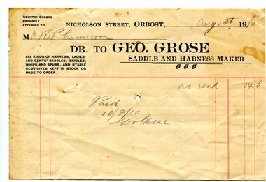
accounts, 1910 1911
Robert Pullar Cameron was a Shire Councillor for many years. He married Penuel Hossack and had a family of James, Flora, Penuel and Alex.This item is an example of book-keeping in the early 20th century an is a useful research tool.Two white paper accounts - black print and hand-written details. Both are from George Grose, saddle and harness maker to R. Cameronon front - "Paid 10/8/10 Geo. Grose" "Paid 11/10/11 Geo. Grose"account-book-keeping cameron-robert-pullar grose-george -
 Ringwood and District Historical Society
Memorabilia - Envelope, Packet: Ringwood Methodist Church - Anniversary Pamphlets, Cuttings, Pictures, Hand written notes
Churches - Ringwood Methodist Church3785.1 A hand written notes of the early history of the church. Several to the Town Clerk from the Ringwood Church trust and thr Public health department. 2. Minutes of meeting of the Ringwood Parsonage Trust 1909 and 1910 3. The Record of the Box Hill and Ringwood Methodist Circuits. Hand writen list of members of Ringwood Circuit. 4. Flyer for Back to Ringwood Methodist Church Jubilee, March 9th to 17th. 1929. Letter to Richard Carter from Aub (sic) who was eight years old at the time and can remember the Jubilee 4 Booklets about the Church Also a name tag for Miss V. Watson Assist. Secretary. Several cuttings, one full page spread from the newspaper about the Jubilee. 5. Ringwood Methodist Sunday School Tea and Meeting. Cutting from the Ringwood & Croydon Mail. The Wigley family were greatly represented. 6. Diamond Jubilee 17-28th. March ,1939 Program of Events 7. Six pages of hand written letters from the Methodist Circuit, letter to the Ringwood Councillors inviting them to the Centennary Celebrations of the Church,letter to the Town Clerk from Methodist Sunday School Surrey Hills regarding a picnic in Ringwood. 8. Ringwood United Churchmen's Association syllabus 1937 9. Pamphlet about Sunday Sport and the Christian Duty to Vote. 10.Ringwood Methodist Church news July 1963 11. Two Ringwood Methodist Church pamphlets for the 75th. Anniversary March 17th.-28th. 1954. 12.Copy of lease from the Methodist Church Trust for 30 years to use land in Ringwood 13. Carols by Candlelight (no year) and the Ringwood Methodist Church News March 1958, With memories of Christmas. 14.Pamphlet of the Laying of the Foundation Stone Saturday 18th. May 1963 and two pamphlets of the Opening and Dedication of the Ringwood Methodist church 9th. november 1963. 15.'The Messenger' Journal of the Ringwood Methodist Church December 1963. 16'. Forward in Faith' Review Stewardship Canvass August 1961. 11 pages outlining the plans for the proposed new Church. 17. Foolscap sheet typed with the Evening Service Sunday 6th. December 1970 with the Combined Circuit Choirs .Excerpts from 'The Messiah' 18. 'Recollections of Ringwood Methodism' issued at the celebration of the 98th. Anniversary of the Church 29th. may 1977. Compiled by Alf. Clark 19.Syllabus for the Uniting Church Fellowship Ringwood 1984 20.' Methodist Pioneers in the Croydon Area'. Work in Progress by Rev. Barry Brown 21.two page history of the ' Pipe Organ in the Ringwood Uniting Church' which was built by the Melbourne firm of Geo. Fincham & Sons. Plus a pge with' A Few Facts about the Organ' 22. Two Church Christmas cards (no year). one in envelope -
 Ringwood and District Historical Society
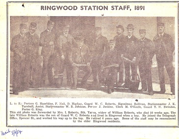
Newspaper - Clipping, Ringwood Railway Station Staff 1891
Appeared in the Ringwood Mail 5th August 1954Newspaper photo of the Railway Station Staff, Ringwood, Victoria, Australia in 1891. Clipping from The Mail newspaper, 5 August, 1954. Porters G. Hazeldine, F. Neil and D. Mackay, Guard W.C. Roberts, Signalman Sullivan, Stationmaster J.K. Turnbull, Asst Stationmaster W.B. Johnson, Porter J. Jenkins, Clerk M. O'Keefe, Guard T.H. Swindon and Porter G. King.Clipping includes caption: This old photo was forwarded by Mrs. I. Roberts, Sth. Yarra, widow of William Robers, who died 10 weeks ago. The late William Roberts as the son of Guard W.C. Roberts and lived in Ringwood when a boy. He joined the Telegraph Office, Spencer Street, and worked his way up to the top. He retired 6 years ago. Some of the staff may be remembered by the older Ringwood residents. -
 Ringwood and District Historical Society
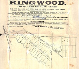
Flyer, Land Sale Advertisement, Ringwood, Victoria - 1894
Land sale advertisement for 10 and 20 acre lots from £5 per acre on eight years' terms in Ringwood, with description of local facilities and agricultural features.Subdivision map includes Mullum Mullum Road, Wonga Road, Oban Road and Anderson's Creek Road (later Warrandyte Road). Markings on reverse side indicate the sheet was sent by post from John McEwan & Co., Auctioneers, Land Agents & Business Brokers, 71 Swanston Street, Melbourne, to Mr Allan, Builder, Ringwood, postmarked in JE (June), 1894. -
 Orbost & District Historical Society
display cabinet and tools
This display was put together by the Curlip Committee and used as promotion in the shed during the construction of Curlip 11 A community project, this boat was constructed out of local hardwood timbers utilizing the traditional skills of wooden boat builders and is powered by a steam engine. Paddle Steamer Curlip II is a replica of an historic paddle steamer of the Snowy River, in Far East Gippsland, Victoria. The original Paddle Steamer Curlip was built by Sam Richardson and his sons Mark, Albert and Frank, at their sawmill at Tabbara, a pioneering settlement on the Brodribb River, a tributary of the Snowy River. The keel was laid on 14th October 1889 and PS Curlip was launched in 1890. The name “ Curlip” is derived from the indigenous name for the area where Tabbara is located and includes land to the east of the Snowy and Brodribb Rivers towards Cape Conran. PS Curlip was registered in 1893 and the Passenger Certificate issued on 30th January 1903 to Captain Alan Richardson by the Marine Board of Victoria entitled her to carry 25 passengers and only 10 passengers when engaged in towage service. Two children under 12 years of age to be reckoned as one passenger. PS Curlip towed five barges at a time, traveling upstream as far as Bete Bolong, 20 km upstream of the mouth to collect produce to be transferred to schooners near Marlo. She towed vessels in and out through the Snowy river entrance and was also used for social functions such as Sunday School picnics. She was the main means of transport for imports and exports on the Snowy River for almost 30 years. The Curlip era ended abruptly on Friday 28th February when a flash flood carried her and 2 barges down river and out to sea, where she washed ashore at Marlo and broke up.More than eighty years after the original Paddle Steamer Curlip was wrecked at sea, the Orbost community launched a replica which it hoped would draw tourists to the region. The P.S. Curlip II, is based on drawings of the original Curlip that made its home in the Snowy and Brodribb Rivers of East Gippsland in the 1890s and early 1900s, It took six years of planning and hundreds of hours of volunteer work from the local community.A display cabinet containing tools and sundry items related to the Paddle Steamer Curlip. (More information on individual items in Catalogue 1400-1600)p.s.curlip richardson-samuel boat-building-tools transport -
 Orbost & District Historical Society
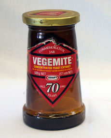
jar, 1993
A young chemist named Dr. Cyril P Callister, hired by the Fred Walker Company, developed a new spread from brewer’s yeast. It was claimed as the richest known sources of natural Vitamin B. Labelled as ‘Pure Vegetable Extract’, it was sold in a two ounce amber glass jar and capped with what was known as a Phoenix seal, to keep the contents fresh. A competition inviting the Australian public to create a name for the new spread offered a prize of 50 pounds. finalists. Hundreds of people entered and Fred Walker’s daughter selected the winning name: VEGEMITE. The name of the winning entrant was never placed on record. VEGEMITE spread was then sold from grocers’ shelves. In April 1984, a 115-gram jar of vegemite became the first product in Australia to be electronically scanned at a checkout A commemorative jar was produced to celebrate the occasion of 70 years - 1922-1997.Vegemite is possibly Australia's most iconic food brand. Since the 1930s it has been a major part of this country's cuisine. Yet unlike other Australian icons the attraction of Vegemite has remained local. A tapered brown glass jar with a gold metal lid. The label o the front is red with yellow, white and black print. there is a similar smaller label on the lid. with black writing.On base: a spiral with 10 in centre circle 13573 underneath the spiral above is letter A with raised dots insidevegemite jar -
 Ringwood and District Historical Society
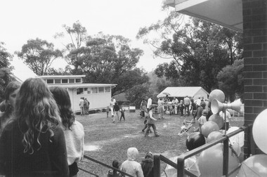
Photograph, Ron Mason's coach at North Ringwood State School 50th year celebrations, 20/10/1973
... State School for 50 years 'Do', 20/10/73"...., "Coach at North Ringwood State School for 50 years 'Do', 20/10/73 ...Written on back of photograph, "Coach at North Ringwood State School for 50 years 'Do', 20/10/73". -
 Ringwood and District Historical Society
Photograph, North Ringwood State School 50th year celebrations, 20/10/1973
... 50 years 'Do' - 20/10/73"...., "North Ringwood State School 50 years 'Do' - 20/10/73". North ...Written on back of photograph, "North Ringwood State School 50 years 'Do' - 20/10/73". -
 Orbost & District Historical Society
ticket, 1987
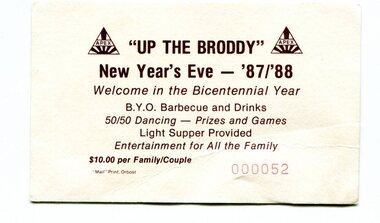
This ticket was for an entertainment at Brodribb for the celebration of the incoming bi-centennial year, 1988. The bicentenary of Australia was celebrated in 1988. It marked 200 years since the arrival of the First Fleet of British convict ships at Sydney in 1788. Many events were organised to celebrate the occasion.The Apex Club of Orbost was a volunteer service club which contributed to the Orbost community. A declining population has led to the demise of many social groups in the area. The Apex Club, like other groups in Orbost have organised social events for the local community for many years.A rectangular shaped cardboard ticket coloured white/cream. On the front in brown print is " APEX 'Up the Broddy' new Year's Eve - '87/88 WElcome in the Bi-Centennial Year BYO barbecue and drinks. 50/50 dancing - prizes and games. Light supper provided. Entertainment for all the family. $10 per family/couple". In red is 000052.celebration bicentennial-celebration-orbost -
 Cheese World Museum
DVD, Heywood Cheese; an oral history on film
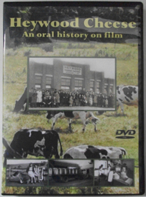
For many years the Heywood Cheese Factory was an important part of life for Heywood and district farming and a vital place of employment for up to 40 men and 10 women. The factory opened in 1939 as a subsidiary of the Portland Butter Factory before becoming a world renowned cheese making enterprise. It was felt important to document its history from the surviving factory workers, including dairy suppliers and milk truck drivers. We hear their stories of the long hours and hard work without penalty rates, travelling unsealed roads and mixed with their humour of the bygone days is an important acknowledgement of that era. [blurb on back cover]This oral history provides significant material relating to the dairy industry in south west Victoria during the mid 20th century. The interviews give first-hand recollections of the interviewees involvement in the industry from a point of view of factory workers, milk pick-up drivers and farmers.Full colour DVD cover has photograph of Heywood Cheese factory and photographs of girls with calves, milk cans on a truck and workers in the cheese room, superimposed on a photograph of dairy cows grazing in a paddock. The DVD has the photograph of the cows grazing in the paddock.Heywood Cheese/An oral history on film (front) For many years Heywood Cheese Factory was ... [see historical information] Edited by Garry Kerr for the Heywood Pioneer Wagon Shed/ Museum History Group who wish to gratefully acknowledge the/ support of the Victorian Government and Public Records Office/ Victoria for making this project possible. Duration: 70 minutesallansford, heywood, cheese factories, cheese manufacturing, dairying, cheese -
 Flagstaff Hill Maritime Museum and Village
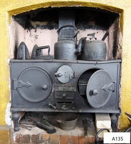
Domestic object - Stove, First quarter of the 20th Century
The first Australian cast iron stove was made by Charles Andrews in 1877 he patented his design and called it the “Andrews Nonpareil stove.” That for many years was the only Australian made kitchen stove on the market. When his patent expired numerous imitations were manufactured by other firms but the Nonpareil continued to earn a reputation for quality, economy and excellent cooking. The company operated at 47-10 Gheringhap Street Geelong, Victoria, they also specialised in hot water generating services.The subject item is significant as a copy of the well known design for the original Nonpareil stove by Charles Andrews. The name Andrews Nonpareil in stamped on the flue however the doors on the stove front are wrong and indicate the item is a copy by an unknown manufacturer probably made in the first quarter of the 20th century. Stove cast iron on 4 legs, two oven spaces with round doors. On flue "Andrews Patent Nonpareil".On flue "Andrew Patent Nonpareil"flagstaff hill, warrnambool, shipwrecked coast, flagstaff hill maritime museum, maritime museum, shipwreck coast, flagstaff hill maritime village, great ocean road, stove, iron stove, andrew patent nonpareil, cooking appliance, oven, combustion oven, cooker -
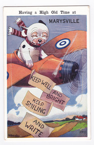 Marysville & District Historical Society
Postcard (item) - Novelty postcard, Having a High Old Time at MARYSVILLE-KEEP WELL AND BRIGHT KEEP SMILING AND WRITE, 1940's-1960's
A novelty postcard with pull-out strip of 9 miniature photographs that was produced by the Valentine Publishing Co as a souvenir of Marysville.A novelty postcard with pull-out strip of 9 miniature photographs that was produced by the Valentine Publishing Co as a souvenir of Marysville.Having a High Old Time at MARYSVILLE KEEP WELL/ AND BRIGHT/ KEEP SMILING/ AND WRITE 1902 VALENTINE'S/ MAILING NOVELTY From VALENTINE'S "MAIL NOVELTY" POSTCARD. COPYRIGHT/ PRINTED IN GT. BRITAIN To Dear Mrs Bannan, I was expecting/ you down to meet "my folks" while they/ were over. Sorry you couldnt fit it in/ They went back last Tuesday & we came/ up here on Wednesday. Weve settled in/ to have a restful holiday. its a lovely/ place spotlessly clean & beautiful meals/ Ive never eaten so much for years. We/ will be here for 10 days so I should put/ on at least a stone the way Im eating/ love & best wishes to you all from Wm Staceymarysville, victoria, postcard, souvenir, valentine publishing co, crossways cabaret (image 1), taggerty river (image 2), acheron way (image 3), blacks spur road (image 4), nicholl's lookout (image 5), main street marysville (image 6), sugarloaf bay eildon (image 7), steavenson falls (image 8), cumberland falls (image 9) -
 Marysville & District Historical Society
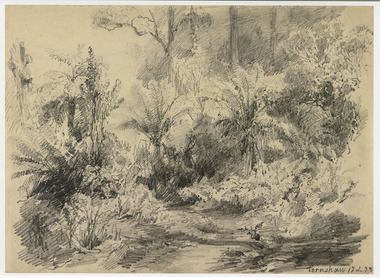
Artwork, other (Item) - Pencil Sketch, Louis Buvelot, Fernshaw 17.2.83, 1883
A copy of an early pencil sketch of Fernshaw in Victoria.A copy of an early pencil sketch of Fernshaw in Victoria by Louis Buvelot. Louis Buvelot ( 1814–1888), born Abram-Louis Buvelot, was a Swiss landscape painter who lived 17 years in Brazil and following 5 years back in Switzerland stayed 23 years in Australia, where he influenced the Heidelberg School of painters. Arriving in Melbourne in February 1865, after leaving the cold of Switzerland, which was impacting on his health, for the warmth of Australia, Buvelot was in business as a photographer in Bourke Street for a year but soon resumed his painting. He lived in Melbourne for a number of years before moving to Fitzroy. The National Gallery of Victoria purchased two of his paintings and he continued painting until his death in 1888. He was buried at the Boroondara Cemetery, where a large monument was erected in his memory. Fernshaw was a rural township 63 km northeast of Melbourne and 10 km northeast of Healesville. Situated on the Watts River, near where a log had fallen making a convenient crossing, Fernshaw was settled in the 1860s. It provided good country for orchards and berry growing. The location was at the foot of Blacks Spur, with Mounts Juliet and Mondah rising on either side, providing spectacular scenery. There were nearby fern gullies giving rise to the name – ‘shaw’ is old English for thicket or wood. By 1875 Fernshaw had a post office (1865), two hotels, a school (1871), and stores. It was famed for its beauty, attracting tourists. In 1886 the Melbourne and Metropolitan Board of Works began work on the Watts River water catchment scheme – later to become Maroondah – and the Board obtained approval for the catchment country to be reserved and kept free of settlement. This required the removal of the Fernshaw township, which was completed by about 1890.Fernshaw 17.2.83louis buvelot, fernshaw, victoria, national gallery of victoria, switzerland, boroondara cemetery, kew cemetery, artist -
Federation University Historical Collection
Document, Zelda Martin, Central Victorian Goldmining towns - Boom Towns or Ghost Towns?, c1996
Zelda Martin was a PhD candidate at the University of Melbourne.[.1] 4th item in light blue display book titled Research Approach/Overview of Chapters/Confirmation of Canditure/Chapters1,2,3&4 of proposed thesis. *Twenty-seven page article on Victorian goldfields towns titled: Central Victorian Goldmining Towns - Boom Towns or Ghost Towns. The article was written during the author's PhD study. It outlines the context methodology, and resources and the chapters of the proposed thesis: (1) Central Victorian Goldmining Towns - The Context (2) Contemporary Views of the Factors Necessary for Town Growth (3) Outward Manifestations of Town Growth (4) The Trappings of Government (5-9) The Main Towns and Their Hinterland. [.2] 5th item in Light Blue display book as above item. *Chapter 1 of proposed thesis titled 'Pick, Shovel and Tin Dish Mining.' Covers in Section A: Central Victoria - Pre 1851: Aborigines in Central Victoria, Squatters, and Government. Section B: The years 1851-1854: The Early Gold Rushes, Government Reaction, Township Surveys, Legislation, Town Development, Local Government and Early Settlement. [.3] 6th item in Light Blue display book as above item. *2A of proposed thesis titled 'Contemporary Views of the Factors Necessary for Town Growth'. Similar information to Chapter 1 plus extra re towns and maps. Sections: Introduction, Context of Place - Geographical Towns Listed, The Context of Time - Pre1851 Aborigines, Governance of Port Phillip, The Squatters, The Villages of Central Victorian Highlands, Conclusion, Condensed Version of Chapter2B. [.4] 7th item in Light Blue display book as above item. *Chapter2B of proposed thesis. Sections: Area of Research, Schools, Banks, Newspapers, Progress Association, Town Development - Sandhurst (Bendigo), Ballarat, Castlemaine,, Maryborough, Ararat and Stawell. [.5] 8th item in Light Blue display book as above item. *Chapter 3 of proposed thesis titled 'Outward Manifestations of Town Growth'. Sections: Introduction, Contemporary Writing, Educationalists, The Bankers, The Townsfolk, Current Theory, General Theories of Urban Development, and Conclusion. [.6] 9th item in Light Blue display book as above item. *Chapter 4 of proposed thesis titled 'Trappings of Government' Sections: Introduction, Early Government Attitudes to Mining and Town Development, Law and Order, Township Surveys, Legislation, Local Government, Transport and Communication, The People and Lobbyists. [.7] 10th item in Light Blue display book as above item. *'The Rise and Fall of Central Victorian Goldmining Towns'. Includes a map showing main Goldfields, a table showing towns and villages at two points in time - 1857 and 1871; a Bibliography of Primary and Secondary Sources. [.8] Resource No1. Black display book titled Local Towns 1 : Alma: *Brief history *Directory *Maps Amphitheatre / Mountain Hut: *Brief History Post Office Directory Ararat: *Brief History *Post Office Directory 1869 - Alphabetical Listing by Occupation *Ararat - Prominent Citizens of 1858 *Langi-Morgala Museum Avoca: *Brief History *Excerpts from 'Avoca The Early Years', Margery and Betty Beavis; pg1 - Beginnings; pg11 - The Midas Touch; pg25 - Local Gold Escorts; pg27 - A Town is Born; pg51- The Administration of Justice; pg53 - The Ways of the Law; pg61 - News of the Day; pg65 - A Time to Play; pg72 - Land Ownership *Post Office Directory (Bailliere's) 1869 *Tourism Map and Information of area *Historic Avoca - A 5.5km Tour *Avoca & the Pyrenees Region - information pamphlet Ballarat: *Early History of Ballarat - Ballarat Historical Society, Publication No.1: origin of the name; Ballaarat - the Beginning; Fabulous Yields from the Ballaarat Goldfield; *Streetscape Lydiard Street. *Hand drawn map showing Leigh River, Old Portland Bay Road, plaque on road to Colac; etc. *Newspaper article re 'The Theatre Royal' ( which stood in the vicinity of the current Owen Williams store) - 'The News'15/04/1998 *Article - 'Ballarat's Mechanics' Institute Lives On' Ballarat Courier, 14/09/1985 *Article - Standing the Test of Time' The News 17/11/1993 re The Mechanics Institute & picture of the Reading Room *'Ballarat a Study of a City, Phyllis Reichl, pub. Nelson, 1968; no.3 place, time and people field studies series *Investigator Vol.33 No.2, 1998 Geelong Historical Society. Article on pg75 describes Ballarat in 1861 *Folded poster - 'Ballarat 100' a history of telegraph communication, pub. Telecom. Beaufort (Fiery Creek): *Brief history *Post Office Directory [.9] Resource No.2 Black Folder Titled Towns cont.No2 Bendigo (Sandhurst): *'Family & Local History at the Bendigo Library - 1851-2001 150 years of gold'. *Bendigo Government Camp in 1853 illustration; key to sketch and names of Government officers stationed there *Excerpts from 'Bendigo and Vicinity' Adolph Haman *The Bendigo Goldfield Registry - pgs 1-7 Introduction *Excerpt: 'Breaking the Grip' *Excerpt: The Most Go-Ahead Place *Excerpts from 'History of Bendigo' - anti license agitation; laying out of town; proposed railway; gold calls and dividends; the Sandhurst Municipality; journalism *Bibliography Blackwood: *Excerpts from 'Aspects of Early Blackwood - The Goldfield, the Landmarks, the Pioneers' Alan J Buckingham and Margaret F Hitchcock, JG Publishing,1980 Buninyong: *A Brief History *Investigator Vol1 No.2 Feb 1966 Geelong Historical Society. Pg3 - Article re gold escort route - Mt Alexander to Adelaide - (see a simple monument on the Western Highway a few miles out of Horsham. Pg 15 - Ballarat Excursion - re the finding of gold. *Three articles published by Buninyong and District Historical Society Inc: (Magpie Exploration; Finding Gold In The Green Hills; Magpie Exploration; Burnt Bridge to Cargarie to Mt Mercer) *Copies of newspaper articles/items *Buninyong Street Directory Carisbrook: *In the Beginning There Was Carisbrook *The History of the Carisbrook Racecourse Carngham / Snake Valley: *Brief History *Directory Castlemaine: *Directory 1865-1866 - Alphabetical and Street *Poster - Castlemaine A Contemporary Guide "The Great Centre" 1866 - A Contemporary Guide to the Fascinating Past *Pamphlet - Castlemaine District Community Hospital *Map - Castlemaine, Maldon & Surrounding Districts *Map and Information - The Dry Diggings Track - a 55kl walk among historic goldfields relics ( Castlemaine Fryerstown Vaughan Mt Franklin Hepburn Daylesford) *Postcard - Former Court House *Directory 1867 - Alphabetical, Trade [.10] Resource No.3 Grey folder Titled Towns 3 Creswick to Maryborough Creswick: *Brief History *Booklet - "Creswick Cemetery Walk" *Booklet - The Buried Rivers of Gold Heritage Trail Creswick *Creswick Historical Museum Information Sheet *Chronological History of Creswick *Alphabetical Directory of the Borough of Creswick *Creswick's Creek Directory 1856 *Historic Creswick Walking Tour *A Brief Account of the Schools of Creswick - Past and Present *100 Years of Railway Travel in Creswick *The Berry Deep Leads *The Spence Home at Jackass Gully in the Creswick State Forest ( William Guthrie Spence - Pioneer) *The New Australian Mine and the 1882 Disaster *Creswick District News, Issue 7, July August 1999 *The Creswick Miners Walk - Information and Map *Maps Chewton: *Brief History *Directory Clunes: *Brief History *Clunes Street Directory Daylesford: *Brief History *Notable Bushfires in Daylesford District Over More Than a Century - "Black Thursday" 1851; 1862; 1899; the Disastrous Hepburn Fire of 1906; 1939; 1944; 1969. *Post Office Directory -Daylesford and Hepburn Dunolly / Inkerman: *Brief History *Directory *Pamphlet - Goldfields Historical Museum *Pamphlet - Historic Dunolly - Victoria's Best Kept Secret *Map of Gold Workings at Dunolly Area - showing where the main gold rushes occurred *Brief History - Inglewood *Directory - Inglewood - Name Occupation, Dwelling Kingower: *Brief History *Directory - Name / Ocupation / Dwelling Linton / Happy Valley / Piggoreet: *Brief History *Directory - Lintons McIvor: *"A History of the Shire and the Township of Heathcote" by J.O. Randell Majorca: *Brief History *Official Post Office Directory 1869 - Name / Occupation/ Address Maldon (Tarrangower): *Brief History Part 1 *Brief History Part 2 *Post Office Directory *List - Alphabetical Order by Names plus Business and Trade (Tarrangower Times Oct/1858) *List - Alphabetical Order by Trade plus Name and Business *Directory - Name / Occupation / Dwelling Maryborough: *Worsley Cottage - built by Arthur Worsley, a contractor in stonework in 1894 [.11] Resource No. 4 Blue Display Book titled Towns 4 Moliagul to Stawell Moliagul: *Brief History *Moligul Legislative Assembly (Voting?) List - Names and Occupations *Moliagul Victorian Post Office Directory 1868 - Name / Ocupation / Address / Comments *"The Welcome Stranger" gold nugget *The Sunday School *The Welcome Stranger Discovery Walk - information and map Moonambel (Mountain Creek) Redbank *Brief History *List of names extracted from advertisments of the Pioneer and Mountain Creek Advertiser 16/02/1861. *Bailliere's Directory 1869 - Alphabetical List of Name / Occupation / Place St Arnaud: *Brief History Sebastapol: *Brief History *Directory 1869 - Alphabetical by Name; plus occupation and address. Browns and Scarsdale: *Brief History *Browns Street Directory - Name and Occupation Smythesdale: *Brief Description *Smythesdale Street Directory -Name and Occupation Stawell (Pleasant Creek) *Brief History *Victorian Official Post Office Directory - Name /Occupation / Dwelling *Chronology - 1841-1920 *Production of gold statistics - 1879 - 1900 *Big Hill *Extracts from "The Golden Years of Stawell". Chapt 1 - Stawell's Coming Out. Capt. 2 - The Gold Rush. Caapt.3 - Cradle of Democracy. Chapt.4 - The Reefs Becomes Stawell. Chapt. 5 - Rushing In. Chapt.6 - The Pioneers. Chapt 7 - The Decade of Optimism. [.12] Resource No. 5: Blue Display Book titled 'Towns Steiglitz to the The Golden Triangle. Steiglitz: Brief History Victorian Post Office Directory 1869 *Map of Steiglitz *List of maps relevant to Steiglitz history *Information 6 tables of data from "Reports of Mining Surveyors Talbot (Back Creek) Brief History Taradale: Post office Directory 1869 - Name/Occupation/Street. Also list in alphabetical order by Occupation Taradale *Chronological Reference to Taradale Mines *Water - The Coliban System of Waterworks *Joseph Brady *The Syphon Tarnagulla (Sandy Creek) *Brief History *Tarnagulla Businessmen Cameos to give depth to advertisments in 'The Tarnagulla Courier' various issues 1864-1871 *Directory - Name/Occupation /Address *List - Name/Business/Trade Wedderburn (Koorong) *Brief History *List - Name/Occupation The Golden Triangle: *The Early Rushes - Wedderburn / Moliagul / Sandy Creek - Tarnagulla / Jones Creek - Waanyarra / Kingower / Dunolly - Goldsborough / Inglweood *Census of 1857 - Population / Occupations *1858-1871 - A Time of Consolidation- Wedderburn / Moliagul / Sandy Creek- Tarnagulla / Arnold *Census 1871 - Population *Information gleaned from the census data - Demographics / Population / Occupations / marital / Birthplace / Religion / Literacy/ Occupation and Housing Cameos *Graphs - Birthplace of settlers /Male-Female Ratio / Married males / Children under 15 as Percentage of Population / Religion *Census 1857 - Statistical data *Maps *Bibliography [.13] Resource No. 6 - Black Display Book Information and Research in Central Victoria including: *Banking - Research from ANZ Bank Archives *Institutions - also includes articles listed from the Ballarat Times Newspaper *Australian mining History Association - A.M.H.A. Bibliography *Australia's Mining History * Bibliography - Land Surveys Victoria - *1853 Administration (Statistics and Other) includes: schools / ministers of religion / police / military / local administration / licences for sale of spirits / distances between various Victorian gold fields. * Victoria Government Gazette (Copy) - N0. 116, 12/12/1854 includes: Gold Felds Commission of Enquiry & No. 85, 15/09/1854 - Addresses presented to the Lieutenant Governor (Sir Charles Hotham) during his tour through the Gold Fields of Victoria,1854. Addresses on behalf of : the people of Bendigo; Members of the Church of England, Bendigo; Members of the Wesleyan Church on the Bendigo Gold Fields; Bendigo Gold District General Hospital; the Bendigo Prospecting Association; Committee of the Bendigo Local Exhibition; Bendigo District Medical Association; Coloured Americans Resident at Bendigo; German Inhabitants of Bendigo; Landowners, Inhabitants, and Miners of Castlemaine; Inhabitants of Forest Creek; Inhabitants of Heathcote and Gold Miners of McIvor; Residents and landholders of the District of Bacchus Marsh; Inhabitants of Kilmore and Vicinity. *Gold Fields Correspondence 1853: letter from Lieutenant Colonel Valiant, (Officer commanding the Troops in Victoria) to the Lieutenant Governor re threatened disturbance at Sandhurst (Bendigo) regarding the Gold License Fee. * Extracts from a book "Victoria" re Gold Fields Commission of Enquiry involving mainly Ballarat and Castlemaine and a chapter titled 'A Tour to the Victorian Gold-Fields' *Lists of central Victorian newspapers - listed by date published 1851to 1874; by first date available to State Library. *A list of cities and towns showing County, population in 1861 &1871, and municipal status. [.14] Resource no.7. Black display book. *Reference: Papers presented to Parliament Victoria - 1859-1860 4 volumes - relevant sections copied. Contains information on Branches of Government. General / Finance / Gold / Gazette / Commission and Warrant / Statistic. *Gold Fields Act. In accordance with the Act the gold fields are divided into six districts - Ballaarat, Castlemaine , Sandhurst, Avoca, Ararat, and Beechworth.. Official staff in each gold district consists of a Resident Warden, Wardens, Wardens' Clerks, Bailiffs, Chinese Protectors, Chinese Interpreters, and Mining Surveyors. *Gold Receiver *Gaols *Police magistrates and Clerks of Petty Sessions, etc. *Field Branch *Immigration and Emigration Overland - Chinese - 1859 *Population on the Goldfields *The Geological Survey - The Government Geologist is assisited by staff from four branches - the office Branch; the Publishing Branch; the Field Branch and the Museum Branch. *Commission to Enquire Into Sludge dated 10/02/1859 (Some sections copied) - Report to the Honorable Chief Commissioner of Public Works, Melbourne re the mode of carrying the sludge from the puddling mills in Sandhurst without interfering with the drainage of the town and the roads in the neighbourhood. [.15] Resource No.8: Camel display book titled Resource No. 8. Aborigines *Lists of book titles - +"Readings in Victorian prehistory" +"The Aborigines of Port Phillip" +Aboriginal languages and clans" +"A History of the Port Phillip District" +"Langi Ghiran 1: Aboriginal Rock...." +"Koorie History: sources for aboriginal studies in the State Library of Victoria", ed. Tom Griffiths, Melb. Friends of the State Library, 1989 +"The Public Lands of Australia Felix"; settlement and land appraisal in Victoria1834-91 with special reference to the Western Plains", J.M.Powell, Melb. Oxford University Press 1970 +*Bibliography of the Victorian Aborigines' from the earliest manuscripts to 31st December 1970, Massoa, Aldo, Melb. Hawthorn Press, 1971 +"Aborigines in Colonial Victoria, 1836-1886", M.F. Christie, Sydney University Press, 1979 +"Urban and Industrial Australia: readings in Human Geography" ed J.M. Powell, Melb. Sorrett Pub. 1974 *Extracts: -Processes of Pioneer Settlement - The Squatting Occupation of Victoria, 1834-60. J.M. Powell -Areal Variations in the Class Structure of the Central-Place Hierarchy. P. Scott - Volume1 and Volume 2: Notes Relating to the Habits of the Natives of Other Parts of Australia and Tasmania. Compiled from various sources for the Government of Victoria by R Brough Smyth. John Curry, O'Neil, Melb. 1st pub. Melb. 1876. p31-45 - Numbers and Distribution of the Aborigines in Victoria -Victorian Aborigines 1835-1901 - A Resource Guide to the Holdings of the Public Record Office, Victoria; published by the Government Information Centre 1984. *History of the Aboriginal Artefacts Displayed in the Daylesford Museum. F. G. Powell (4 page pamphlet) *Letter to Zelda Martin from Peter Lovett, Cultural Officer, Ballarat & District Aboriginal Co- Operative, 05/02/1997 *Map: Ian Clarke Victorian Tribunal Boundary Map - Clans of Central Victoria. *Victorian Rock Art and Mythology - Article about Mount Langhi Ghiran and myths of the Tjapwarong people. *Two Aboriginal myths relating to the Grampians - 'The Monster Emu' / 'The Aquisition of Fire', by the Aborigines in the Grampians Areas *Article titled (chapter 8) Ballarat - information re camping sites in the region. Lake Wendouree / Lake Burrumbeet (includes a myth) / Mt Bunninyong / Lal Lal / Pitfield / Mount Elephant / Mount Egerton / Meredith / Lake Goldsmith / Lake Learmonth / Ercildoune *Notes on the Aborigines of the Wider Ballarat Region plus European names=Aboriginal names. John Morris 26/07/1995 *Role of Aborigines in Town Development in Central Victoria. Mentions Native Police Force est. in Port Phillip 1842 and Central Board for Aborigines est. 1860 *The Grave of King Billy. (Frank Wilson) Pamphlet. *Camping Places in Central and Northern Victoria. Article re Lake Burrumbeet site. *Programme for the Unveiling of Memorial Cairn for Edward Stone Parker 1802-1865. Note portrait not accurate. Accurate portrait is available in the book "A Successful Failure A Trilogy The Aborigines and Early Settlers", Edgar Morrison, Graffiti Publications, 2002. * Large envelope addressed to Mr G Netherway containing newspaper cuttings regarding the life of Edward Stone Parker, the unveiling of the Memorial Cairn as mentioned above, articles titled 'Episodes from Our Early Days' (Edgar Morrison, Yandoit)- The Black's School, A School At Last and The Final years. Also a typed page titled 'Historical Background to E.S.Parker's Career. Includes an interesting tale titled 'When the cat lay doggo' re laying power leads for the unveiling ceremony at the memorial site. [.16] green display folder titled 'Research Aids' *List of references to Commissioners' & W'ardens' Reports (formerly held at La Trobe Library Archives, now at Public Records Office [PRO]). Indicates town referred to / date of report / name of camp if different to town. * Archive information re Anglican Records *Movement around the Goldfields - Miners and Storekeepers - usefulness of newspapers in providing information - areas covered - Castlemaine, Maldon, Ararat, Stawell, Tarnagulla, Dunolly. *Port Phillip /Victoria Directories 1839/1867 - Chronological list of Directories included in this series. *"Notes on the History of Local Government in Victoria" A.W. Greig Melb. University Press 1925 - Photo-copied extract p5-p40. (Source - Deakin University Library) - Introduction by W.Harrison Moore. Section 1 - Development in New South Wales Before Separation. Section 2 - Development in Victoria After Its Separation from New South Wales. Hand written notations: 'roads, markets, and local government 1855 on' ;'opportunity of squatters in parliament' and 'opportunities of matters in parliament p33' * Notes on the Establishment of Surveyor General's Department 1851and Commissioner of Crown Lands and Survey. * Newspaper articles from The Argus, 1849, re the discovery of gold in the Pyrenees region. * Excerpt - a report on schools - A.B.Orlebar, Inspector; re the need for permanent school buildings rather than tents. *Excerpt from - 'Approaches to Urban History', Sean Glynn: The Case for Caution * Except from - 'The Urban Sprinkle', Weston Bate: Country Towns and Australian Regional History *Reference- 'The History of Land Tenure in the Colony of Victoria', John Quick. References the Haines Land Bill, land tenure and Land Leagues. [.17] Light blue envelope folder titled 'Birtchnell's Ballarat, etc. Directory 1862 *Contains various directories for Smythesdale, Buninyong, Clunes, Brown's and Creswick. [.18] Red envelope folder no.2 titled Victorian Gazetteer *Selected pages from 1869 Victorian Gazetteer on A4 paper (with a handwritten note questioning if some pages are from 1868 Victorian Gazetteer as appears to be different sizes - A3 pages.) Information includes locations and descriptions of towns, hotels, banks, communications and populations. (Does not include names, residences and occupations) [.19] Red Envelope folder titled Bailliere's Official Post Office Directory 1868 (or1869 or a mixture of both?) *Preface *Contains a selection of pages of towns highlighted in yellow in the the index *Work on this directory was commenced in 1867. *Information includes: Municipalities - mayors and councilors; lists of towns naming male inhabitants and their occupations. [.20]Yellow manila folder titled Post Grad Seminar Presentation 1996 *Gives some background to Zelda Martin's proposed thesis and why she chose the topic Gold Mining Towns Boom or Bust [.21] A3 display book - No. 1A * A list of 'Relevant Newspapers collected: The Tarrangower Times and Maldon Advertiser (first published 1858) Includes dates 1858-1867. The Mount Alexander Mail. Includes dates 1854-1866 The Tarnagulla Courier. Includes dates from1864-1871 Dunolly and Burnt Creek Express. Includes dates from 1862-1871 * Selection of newspaper pages from The Mount Alexander Mail 1854 to 1856, mostly showing advertisements for businesses and services provided to that community. [.22] A3 display book - No. 1B * Selection of newspaper pages from The Mount Alexander Mail 1857 to 1866, mostly showing advertisements for businesses and services provided to that community. [.23] A3 display book -No. 2 * Selection of newspaper pages from The Tarnagulla Courier 1864 to 1871, mostly showing advertisements for businesses and services provided to that community. [.24] A3 display book - No. 3 *Selection of newspaper pages from The Tarrangower Times (and Maldon and Newstead) Advertiser 1858 to1867, mostly showing advertisements for businesses and services provided to that community. [.25] A3 display book - No.4 * Selection of newspaper pages from The Dunolly and Burnt Creek Express; and The Dunolly and Betbetshire Express 1862 to 1871, mostly showing advertisements for businesses and services provided for that community. [.26] A3 display book - No.5 Includes: * Bryce Ross's Diggings Directory. Includes instructions for using this directory. This directory was used by "all persons having connexion or desiring to communicate with 'working parties, private friends, or Stores at the Diggings." As a directory for each area wwas completed it was published in each month's issue of Bonwick's "Digger's Magazine." Years c1852/1853. This Directory commences first at the head of Forest Creek. Includes a directory for Bendigo and Ballarat. Of interest at the end of the Bendigo and Ballarat directory is a list of the number of storekeepers, butchers, doctors, smiths, eating houses, lemonade sellers and chapels. * The Castlemaine Directory and Book of General Information Comprehending Glass's Model Calendar for the Two Years 1862 and1863. "zelda martin, victorian goldfield towns, bendigo, castlemaine, ballarat, maldon, stawell, ararat, maryborough, creswick, avoca, heathcote, banks, bank of australasia, union bank of australia, government camp, sandhurst, water supply, tarnagulla, talbot, back creek, mountain creek, police court, carisbrook, dunolly, thompson's foundry, charles clacy, anthony trollope, robert cecil, mount alexander, urbanisation, national schools, education, govenrment, industry, railway, transport, settlement, land settlement in central victoria, steiglitz, joseph brady, the new australian mine, berry deep leads, william guthrie spence, creswick state forest, arthur worsley, worsley cottage, the welcome stranger, moliagul, moonambel, redbank, st arnaud, sebastapol, brown's, scarsdale, clunes, chewton, daylesford, bushfires, inkerman, inglewood, kingower, lintons, happy valley, piggoreet, mcivor, majorca, tarrangower, taradale, the coliban system, the syphon, sandy creek, wedderburn, koorong, arnold, jones creek, waanyarra, the golden triangle, census 1857, blackwood, buninyong, durham lead, magpie, carngham, snake valley, alma, amherst, daisy hill, amphitheatre, mountain hut, beaufort, fiery creek, counties, population, gold fields commission of enquiry1854, william westgarth, gold license fee, lieutenant colonel valiant, administration of the victorian gold fields, commission to enquire into sludge 1859, e.s. parker, edward stone parker, edgar morrison, mount franklin protectorate, dja dja wurrung, memorial cairn, franklinford, mt franklin memorial cairn, jajowurrong, dja dja wurung, tjaowarong, wothowurong, assistant protectors, daylesford museum, buluk, rock art - grampians, aboriginal mythology - grampians, aborigines, first nations people, mount franklin, aboriginal artifacts, lake burrumbeet, native police force, central board of aborigines, yandoit, commissioners' reports, wardens' reports, port phillip/victoria directories 1839-1867, local government - victoria 1853/1854, surveyor general's department - 1850's, victorian schools 1850's, a.b.orlebar, haines land bill, william charles haines, wilson gray, land tenure, land leagues, victorian gazetteer, the tarrangower times and maldon advertiser - 1858-1867, the mount alexander mail 1854-1866, the tarnagulla courier 1864, dunolly and burnt creek express 1862-1871, bryce rose's diggings directory, the castlemaine directory 1862-1863 -
 Eltham District Historical Society Inc
Negative - Photograph, Were Street, Montmorency, 8 Oct 1950
From left; Constance and Betty Dandy and possibly their mother, Mrs Dandy, standing in Were Street. Photos shows Smyth's Milk Bar and Montmorency Railway Station in distance; Tozer and Whiteways Grocer on left. Mrs Dandy ran a haberdashery store in Were St.This photo forms part of a collection of photographs gathered by the Shire of Eltham for their centenary project book,"Pioneers and Painters: 100 years of the Shire of Eltham" by Alan Marshall (1971). The collection of over 500 images is held in partnership between Eltham District Historical Society and Yarra Plenty Regional Library (Eltham Library) and is now formally known as the 'The Shire of Eltham Pioneers Photograph Collection.' It is significant in being the first community sourced collection representing the places and people of the Shire's first one hundred years.Digital image 120 format B&W negative Black and white printOne print copy inscribed on reverse: Montmorency Station 8-10-50 Smyths ? Milk Bar Girls Constance and Bettey Dandy ? Tozer and Whiteways Grocer on left ?sepp, shire of eltham pioneers photograph collection, montmorency, were street, betty dandy, constance dandy, milk bar, montmorency railway station, railway station, shopping centre, smyth's milk bar, tozer and whiteways grocer, were street shops -
 Eltham District Historical Society Inc
Photograph, Peter Bassett-Smith, Upper Yarra Dam, Spring Tour, 22 Oct 1995, 22/10/1995
EXPLORING THE UPPER YARRA (Newsletter No. 105, November 1995, by Bettina Woodburn) We enjoyed the Spring Excursion, this year "Exploring the Upper Yarra" - in spite of the constant rain and the countryside under the cloud cover, especially in the valleys, being mainly shiny shades of green. The occasional fields of buttercups, clumps of arum lilies and splendid rhododendron and other flowering bushes became very special. The Cobb and Co coach was warm and a cosy retreat as we zig-zagged on the highways and byways to glimpse the Yarra River, upstream and down, its secret places, and particularly the many bridges. Russell excelled as 'Poet Laureate', reading from Dacre Smyth's book. This 1979 publication includes paintings of all the bridges along the river with poems and brief descriptions of each one. Some of the bridges are in out of the way places and are not very well known. We looked forward to hearing the poetry as much as seeing the ' constructions'…Big Pat (was he short or tall, lean or fat? He did win the two hundred pound reward for discovering gold and had the creek named after him), about the 'Eddies'?, and the disliked 'meccano' bridge in Warburton, etc. etc. The hot roast lunch in the old Reefton Hotel was also most welcome. It was easy to imagine it peopled by miners and early settlers. Starting by crossing the new (1974) concrete bridge at Warrandyte we headed through Wonga Park with views to the Christmas Hills and to the escarpment of the Yering Gorge, which causes flood waters to back up through the Yarra Glen plain, so avoiding disasters downstream. At the end of a long driveway we found the wooden, privately owned Henley Bridge (1935 after the 1934 floods). This facilitates access to different parts of Henley Farm and to Lilydale. Everard Park, named after Blanche Shallard's father, a State Member for 17 years, below the Highway Yarra crossing was in need of care. It is 10 miles from Yarra Glen by road but, as "Yarra Marra” canoeists well know, 32 winding miles down by water. After more delightful countryside scenes we joined the Warburton Highway at Woori Yallock. From the old Railway Station at Launching Place the Centennial Trail for walkers, cyclists and ' horse riders has replaced the rails. The line from Lilydale was opened in 1901, and the last diesel freight train ran to Warburton in 1965. It continued to rain as we had morning tea in Warburton in a shelter between footbridges. From here we continued upstream past the Bridge to O'Shannasy Lodge and Reservoir, Starvation Creek, and the Peninsular tunnel (miners dug it as at Pound Bend) which we visited (scrambling down those steps!) on our return after lunch. Our furthermost point was the Upper Yarra Dam Reserve (and vast catchment area). Finished in 1957 after ten years work and 100 years after Yan Yean, it supplies much of Melbourne's water. After crossing the 30m Launching Place Bridge to the Eltham side of the Yarra and Healesville, we saw in the distance the Yarra Glen Timber Trestle Bridge over the river flats "the longest for years in the land it was said!" Harry's dream of "better weather over the Divide" unfortunately didn't come true, but I'm sure we 36 members will retain happy memories of a day that was wet and green and filled with Bridges. Bettina Woodburn - October 1995 Record of the Society's history of activities - Spring 1995 excursionColour photographactivities, upper yarra dam, 1995, peter bassett-smith -
 Eltham District Historical Society Inc
Photograph, Peter Bassett-Smith, Upper Yarra Dam, Spring Tour, 22 Oct 1995, 22/10/1995
EXPLORING THE UPPER YARRA (Newsletter No. 105, November 1995, by Bettina Woodburn) We enjoyed the Spring Excursion, this year "Exploring the Upper Yarra" - in spite of the constant rain and the countryside under the cloud cover, especially in the valleys, being mainly shiny shades of green. The occasional fields of buttercups, clumps of arum lilies and splendid rhododendron and other flowering bushes became very special. The Cobb and Co coach was warm and a cosy retreat as we zig-zagged on the highways and byways to glimpse the Yarra River, upstream and down, its secret places, and particularly the many bridges. Russell excelled as 'Poet Laureate', reading from Dacre Smyth's book. This 1979 publication includes paintings of all the bridges along the river with poems and brief descriptions of each one. Some of the bridges are in out of the way places and are not very well known. We looked forward to hearing the poetry as much as seeing the ' constructions'…Big Pat (was he short or tall, lean or fat? He did win the two hundred pound reward for discovering gold and had the creek named after him), about the 'Eddies'?, and the disliked 'meccano' bridge in Warburton, etc. etc. The hot roast lunch in the old Reefton Hotel was also most welcome. It was easy to imagine it peopled by miners and early settlers. Starting by crossing the new (1974) concrete bridge at Warrandyte we headed through Wonga Park with views to the Christmas Hills and to the escarpment of the Yering Gorge, which causes flood waters to back up through the Yarra Glen plain, so avoiding disasters downstream. At the end of a long driveway we found the wooden, privately owned Henley Bridge (1935 after the 1934 floods). This facilitates access to different parts of Henley Farm and to Lilydale. Everard Park, named after Blanche Shallard's father, a State Member for 17 years, below the Highway Yarra crossing was in need of care. It is 10 miles from Yarra Glen by road but, as "Yarra Marra” canoeists well know, 32 winding miles down by water. After more delightful countryside scenes we joined the Warburton Highway at Woori Yallock. From the old Railway Station at Launching Place the Centennial Trail for walkers, cyclists and ' horse riders has replaced the rails. The line from Lilydale was opened in 1901, and the last diesel freight train ran to Warburton in 1965. It continued to rain as we had morning tea in Warburton in a shelter between footbridges. From here we continued upstream past the Bridge to O'Shannasy Lodge and Reservoir, Starvation Creek, and the Peninsular tunnel (miners dug it as at Pound Bend) which we visited (scrambling down those steps!) on our return after lunch. Our furthermost point was the Upper Yarra Dam Reserve (and vast catchment area). Finished in 1957 after ten years work and 100 years after Yan Yean, it supplies much of Melbourne's water. After crossing the 30m Launching Place Bridge to the Eltham side of the Yarra and Healesville, we saw in the distance the Yarra Glen Timber Trestle Bridge over the river flats "the longest for years in the land it was said!" Harry's dream of "better weather over the Divide" unfortunately didn't come true, but I'm sure we 36 members will retain happy memories of a day that was wet and green and filled with Bridges. Bettina Woodburn - October 1995 Record of the Society's history of activities - Spring 1995 excursionColour photographactivities, upper yarra dam, 1995 -
 Eltham District Historical Society Inc
Photograph, Peter Bassett-Smith, Upper Yarra Dam, Spring Tour, 22 Oct 1995, 22/10/1995
EXPLORING THE UPPER YARRA (Newsletter No. 105, November 1995, by Bettina Woodburn) We enjoyed the Spring Excursion, this year "Exploring the Upper Yarra" - in spite of the constant rain and the countryside under the cloud cover, especially in the valleys, being mainly shiny shades of green. The occasional fields of buttercups, clumps of arum lilies and splendid rhododendron and other flowering bushes became very special. The Cobb and Co coach was warm and a cosy retreat as we zig-zagged on the highways and byways to glimpse the Yarra River, upstream and down, its secret places, and particularly the many bridges. Russell excelled as 'Poet Laureate', reading from Dacre Smyth's book. This 1979 publication includes paintings of all the bridges along the river with poems and brief descriptions of each one. Some of the bridges are in out of the way places and are not very well known. We looked forward to hearing the poetry as much as seeing the ' constructions'…Big Pat (was he short or tall, lean or fat? He did win the two hundred pound reward for discovering gold and had the creek named after him), about the 'Eddies'?, and the disliked 'meccano' bridge in Warburton, etc. etc. The hot roast lunch in the old Reefton Hotel was also most welcome. It was easy to imagine it peopled by miners and early settlers. Starting by crossing the new (1974) concrete bridge at Warrandyte we headed through Wonga Park with views to the Christmas Hills and to the escarpment of the Yering Gorge, which causes flood waters to back up through the Yarra Glen plain, so avoiding disasters downstream. At the end of a long driveway we found the wooden, privately owned Henley Bridge (1935 after the 1934 floods). This facilitates access to different parts of Henley Farm and to Lilydale. Everard Park, named after Blanche Shallard's father, a State Member for 17 years, below the Highway Yarra crossing was in need of care. It is 10 miles from Yarra Glen by road but, as "Yarra Marra” canoeists well know, 32 winding miles down by water. After more delightful countryside scenes we joined the Warburton Highway at Woori Yallock. From the old Railway Station at Launching Place the Centennial Trail for walkers, cyclists and ' horse riders has replaced the rails. The line from Lilydale was opened in 1901, and the last diesel freight train ran to Warburton in 1965. It continued to rain as we had morning tea in Warburton in a shelter between footbridges. From here we continued upstream past the Bridge to O'Shannasy Lodge and Reservoir, Starvation Creek, and the Peninsular tunnel (miners dug it as at Pound Bend) which we visited (scrambling down those steps!) on our return after lunch. Our furthermost point was the Upper Yarra Dam Reserve (and vast catchment area). Finished in 1957 after ten years work and 100 years after Yan Yean, it supplies much of Melbourne's water. After crossing the 30m Launching Place Bridge to the Eltham side of the Yarra and Healesville, we saw in the distance the Yarra Glen Timber Trestle Bridge over the river flats "the longest for years in the land it was said!" Harry's dream of "better weather over the Divide" unfortunately didn't come true, but I'm sure we 36 members will retain happy memories of a day that was wet and green and filled with Bridges. Bettina Woodburn - October 1995 Record of the Society's history of activities - Spring 1995 excursionColour photographactivities, upper yarra dam, 1995