Showing 315331 items
matching 11-paxton-street-east-malvern-melbourne-australia
-
 Stawell Historical Society Inc
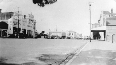
Photograph, Main Street Stawell looking East from St Georges Street with McClure's Garage, Post Office & the State Savings Bank on right 1930
Main Street Stawell McClure's garage Post Office State Savings Bank on Right. 1930 looking East from St Georges Streetstawell businesses streetscape -
 Stawell Historical Society Inc
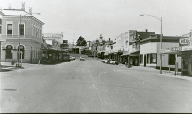
Photograph, Main Street Stawell looking East from west of Wimmera Street
Stawell Main Street looking East from west of Wimmera Street. Post office on left Post Office Arcade on right. Vehicles in distance.stawell streetscape -
 Clunes Museum
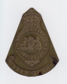
Ceremonial object - NUMISMATICS
MEDAL WORN BY F. J. EBERHARD AT MASONIC MEETINGSMASONIC BREAST JEWEL - ALL NATIONS LODGE NO.28 GOLD PLATED MOUNTED ON PALE BLUE RIBBON DISPLAYED IN ROYAL BLUE SILK LINED PRESENTATION CASEREVERSE OF SYMBOL - WOR. BRO. F.J. EBERHARD IN RECOGNITION OF HIS VALUABLE SERVICES AS SECRETARY - CLUNES 6TH DECEMBER.1927local history, societies, freemason, clunes lodge no.28, eberhard -
 Federation University Historical Collection
Article - Article - Metal plate, ZILLES COLLECTION: Metal Printers plate; T.W. Clark 205 Bourke Street Melbourne; Trade Mark
Zilles Printers was begun by Lewis Zilles in the early 1930s. It was in McKenzie Street Ballarat. His son Jeffrey also became a printer - letterpress, offset and screen printer. The business became Zilles Printers/Graphics and was in Armstrong Street and later Bell Street Ballarat. Metal plate made for T.W.Clark of 205 Bourke Street Melbourne. It is the Trade Mark stamp. Small brass coloured metal plate. Symbol and printing in reverse for stampingName of company - T.W. Clark 205 Bourke Street Melbourne written in circle with crown on top and kangaroo and emu in centre of circle. Scroll with Trade Mark at bottom of circle. Examples on various papers show stamp clearly.zilles, printers, ballarat, melbourne, t w clark, metal plate -
 Greensborough Historical Society
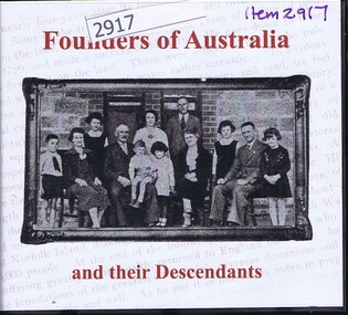
Audio - Compact disc, Founders of Australia and their descendants, 2007_
Book 1: discovery, exploration, settlement and economic development of Australia; Book 2: biographical details of early emigrants and pioneering familiesCompact disc in plastic case with printed, paper-insert coverFounders of Australia and their descendantsaustralian history, settlers, colonisation, european settlement, family history, pioneers -
 Ringwood and District Historical Society
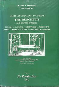
Book, Sir Ronald East, More Australian Pioneers - The Burchetts and Related Families, 1976
Hard cover book - Full title: A Family Who's Who Volume III - More Australian Pioneers - The Burchetts and Related Families - Phillips, Canning, Greenwood, Milbourne, Robin, Stroud, Straw, Whitworth & Wright. By Sir Ronald East, 1976."200 copies printed for private distribution in Memory of Our Pioneer Ancestors to ensure that they will not be forgotten. Copy Number 157. To Ann from Dad & Mum, date 25.12.76. -
 Kew Historical Society Inc
Photograph, Country Roads Board, Hays Paddock, East Kew, 1975
Colour photograph of Hays Paddock in East Kew taken by a Country Roads Board photographer. The reverse provides details of the negative and the purpose of the photograph.Reverse: "Hays Paddock. Tops of bank to be rounded gently, grassed & planted."hays paddock - kew east (vic), parks and gardens - kew (vic) -
 Greensborough Historical Society
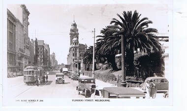
Postcard, Flinders Street Melbourne, 1930s
Flinders Street Melbourne, facing EastRose Series postcardBlack and white photograph, correspondence and address space on reverseRose Series P.206flinders street melbourne, melbourne -
Port Melbourne Historical & Preservation Society
Document - Booklet, Port Melbourne Historical and Preservation Society (PMHPS), The story of Sandridge, how the first settlers came to Port Melbourne. A history for children, c 1999
Sponsored by Holden and produced by Port Melbourne Historical and Preservation SocietyA history of Sandridge/Port Melbourne specifically aimed at children. Square buff coloured booklet with a black and white drawing of a rowing boat on the cover.Booklet is notated in red, dates and extra information.sandridge lagoon, garden city, piers and wharves - town pier, piers and wharves - railway pier, melbourne to hobson's bay railway, built environment, heritage, caroline frederica liardet, wilbraham frederick evelyn liardet, port melbourne yacht club, thomas swallow, william morley, david thomas, peter lalor, andrew plummer -
 Bendigo Military Museum
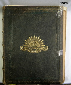
Book - BOOK, MEMORIAL, British-Australasian Publishing Service, The All-Australia Memorial, History, Heroes & Helpers, 1917
Walter Joseph Constantine Baldwin. Refer 1527.4. The book was an edition that came out during the war and had future updates with individual photos in the back. The volume listed all Victorians up until early 1916 who served.Black leather-looking cover with gold lettering and illustration of a rising sun with crown. Photo pasted on first page.Pasted inside front cover "BALDWIN, Walter JC No 1617 Dvr "C" Coy 38th Batt Transport Div 10th Brigade / Son of George and Elizabeth BALDWIN, 11th Street Mildura / Born at Yanac-a-Yanac July 20 1889 Educated Yanac-a-Yanac & Nichol's Point, Mildura SS Horticulturalist; enl Mildura Feb 1916. Emb June 1916. Service France, Belgium."books-history, military, all australian, baldwin, 38th bn -
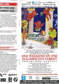 Melbourne Athenaeum Archives
Flyer/ brochure, The BZW Collins Street Grand Musical Promenade(music variety)by BZW Saturday 11 of November 1995
coloured brochures 750 outstanding musicians 130 extraordinary concerts 35 magical venues including: Melbourne town hall assembly hall athenauem theatre 1 athenauem theatre 2 Basement discs baptist church Cathedral room-ANZ Gothic Bank the melbourne club rauquet courts melbourne town hall council chambers miettas lounge gold vaults old treasury building 101 collins Street Scots Church 333 collins street capitol cinema city square kay croddocks antiquarian book shop gallery 101 melbourne town hall reception area mitre tavern novetel on collins micheals brasssere JJclark room 120 collins street reserve bank foyer the bzw colins street grand music promenade, athenaeum theatre one, the australian art orchestra, athenaeum theater two, the aspern papers, that, geoffrey tozer piano, roger woodward piano, nathan waks cello, stephen mcinytre piano, rita reichman piano -
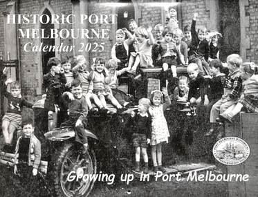 Port Melbourne Historical & Preservation Society
Document - Calendar 2025, Port Melbourne Historical & Preservation Society members, Historic Port Melbourne -Growing Up in Port Melbourne, October 2024
Researched, written and designed by PMHPS members.The cover of the 2025 "Historic Port Melbourne -Growing up in Port Melbourne " shows a group of children in 1957, on and in a car at the Presbyterian Church Kindergarten, Bridge Street Port Melbourne. The calendar was produced by members of the Port Melbourne Historical & Preservation Society and focuses on children's experiences growing up in Port Melbourne in the 1920's to the 1950's.education - kindergartens, education - primary schools, sport - football, sport - cricket, frank vincent, george langley, entertainment - celebrations -
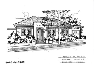 Hawthorn Historical Society
Drawing - Property Illustration, 1A Rosslyn Street, Hawthorn East, 1993
'After training as a Cartographic Draftsman within the mining industry, I worked as a property illustrator for real estate firms in the eastern suburbs of Melbourne for 23 years from 1983. I initially photographed houses with a Polaroid camera and made a 'thumbnail' sketch while there. The photos were used to scale off a sketch in pencil and then that sketch was overlaid with drafting film and the 'pen and ink' completed. The pens I used were the Rotring ‘Rapidigraph’ drafting pens. The ink was also made by Rotring (German).The film was ‘Rapidraw’, polyester drafting film, double matte. It takes a very fine line and doesn’t bleed. As well as house sketches, there were often floor plans and site plans ordered. Aerial sketches were ordered when the property needed an overall view.' (Margaret Picken, 2020)This property illustration is one of a series created by Margaret Picken for a range of real estate agents in Melbourne between c. 1983 and c. 2006. Each work is signed and dated by the artist.Gift of Margaret Picken, 2020pen and ink architectural drawing on drafting film.1A ROSSSLYN ST HAW EAST Margaret Picken ~91 WOODARDS - C'WELLartist - margaret picken 1950- -
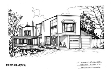 Hawthorn Historical Society
Drawing - Property Illustration, 3 Mowbray Street, Hawthorn East, 1993
'After training as a Cartographic Draftsman within the mining industry, I worked as a property illustrator for real estate firms in the eastern suburbs of Melbourne for 23 years from 1983. I initially photographed houses with a Polaroid camera and made a 'thumbnail' sketch while there. The photos were used to scale off a sketch in pencil and then that sketch was overlaid with drafting film and the 'pen and ink' completed. The pens I used were the Rotring ‘Rapidigraph’ drafting pens. The ink was also made by Rotring (German).The film was ‘Rapidraw’, polyester drafting film, double matte. It takes a very fine line and doesn’t bleed. As well as house sketches, there were often floor plans and site plans ordered. Aerial sketches were ordered when the property needed an overall view.' (Margaret Picken, 2020)This property illustration is one of a series created by Margaret Picken for a range of real estate agents in Melbourne between c. 1983 and c. 2006. Each work is signed and dated by the artist.Gift of Margaret Picken, 2020pen and ink architectural drawing on drafting film.3 MOWBRAY ST, HAW EAST Margaret Picken ~92 WOODARDS - HAWTHORNartist - margaret picken 1950- -
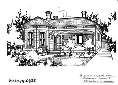 Hawthorn Historical Society
Drawing - Property Illustration, 4 Wills Street, Hawthorn East, 1993
'After training as a Cartographic Draftsman within the mining industry, I worked as a property illustrator for real estate firms in the eastern suburbs of Melbourne for 23 years from 1983. I initially photographed houses with a Polaroid camera and made a 'thumbnail' sketch while there. The photos were used to scale off a sketch in pencil and then that sketch was overlaid with drafting film and the 'pen and ink' completed. The pens I used were the Rotring ‘Rapidigraph’ drafting pens. The ink was also made by Rotring (German).The film was ‘Rapidraw’, polyester drafting film, double matte. It takes a very fine line and doesn’t bleed. As well as house sketches, there were often floor plans and site plans ordered. Aerial sketches were ordered when the property needed an overall view.' (Margaret Picken, 2020)This property illustration is one of a series created by Margaret Picken for a range of real estate agents in Melbourne between c. 1983 and c. 2006. Each work is signed and dated by the artist.Gift of Margaret Picken, 2020pen and ink architectural drawing on drafting film.4 WILLS ST HAW EAST Margaret Picken ~89 WOODARDS -HAWTHORNartist - margaret picken 1950- -
 Melbourne Tram Museum
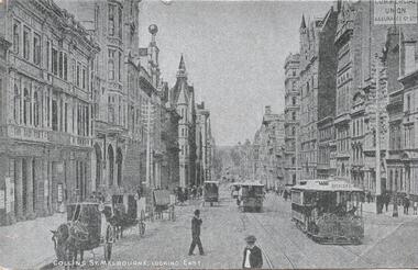
Postcard, "Collins St Melbourne looking East", 1900's
Postcard - silver finish known as "Collotype" - view of looking east along Collins St from near the intersection of Market St. Has a number of cable cars in the view, the first one having the destination of Spencer St. Has a number of horse drawn vehicles, parked or tethered on the wrong side of the road. Card titled "Collins St Melbourne looking East" Postcard has a divided back with space for stamp, address and correspondence. In the top centre is a start with an "O" in the centre. .1 - reproduction black and white photograph, collected by Keith Kings3392.1 - has "20c" in pencil in the top left hand corner and a TMSV Sales stamp on the rear.trams, tramways, cable trams, market st, collins st, buildings, horse drawn vehicle -
 Ballarat Heritage Services
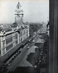
Photograph - Image, Flinders Street Railway Station, Melbourne, c1951
A black and white photograph of Flinders Street Railway Station in Melbourne.flinders street station, railway station, flinders street, melbourne, railway -
Ringwood and District Historical Society
Leaflets, Ringwood East Primary School, Ringwood East Primary School: In Touch magazine 1985, 1985
"In Touch" was printed weekly to inform pupils and parents of meetings, parent/teacher interviews and the general activities taking place in the school.5 leaflets called "In Touch" dated from 23-Apr-1985 to 4-Jun-1985 -
Port Melbourne Historical & Preservation Society
Booklet, Port Melbourne Football Club, Port Melbourne Football Club Year Book, 1968
Port Melbourne Football Club Year Book 1968. Red and blue strped coversport - australian rules football, port melbourne football club, pmfc -
 Department of Health and Human Services
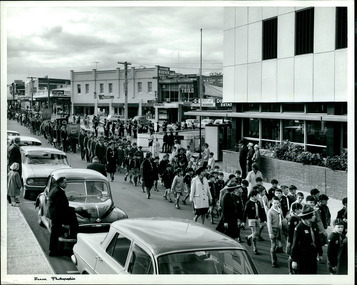
A street scene of Cub Scouts, school children and civilians attending a rally held in the City of Dandenong Circa 1960s, Melbourne, Australia - 2 of 2 photos - Department of Health – National Fitness Office (Sports & Recreation) – Historical Press Release Photo Collection
Department of Health – National Fitness Office (Sports & Recreation) – Historical Press Release Photo - Empire Youth Day & Royals on Tour CollectionDepartment of Health – National Fitness Office (Sports & Recreation) – Historical Press Release Photo - Empire Youth Day & Royals on Tour Collection -
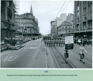 Department of Health and Human Services
Students from Saint Catherine’s School march past the Salute base on Swanston Street, Melbourne CBD Australia with the Premier Henry Bolte taking the salute - 1961 - Department of Health – National Fitness Office (Sports & Recreation) – Historical Press Release Photo Collection
Department of Health – National Fitness Office (Sports & Recreation) – Historical Press Release Photo - Empire Youth Day & Royals on Tour CollectionDepartment of Health – National Fitness Office (Sports & Recreation) – Historical Press Release Photo - Empire Youth Day & Royals on Tour Collection -
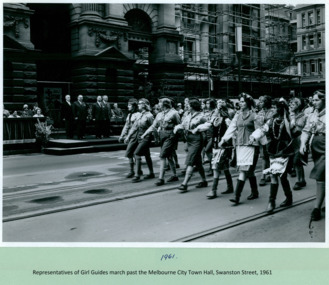 Department of Health and Human Services
Girl Guides, of differing ethnicities, march past the Premier Henry Bolte who is standing on the salute base on Swanston Street, Melbourne CBD Australia with the Premier Henry Bolte taking the salute - 1961 - Department of Health – National Fitness Office (Sports & Recreation) – Historical Press Release Photo Collection
Department of Health – National Fitness Office (Sports & Recreation) – Historical Press Release Photo - Empire Youth Day & Royals on Tour CollectionDepartment of Health – National Fitness Office (Sports & Recreation) – Historical Press Release Photo - Empire Youth Day & Royals on Tour Collection -
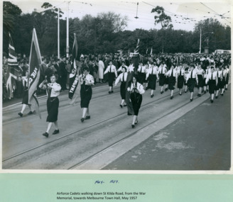 Department of Health and Human Services
Airforce Cadets, walking towards Swanston Street, from the War memorial on St Kilda Rd, Melbourne CBD Australia 1957 - Department of Health – National Fitness Office (Sports & Recreation) – Historical Press Release Photo Collection
Department of Health – National Fitness Office (Sports & Recreation) – Historical Press Release Photo - Empire Youth Day & Royals on Tour CollectionDepartment of Health – National Fitness Office (Sports & Recreation) – Historical Press Release Photo - Empire Youth Day & Royals on Tour Collection -
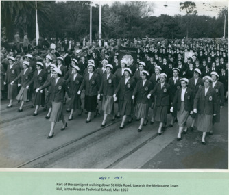 Department of Health and Human Services
A contingent of Preston Technical School, marching on St Kilda Road, from the War Memorial to Swanston Street, Melbourne CBD Australia 1957 - Department of Health – National Fitness Office (Sports & Recreation) – Historical Press Release Photo Collection
Department of Health – National Fitness Office (Sports & Recreation) – Historical Press Release Photo - Empire Youth Day & Royals on Tour CollectionDepartment of Health – National Fitness Office (Sports & Recreation) – Historical Press Release Photo - Empire Youth Day & Royals on Tour Collection -
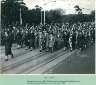 Department of Health and Human Services
Various representatives of Girl Guide groups marching on St Kilda Road, from the War Memorial to Swanston Street, Melbourne CBD Australia on May 1957 - Department of Health – National Fitness Office (Sports & Recreation) – Historical Press Release Photo Collection
Department of Health – National Fitness Office (Sports & Recreation) – Historical Press Release Photo - Empire Youth Day & Royals on Tour CollectionDepartment of Health – National Fitness Office (Sports & Recreation) – Historical Press Release Photo - Empire Youth Day & Royals on Tour Collection -
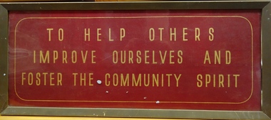 Kew Historical Society Inc
Plaque, East Kew Women's Club, To Help Others - Improve Ourselves And - Foster The Community Spirit, 1947
On Saturday 17 May 1947, an article on page 25 of the Australian Women’s Weekly reported on the formation of a new women's club: the East Kew Women’s Community Club. The article reads: "Wives and mothers in a Melbourne suburb, East Kew, have formed the East Kew Women's Community Club. While babies and young children are under the supervision of a play leader, wives and mothers follow up their own interests. The club caters for varying tastes, has musical appreciation, drama, and "Keep Fit" classes. President Mrs. Grace Thake says that the club hopes soon to have tennis, debating, and discussion groups. The club originated from a debate, "Should women take an active part in social and civic affairs?" Two days later their interest in these matters was proved by the forming of the club, which took for its motto: "To help others, improve ourselves, and foster the community spirit." Membership is open to all women, regardless of age, politics, and religion, and aims to co-operate with all societies working for the improvement of health and cultural standards." The article relates particularly to the plaque in the collection of the Kew Historical Society.The East Kew Women's Community Club, also called the East Kew Women's Community Club functioned from c. 1947 to the end of the 1960s (to be verified). The records of the Club were placed with Kew Historical Society to preserve them for posterity. The records and objects belonging to the East Kew Women's Community Club have significance socially for their capacity to illuminate women's associations in the post war period in Australia.Framed red and gold enamelled plaque belonging to the East Kew Women's Community Club."TO HELP OTHERS / IMPROVE OURSELVES AND / FOSTER THE COMMUNITY SPIRIT"east kew women's social club, community groups -- kew east (vic.) -
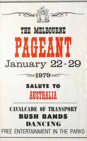 Melbourne Tram Museum
Poster, Victorian Government, "The Melbourne Pageant - January 22 - 29 1979 - Salute to Australia, Cavalcade of Transport", 1979
Poster - special size sheet, titled "The Melbourne Pageant - January 22 - 29 1979 - Salute to Australia, Cavalcade of Transport" advertising the planned events and dates with a map. Two copies held.trams, tramways, australia day, mmtb, melbourne, tramcars, pageant, melbourne pageant -
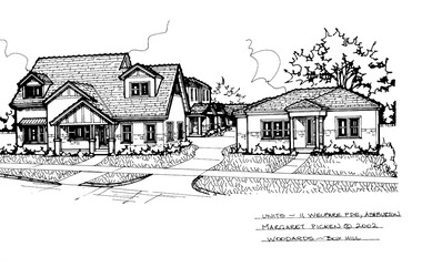 Camberwell Historical Society
Drawing (series) - Architectural drawing, 11 Welfare Parade, Ashburton, 2002
artist, architectural drawings, margaret picken, camberwell, housesartist, architectural drawings, margaret picken, camberwell, houses -
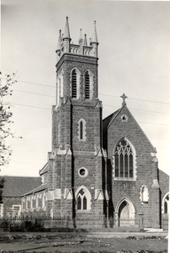 Federation University Historical Collection
Photograph - Photograph (black & White), St Alipius Catholic Church, Ballarat East
St Alipius Church is often associated with the Eureka Stockade in 1854. The priest of that era, Father Patrick Smythe, attempted to maintain peace among his parishioners, and was present at the amputation of Peter Lalor's arm. Henry Richards Caselli was the supervising Architect of St Alipius', Victoria Street, Ballarat East.Black and white photograph of a bluestone church. St Alipius Catholic Church is located in Victoria Street, Ballarat East.st alipius, church, catholic, ballarat east, eureka stockade, henry richards caselli -
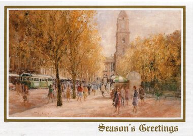 Melbourne Tram Museum
Drawing - Illustration, Australian Rotary Health Research Fund, "Swanston Street Melbourne", late 1980s
Illustration - colour engraving printed onto white card, titled "Swanston Street Melbourne" of a painting of a street scene in Swanston, looking north with the Town Hall and the City Square in the work. Painting by John Tiplady, produced to raise funds for the Australian Rotary Health Research Fund. Used for a Christmas Card.trams, tramways, swanston st, town hall, greetings cards