Showing 1526 items
matching aerial photograph
-
 Bendigo Military Museum
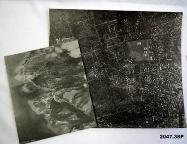
Photograph - AERIAL PHOTOGRAPHS WW2, 1942 - 1944
... 37 Aerial reconnaissance photographs of various locations.... photography-photographs-military Aerial Most images: Locations ...Various reconnaissance photographs depicting targets in Timor for attack by the R.A.A.F. Items saved by Maurice Anthony BYRNE RAAF. Refer Cat No 215.9 for his service details.37 Aerial reconnaissance photographs of various locations over Timor and surrounding islands 1 Envelope: original container of photographs.Most images: Locations, including Latitude and Longitude marked on the backphotography-photographs-military, aerial -
 Linton and District Historical Society Inc
Photograph, Photographer: Alan Giles, Aerial View of Linton, 1991, 1.9.1991
... Colour photograph, aerial view of Linton township looking..., Vic-1st September 1991". Colour photograph, aerial view ...Photograph taken by Alan Giles whilst on a joy flight over Linton. Shows oval, left top corner, Sussex St (Glenelg Highway) running from bottom RH corner.Colour photograph, aerial view of Linton township looking north."Linton township, Vic-1st September 1991".linton township -
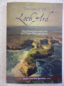 Warrnambool and District Historical Society Inc.
Book, The Lost of the Loch Ard, 2015
... Soft card cover with coloured aerial photograph of Loch Ard... with coloured aerial photograph of Loch Ard Gorge Title in brown ...The Loch Ard had left England in March 1878 and 90 days later on June 1st it was approaching the coast of Victoria when it wrecked off the coast near Port Campbell at what was to become known as Loch Ard Gorge. Two people survived, Eva Carmichael and Tom Pearce. While much has been recorded about the survivors, this is the first publication which looks at the other 51 people on board. This book lists where they came from, family histories and lists internet references for further information. Some of the names listed are Yates, Stuckey, Jones, Rolleston, Godby, Mitchell, Fax, Hunt and Giles.An interesting insight into an aspect of the Wreck of the Loch Ard which has been previously unknown. Written by local authors.Soft card cover with coloured aerial photograph of Loch Ard Gorge Title in brown with sub title in white. Authors name in white on brown strip at bottom of cover. The back cover has blurb written in panel imposed over photo of Loch Ard Gorge looking seaward. 160 pages.Authors Carlyn and Ron Sproston.warrnambool, loch ard, lost of the loch ard, loch ard gorge, -
 Port Melbourne Historical & Preservation Society
Photograph - Aerial view of 3 liners at Station Pier, Port Melbourne, 14 Feb 2001
... Large colour aerial photograph of 3 liners at Station Pier... & Ariell Ltd Band Rotunda Large colour aerial photograph of 3 ...Large colour aerial photograph of 3 liners at Station Pier. Siver Cloud - outer East; QE2 - outer West; Regal Princess - inner West. View of Port Melbourne housing and foreshore development. Women's Welcome (or band) Rotunda on left of photo. Also a newspaper copy of the photo. COPYRIGHT RESTRICTEDmaritime, piers and wharves - station pier, transport - shipping, queen elizabeth ii, regal princess, silver cloud, beacon cove, swallow & ariell ltd, band rotunda -
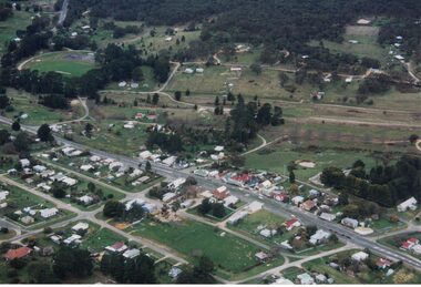
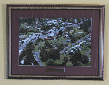
 South Gippsland Shire Council
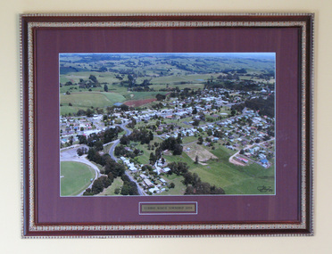
Photograph, Framed, Aerial Scene of Mirboo North, 2004
... : "Mirboo North Township 2004". Features an aerial photograph...: "Mirboo North Township 2004". Features an aerial photograph ...One of a set of two. Framed colour photograph titled: "Mirboo North Township 2004". Features an aerial photograph of the township of Mirboo North. Set in maroon card window mount and decorative brown and gold wood frame. Engraved brass text panel with white lined border affixed below image. -
 South Gippsland Shire Council
Photograph, Framed, Aerial town view of Mirboo North, 2004
... : "Mirboo North Township 2004". Features an aerial photograph...: "Mirboo North Township 2004". Features an aerial photograph ...One of a set of two. Framed colour photograph titled: "Mirboo North Township 2004". Features an aerial photograph of the township of Mirboo North. Set in maroon card window mount and decorative brown and gold wood frame. Engraved brass text panel with white lined border affixed below image. -
 Ballarat Tramway Museum
Photograph - Black & White Photograph/s, late 1960's
... Black and white aerial photograph of the central area... and white aerial photograph of the central area of Ballarat ranging ...Black and white aerial photograph of the central area of Ballarat ranging from Mair St to Mt Pleasant, Drummond St and Victoria St. Taken late 1960's as it would appear that the construction of Sovereign Hill has commenced. Shows the tram tracks and possibly parking areas being marked out. On rear in pencil "2384/90"trams, tramways, ballarat, aerial views, sovereign hill -
City of Kingston
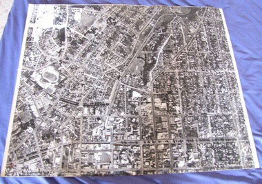
Photograph - Black and white, 20 December 1945
... Aerial photograph of the Cheltenham area in the City... a commercial zone. This aerial photograph provides evidence ...This aerial image covers a section of Cheltenham, with a large paddock yet to be converted to an industrial and later a commercial zone.This aerial photograph provides evidence of the changing landscape of Cheltenham and Highett since WWII. Photographed in 1945, the image features a large block of land now the site of site the major transformation of Cheltenham with the development of the Southland shopping centre in the 1960s and expansion in the 1990s.Aerial photograph of the Cheltenham area in the City of Kingston. This 1945 image is concentrated on the area between Bay Road and Garfield Lane with the distinctive bend into Jean Street. A large block of land runs between the Nepean Highway and the rail line. This is now the area occupied by the extension of Southland in the 1990s. It is a negative version of VKHC124.cheltenham, southland, market garden -
South Gippsland Shire Council
Photograph, Framed, Aerial Scene of Mirboo North, 2004
... : "Mirboo North Township 2004". Features an aerial photograph...: "Mirboo North Township 2004". Features an aerial photograph ...One of a set of two. Framed colour photograph titled: "Mirboo North Township 2004". Features an aerial photograph of the township of Mirboo North. Set in maroon card window mount and decorative brown and gold wood frame. Engraved brass text panel with white lined border affixed below image. -
 Ballarat Tramway Museum
Photograph - Colour Photograph/s, Paul Mong, 29/03/2002 12:00:00 AM
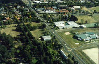
... Aerial photograph of the South Gardens Reserve... Depot Aerial photograph of the South Gardens Reserve ...Aerial photograph of the South Gardens Reserve and the Ballarat High School grounds showing the Ballarat Tramway Depot, Fish Hatchery and associated area from the north east aspect. Taken by Paul Mong 29 March 2002. On Fujicolor Crystal Archive Paper. Height of about 1000ft or 330m above ground level.btm, south gardens reserve, btm depot -
Bendigo Historical Society Inc.
Photograph - ELMORE FIELD DAYS
... Aerial photograph of Elmore Field Days site. Undated... Agriculture elmore field days Aerial photograph of Elmore Field Days ...Elmore Field Days were first held in 1964.Aerial photograph of Elmore Field Days site. Undated but possibly 1969-1970. Image shows exhibitor stands, roadways and parked vehicles. Oh LH side of image is a water course, an anabranch of the Campaspe River. Site is now a camping reserve as the Elmore Field Days is now (2022) held at a nearby site.event, agriculture, elmore field days -
 Warrnambool and District Historical Society Inc.
Documents, Late 20th, early 21st centuries
... This is a 2006 coloured aerial photograph of the Lake Pertobe area... This is a 2006 coloured aerial photograph of the Lake Pertobe area ...These ten documents (maps, plans, photographs) mostly come from the Warrnambool City Council and most contain information on sub-divisions and titles of properties in areas around the Central Business District of Warrnambool. The dates range from 1986 to 2006. These maps, plans and photographs are of some interest as they give historical details of subdivisions in Warrnambool and date from the late 20th century. .1 This is a laminated map of the boundaries of Local Governments in Victoria. It is Sheet I of 2 and has red and blue pencil markings and black boundary markings. .2 This is a copy of a plan of a survey in black and white markings on paper. .3 This is a plan of the title details of Section 19 Warrnambool. It has black printing on buff-coloured paper. .4 This is a plan of the allotments in part of the Central Business District of Warrnambool. It is printed in black and white. .5 This is a 2006 coloured aerial photograph of the harbour at Warrnambool – Breakwater etc. .6 This is a 2006 coloured aerial photograph of the Lake Pertobe area in Warrnambool .7 This is a coloured aerial photograph of Warrnambool’s streets over-stamped with road numbers in large blockings. .8 This is a plan showing the title details of Section 11 in Warrnambool. It has black printing on buff-coloured paper. .9.1 This is a plan of sub-divisions in parts of Crown Allotments 38 & 39 in Warrnambool. It has green, pink and yellow markings with black printing. .9.2 This is a plan of the sub-divisions in parts of Allotments 38 & 39 in Warrnambool. It has pink, yellow and blue markings with black printing. It is somewhat faded. warrnambool c.b.d. maps and plans, history of warrnambool -
 Warrnambool and District Historical Society Inc.
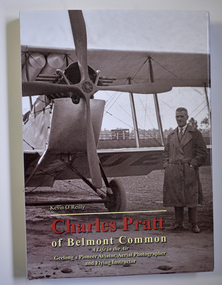
Book - Biography of Charles Pratt, Kevin O'Reilly, Charles Pratt of Belmont Common, 2016
... the Warrnambool region, taking aerial photographs, with this important..., taking aerial photographs, with this important collection ...Biographical material of Charles Pratt and diary extractsThis is a book of 280 pages with a blue and brown hard cover with sepia -coloured photographs on the front and back covers and multi-coloured print on the cover and spine. The dust cover has the same content as the hard cover. The pages contain printed text, black and white photographs, charts and sketches. non-fictionBiographical material of Charles Pratt and diary extracts charles pratt, 1920s aerial photographs, warrnambool history -
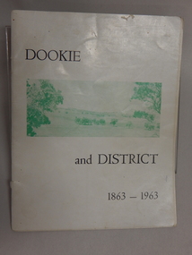 Dookie Historical Society
Soft Cover Dookie District History Book - Width 18.5cm x Height 24cm Consist of 33 pages (not numbered), The General Committee Organising the Dookie Back To, Dookie and District 1863 - 1963, Easter 1963 "WATERWHEEL PRESS,"
... and white soft aerial photographs of prominent landmarks at Dookie... and white soft aerial photographs of prominent landmarks at Dookie ...Soft Cover Historical Book - White Background with 2 green and white soft aerial photographs of prominent landmarks at Dookie. Front Cover - Mount Major on the left and Saddleback on the right. Back Cover - An aerial view of Dookie as it is today, showing the Grain Elevators Board wheat silos under construction (lower right foreground). -
 City of Kingston
Photograph - Black and white, c. 1970
... Black and white aerial photograph featuring the Highett Gas... adhesives Black and white aerial photograph featuring the Highett ...The Highett Gas Works were a landmark along the Nepean Highway for many years. With the cessation of the gasification of coal and the introduction of natural gas to Victoria, the gas holders were demolished and the Sir William Fry Reserve was developed on the southern end of the site. The Gas and Fuel redeveloped the northern end of the site with modern offices and laboratories for the organisation's scientific services. At this time, the chimney and retort house were retained.The Highett Gasworks had its beginning in 1939 operated by the Central Brighton and Moorabbin Gas Co Ltd. The company had expanded its gas production facilities to Highett where it had purchased 45 acres of land adjacent to the Melbourne-Frankston railway line. The first gasholder was erected on the Highett site in 1927 and connected with high pressure mains to the Brighton Gas Works. In 1939 the building program including gasometers, the vertical retort house and coal store was completed and gas making commenced. Its area of supply covered approximately 70 square miles and included the municipalities of Brighton, Sandringham, Moorabbin, Mordialloc, Chelsea and part of Dandenong. The Gas and Fuel Corporation eventually took over operations and with the disaggregation and privatisation of the organisation, the site was eventually closed c. 2002.Black and white aerial photograph featuring the Highett Gas Works with gasholders and retort house. In the top right-hand corner, a former Highett Primary School on Graham Road can be viewed. Photograph includes Bay Road, Royal Avenue, Princess Avenue and Jackson Road (Highett) and Alfred, Turner and Sandford Streets (Moorabbin).Handwritten in black ink: [indecipherable] in a circle Handwritten in red ink: 70% Four velcro display adhesivesgasification of coal, gas and fuel corporation of victoria, gasholders, highett, moorabbin, utilities -
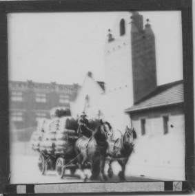 Mission to Seafarers Victoria
Slide - Glass slide, Black and white, Mission to seamen building, Flinders St and loaded horse-drawn wagon, circa 1920s
... on an aerial photograph of the area dated 1927.... on an aerial photograph of the area dated 1927. This image besides ...This Spanish Mission style building first opened in 1917 and has been in continual use since as the Mission to seamen and later Mission to Seafarers at a location initially known as the extension to Flinders St near the Australian Wharf and later address known as 717 Flinders St. "The Extension Bond and Free stores" building which can be seen in the background can be identified on an aerial photograph of the area dated 1927.This image besides showing an early view of the current Mission to Seafarers building also features a glimpse of the early 20th C (Flinders St) Extension Bond ( Store ?) building positioned to make use of the Yarra-side docks known as the Australian Wharf.Positive photograph on medium format glass slide ; b & w image of the chapel and bell tower of 1917 Mission Building, extension to Flinders St. with a loaded horse-drawn dray or wagon being driven in the foreground. . In the background of image can be seen a section of a large warehouse or Bond store building, visible signage reads: "Extension Bond"in upper case letters. The foreground details appear to have been hand touched up with linear ink highlights. Image is slightly blurry. The slide is edged with adhesive tape.pencil cross at lower right corner on adhesive tape edgingmissions to seamen institute, mission building, extension bond store, warehouse -
Lakes Entrance Historical Society
Photograph - Framed photograph, 2002c
... Mounted photograph, aerial view of waterway and housing... Mounted photograph, aerial view of waterway and housing area from ...Mounted on chipboard, rear of backboard has strap for wall hangingMounted photograph, aerial view of waterway and housing area from Kalimnaphotography, photographs, slides, film -
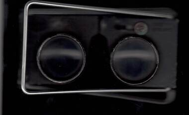
Frankston RSL Sub Branch
Magnifier, Map Reading
... detail when reading maps or examining aerial photographs complete... aerial photographs complete with a leather storage pouch ...A small pocket size folding magnifier used for enlarging detail when reading maps or examining aerial photographs complete with a leather storage pouch. Manufactured of brass by Casartelli of Manchester, England. When unfolded this forms a "U" shape with the glass lens positioned conveniently for map viewing and the base can be used to measure scaled distances.This item is stamped "CASARTELLI, MANCHESTER" and has 1/4, 1/2 and 1 inch markings. -
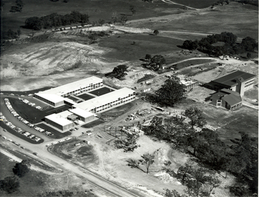 Federation University Historical Collection
Photograph - Black and White, N. L. Harvey, Aerial Views of Mount Helen Campus, 1973, 1973
... Three aerial photographs of the Mount Helen Stage 2... mount helen construction stage 2 Three aerial photographs ...The Stage 2 buildings at the Federation University Mount Helen Campus were underway in 1973.Three aerial photographs of the Mount Helen Stage 2 building activities * Westward view of Stage 2 buildings under construction, Aug 1973 * View to the South West showing Stage 2 buildings under construction, Aug 1973 * View to the North West showing Stage 2 buildings under construction, Aug 1973federation university, federation university australia, feduni, university of ballarat, ballarat townscape, mount helen, construction, stage 2 -
Port Melbourne Historical & Preservation Society
Photograph - Aerial view of Port Melbourne, 23 Dec 1945
... One of three prints of aerial photographs of Port Melbourne... of aerial photographs of Port Melbourne 23.12.1945, showing ...One of three prints of aerial photographs of Port Melbourne 23.12.1945, showing different areas and to different scales: this one vertical, takes in Station and Town Piers, railyards, Missions to Seamen, Engine Works, temporary US wartime structures, edge of COR buildings, Swallow & Ariell, portion of Wiilliamstown Road. (Smaller copies located in A.06.04.B4)piers and wharves - station pier, piers and wharves - town pier, war - world war ii, built environment, transport - railways, missions to seamen, swallow & ariell ltd -
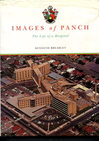 Alfred Hospital Nurses League - Nursing Archive
Book - Illustrated book, Kenneth Brearley, Images of PANCH - the life of a hospital, 1999
... is an aerial photograph of PANCH. On the back cover is the hospital's... and author's name on front and spine. Also on front is an aerial ...A history of the Preston and Northcote Community Hospital, from the initial proposal in 1941 that a hospital be built in Preston, the official opening of the hospital in 1960, until it's closure in1998Illustrated book with dust jacket. Hardcover is bound in red with gilt printing on front (Images of PANCH) and spine (full title and author's name). Dustjacket has a white background, title and author's name on front and spine. Also on front is an aerial photograph of PANCH. On the back cover is the hospital's coat of arms and the words 'Preston and Northcote Community Hospital'non-fictionA history of the Preston and Northcote Community Hospital, from the initial proposal in 1941 that a hospital be built in Preston, the official opening of the hospital in 1960, until it's closure in1998preston and northcote community hospital, hospitals-victoria-history, preaton, panch -
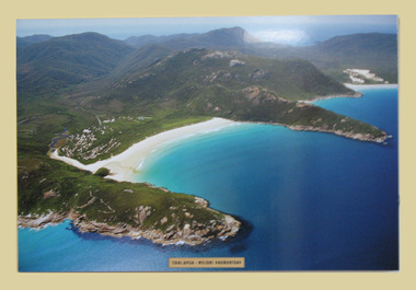 South Gippsland Shire Council
Photograph, Mounted, Tidal River Wilson's Promontory, 2003
... Aerial colour photograph titled "Tidal River Wilson's... gippsland Aerial colour photograph titled "Tidal River Wilson's ...Aerial colour photograph titled "Tidal River Wilson's Promontory. Laminated and block mounted on foamcore board. Text panel lower edge. -
 City of Kingston
Photograph - Black and white, 20 December 1945
... Aerial photograph taken in 1945 of the Cheltenham district... Black type 10200 FTS 30' LENS 20.12.45 Aerial photograph taken ...Cheltenham is a suburb in the City of Kingston that was originally established as a rural market gardening community. The area is bordered by Highett, Mentone and Heatherton. The market gardens, farms and paddocks have gradually been sub-divided into housing and industrial estates. The Southland shopping centre is a major feature of the area.Cheltenham was established as a rural market gardening community. The Le Page family lived in Cheltenham since 1854 when Nicholas Le Page, a tailor from the Channel Island of Guernsey, bought two acres of land on Chesterville Road near Bernard Street to establish a market garden. Over the years the Le Pages purchased more land in the area. In 1875-76 Nicholas' son Frank and his wife Mary built 'Daphne Cottage' near the corner of Bernard and Wilson Streets. n the 1940s Frank's son, Everest Le Page, bought five more lots of land in Chesterville Road from the Tuck family. The Le Pages grazed horses, ponies and cows on this land, and grew pumpkins, carrots, parsnips, onions, potatoes and cabbages. Many buildings and locations within in Cheltenham commemorate the Le Page family's contribution to the Cheltenham community.Aerial photograph taken in 1945 of the Cheltenham district within the City of Kingston. The image includes Chesterville Road, the future site of Turner Road pool (now Waves) and Highett Reserve, (top left), Jellicoe Street, Argus Street, Bernard Street, Wilson Street, the Methodist Children Homes (now Southland), McIvor Street, Goulburn Street, Nepean Highway, Jamieson Street and Barker Street (bottom left), market gardens and paddocks. In the top centre of the image, "Daphne Cottage", the home of Frank T. Le Page is visible on the corner of Bernard and Wilson Streets. Much of the land depicted in this image was owned by the Le Page family. This image is possibly from the collection of aerial photographs commissioned by the Department of Crown Lands and Survey and taken by Adastra Airways.Black and white ink: 57250 White print: VIC-170 57250 20.12.45 Run 6 PROJ. No. 5 MELB. METROP AREA Black type 10200 FTS 30' LENS 20.12.45cheltenham, market gardens, industry, le page family -
 Warrnambool and District Historical Society Inc.
Book, Warrnambool Botanic Garden Masterplan, February 1995
... with plastic rings, the front cover is plasticized with an aerial... with plastic rings, the front cover is plasticized with an aerial ...This Warrnambool Botanic Gardens Study and Report was funded by the National Estate Grants Program of the Australian Heritage Commission and the City of Warrnambool. It was monitored in progress by a Steering Committee consisting of representatives of the Botanic and Public Gardens Advisory Committee, the Warrnambool City Council, Friends of the Warrnambool Botanic Gardens and National Estate Grants Program representatives and community representatives. The Warrnambool Botanic Gardens were first sited close to the Hopkins River in 1859. In 1869 the gardens were relocated to the present day location in Botanic Road. This plan is of some importance as it gives an overview of the history and current condition in 1995 of the Warrnambool Botanic Gardens and draws up a plan for its future development. It is useful for research and for consideration by the City Council today of policy making and further development of the gardens. This is a publication containing a master plan for the Warrnambool Botanic Gardens. It has a section on acknowledgements, a summary, eight chapters, and 14 appendices. The pages are bound with plastic rings, the front cover is plasticized with an aerial photograph of the Botanic Gardens and surrounds and the back cover is lightweight cardboard. The pages contain printed material, fold out maps, sketches and diagrams and many photocopied photographs.Front Cover: City of Warrnambool, Warrnambool Botanic Gardens, Conservation and Development Plan, Jill Orr-Young, Patrick Mallon, SF Consultants Pty Ltd, February 1995. warrnambool botanic gardens, warrnambool -
 Bendigo Historical Society Inc.
Photograph - 1.25,000 BENDIGO AERIAL PHOTOGRAPHS
... Eighteen undated coloured 1.25,000 army aerial photographs... coloured 1.25,000 army aerial photographs covering Bendigo city ...Eighteen undated coloured 1.25,000 army aerial photographs covering Bendigo city and district. [a] -( Similar to A vintage Abrams map reader -Adjustable Stereoscope) -Casella London viewing eye frame with Irving scratched into frame. Another name scratched out also. [b] WW2 Leather pouch stamped Casella London made to hold eye frame.bendigo, utilities, fortuna army mapping division -
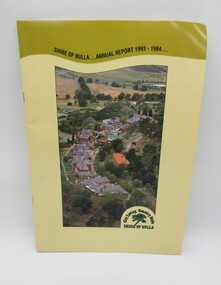 Hume City Civic Collection
Annual Report, Shire of Bulla: Annual Report, 1993 - 1994
... has an aerial photograph which features the former Sunbury... an aerial photograph which features the former Sunbury Asylum ...The 1993 - 1994 Annual Report was published by the Shire of Bulla and distributed to the residents of the shire.A 24 paged publication with a yellow cardboard cover which has an aerial photograph which features the former Sunbury Asylum buildings and surroundings before the area was developed for housing. The former Shire of Bulla logo which featured 'City Living - Country Style' is in the bottom RH corner of the photograph. Details of the administration officxes of the Shire of Bulla are printed on the back cover.shire of bulla, annual reports, councillors, george evans collection -
![Plan, University of Melbourne Burnley Campus Institute of Land and Food Resources Formerly known as the Royal Horticultural Gardens Burnley [sic], 2001](/media/collectors/52f2d90c9821f4163875a333/items/6145823c174069677c22f6e6/item-media/65ef8feeb2201fddf6999498/item-fit-380x285.jpg) University of Melbourne, Burnley Campus Archives
University of Melbourne, Burnley Campus ArchivesPlan, University of Melbourne Burnley Campus Institute of Land and Food Resources Formerly known as the Royal Horticultural Gardens Burnley [sic], 2001
... and black and white aerial photographs from which the plan was made. .... Plan with trees and plants. Colour and black and white aerial ...site plan, buildings, planrs -
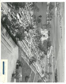 Bendigo Historical Society Inc.
Photograph - ELMORE FIELD DAYS 1970
... Black and white aerial photograph of Elmore Field Days site... Agriculture elmore field days Black and white aerial photograph ...Elmore Field Days were first held in 1964.Black and white aerial photograph of Elmore Field Days site. Lines of exhibitors and vehicles on site. Anabranch of Campaspe River alongside site. On back of photo :' Robert Wallace Studios, 8 Ruth Street, Golden Square' Elmore Field Days site has been moved to purpose built site nearbye. The site pictured is now a camping reserve.event, agriculture, elmore field days -
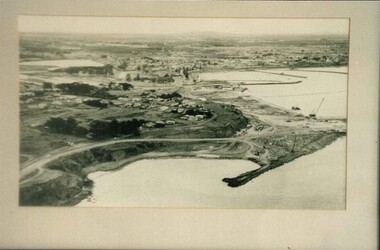 Glenelg Shire Council Cultural Collection
Photograph, (untitled), 1954
... BxW photograph. Aerial view of develpoment of Port...: (no inscriptions) Back: 1954 BxW photograph. Aerial view of develpoment ...Port of Portland Authority archives.Front: (no inscriptions) Back: 1954port of portland archives