Showing 8329 items matching "bridging"
-
 Charlton Golden Grains Museum Inc
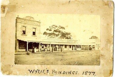
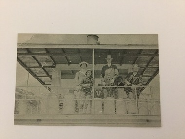
Photograph, Wylie's Buildings 1877, c. 1877
Earliest known photo of the stores. Johnson's Bridge store built 1873. Procter's c. 1876. Western end, left hand side of High Street, Charlton. Earliest known photo of the storesPhotograph of Peter Johnson's Bridge Store High St Charlton. Titled Wylie's Buildings 1877. Group of people on footpath. Peter Johnson's store, Reed Chemist shop, Procter's Butcher shop, Bank of New South WalesWylie's Buildings 1977peter johnson a.d. 1877 general storekeeper, peter johnson, draper, iron monger, timber merchant, general produce, jas reed, druggist, butcher, r procter & son, business, industry -
 Glenelg Shire Council Cultural Collection
Photograph - Photograph - Road and bridge, n.d
Sourced from Casterton Town Hall (former Shire of Glenelg)Coloured photograph. Unsealed road between two paddocks. Wooden bridge and railings. Sign at bridge ' Bridge Load Limit 5t gross' -
 Stawell Historical Society Inc
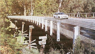
Photograph, Delley's Bridge Halls Gap
White vehicle crossing Delley's Bridge Halls Gap c 2000. This Bridge has been replaced at Halls Gap with a new bridgetransport, bridge -
 Orbost & District Historical Society
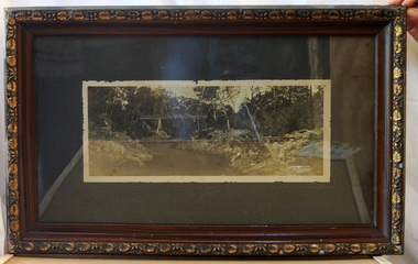
framed black and white photograph, C1920
Boggy Creek Bridge was built in 1916 as part of the Bairnsdale to Orbost extension to the main Gippsland Railway, and is situated in the middle of the township of Nowa Nowa, crossing a steep-sided and well-timbered creek-valley. This section of the line closed in 1987. This item is a pictorial record of the Boggy Creek railway bridge on the East Gippsland line. This bridge plays a major part in the identity and history of the town of Nowa Nowa, since Boggy Creek’s steep sided valley divides the township into two components.A black / white photograph of a bridge across a river in the bush. It is under glass in a brown wooden frame which has gold decorated edges. There appears to be a man sitting on rocks in the right front foreground.on front of photograph - "Nowa Nowa Creek, Gippsland, Victoria, Sears, Copyright"boggy-creek-nowa-nowa east-gippsland-railway bridge-rail -
 Stawell Historical Society Inc
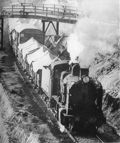
Photograph, K Class 157 Steam Engine pulling freight
K Class 157 Steam Train Engine pulling freight in cutting under Colquhuon Street bridge. Photo was taken from Hill Street Stawell around c 1962. Copy from original photograph of "K" Class 157 Steam engine pulling freight trucks going up the cutting and under the Colquhuon St. bridge. The rail line runs parallel to Napier St. c 1962. K 157.railways -
 Lakes Entrance Historical Society
Photograph - North Arm Bridge, road to Bullock Island, build up of sand spit later site for Fishing Club and boat ramp, Lakes Entrance Victoria, G W Holding, 1/04/1979 12:00:00 AM
North Arm Bridge, road to Bullock Island, build up of sand spit later site for Fishing Club and boat ramp, Lakes Entrance Victoria. Taken during the King of the Straits eventColour photograph taken from Kalimna Heights showing North Arm Bridge, road to Bullock Island, build up of sand spit later site for Fishing Club and boat ramp, Lakes Entrance Victoria waterways, islands, bridges -
 Lakes Entrance Historical Society
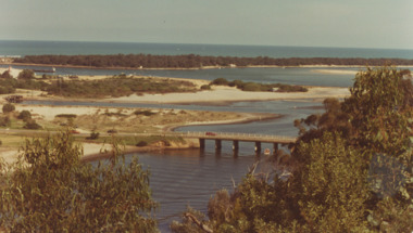
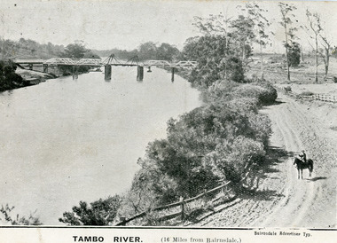
Postcard - Bridges, 1906
First timber road bridge over the Tambo River at Swan Reach officially opened 20 December 1905, after which punt was removed to BairnsdaleBlack and white postcard of the lifting bridge over the Tambo River at Swan Reach, Victoria. Man on horse standing on dirt road to Metung beside the river. Punt previously used to cross river visible against western bank of river.Tambo River (16 miles from Bairnsdale)bridges, waterways -
 Hume City Civic Collection
Photograph, 1980s
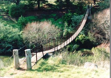
The timber and cable swing bridge straddled the Deep Creek at Bulla behind the Bulla school. It enabled children who lived across the river to travel directly to school instead of going the long way around the road, a possible distance of 2-3 kms.A coloured photograph of the timber and cable swing bridge which was constructed across the Deep Creek at Bulla. Trees are growing along the river bank and there is a row of conifers growing along the opposite bank.swing bridges, deep creek, george evans collection -
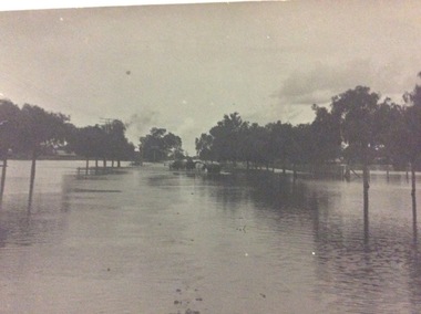
 Orbost & District Historical Society
black and white photograph, February 1971
This photograph was taken near the Snowy River Bridge on the the old Princes Highway in Orbost, near the caravan park. The 1971 flood was the the worst flood on record. At Jarrahmond it was at least 11 metres and up to one and a half kilometres wide on the flats causing enormous damage to the flood plain. Records say that "The brown floodwater stain in Bass Strait could be seen from passing airliners." Considerable damage was done to railway infrastructure, roads and farms. More information from the APRIL, 2008 newsletter by John Phillips. (see orbosthistory.com.au)This is pictorial evidence of a significant local event. Floods have been an integral part of Orbost's history for hundreds of years.A black / white photograph of debris, fallen power lines, a tree across the highway and floodwaters across the road.on front at bottom - handwritten in upper case print - " 1971 FLOOD PRINCES HIGHWAY NEAR SNOWY BRIDGE"floods-orbost-1971 -
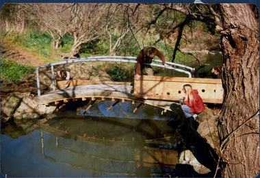
 Darebin Parklands Association
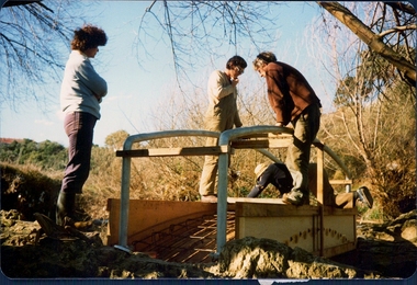
Installing Clifton Bridge, 1979-1980
The bridge was designed and constucted by Sidney Clifton, an engineer who lived in a house neighbouring the parklands.Colour photograph. Four people installing the wooden frame used to set the concrete section of Clifton Bridge. This item and all other Darebin Parklands Association archival material is now held by State Library Victoria (Accession No: YMS 13746). Please contact State Library Victoria if access is required. -
 Darebin Parklands Association
Installing Clifton Bridge, 1979-1980
The bridge was designed and constucted by Sidney Clifton, an engineer who lived in a house neighbouring the parklands.Colour photograph. Four men installing the wooden frame used to set the concrete section of Clifton Bridge. This item and all other Darebin Parklands Association archival material is now held by State Library Victoria (Accession No: YMS 13746). Please contact State Library Victoria if access is required. -
 Darebin Parklands Association
Installing Clifton Bridge, 1979-1980
The bridge was designed and constucted by Sidney Clifton, an engineer who lived in a house neighbouring the parklands.Colour photograph. Three men installing the wooden frame used to set the concrete section of Clifton Bridge. This item and all other Darebin Parklands Association archival material is now held by State Library Victoria (Accession No: YMS 13746). Please contact State Library Victoria if access is required. -
 Darebin Parklands Association
Installing Clifton Bridge, 1979-1980
The bridge was designed and constucted by Sidney Clifton, an engineer who lived in a house neighbouring the parklands.Colour photograph. Four people installing the wooden frame used to set the concrete section of Clifton Bridge. This item and all other Darebin Parklands Association archival material is now held by State Library Victoria (Accession No: YMS 13746). Please contact State Library Victoria if access is required. -
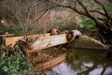
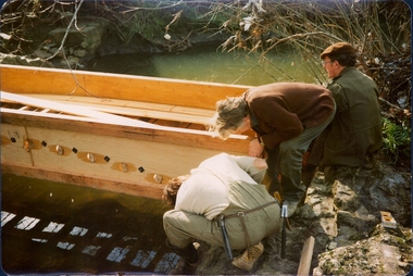
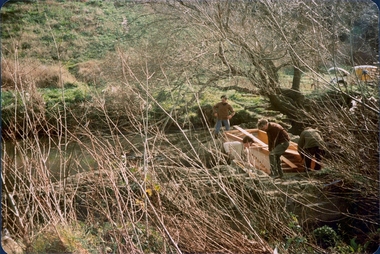
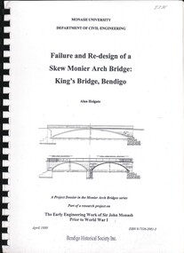 Bendigo Historical Society Inc.
Book - FAILURE AND RE-DESIGN OF A SKEW MONIER ARCH BRIDGE: KING'S BRIDGE, BENDIGO, April 1999
Failure and Re-Design of a Skew Monier Arch Bridge: King's Bridge, Bendigo.bendigo, history, city history -
 Darebin Parklands Association
Clifton Bridge: removing the frame, 1979-1980
The bridge was designed and constucted by Sidney Clifton, an engineer who lived in a house neighbouring the parklands.Colour photograph. Clifton Bridge being constructed. The wooden frame which held the concrete as it set is being removed. This item and all other Darebin Parklands Association archival material is now held by State Library Victoria (Accession No: YMS 13746). Please contact State Library Victoria if access is required. -
 Port of Echuca
A black and white postcard, 1906. or. 1916
The postcard is significant because it shows the extent of the flood in the early 20th Century. The bridge crosses the Southern Cross channel which had been built as part of the Murray Darling irrigation system. There is a vehicle on the bridge either being towed by bullocks or horses. Floodwaters cover the whole view.The postcard is significant because it shows the extent of the flood in the early 20th Century. The bridge crosses the Southern Cross channel which had been built as part of the Murray Darling irrigation system. It is also near the water filtration plant which filters the town's water supply. There is a vehicle on the bridge either being towed by bullocks or horses. Floodwaters cover the whole view.A black and white postcard showing Goulburn Road, Echuca East, in either the 1906, or 1916 floods.Printed on the back are the words; W. Grimwood Echuca. POST CARD. Correspondence Address Only Kodak Australia. Hand written on the back are the words 1906 or 1916? Southern Cross bridge near filtration plant. Goulburn Road, Echuca East.floods, goulburn road, echuca east, pullicino, j, postcard, southern cross channel, water filtration plant -
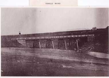 Clunes Museum
Photograph, PURCELL, ROGER, 1994
ORIGINAL PHOTOGRAPH OWNED BY MRS. LENA COOK OF CASTLEMAINE RD. CRESWICK.. THE PHOTOGRAPH WAS TAKEN LOOKING SOUTH WEST, THE SMALL COTTAGE SOUTH EAST OF HOLDING KNOWN AS 'STRAINS' ON THE CORNER OF BALLARAT AND COOK'S ROADS, MAY HAVE BEEN THE TOLL HOUSE. A WELL BESIDE THE COTTAGE IS STILL NEAR THE ROAD. BESIDE THE NEW TOURELLO BRIDGE..1 FRAMED PHOTOGRAPH OF TOURELLO BRIDGE ON BALLARAT RD. OVER COGHILLS CREEK. .2 BLACK & WHITE PHOTOGRAPH (COPY) .3 BLACK AND WHITE COPY OF ABOVE PHOTOGRAPHlocal history, photography, photographs, bridges -
 Lakes Entrance Historical Society
Postcard - Views of Lakes Entrance c1970, John Engelander and Co Melbourne, 1970 c
Princes Highway to town showing concrete bridge over North Arm . Also identical postcard with message on back in Spares boxColour postcard of view from Princes Highway to town showing concrete bridge over North Arm old toilet block opposite road to Bullock Island, Club Spit being formed, Hill 60 visible on outer barrier hummocks Lakes Entrance Victoriaroads and streets, township, waterways -
 Port of Echuca
Black & white photograph
Black & white photograph of 2 men, 1 girl and 1 boy on upper deck of P. S. Kelvin. In the background is a 3rd man, Hugh Price, at the wheel. Documented as being on mail run and at the Murray BridgeDemonstrates passenger transport and travel along the river as well as the delivery of mail services between rural communities.Black & white photograph of 2 men, 1 girl and 1 boy on upper deck of P. S. Kelvin. In background is a 3rd man, (Hugh Price) at wheel. Documented as being on mail run and at the Murray Bridge Echuca.In pencil on back : Kelvinp.s. kelvin, murray bridge, mail run, paddlesteamers, murray river, hugh price -
Eltham District Historical Society Inc
Photograph, Diamond Creek floods 1953, 1953
Three photographs of Diamond Creek in flood 21/10/1953 showing concrete bridge, Eltham South, Diamond Street bridge and Glen Park bridgediamond creek, floods, eltham, bridges, main road, wattletree road, diamond street, glen park -
![View of Sailor’s Creek Bridge / [by] Nicholas Caire, circa 1876](/media/collectors/550653872162f11fb04854aa/items/577b5b7ed0cdd10948d14ae1/item-media/577b5be9d0cdd10948d196a2/item-fit-380x285.jpg) Kew Historical Society Inc
Kew Historical Society IncPhotograph, Anglo-Australasian Photographic Company, View of Sailor’s Creek Bridge, c.1876
Nicholas Caire was born on Guernsey in the Channel Islands in 1837. He arrived in Adelaide with his parents in about 1860. In 1867, following photographic journeys in Gippsland, he opened a studio in Adelaide. From 1870 to 1876 he lived and worked in Talbot in Central Victoria. In 1876 he purchased T. F. Chuck's studios in the Royal Arcade Melbourne. In 1885, following the introduction of dry plate photography, he began a series of landscape series, which were commercially successful. As a photographer, he travelled extensively through Victoria, photographing places few of his contemporaries had previously seen. He died in 1918. Reference: Jack Cato, 'Caire, Nicholas John (1837–1918)', Australian Dictionary of Biography.An original, rare photograph from the series 'Views of Victoria: General Series' by the photographer, Nicholas Caire (1837-1918). The series of 60 photographs that comprise the series was issued c. 1876 and reinforced a neo-Romantic view of the Australian landscape to which a growing nationalist movement would respond. Nicholas Caire was active as a photographer in Australia from 1858 until his death in 1918. His vision of the Australian bush and pioneer life had a counterpart in the works of Henry Lawson and other nationalist poets, authors and painters.Views of Victoria (General Series) No.31 / ‘View of Sailor’s Creek Bridge’ / Albumen silver photograph mounted on boardOn Reverse" ‘Sailor’s Creek as situated in the Jim Crow Ranges, which Range forms a portion of the Great Dividing Range of Mountains in Victoria. These hills contain many romantic spots. The one which forms the subject of the present illustration is a view of the Bridge which spans the Creek. Gold has been found throughout the course of the bed of this Creek in payable quantities. The diggers, as may be seen in the photograph, have constructed sluices in the side of the embankment for the purpose of washing the fine gold contained in the wash-dirt.’nicholas caire (1837-1918), sailor's creek (vic), gold mining (vic) -
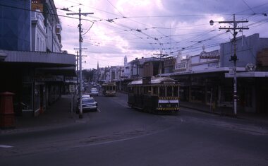 Ballarat Tramway Museum
Slide - 35mm slide/s, Peter Moses, 21/08/1971 12:00:00 AM
Photo of SEC Ballarat No. 42 after turning from Main St into Bridge St while running on the ARHS/TMSV special trams prior to closure. Tram 42 showing destination of "Special". No. 11 in the background. Kodak cardboard mount slide, taken by Peter Moses 21 August 1971.On the rear of the slides in blue ink "N42 Ballarat / Bridge St near Main St." and "P. Moses" in the bottom left hand corner in black ink on the other side of the slide.tramways, trams, bridge st, main st, special trams, tram 42 -
 Melbourne Tram Museum
Photograph - Colour Photograph/s, Jeff Bounds, 27/11/1988 12:00:00 AM
Colour print Ex Melbourne W2 class Nos. 456 & 470 on test run in Bridge St, at old loop, from cnr. Nolan St. / J. Bounds Photo 27/11/88" 456 has a The Met logo on the side.On rear in ink "Bendigo - Ex Melbourne W2 class Nos. 456 & 470 on test run in Bridge St, at old loop, from cnr. Nolan St. / J. Bounds Photo 27/11/88"trams, tramways, bendigo, w2 class, bridge st, tram 456, tram 470 -
 Warrnambool and District Historical Society Inc.
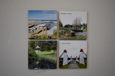
Domestic object, Drink Coasters (4)
These coasters depict scenes from Warrnambool – the Botanic Gardens, The Hopkins River mouth and the Wollaston Bridge. All are areas of historical and tourist interest. The coaster were produced to raise funds for Peters Project in Warrnambool, a charity organization dedicated to bringing improved cancer care services to Warrnambool. The organization was founded in 2008 by Vicki Jellie in memory of her husband Peter who died of cancer. The major aim of the organization was realized in 2016 when the South West Regional Cancer Care Centre was opened in a new building in Ryot Street and services to assist cancer patients in Warrnambool continue to be extended. These coasters are of some interest as examples of fund-raising material produced by the Peters Project committee to assist with the campaign to bring improved cancer care services to Warrnambool..1 .2.3.4 A wooden drink coaster with a felt base and a colour photograph pasted on the top section.1 Warrnambool Gardens .2 Hopkins River Mouth .3 Wollaston Bridge .4 Warrnambool Gardenspeter’s project, warrnambool, vicki jellie, warrnambool souvenirs -
 Lakes Entrance Historical Society
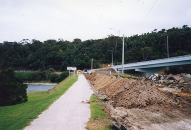
Photograph - Bridges, 2000
Date made May 2000.Colour photograph showing the removal of the road surface from the road approach and old concrete North Arm bridge prior to demolition of the bridge. Image shows the new bridge in background, earth moving machinery, and the North Arm waterway, and first rails of bridge removed by crane on bridge. Lakes Entrance Victoriabridges, waterways, demolition -
 Phillip Island and District Historical Society Inc.
Photograph
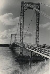
One of a collection of over 400 photographs in an album commenced in 1960 and presented to the Phillip Island & Westernport Historical Society by the Shire of Phillip IslandPhotograph of the First Phillip Island Bridge - a Suspension Bridge from San Remo to Newhaven.local history, photography, phillip island suspension bridge, black & white photograph, phillip island bridge, eastern passage, john jenner, bryant west -
 Bendigo Historical Society Inc.
Photograph - ROBERT DENIS KELLY COLLECTION: BRIDGE OVER RIVER
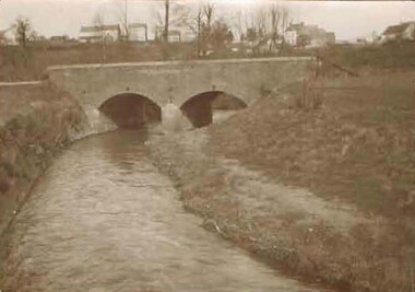
Black and white photo: a double arch bridge over river. On the back: Bridge Biesmes. -
 Bendigo Historical Society Inc.
Document - MIA MIA BRIDGE OR REDESDALE BRIDGE
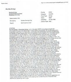
Mia Mia Bridge or Redesdale Bridge - description and history of - printed on white paper 21x30cm /document, mia mia bridge or redesdale bridge -
Bendigo Historical Society Inc.
Photograph - WINIFRED JENNINGS COLLECTION: MONIER BRIDGE, 1902
A photograph of Weerona Avenue's Monier Bridge testing failure in 1902. Here is a description from engineers australia.org detailing the bridges in Bendigo: "The 8 bridges in Bendigo represent the centre group of the 18 bridges built by Monash & Anderson under the Monier patents. The first group consisted of the two multi-span bridges at Fyansford and Wheelers Bridge in 1900. The eight Bendigo Bridges were built close together between 1901 and 1902. A further 7 Monier arch bridges were built at various other localities by Monash & Anderson during the period 1901 to 1913. "bendigo, history, early bendigo, weerona avenue, construction, incident. -
 Kew Historical Society Inc
Photograph - Johnston Street Bridge, 1952
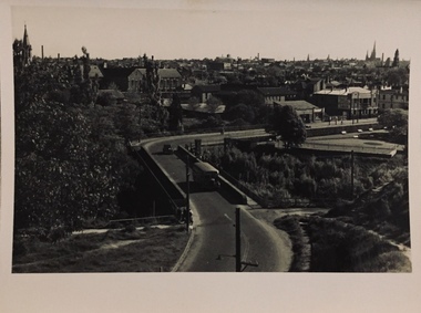
An item from an outstanding and diverse photographic collection, assembled by members of the Christian and Washfold families of Kew.Johnston Street Bridge before new bridge constructed. Bus on bridge, Abbotsford Convent on left and Melbourne skyline in distance. St Ignatius, Richmond without steeple.