Showing 1946 items matching "floods"
-
 Ringwood and District Historical Society
Photograph, Mullum Creek. Taken from footbridge at end of Adelaide St, Ringwood. Aug. 1973
See also 2983Backing sheet on two copies reads, "Mullum Creek, Aug. 1963. Taken from footbridge at end of Adelaide St." Other copy reads, "Same area of flooded Mullum Creek as photo 403. A week later 1963".(Photo 403 is RE34 in Record 2983) -
 Melbourne Tram Museum
Newspaper, The Herald, "Jail protesters paint trams", 23/02/1972 12:00:00 AM
Newspaper clipping titled - “Jail protesters paint trams” The Herald, Wednesday, Feb 23, 1972 Photos and text of vandalised trams at Preston workshops 20 trams, 40 men worked for an hour to remove the signs - graffiti - . Tram services not affected. Most of the trams were at Preston for repair after flood damage last week. See TMSV Running Journal April 1972 for details of the event.trams, tramways, preston workshops, graffiti, pentridge prison, protest -
 Bendigo Historical Society Inc.
Document - ELDORADO - THE STORY OF EL DORADO
Typed notes titled 'The Story of El Dorado' taken from the Mining & Geological Journal, dated January 1938 by D. G. Swift. Notes typed by L. G. Schilling, 13/10/69. Notes mention the disappointments, difficulties with water and the ground and floods, As well as gold they also found large quantities of tin oxide and a large variety of gemstones. A powerful jet of water was used for the mining.document, gold, eldorado, eldorado, the story of el dorado, mining & geological journal january 1938, d g swift, the argus 19/10/1855, kneebone & company, wellington party, mcevoy mine, kneebone mine, tin oxide, gemstones, united eldorado company, mining registrar, ovens gold and tin mining, eldorado extended, perserverance, great extended gold and tin mining, wellington company, mr william dunstan, united ovens gold and tin, the warrior, try again company, mcevoy disaster, cock's pioneer electric gold and tin sluicing company, mr h falsoner, cock's pioneer gold and tin mines n l company, state electricity commission, hydraulic sluicing, gold dredge, cock's eldorado company, l g schilling -
Tatura Irrigation & Wartime Camps Museum
CD, James Lally, Recollections of Tatura - Lally
Collection of photographs taken by Dr Desmond Lally and recorded onto CD by James Lally (son). Collection includes coronation procession 1953, Queen's visit 1954, floods 1956, old Tatura golf club 1964, Hill Top 1967.CD in a clear plastic rectangle cover. Black text on a silver disc. Contents of CD written on a piece of Verbatim Paper.local history -
 Eltham District Historical Society Inc
Negative - Photograph, Construction of the new concrete bridge over the Diamond Creek on Main Road, Eltham, c.May 1926
Construction of the new concrete bridge over the Diamond Creek on Main Road, Eltham, c.May 1926. Viewed from northern approach looking south east towards Eltham Park (Eltham Lower Park), showing the power lines that used to run in front of the park. The original long suspension bridge over the Diamond Creek on Main Road at Eltham collapsed during flooding of the Diamond Creek on October 13 and 14, 1923. The original bridge was built around 1840 for the coach road when Cobb & Co.'s coach was the only conveyance between Eltham and Melbourne. Widespread damage was done in Melbourne and surrounding areas by floods resulting from the overflow of the Yarra at many points along its banks. A temporary bridge rigged up was severely damaged by the flooding of the creek and was closed to vehicular traffic in April 1924. A new concrete bridge was constructed to replace it and by May 1926 all the concrete piles and abutments had been completed. The bridge was finally completed and opened for traffic in September 1926, almost three years after it initially collapsed.This photo forms part of a collection of photographs gathered by the Shire of Eltham for their centenary project book,"Pioneers and Painters: 100 years of the Shire of Eltham" by Alan Marshall (1971). The collection of over 500 images is held in partnership between Eltham District Historical Society and Yarra Plenty Regional Library (Eltham Library) and is now formally known as the 'The Shire of Eltham Pioneers Photograph Collection.' It is significant in being the first community sourced collection representing the places and people of the Shire's first one hundred years.Digital image 4 x 5 inch B&W Negshire of eltham pioneers photograph collection, bridge, bridge construction, cement mixer, diamond creek (creek), eltham, eltham lower park, eltham south, main road bridge -
 Eltham District Historical Society Inc
Photograph, Looking north along Main Road from Cecil Street intersection, Eltham, February 1968, Feb 1968
... floods ...Shows position of under road water course, which also went under railway line to the Diamond Creek and Cecil Street sign.In February 1968 an unknown person took a series of photos from the Eltham Hotel at Pitt Street heading north along Main Road through the shopping centre to just north of Elsa Court covering the length of the section of Main Road which was duplicated shortly thereafter. Shows the condition and environment of the streesscape of Main Road, Eltham immediately prior to the duplication between Pitt Street and Elsa Court through the shopping centre. Also shows a number of shops and businesses that operated at that time.Black and white photographduplication, eltham, main road, cecil street, railway line, watercourse, floods -
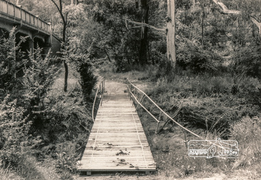 Eltham District Historical Society Inc
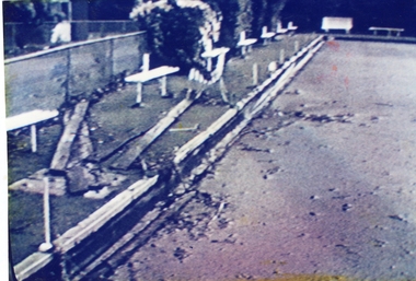
Photograph, Flood damage, Footbridge, Main Road, Eltham
... floods ...Black and white photographeltham, infrastructure, shire of eltham infrastructure, bridge, footbridge, main road, floods -
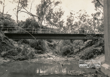 Eltham District Historical Society Inc
Photograph, Flood damage, Footbridge, Main Road, Eltham
... floods ...Black and white photographeltham, infrastructure, shire of eltham infrastructure, bridge, footbridge, main road, floods -
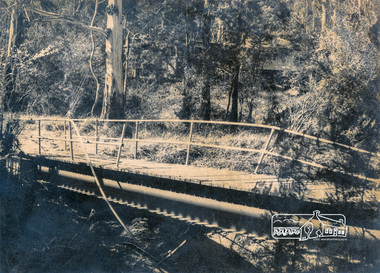 Eltham District Historical Society Inc
Photograph, Flood damage, Footbridge, Main Road, Eltham
... floods ...Black and white photographeltham, infrastructure, shire of eltham infrastructure, bridge, footbridge, main road, floods -
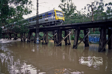 Eltham District Historical Society Inc
Photograph, Fred Mitchell, X'Trapolis Train crossing over the Railway Trestle Bridge at Eltham during Diamond Creek flood, 2005, 2005
... floods ...Digital copy of colour photographfred mitchell collection, 2005, diamond creek, electric train, eltham, floods, trestle bridge -
Merbein District Historical Society
Film, 1959 Jubilee Parade, Flood, Farm & Circus footage, 1950's
... Floods ...circus, merbein township, birthday celebrations merbein 1959, merbein jubliee celebrations, floods, paschendale avenue, keera station -
 Wodonga & District Historical Society Inc
Album - Hume Reservoir Australia Album - View from the Victorian bank of the Murray River, May 1923
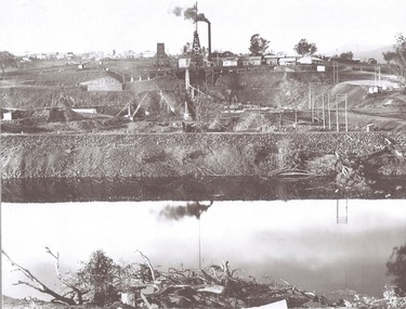
This set of photos is from a leather bound album bearing the inscription "HUME RESERVOIR AUSTRALIA" plus 'The Rt. Hon. L. C. M. S. Amery, P. C., M .P.' all inscribed in gold. It was presented to The Rt. Hon. L. C. M. S. Amery, P. C., M. P, Secretary of State for Dominion Affairs on the occasion of his visit to the Hume Reservoir on 2nd November 1927. This album is of local and national significance as it documents the planning and development of the Hume Reservoir up to 1927. It was the largest water reservoir in the British Empire. The album records the pioneering engineering work that went into its construction.DEPARTMENT OF PUBLIC WORKS, N.S.W. RIVER MURRAY WATERS SCHEME. HUME RESERVOIR. 12. View from the Victorian bank of the river showing in the foreground a levee bank along the New South Wales side of the river with connecting wings back to the higher ground, May 1923. The first stage in the construction of the Dam foundations was carried out inside the levee bank which was at a sufficient height to protect from floods the work going on inside. A length of 300 feet of the Dam was left at a low elevation to allow of the river flowing over it in the second stage of the operations and at the ends of the concrete was brought up above flood level. To divert the river, a Coffer Dam was built across the old bed above and below the Dam site and tying into the end of the concrete wall built inside the levee bank. This completely surrounded the remainder of the site of the Dam and south wing wall, including an area of 12½ acres.hume reservoir australia, river murray waters scheme, hume reservoir construction -
 Sunbury Family History and Heritage Society Inc.
Post Card, In and around Sunbury with Greeting
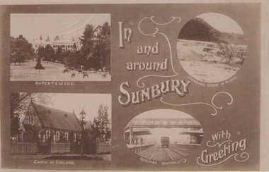
The post card is one of a set that were produced by Chris Christainsen, who had a pharmacy in Sunbury and was also a photographer. The four photos featured on the card are the Rupertswood Mansion, St Mary's Church of England, Jacksons Creek in floods ands Sunbury Railway station.The buildings and places featured on the card are of historical significance in the Sunbury town precinct. A post card with four sepia photographs of interesting sites which can be seen in the Sunbury township. IN AND AROUND SUNBURY WITH GREETING. christainsen, chris., rupertswood mansion, st. mary's church of england., jacksons creek, sunbury railway station -
 Kiewa Valley Historical Society
Photos - Tawonga Bridge x 2
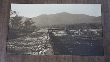
The first Tawonga bridge was built in 1884. It was destroyed by floods in 1916. The new bridge was constructed in 1923 and destroyed in 1953. The present concrete bridge was constructed in 1986 and named Ryders Bridge. Also refer to ?KVHS 0962 and KVHS 1051, KVHS 1090, KVHS 1123Bridge constructed over the Kiewa River in 1923 and destroyed in 1953.1. Dark Brownish photo framed by thin wood. Photo shows bridge with mountain behind and river and river bank in the foreground. 2. Small photo showing 2 sides of the bridge - a close up view.tawonga bridge, kiewa valley, kiewa river -
 Robin Boyd Foundation
Document - Script, Robin Boyd, The Flying Dogtor. Episode 8 The Dog Fight, 1963
The Flying Dogtor and Elvis Evil Eagle crashed mid air and the Dogtor helped Elvis gain control and rescued him. Thee Dogtor then tried to loosen a pile of logs that were blocking the creek and making the flood worse, but the effort sent his plane into a spin.The Flying Dogtor" series was broadcast on Australian Television Network (later becoming the Seven Network) between February and April 1964 (see item D254 for schedule).Typewritten, carbon copy, foolscap, 3 pagesPage 1: spelling correction, hand writtenthe flying dogtor, robin boyd, crawford productions, manuscript -
 Federation University Historical Collection
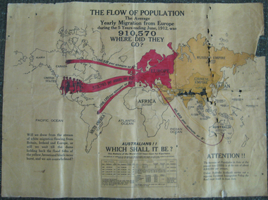
Poster, The Flow of Population, c1920
This posters advertises reasons for the migration of European (or white) people to Australia.Coloured poster on canvas showing the flow of World population around 1920 from Europe to Australia, Canada, the United States of America and South America. The poster appears to be pro the White Australia Policy with statements such as 'Will we draw from the stream of white migration from Britain, Ireland and Europe, or will we wait til the dams holding back the flood tides of the yellow, brown and black races burst, and we are overwhelmed?'migration, population, race, population statistics, migrations statistics, european immigration policy, white australia policy, racism, immigration, poster -
 Kew Historical Society Inc
Photograph - Yarra River, Kew, 1925
Henry Beater Christian (1886-1962) , was a descendant of one of the earliest settler families in Kew. Employed at the Kew Asylum as a 'public servant', he was a skilled amateur photographer, photographing numerous scenes in Kew and on his travels around Victoria. The majority of his photographs date from 1916 to 1929. His finest photographs are housed in two photograph albums. Digital copy of a photograph from page 3 of the 47-page photograph album containing 261 gelatinous silver images, loaned by Diane Washfold with permission given to digitise and hold a copy in our collection. The photograph is of a stretch of the Yarra River at Kew near Macauley's Boat Sheds. Of interest is the debris in the river which reminds us that the river periodically flooded, washing down trees and branches from further upriver. "Yarra Rvr / Kew / 1925"henry beater christian (1886-1962), landscape photography, kew (vic.) — yarra river, christian-washfold collection, photograph albums -
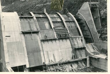
 Kiewa Valley Historical Society
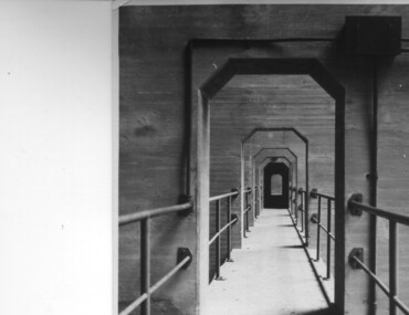
Photograph of Lake Guy Dam, Walkway, Inside Lake Guy Dam, c 1945
Lake Guy Dam is a 'slab and buttress' type wall. A timber frame is built and then filled with concrete. The first batch of concrete was placed in September, 1940. By June, 1941 the buttresses were finished to a height safe from floods and in October of that year a flood of 2,800 cusecs occurred but with only slight damage to the installations. Industrial trouble caused some delays but there was also slow progress on the part of the contractor and the work was taken over by the S.E.C., terminating the contract. The dam was completed in March, 1944. A walkway was made through the dam wall. Lake Guy was named after Mr. L.T. Guy who was the Resident engineer, in charge of construction work and associated activities on the Kiewa Area from 1939 to November 1946.Shows the walkway placed as part of the Lake Guy (Junction) Dam wall. A very good pictorial reference for the future.Black and white photograph of the walkway through Lake Guy (Junction) Dam wall.Handwritten in blue ink on back of photograph "Inside Lake Guy Dam". slab, buttress, dam, mr. l.t. guy -
 Orbost & District Historical Society
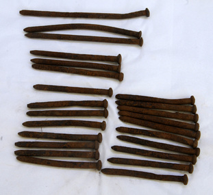
bridge spikes, 1922
These spikes are from the old Snowy River bridge (the second) constructed in 1922 alongside the previous suspension bridge. Its building was a combined effort of the Victorian Railways and the Country Roads Board at a cost of 35,000 pounds. It was replaced in 1976 by the present bridge after several major floods.These items are from a significant piece of infrastructure built in Orbost in the early 20th century. This bridge no longer exists.Twenty-four iron spikes of four different lengths. They are probably hand-made and have round shafts and heads. They are very rusty.snowy-river-bridge bridge-spikes bridge orbost -
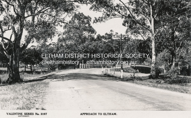 Eltham District Historical Society Inc
Postcard - Photograph postcard, The Rose Stereograph Company, Approach to Eltham, c.1939
Looking east along the unsealed main road heading into Eltham across the concrete bridge over the Diamond Creek circa 1939. The original wooden bridge was destroyed by flood waters in 1924. Valentine Series No. 3197 Postcard (Michael Aitkin Collection) dated Christmas 1943Postcard Digital file only Postcards scanned from the collection of Michael Aitken on loan to EDHS, 13 Feb 2018Valentine Series No. 3197bridge, diamond creek (creek), eltham, eltham south, main road, main road bridge, postcard, valentine series postcard, michael aitken collection -
 Ringwood and District Historical Society
Photograph, Ringwood Bowling Club- Flooding of greens, 1989
Colour photographPhotograph was taken off the video shots taken by Jack Shandley. The flooding occurred on 10th April, 1989, when four inches of rain fell in 1½ hours. Photograph shows how the West side of No 2 green looked next morning. Everything was covered with yellow mud and rubbish. -
 Eltham District Historical Society Inc
Slide, In Bonds Road looking north at intersection with Montpelier Drive, Lower Plenty, 18 July 1972, 1972
Water drainage work undertaken by Eltham Shire Council in Bonds Road, Lower Plenty outside the Martin property opposite Montpelier Drive, July 1972 Note water flooding across Bonds Road and pile of material removed from the pit on the east side of Bonds Road.35 mm colour positive transparency Mount - Agfacolor Service (Blue)Bonds Road (Martin property) 12.10 pm 18.7.72bonds road, drainage works, eltham shire council, infrastructure, lower plenty, martin property, montpelier drive -
Stawell Historical Society Inc
Realia, Hand Made Bricks from Carrs Plains Homestead c1860
Bricks made c1860 for Carrs Plains from local clay. House was to be double story but contractor built piles of bricks that were hollow and left after being paid. The house could only be single Storey. House flooded in 1974 but was lived in to 1983 by Ian Taylor & family.Three handmade bricks redish orange in colourhomestead -
 Bendigo Historical Society Inc.
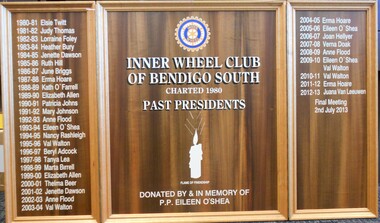
Memorabilia - INNER WHEEL CLUB SOUTH BENDIGO COLLECTION: HONOUR ROLL
Inner Wheel was established in 1924, initially for the wives of Rotary Club members. The first Victorian club was established in Ballarat in 1931 closely followed by Bendigo in 1933. The South Bendigo Club formed in 1980 and is one of over 700 clubs in Australia.Wooden, tri-foldout honour roll of Inner Wheel Club, Bendigo South. . Names of Past Presidents inscribed in white. On centre panel: ' Inner Wheel Club of South Bendigo, Chartered 1980, Past Presidents, Donated by and in memory of P.P Eileen O'Shea' Names on board either side of centre panel: 1980-81 Elsie Twitt 1982-83 Judy Thomas 1982-83 Lorraine Foley 1983-84 Heather Bury 1984-85 Jenette Dawson 1985-86 Ruth Hill 1986-87 June Briggs 1987-88 Erma Hoare 1988-89 Kath O'Farrell 1989-90 Elizabeth Allen 1990-91 Patricia Johns 1991-92 Mary Johnson 1992-93 Anne Flood 1993-94 Eileen O'Shea 1994-95 Nancy Rashleigh 1995-96 Val Walton 1996-97 Beryl Adcock 1997-98 Tanya Lea 1998-99 Marta Birrell 1999-00 Elizaabeth Allen 2000-01 Thelma B eer 2002-02 lJenette Dawson 2002-03 Anne Flood 2003-04 Val Walton 2004-05 Erma Hoare 2005-06 Eileen O'Shea 2006-07 Joan Hellyer 2007-08 Verna Doak 2008-09 Anne Flood 2009-10 Eileen O'Shea and Val Walton 2020-11 Val Walton 2022-12 Juana Van Leeuwen Final Meeting 2nd July, 2013.organisation, community, inner wheel bendigo south -
 Kiewa Valley Historical Society
Photo - Junction Dam Construction, Circa 1940's
Junction (Lake Guy) Dam is a 'slab and buttress' type wall. A timber frame is built and then filled with concrete. The first batch of concrete was placed in September, 1940. By June, 1941 the buttresses were finished to a height safe from floods and in October of that year a flood of 2,800 cusecs occurred but with only slight damage to the installations. Industrial trouble caused some delays but there was also slow progress on the part of the contractor and the work was taken over by the S.E.C., terminating the contract. The dam was completed in March, 1944. A walkway was made through the dam wall. Lake Guy was named after Mr. L.T. Guy who was the Resident engineer, in charge of construction work and associated activities on the Kiewa Area from 1939 to November 1946Photos of the construction of the Junction Dam detail the harsh conditions faced by construction workers, building dams and villages to accommodate workers in the 1940s to the 1950s. Australia at this period in time, experienced a surge of population (influx of World War II refugees), which was the catalyst for developing and undergoing an enormous hydroelectricity program for the Alpine regions, both in Victoria and New South Wales. This program was initiated to supply electricity to the major southern Australian cities of Adelaide, Melbourne and Sydney. It was thought that these developments would reduce, if not eliminate, the requirement for coal driven power stations. However time has demonstrated that these power stations have not matched the demand required by the industries and the populations of the major urban and cities.Black and white photograph of Junction Dam constructionjunction dam, bogong, secv -
 Kiewa Valley Historical Society
Photo - Junction Dam Diversion Tunnel
Junction (Lake Guy) Dam is a 'slab and buttress' type wall. A timber frame is built and then filled with concrete. The first batch of concrete was placed in September, 1940. By June, 1941 the buttresses were finished to a height safe from floods and in October of that year a flood of 2,800 cusecs occurred but with only slight damage to the installations. Industrial trouble caused some delays but there was also slow progress on the part of the contractor and the work was taken over by the S.E.C., terminating the contract. The dam was completed in March, 1944. A walkway was made through the dam wall. Lake Guy was named after Mr. L.T. Guy who was the Resident engineer, in charge of construction work and associated activities on the Kiewa Area from 1939 to November 1946.Diversion dams are installed to raise the water level of a body of water to be redirected. The redirected water is used for hydro electric power generation. A diversion tunnel is usually bored through solid rock next to the dam site to bypass the dam construction site. The dam is built while the river flows through the diversion tunnel.Photos of the construction of the Junction Dam detail the harsh conditions faced by construction workers, building dams and villages to accommodate workers in the 1940s to the 1950s. Australia at this period in time, experienced a surge of population (influx of World War II refugees), which was the catalyst for developing and undergoing an enormous hydroelectricity program for the Alpine regions, both in Victoria and New South Wales. This program was initiated to supply electricity to the major southern Australian cities of Adelaide, Melbourne and Sydney. It was thought that these developments would reduce, if not eliminate, the requirement for coal driven power stations. However time has demonstrated that these power stations have not matched the demand required by the industries and the populations of the major urban and cities.Black and white photograph of Junction Dam diversion tunnel at Bogong VillageHandwritten on back - Junction Dam Diversional Tunnelbogong, secv, junction dam, lake guy -
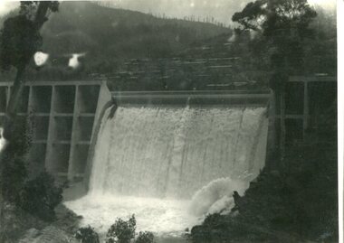 Kiewa Valley Historical Society
Photograph - Junction Dam spilling
Junction (Lake Guy) Dam is a 'slab and buttress' type wall. A timber frame is built and then filled with concrete. The first batch of concrete was placed in September, 1940. By June, 1941 the buttresses were finished to a height safe from floods and in October of that year a flood of 2,800 cusecs occurred but with only slight damage to the installations. Industrial trouble caused some delays but there was also slow progress on the part of the contractor and the work was taken over by the S.E.C., terminating the contract. The dam was completed in March, 1944. A walkway was made through the dam wall. Lake Guy was named after Mr. L.T. Guy who was the Resident engineer, in charge of construction work and associated activities on the Kiewa Area from 1939 to November 1946Photos of the construction of the Junction Dam detail the harsh conditions faced by construction workers, building dams and villages to accommodate workers in the 1940s to the 1950s. Australia at this period in time, experienced a surge of population (influx of World War II refugees), which was the catalyst for developing and undergoing an enormous hydroelectricity program for the Alpine regions, both in Victoria and New South Wales. This program was initiated to supply electricity to the major southern Australian cities of Adelaide, Melbourne and Sydney. It was thought that these developments would reduce, if not eliminate, the requirement for coal driven power stations. However time has demonstrated that these power stations have not matched the demand required by the industries and the populations of the major urban and cities.Black and white photograph of Junction Dam spilling at Bogong VillageHandwritten in pencil - Junction Dam spillingbogong, junction dam, lake guy, secv -
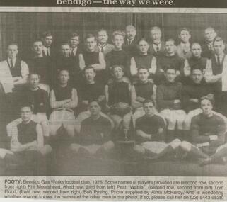 Bendigo Historical Society Inc.
Newspaper - JENNY FOLEY COLLECTION: FOOTY
Bendigo Advertiser ''The way we were'' from 2000. Footy: Bendigo gas works football club, 1926. Some names of players provided are: (second row, second from right) Phil Moorshead, (third row, third from left) Peat Wattie, (second row, second from left) Tom Flood, (front row, second from right) Bob Pysing. Photo supplied by Alma McHardy. The clip is in a folder.newspaper, bendigo advertiser, the way we were -
 Melbourne Tram Museum
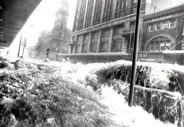
Photograph - Black & White Photograph/s, The Age, 17/02/1972 12:00:00 AM
Black and white photograph of a flood in Elizabeth St, with the GPO, Royal Arcade and London Stores in the background. Taken at the intersection with Flinders Lane. Shows a car with water washing over it and a safety zone in the background. Photograph by The Age, has a copy right stamp on the rear. Follows a massive downpour around the Queen Victoria Market. The cataloguer was working nearby in Collins St at the time, but no camera! See TMSV Running Journal April 1972 for details of the event.On the rear in pencil "Thursday 17/2/72 4 to 5pm, 3" Rain"trams, tramways, flooding, elizabeth st, gpo -
 Melbourne Tram Museum
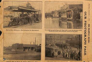
Newspaper, Australian Tramway & Motor Omnibus Employees Association (ATMOEA), "Our photograph Page", 9 and 11/1929
Newspaper clippings from The Tramway Record, 5/9/1929 and 28/11/1929, titled "Our photograph Page" featuring photographs of: .1 - Rail grinder in Melbourne, a single truck tramcar (M class 186) outside Hanna St depot after a thunderstorm and a flooded street, Hanna St depot and Circular Quay Sydney .2 - Y 410, W2 329, tourist bus, and interiors photos. Published by the ATMOEADated in ink on .2trams, tramways, grinder, work trams, buses, y class, interiors, flooding, atmoea, m class, hanna st depot, south melbourne depot, tram 186, tram 410, tram 329