Showing 780 items matching "frankston road"
-
 Surrey Hills Historical Society Collection
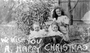
Photograph, Ruth, Lorna and Patience Cornell at Christmas, c1907
Children of Mr & Mrs Frank Cornell of 4-8 Lorne Parade. Frank Cornell was first listed in Surrey Hills in 1906 at (6) Lorne Parade. In 1908 the listing gives his occupation as a clerk. He was born in 1869 in Richmond, Victoria and died 15 April 1917 in Surrey Hills. Blanche Annie Parsons Cornell (nee Bracher) was born in 1869 in Hokitika, New Zealand; she died on 21 January 1940. Children were: Gilbert Frank Cornell (b1894, Hawthorn; d1908, at Frankston beach, an accidental drowning) Ruth Amelia Cornell (b 1899, Kew; d 29 May 1977, Kew) Lorna Amy Cornell (b 1906, Surrey Hills; d unknown) Patience Blanche Cornell (b1907, Surrey Hills; d unknown. Frank and wife Blanche are buried in Box Hill Cemetery - CE-*-1058. Ruth Amelia married David Ellis, c1922 in Surrey Hills. David was a dentist who practised in Surrey Hills for many years; practice located in Windsor Crescent. . Patience (Pat) Blanche married Norman Henry Brewer (1893–1975) in 1931 in Surrey Hills. The photo appears to be of the 3 girls. A black and white photograph of three children, two of whom are sitting in a wooden wheelbarrow. The image has a message "We wish you a happy Christmas" printed at the bottom of the card.(mr) frank cornell, (mr) (dr) david ellis, (miss) ruth cornell, surrey hills, windsor crescent, lorne parade, (miss) lorna cornell, (miss) patience cornell, christmas, (mrs) blanche annie parsons cornell -
 Surrey Hills Historical Society Collection
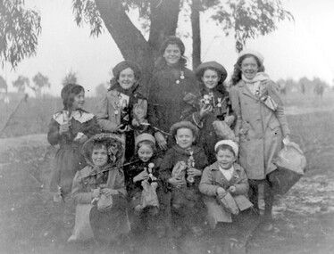
Photograph, Ruth Cornell and friends, 1902
Ruth Cornell is centre back surrounded by local school friends in 1902 after the presentation of medals in celebration of the birthday of Edward VII. Ruth was the daughter of Frank and Blanche Cornell. Frank Cornell was first listed in Surrey Hills in 1906 at (6) Lorne Parade. In 1908 the listing gives his occupation as a clerk. He was born in 1869 in Richmond, Victoria and died 15 April 1917 in Surrey Hills from a stroke. His wife Blanche Annie Parsons Cornell (nee Bracher) was born in 1869 in Hokitika, New Zealand; she died on 21 January 1940. Children were: Gilbert Frank Cornell (b1894, Hawthorn; d1908, at Frankston beach, an accidental drowning) Ruth Amelia Cornell (b 1899, Kew; d 29 May 1977, Kew) Lorna Amy Cornell (b 1906, Surrey Hills; d unknown) Patience Blanche Cornell (b1907, Surrey Hills; d unknown). Ruth Amelia married David Ellis, c1922 in Surrey Hills. David was a dentist who practised in Surrey Hills for many years. Patience (Pat) Blanche married Norman Henry Brewer (1893–1975) in 1931 in Surrey Hills. Dr David Ellis' surgery was in Whitehorse Road in 1930s and later at the corner of Windsor Crescent and Union Road. The donor was Ruth's sister. A black and white photograph of eight girls dressed up and proudly wearing medals and flags. Most are wearing hats and holding a bottle of drink.lorne parade, surrey hills, king's birthday, edward vii, festivals and celebrations, 1902, clothing and dress, (miss) ruth cornell, (dr) david ellis, (mrs) ruth ellis -
 Surrey Hills Historical Society Collection
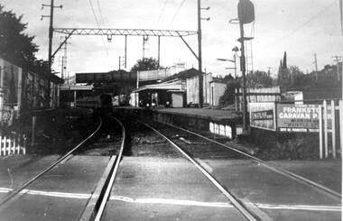
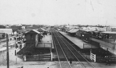
Photograph, Surrey Hills railway station, 1973, 1973
This would have been taken shortly before the station was demolished.Black and white photo of Surrey Hills railway station taken from the tracks near the gates in 1973. It shows the wooden pedestrian overpass and the original station buildings with extended shelters over the platforms.There is a newspaper kiosk on the southern platform. The train is coming into the platform and there is a small group of passengers waiting. Advertising hoarding for Spaceline Homes and the Frankston Caravan Park are mounted at the end of the southern platform. railways, land transport, surrey hills railway station -
 Vision Australia
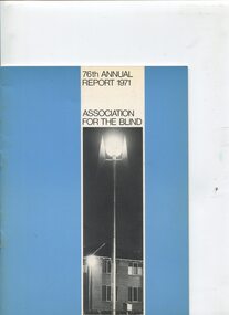
Administrative record - Text, 76th Annual Report 1971 Association for the Blind of Victoria, 1972
Articles in annual report include: branch committees, President's report, finance report, balance sheet, auxiliaries, volunteer service groups, in answer to your questions, senior staff, life governors, building of Katharine Rose wing at Bendigo, donation by G.W. Vowell of a 20 acre farm at Mt Eliza, new auxiliaries formed at Brighton, Kooyong, Bendigo and Mt Eliza with Guiding Light Group comprised of solely men, thanks to Flora Douglas for use of her home at Frankston and Audrey Moffat accepting responsibility for volunteer recruitment, and John Watson, a resident of Elanora, turned 100. 1 volume of text, photographs and illustrationsassociation for the blind, john watson, sir rohan delacombe, h.m. lightfoot, mirridong home (bendigo), kelaston home (ballarat), elanora home (brighton), annual reports -
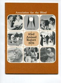 Vision Australia
Administrative record - Text, 83rd Annual report 1978 Association for the Blind of Victoria, 1979
Articles in annual report include: President's report, finance report, balance sheet, the Kooyong story 50 years of service to the blind, honorary services, blind members, life governors. 1 printed volume with illustrationsassociation for the blind, annual reports, henry bolte, h.m. lightfoot, john wicking, sir john wilson, john wilson, eunice wilson, p. daddo, frankston ladies choir -
 Vision Australia
Text, Association for the Blind George Vowell Branch Committee meeting minutes 10/2/1977-10/8/1988, 1977-1988
Minutes of the Mt Eliza branch committee (later known as the George Vowell branch committee) including centre activities, staffing changes, fund raising appointment and resignation of committee members and life governorships. Some highlights include: 9/5/1980 - the opening of the George Vowell Centre by Rt Hon Phillip Lynch, AFB President John Wicking and Mrs Kathleen Vowell. 16/9/1981 - the purchase of a Lowrey Debut Organ from Brash's Frankston for residents and day centre members to use. 12/11/1986 - the handing over the running of the annual fair in 1987 to a committee of volunteers rather than staff members.1 bookassociation for the blind -
Vision Australia
Text, RVIB Frankston Auxiliary, 1929 - 2011
... Vision Australia 454 Glenferrie Road Kooyong melbourne ...The Frankston RVIB Auxiliary formed on August 9, 1929 by Mrs Duke. This collection of papers includes the minute books from 1983 until 2011. The index cards were maintained by RVIB and contain the amount of donations made by the Auxiliary between 1976-1995, as well as the presentations delivered by RVIB employees to Auxiliary meetings between 1978-1985. 4 minute books -- banking records--various loose papers and letters royal victorian institute for the blind -
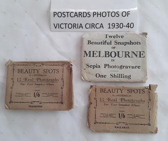 Mont De Lancey
Photograph - Photographs of Victoria, The Rose Stereograph Company, c 1930's - 1940's
The three envelopes of photographic cards have twelve various photographs of Melbourne, Frankston and Ballarat. Two sets are published by The Rose Stereograph Company in Armadale Victoria. Each card has a description of the photograph and where it is located.Three envelopes of 12 small beautiful sepia and black and white photograph snapshots of Melbourne, Frankston and Ballarat in Victoria. c1930 - 1940. The Melbourne packet is a grey paper envelope with Twelve Beautiful Snapshots of Melbourne in Sepia Photogravure One Shilling printed on the front. The two other beige envelopes have Beauty Spots in Australia 12 Real Photographs for your Snapshot Album Price 1/6 Priced in Australia by the Rose Stereograph Company Printers & Photographic Publishers Armadale Victoria. This is surrounded by an ornate border with Ballarat at the bottom and Frankston on the other.photographs, sepia photographs, souvenir photographs -
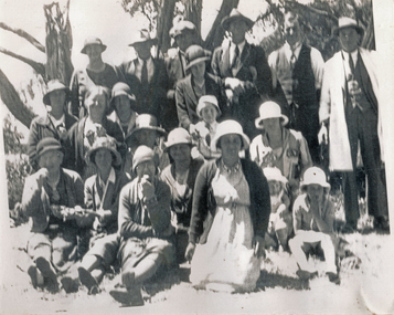 Wonga Park Community Cottage History Group
Photograph (sub-item) - Black and White, The Wonga Park Parents’ and Mothers’ Club at the annual school picnic (somewhere near Frankston) – The photo includes Mr. A.J. Upton, Mr. and Mrs. Lee, Mrs. Hogarth, Mrs. Menthe, Mr. Heims (white coat), c1933
-
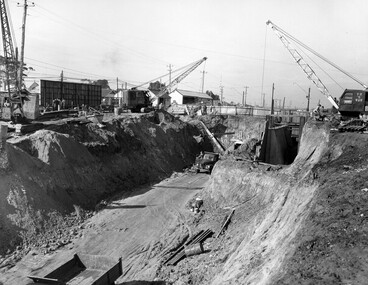 City of Kingston
Photograph - Black and white, c. 1958
Moorabbin station sits on the Frankston line which first opened in 1882 when the line was extended from Mordialloc. Moorabbin station opened in 1881 and was originally called South Brighton station. It was renamed Moorabbin station in 1907. In 1958 the station was relocated below street level which coincided with other construction works on Nepean Highway and South Road. This image is part of a larger collection of images from the Public Transport Corporation displaying train stations and streetscapes in what is now the City of Kingston.Black and white photograph showing excavations for Moorabbin station to be moved below street level. Stamped in blue ink on reverse: COPYRIGHT / Public Transport Corporation / For re-ordering photographs / Please quote negative No M6004 / Enquiries C/- PTC Photographic Unit / Telephone switchboard 619 111moorabbin, railway station, construction works, suburbs, nepean highway -
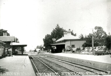 City of Kingston
Photograph - Black and white, Percy Fairlam, c. 1920
Cheltenham station was built in 1898 and serviced a primarily rural, market gardening community.The late 1870s saw the beginning of a massive program to construct railway lines throughout Victoria. One of these lines was from Caulfield to Frankston. A survey undertaken by J P Madden, an engineer employed by the railways, established the route, although this was later modified. At the time of the official opening of the line to Mordialloc no station buildings had been constructed despite the fact that tenders had been called in the Government Gazette of 26 May 1881 and subsequently in the Argus newspaper on 30 August 1881 for what became stations at Glenhuntly, Ormond, Bentleigh, Moorabbin, Highett, Cheltenham, Mentone and Mordialloc. However platforms and sidings were completed, ready to receive passengers. Cheltenham station opened in 1898.Black and white photograph of Cheltenham Railway Station with the two platforms separated by two sets of tracks. Each platform has a station house on it, and the one on the right hand side also has a garden and park bench.Handwritten in red ink on reverse: A7 / 75%cheltenham, trains, railway, railway station, railway crossing, suburbs -
City of Kingston
Photograph - Colour, 1993
Carrum is a suburb in the City of Kingston bordered by the Patterson River in the north and Kananook Creek in the south. To the east the suburb is adjacent to Patterson Lakes. The Carrum Station was opened in 1882, when the railway line from Mordialloc was extended to Frankston. In the early 20th century, it was a destination for holidaymakers occupying tents and cabins. The area now consists of older housing and over time there have been many new housing developments.Carrum is located in the area that was originally part of the Carrum Carrum Swamp. The district had originally been the home of the Bunerong people who fished, gathered food and found refuge in the sand dunes. The Swamp was drained in 1879 when the Patterson Cut was formed and became known as Patterson River. Apart from local farmers, fishermen and hotel-keepers, there were few permanent residents until the early 20th century when it had become popular as a beach resort. In the 1920s and 1930s the area became occupied by more permanent residents.Laminated aerial colour photograph of Carrum and Patterson Lakes in the City of Kingston. The photograph also includes Kananook Creek and the northern section of Seaford. Prominent features include Roy Dore Reserve, Carrum Primary School, Patterson River Secondary College, Keast Park Seaford, the Seaford Swamp Drain and a section of Downs Estate situated on the traditional lands of the Bunurong people.Black type on white adhesive sticker: No. 7140 Black type of white adhesive sticker: 31-1-93 Black handwritten ink (marker): * [an asterisk] Yellow circular adhesive stickerpatterson lakes, seaford, carrum carrum swamp -
City of Kingston
Photograph - Black and white, 17 January 1951
Moorabbin, Cheltenham and Highett are suburbs in the City of Kingston with a diverse mix of development and zoning. This 1954 image shows the market gardens, farms and paddocks of the Moorabbin and Cheltenham area. which have gradually been sub-divided into The Highett Gas Works is visible and Cheltenham Park and Victoria Golf Club.The suburbs of Cheltenham and Moorabbin were originally developed with extensive market gardens. Over time the district has been transformed with the farms and paddocks replaced by housing, factories and shopping centres. The Highett Gas Works on the Nepean Highway was a significant feature of the landscape and has now been demolished. and the site has undergone remediation.Aerial photograph of Cheltenham, Moorabbin and Highett within the City of Kingston. The area depicted in this 1951 aerial view includes Wickham Road, Highett (bottom right), Keys Road, Moorabbin (bottom left), Centre Dandenong Road Cheltenham (top left), Park Road, Cheltenham (top right), Nepean Highway (left section), Graham Road and Middleton Street, Highett (bottom right). Cheltenham Park and Victoria Golf Club are visible. Nepean Highway and the Frankston railway line run centrally through the image.White type: 1416-37 538 RUN239 LENS 5312" MELBOURNE METROPOLITAN 12150 17-1-51 ↆ M539 Black pencil: N [arrow]cheltenham, highett, highett gas works, market gardens -
City of Kingston
Photograph - Black and white, 3 March 1954
Cheltenham and Moorabbin are suburbs within the City of Kingston that were originally established as rural market gardening communities The area is bordered by Highett and Mentone. The market gardens, farms and paddocks have gradually been sub-divided into housing and industrial estates. Highett is developed with residential homes but was also the site of major facilities such as the Highett Gas Works. This aerial image covers a diverse section of the City of Kingston, taking in the suburbs of Moorabbin, Cheltenham, Highett and Mentone Residential housing development is prominent along the Frankston Railway line and the area still retains extensive market gardens and paddocks yet to be converted to a large industrial and commercial zone.Aerial photograph of Mentone, Cheltenham and Moorabbin within the City of Kingston. The area depicted in this 1954 aerial view includes Warrigal Road and Centre Dandenong Road intersection (top left); Charman Road, Patty Street, Bourke Street, Collins Street Mentone (top right); Keys Road Moorabbin (bottom left); Bay Road, Cheltenham (bottom right), Friendship Square, Cheltenham Park, Victoria Golf Club and Jack Barker Oval are visible. Nepean Highway and the Frankston railway line run centrally through the image. Highett Gasworks is also evident.White handwriting and type [indecipherable]. White image of clockface White image of compass White type 42956 Black handwriting 3/3/54 Williams [indecipherable] Black pencil: S [arrow] Black ink: 3/3/1954cheltenham, moorabbin, mentone, highett, market gardens -
 City of Kingston
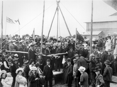
Photograph - Black and white, 1909
In 1880, the Melbourne Benevolent Asylum launched an appeal to raise funds to relocate away from the inner city. The location in North Melbourne was considered a great risk for the residents, particularly the 'old and feeble', in the event of an epidemic. In 1887, the secretary to the Premier of Victoria wrote to the Asylum, suggesting Frankston as a possible alternative to North Melbourne. The Asylum committee considered Frankston to be too far away. The Royal Commission into Charitable Organisations (1890) strongly recommended Cheltenham as the preferred location but the government failed to act on that recommendation. Former Asylum committee member, Mr James Hingston, bequeathed £25,000 to the Asylum on his death in 1902. After many more years of toing and froing, the foundation stone for the new asylum at Cheltenham was laid in 1909. It was almost two years later that the transfer of residents from North Melbourne to Cheltenham began. The move happened in stages over three days, with the first group of residents to move to Cheltenham being 125 women from the invalid wards. The Asylum continued to operate throughout the 20th Century and, in 1970, was renamed the Kingston Centre. The focus of services also changed. This photograph captures the laying of the foundation stone in 1909.Black and white image depicting a large group of citizens gathered to watch the laying of the foundation stone for the Benevolent Asylum in Cheltenham. There is a raised platform with a group of men dressed in suits standing on it. These appear to be the dignitaries for the day. There are flags flying in the background, others standing on poles at the corners of the raised platform. Handwritten in red ink on reverse: 50%cheltenham, charity, north melbourne, welfare -
 City of Kingston
Photograph - Digital image, Black and white, c. 1910
Black and white image of Chelsea Railway Station showing the impact of the railways on the development of the area. Shops and shoppers can be seen behind the station buildings.The extension of the railway line from Mordialloc to Frankston influenced the development of the villages along the train line. Shops and community buildings were built in proximity to the station, along with the subdivision of land for houses. Black and white image of Chelsea Railway Station showing platforms and local shopschelsea, railway station, railway, shopping strip, public transport -
 City of Kingston
Pamphlet - Colour, Roy Dunn Pty. Ltd, Subdivisional auction of Highett Station Estate, c.1924
Sales plan for land in the suburb of Highett, bounded by Worthing Road, and the Melbourne to Frankston Electric Railway Line, including LePage Street. The developing urban area of Highett within the City of Kingston. This land sale pamphlet illustrates the subdivision of land within the municipality and the changing demographic of the district as new houses are constructed close to infrastructure.Colour pamphlet advertising a subdivisional auction of the Highett Station Estate. Incorporates a map of the estate bordered by Worthing Road and the Melbourne to Frankston Electric Railway, and including LePage Street. Handwritten in black ink on front cover: Late LePage / Wickham Rdland sales, estate, highett -
 City of Kingston
Photograph - Black and white, c. 1908
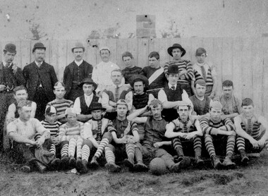
Australian rules football began being played on a regular basis in Cheltenham in 1890. Teams would not only play locally but travel by train fairly long distances, such as to Ballarat, for the day, play a game, turn around and come home. The Cheltenham home games were played on a paddock on the corner of Park and Charman roads in Cheltenham. In 1907 the Cheltenham progress committee made an application to the board of land works for land in Weatherall Road for recreational service to the public. That application was received and granted, then developed where Cheltenham Recreational Reserve now stands. The ground was opened in 1909 and the first Cheltenham side entered in the newly formed Federal Football League along with seven other foundation members, Mordialloc, Mentone, Moorabbin, Frankston, Glenhuntly, Elsternwick, and Ellindale. The grand final for that year, 1909 was a hard encounter between Cheltenham and Ellindale with Cheltenham coming out victors, thus becoming the inaugural Federal Football League premiers. The Federal Football League (FFL), also known simply as the Federal League, was an Australian rules football competition in the south-eastern suburbs of Melbourne, Victoria. The competition was in existence from 1909 to 1981 and was regarded as one of the strongest metropolitan leagues in Melbourne.Black and white image of the players and officials of the Cheltenham Football Club. Back (left to right) G Puttick, Franklyn (sic), Unkown, Unknown, C Corstorphine, D Arland, Dave Hughes, H Bryant, Centre: T Elliott, S Parsons, F Judd, H Foreman, N Corstorphine, J McCormack, S Chandler, H Orr. Front: H Clayton - no other names recorded. The players are wearing what appears to be a range of club jumpers, with some in street wear. Some players seated in the front row have mud visible on the soles of their shoes, indicating they may have already played a gam. The ball on the ground in front of the group is round.Round red sticker on reverse with handwritten text: X10 Handwritten in blue ink: A11, with a circle around it Handwritten in red ink: 50%sport, football, cheltenham, teams, federal football league -
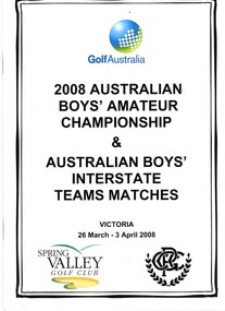 Heidelberg Golf Club
Booklet, Golf Australia, 2008 Australian Boys’ Amateur Championships, and Australian Boys’ Interstate teams matches. Victoria 26 March – 3 April 2008, 2008
Official guide to the 2008 Australian Boys’ Amateur Championships, and Australian Boys’ Interstate teams matches. Victoria 26 March – 3 April 2008. Played at Spring Valley Golf Club (Clayton South) and Peninsula Golf Club (Frankston). Victorian team Manager Bruce Harding. Coach David Capaldo. Team members: Lachlan Cain, Geoff Drakeford, Jordan Hampton, Anthony Houston, Will Hume, Bryden Macpherson This team won Australian Championships at Peninsula Golf Club. Includes 'Pro Yardage" booklet on the length and layout of each hole at Peninsula Golf Club. Former HGC President Bruce Harding was involved with Victoria's Junior teams from 2000-2010.Booklet 28 p., black text, illus. (some col.). Includes photographs of players. Pro yardage 19 p., maps.bruce harding, australian junior amateur championships, junior golf -
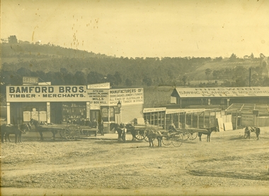 Ringwood and District Historical Society
Photograph, Maroondah Highway Central, Ringwood. Bamford's Timber Yard, 1910
Sepia photographImage shows timber yard with men and horse-drawn vehicle outside building. Warrandyte Road on right leading to Kennedy's orchard. Shop on corner was 'A. Wagner, Hairdresser. Photograph received from a Mr. Harrison, E.S.& A Bank Manager , Frankston. (Peter Paynes photographer). -
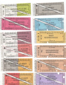 Melbourne Tram Museum
Ephemera - Ticket/s, Metropolitan Transit Authority (MTA), Set of 18 The Met Neighbourhood tickets, 1986 to 1988
Set of 18 The Met Neighbourhood tickets, printed on paper for the 1983 to 1989 era. Availability dates printed on ticket. Conditions of use printed on rear. .1 - Werribee plus inner Concession, - 90c, May / June, No. 04034 .2 - Frankston plus one Concession, - 80c, May / June, No 05046 .3 - Box Hill Plus one Concession, - 80c, May / June, No 4487 .4 - Broadmeadows Concession, - 35c, May / June, No 28032 .5 - St Albans - 40c, Concession, Feb / Mar 1988 No. 12503 .6 - Inner - $1.30 Jan/Feb 1988 - No. A561125 .7 - Greensborough, Concession, 35c, Feb. 1987, No. 059474 .8 - Werribee Concession, 35c, May / June No. 04048 .9 - Greensborough, 70c, Feb. 1987 No. 028065 .10 - Box Hill plus inner concession, 90c May/June No. 14546 .11 - Moorabbin concession, 45c, July/Aug 1988 - No. 0235210 .12 - Inner concession, 60c, Jul/Aug 1988 - No. 737408 .13 - Anywhere - not priced, Feb/Mar. 1986 No. 087866 .14 - Frankston, 80c, May / June No. 29535 .15 - Ringwood, 70c, May / June No. 73736 .16 - Box Hill plus one, $1.60, Dec/Jan No. 07314 .17 - Broadmeadows plus inner - $1.80, May / June No. 23034 .18 - Ringwood plus one concession, 80c, May / June No. 06035.trams, tramways, tickets, the met, ptc, travel cards -
 Melbourne Tram Museum
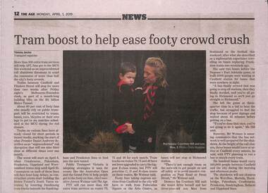
Newspaper, The Age, “Tram boost to help ease footy crowd crush”, 1/04/2019 12:00:00 AM
Newspaper clippings titled: “Tram boost to help ease footy crowd crush” Newspaper clipping from the Age 1/4/2019 by Timna Jacks - Transport Reporter More than 100 extra tram services on routes 70, 75 and 48 scheduled for this weekend for the football this weekend due to planned rail shutdown on the Frankston line. Tram tracks on routes 48, 70 and 75 have not been upgraded to carry E-class trams, but PTV will prioritise C, D and B-class trams for these routes.trams, tramways, public transport, route 70, route 48, route 75 -
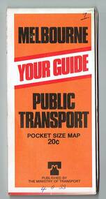
 Melbourne Tram Museum
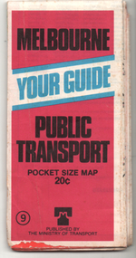
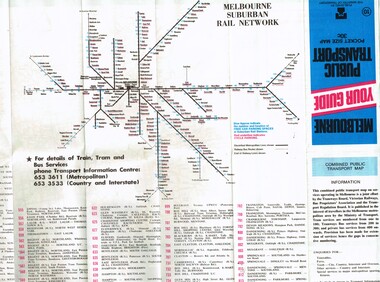
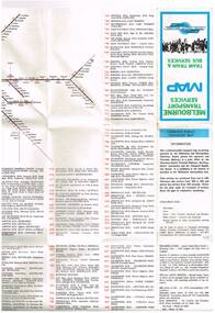
Ephemera - Map, Ministry of Transport, "Melbourne Your Guide PUblic Transport Pocket size map", 1979
Provided a detailed map of Melbourne's public transport, route number list and brief description. Has contact details for bookings and lost property etc. Priced 20c, published 1979 as map No. 9Demonstrates the methodology of providing map and transport information at the time.Fold out map (27 sections 9 across x 3 deep), coloured of Melbourne's Tram and Bus routes, route numbers, rail lines, detailed for the central part of Melbourne and insert section for Frankston. melbourne, map, tram and bus services, railways, mmtb, ministry of transport -
 Melbourne Tram Museum
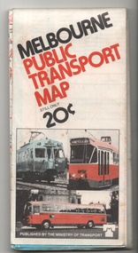
Map, Ministry of Transport, "Melbourne Your guide public transport", 1980
Fold out map (27 sections 9 across x 3 deep), coloured of Melbourne's Tram and Bus routes, route numbers, rail lines, detailed for the central part of Melbourne and insert section for Frankston. On rear description of routes, private bus routes and map of Melbourne metro lines. Has contact details for bookings and lost property etc. Priced 30c No. 11 Dated 1980 on rear .1 - 1 as above, blue cover, No. 10, also dated 1980.trams, tramways, melbourne, map, tram & bus services, railways, mmtb, minister for transport -
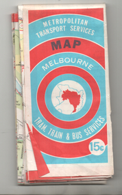
 Melbourne Tram Museum
Map, Ministry of Transport, "Melbourne Transport Services Map - Tram, Train and Bus Services", c1975
Fold out map (27 sections 9 across x 3 deep), coloured of Melbourne's Tram and Bus routes, route numbers, rail lines, detailed for the central part of Melbourne and insert section for Frankston. On rear description of routes, private bus routes and map of Melbourne metro lines. Has contact details for bookings and lost property etc. Not priced. Not dated, but circa 1975 - has map scale in kms and route 59 to Essendon Airport still extends into Airport. 2nd copy added 16/7/2014. See Reg Item 521 for issue No.. 2, 1974.On front cover in ink "issue #3" in top right hand corner and "4 G 33" along bottom edge.trams, tramways, melbourne, map, tram & bus services, railways, mmtb, minister for transport -
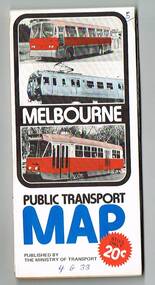
 Melbourne Tram Museum
Map, Ministry of Transport, "Melbourne Public Transport Map", c1977
Fold out map (27 sections 9 across x 3 deep), coloured of Melbourne's Tram and Bus routes, route numbers, rail lines, detailed for the central part of Melbourne and insert section for Frankston. On rear description of routes, private bus routes and map of Melbourne metro lines. Has contact details for bookings and lost property etc. Priced 20c Dated 1977, says No. 6 on bottom of rear cover. Note shows route 59 being cut back to the highway.trams, tramways, melbourne, map, tram & bus services, railways, mmtb, minister for transport -
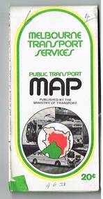
 Melbourne Tram Museum
Map, Ministry of Transport, "Melbourne Transport Services Map - Tram, Train and Bus Services", c1974
Fold out map (27 sections 9 across x 3 deep), coloured of Melbourne's Tram and Bus routes, route numbers, rail lines, detailed for the central part of Melbourne and insert section for Frankston. On rear description of routes, private bus routes and map of Melbourne metro lines. Has contact details for bookings and lost property etc. Priced 15c Inscription dates the map as 1974. Two copies held.On front cover in ink "#3" in top right hand corner and "4 G 33 1974" along bottom edge of the first copy.trams, tramways, melbourne, map, tram & bus services, railways, mmtb, minister for transport -
 Melbourne Tram Museum
Map, Ministry of Transport, "Melbourne Transport Services Map - Tram, Train and Bus Services", 1975-1976
Fold out map (27 sections 9 across x 3 deep), coloured of Melbourne's Tram and Bus routes, route numbers, rail lines, detailed for the central part of Melbourne and insert section for Frankston. On rear description of routes, private bus routes and map of Melbourne metro lines. Has contact details for bookings and lost property etc. Priced 20c possible 1975-1976 - has 1041 and silver train on front cover.On front cover in ink "3" in top right hand corner and "4 G 33 " along bottom edge.trams, tramways, melbourne, map, tram & bus services, railways, mmtb, minister for transport -
 Melbourne Tram Museum
Map, Ministry of Transport, "Melbourne Transport Services Map - Tram, Train and Bus Services", 1976
Fold out map (27 sections 9 across x 3 deep), coloured of Melbourne's Tram and Bus routes, route numbers, rail lines, detailed for the central part of Melbourne and insert section for Frankston. On rear description of routes, private bus routes and map of Melbourne metro lines. Has contact details for bookings and lost property etc. Priced 20c Has a bus, silver train and a Z class tram on the cover. On bottom of outside cover, "No. 5 1976"On front cover in ink "5" in top right hand corner and "4 G 33 " along bottom edge.trams, tramways, melbourne, map, tram & bus services, railways, mmtb, minister for transport -
 Melbourne Tram Museum
Map, Ministry of Transport, "Melbourne Transport Services Map - Tram, Train and Bus Services", 1977
Fold out map (27 sections 9 across x 3 deep), coloured of Melbourne's Tram and Bus routes, route numbers, rail lines, detailed for the central part of Melbourne and insert section for Frankston. On rear description of routes, private bus routes and map of Melbourne metro lines. Map No. 7, 1977. Has contact details for bookings and lost property etc. Priced 20c. 1977, route 59 showing as terminating opposite Essendon Airport.On front cover in ink "" in top right hand corner and "4 G 33 " along bottom edge.trams, tramways, melbourne, map, tram & bus services, railways, mmtb, minister for transport