Showing 1185 items matching "municipality"
-
 Bendigo Historical Society Inc.
Memorabilia - FRAMED IMAGE OF BENDIGO MAYORAL CHAIN
Large framed item. At the centre a photograph of the Bendigo Mayoral Chain designed and manufactured by F. Prescott, jeweller, Bendigo At the right a photo of George Lansell esq. and on the left a photo of J.H. Abbott esq. A list of Mayor is underneath the two photos, starting from the left J.F. Sullivan 1857, J.H. Abbott 1860, J.J. Casey 1861, R. Burrows 1862, G. Aspinall 1869, J. Boyd 1870, G. Aspinall 1873, J.A. Woodward 1874, H.Hattam 1876, E. Neil 1876, A. Bayne 1877, J.A. Woodward 1879, P. Hayes 1880, W.G. Jackson 1881, A. Harkness 1882, S.H. McGowan 1885, P. Hayes 1886, T.J. Connelly 1887, J. Cohn 1888, J.P. Carolin 1889, J,R. Hoskins 1890, J.H. Abbott 1891-92-95. Under the Mayoral chain the words: Bendigo gold fields discovered 1851. Proclaimed municipality of Sandhurst 1855 and city in 1871. Name changed to City of Bendigo in honor of which event cnr. J.H Abbott inaugurated the mayoral chain and the medallion was presented to the City Council by George Lansell esq. To whose implicit belief in the inextinguishable nature of our gold resource and the indefatigable energy in developing them Bendigo manly owes its present prosperity. July 1893, W. Honeybone Town Clerk and signed by F. Prescott.bendigo, council, mayoral chain, from dudley house stored at bendigo art gallery from 2000, returned to bhs 03/02/2023 -
 City of Moorabbin Historical Society (Operating the Box Cottage Museum)
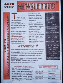
Newsletter - City of Moorabbin Historical Society Apr 2007, April 2007 1st Issue, April 2007
The City of Moorabbin Historical Society was formed c 1960 by a group of Moorabbin area residents who were concerned that the history of the area should be preserved. The approaching Centenary of the area as a Municipality in 1962 , - formation of the Moorabbin Roads Board 1862, - encouraged interest in the ‘History of Moorabbin’ and the Mayor Doug Clark was persuaded to call a public meeting for the formation of an Historical Society. Thirty citizens attended this meeting in November 1960 at which Mr Latham , Royal Historical Association, encouraged them to do so. Mr Tom .A. Sheehy, Author of ‘Battlers tamed a Sandbelt - Moorabbin 50 years a City ‘, moved for the formation of the ‘City of Moorabbin Historical Society’, and was seconded by Councillor E A Le Page. A vote was taken among attendees and Mr Tom A Sheehy was elected Foundation President, Cr E A Le Page Vice President, Mr J A Stretton Secretary and they and the other members “ began a programme of research in order to have reliable information available in time for the Centenary.” p148 Following a call for donations of items of Historical interest, the residents of the City of Moorabbin donated a wide variety of artefacts, photographs, household goods, farm machinery, letters, documents, clothing, and personal effects which have been carefully preserved by succeeding CMHS members and are displayed at Box Cottage Museum. Helen Stanley has produced a bi-monthly Newsletter, 2007 - 2013, for the members of the City of Moorabbin Historical Society that contains well researched interesting historical items, notification of upcoming events, current advice from Royal Australian Historical Society , Museums Australia Victoria and activities of Local Historical Societies. The Newslletter is an important record of the activities of CMHSA4 paper printed both sides x1 This is the first of the bi-monthly, City of Moorabbin Historical Society Newsletter produced by Society member and Secretary, Mrs Helen Stanley in April 2007. An introductory paragraph is followed by notification of upcoming meeting in May 27th 2007 at which Ms Vicki Court, RVHS, will talk about small historical groups and on 28th October 2007 Dr Graham Whitehead, City of Kingston Historian, will discuss ‘Murder’ in Moorabbin Shire. A photocopy of an advertisement, in the ‘Cheltenham Leader’ September 17th 1887, by Chemist J.H.Niemann , of Middle Brighton.. On the reverse side of the Newsletter Helen provides quotes from a Box Cottage Museum library book “ The Colonial Child” describing ‘larrikins’ in the streets of Melbourne c1880 and the damage to roadways caused by the heavily laden horse-drawn lorries. A roster of members is given for attendance at Box Cottage monthly open daysCITY of MOORABBIN HISTORICAL SOCIETY / APRIL 2007 NEWSLETTERcity of moorabbin historical society, sheehy tom a, le page e a, stretton j a, clark doug, stanley helen, court vicki, whitehead graham, neimann j a, chemists, pharmacy, druggists, melbourne, moorabbin, brighton, cheltenham, ormond, bentleigh, cheltenham leader newspaper, sharpe valma, sturt lesley, lawson nan, featherstone guy, the colonial child, box cottage museum, battlers tamed a sandbelt, moorabbin roads board, steel plateway, market gardeners, pioneers, early settlers, moorabbin shire -
 Port Fairy Historical Society Museum and Archives
Postcard - Pencil Drawing
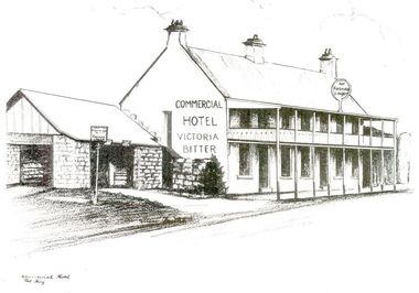
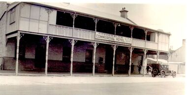
John J. Huntly appears to have been the only licensee of the Royal Oak Hotel, built in 1858. He was a Councillor of the Municipality of Belfast at the time and later became the Secretary of the newly formed Minhamite Shire in 1872. By 1861 D. Smith appears as the licensee of the now named Commercial Hotel. In 1877 it was offered for sale—the building described as follows “Built of bluestone with slate roof, having a frontage to Bank street of 106 feet, 6 inches. Accommodation consists of twelve bedrooms, eight sitting rooms, bathroom, bar and cellar and detached kitchen also of bluestones, with outside offices. Around this time beside its usual business the hotel had various rooms for visiting doctors and a dentist. Dr. Berncastle, who was associated with the Sydney Eye Infirmary, performed several operations there on those suffering from cataracts. It was the meeting place for the Port Fairy Freemasons, before their Lodge was built in James street, and all the local sporting clubs, at one time or another. The veranda was added in 1900. The name Royal Oak was restored this century, but the name Commercial Hotel can still be seen in the leadlight window over the front entrance. The hotel still continues serving patrons with beverages and meals but no beds these days. There is also an addition to the building, as seen in the bottom illustration— a bottle shopBlack and white sketch photographed Line drawing of the Commercial hotelhotel, building, commercial, oak and anchor, inn, pub, d.smith -
 Port Fairy Historical Society Museum and Archives
Photograph
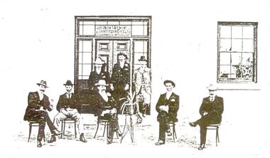
John J. Huntly appears to have been the only licensee of the Royal Oak Hotel, built in 1858. He was a Councillor of the Municipality of Belfast at the time and later became the Secretary of the newly formed Minhamite Shire in 1872. By 1861 D. Smith appears as the licensee of the now named Commercial Hotel. In 1877 it was offered for sale—the building described as follows “Built of bluestone with slate roof, having a frontage to Bank street of 106 feet, 6 inches. Accommodation consists of twelve bedrooms, eight sitting rooms, bathroom, bar and cellar and detached kitchen also of bluestones, with outside offices. Around this time beside its usual business the hotel had various rooms for visiting doctors and a dentist. Dr. Berncastle, who was associated with the Sydney Eye Infirmary, performed several operations there on those suffering from cataracts. It was the meeting place for the Port Fairy Freemasons, before their Lodge was built in James street, and all the local sporting clubs, at one time or another. The veranda was added in 1900. The name Royal Oak was restored this century, but the name Commercial Hotel can still be seen in the leadlight window over the front entrance. The hotel still continues serving patrons with beverages and meals but no beds these days. There is also an addition to the building, as seen in the bottom illustration— a bottle shopBlack and white photograph of 8 males formally posed outside entrance to Commercial hotelhotel, building, kemp family, bank street, royal oak, commercial, oak and anchor, d.smith -
 Melton City Libraries
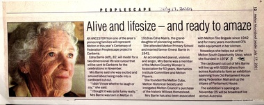
Newspaper, Edna Barrie, 1997,2001
"Edna Barrie is one of countless women who have played a crucial role in the Melton communityover its history. She was a tireless volunteer and a stalwart of the community who helped to keep many organisations running and thriving. Edna was born in 1918 into a family with deep roots in Melton. Her grandmother Ann Dowling arrived in the colony from Ireland with her two sisters in 1855. Ann purchased land in Melton and settled on the Ballarat Road (High Street) at Ryans Creek with her husband Henry Myers. The three Dowling sisters had ten children between them who attended Melton State School No. 430, as did Edna. Edna was involved with the Melton branch of the Country Women’s Association for 50 years and was an active member of the Melton Mechanics’ Institute and the Melton Uniting Church throughout her life. She was involved with the local CFA branch from 1942. As a member of the CFA’s Women’s Auxiliary, Edna helped raise funds and provide meals to the firefighters. Edna was a founding member of the Melton & District Historical Society in 1968, and was passionate about preserving and sharing local history. The formation of the society at that time, during a period of increasingly rapid growth for the municipality, was crucial, ensuring that many photos, documents and stories of early Melton were not lost".Newspaper clippings about Edna Barrie local identities -
 City of Moorabbin Historical Society (Operating the Box Cottage Museum)
Clothing - Clothing, City of Moorabbin Tie, Circa 1960s
The City of Moorabbin existed from 1934 until 1994. Henry Dendy's Special Survey in 1841 of 5,120 acres in the Parish of Moorabbin , extended from Port Phillip Bay , then East to Boundary Road, South to South Road and North to North Road and became known as Brighton. 1859 Brighton became a Borough with its boundary Thomas Street ,and Bluff Road. In 1862 The Moorabbin Roads Board was formed and the extended area now included Cheltenham, Hampton, Sandringham, Black Rock, Beaumaris, Mentone and Mordialloc .and Little Brighton became known as Bentleigh. In 1871 the area became known as The Shire of Moorabbin. Gradually the area was separated into The Borough of Sandringham 1917, ( Black Rock, Beaumaris , Sandringham and Hampton ) Borough of Mentone and Mordialloc 1920, ( Parkdale ). In 1934 The City of Moorabbin was established for the area from South East corner of Thomas Street and North Road , East to Warrigal Road, Clayton Road, Kingston Road , Lower Dandenong Road, then South along Nepean Highway to Balcombe Road and along Bluff Road, Cummins Road, Nepean Highway, Thomas Street to North Road In the 1994 Amalgamation of Councils the City of Moorabbin was divided between the new City of Kingston in the South ( from South Road) and the new City of Glen Eira to the North . It was the largest Municipality in Victoria with a population of 118,865 in 1974This tie c 1960 is a memento of the City of Moorabbin 1934 - 1994Maroon colour, polyester, man's tie with the crest of City of Moorabbin woven on front.around circle enclosing Coat of Arms ; CITY OF MOORABBIN city of moorabbin, moorabbin roads board, moorabbin, brighton, dendy's special survey 1841, early settlers, pioneers, market gardners, dendy henry, were jonathan b, cheltenham, bentleigh, mentone, sandringham, mair william, bent thomas -
 Port Fairy Historical Society Museum and Archives
Photograph
John J. Huntly appears to have been the only licensee of the Royal Oak Hotel, built in 1858. He was a Councillor of the Municipality of Belfast at the time and later became the Secretary of the newly formed Minhamite Shire in 1872. By 1861 D. Smith appears as the licensee of the now named Commercial Hotel. In 1877 it was offered for sale—the building described as “Built of bluestone with slate roof, having a frontage to Bank street of 106 feet, 6 inches. Accommodation consists of twelve bedrooms, eight sitting rooms, bathroom, bar and cellar and detached kitchen also of bluestones, with outside offices. Around this time beside its usual business the hotel had various rooms for visiting doctors and a dentist. Dr. Berncastle, who was associated with the Sydney Eye Infirmary, performed several operations there on those suffering from cataracts. It was the meeting place for the Port Fairy Freemasons, before their Lodge was built in James street, and all the local sporting clubs, at one time or another. The sign on the hotel states "Fitzgerald's Commercial Hotel" more research is being undertaken as to this owner or lessee. The veranda was added in 1900. The name Royal Oak was restored this century, but the name Commercial Hotel can still be seen in the leadlight window over the front entrance. The hotel has now been transformed into apartments and a restaurant called the Oak and Anchor Image of the hotel at an earlier timeBlack and white photograph of Two story bluestone painted commercial hotel with large verandah car at kerbhotel, building, bank street, john j huntly, d smith, royal oak, commercial, fitzgerald, kemp, oak and anchor -
 City of Greater Bendigo - Civic Collection
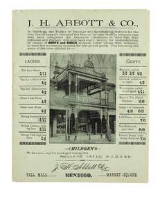
Flyer, Bolton Brothers Printers, J.H. Abbott & Co, c 1880
In 1867 J.H. Abbott established the New Times Boot Market & Factory in Pall Mall, Sandhurst. In 1867, his wife Anne took over running the shop which was located next to the Bendigo Arcade near Williamson Street and was successful in creating a successful business. In 1876, the leather business of T. Baulderstone was purchased, and operations were further expanded later by the acquisition of the Edinburgh Tannery at Sheepwash Creek, and The Edinburgh Leather & Grindery warehouse in Bull Street, Sandhurst. In 1889, Joseph Abbott passed all interests in the business to his son, who shared the same name, in partnership with an adopted son, Richard Hartley Smith Abbott. The business continued trading under the name J. H. Abbott & Co. A number of branches of the business had been established in the early 1900s. In 1959 the Pall Mall business relocated to 291 Hargreaves Street. The whole business was soon after consolidated and conducted from the Market Square branch (Lyttleton Terrace) as the Abbott Supply Company. Harold Abbott, the last of the family to work in the business, died in 1979. In 1980 the business shifted to a new purpose-built store and warehouse on the corner of Abel & Deborah Streets, Bendigo. Sandhurst Trustees administered the business from 1979 until its sale in 1986. He was elected to the Sandhurst Borough Council and in 1860 became chairman of the municipality.Two single colour printed gatefold flyer on green paper advertising J.H. Abbott and Co.'s boot and shoe store on Pall Mall Bendigo. Contains information on products and the fitting services provided in store for customers. chairman of sandhurst borough, anne abbott, city of greater bendigo commerce -
 Bendigo Historical Society Inc.
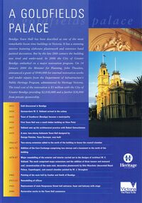
Document - BENDIGO TOWN HALL ''A GOLDFIELD' PALACE'' LEAFLET, 2002
Bendigo Town Hall, Heritage Victoria ''A Goldfields Palace Blue Leaflet'' with coloured photographs and white text. Photographs courtesy of Westox Pty Ltd and the City of Greater Bendigo. 2002. Front page features the extensive work that would be undertaken for the restoration. A time line beginning 1851, gold discovered in Bendigo. 1854 German-born W. C. Vahland arrived in the colony. 1855 Town of Sandhurst (Bendigo) became a municipality. 1856 First Town Hall was a small timber building on View point. 1857 Vahland sets up his architectural practice with Robert Getzschmann. 1859 A new, two-storey Italianate Town hall designed by George Fletcher, Town Surveyor, was built. 1866-77 Two-storey extension added to the north of the building to house the council chamber. 1871-72 Addition of the Corn Exchange comprising two storeys and a basement to the north of the building. 1878-87 Major remodelling of the exterior and interior carried out to the designs of architect W. C. Vahland. The work comprised major extensions and the addition of three towers and mansard roof, reconstruction of the main stair, decorative plasterwork by Otto Waschatz (decorated Royal palace, Copenhagen), and council chamber painted by W. J. Straugher. 1902 Painting of the main hall by Coulter and Smith of Bendigo. 1913-15 Remodelling of offices. 1926 Replacement of main Hargreaves Street hall entrance, foyer and balcony with stage. 2000 Restoration works to the Town hall commence. The middle pages and the back show some of the conservation works that were required.bendigo, tourism, town hall restoration, 4-2000 www.heritage.vic.gov.au -
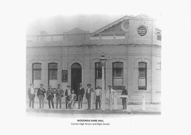 Wodonga & District Historical Society Inc
Photograph - Wodonga Civic Buildings Over Time
Wodonga Shire was created in 1876 when the colonial government agreed to ratepayers' petitions to have their part of the local government district severed from the Yackandandah Shire to form a new municipality. After meeting for 14 years in rented remises, in the Prince of Wales Hall, Wodonga Council built its first Shire Hall on the corner of High and Elgin Streets in 1890. The date on the façade of the building, 1876, represents the date of the formation of the Shire. In 1957 the second Shire Office was built in Woodland Grove by A.B. and M. A. Chick. These offices were considered more than adequate for future needs. The façade featured floor to ceiling windows and several different meeting rooms in addition to the council chamber, which featured an impressive “horse shoe” table. It also included a kitchen equipped with modern fittings and a President’s room. In the late 1960s the area between Hovell and Havelock Streets as far as Jack Hore Place was zoned for civic purposes. In 1969 plans for a civic centre providing a library, theatre and senior citizens’ rooms. It was opened on 22 April 1971. In 1973, the Council engaged Bruce Marshall to design new offices beside the Civic Centre. Jennings Industries were contracted to complete the offices. The Governor, Sir Henry Winneke, laid the foundation stone of the new offices on 10 March 1976. The Civic Centre was demolished in 2011 to make may for a new $10 million community and entertainment centre which opened in August 2012.These photos are significant because they depict the different buildings which have housed the centre of local government in Wodonga since its inception as an independent shire in 1876.A series of photographs depicting the different buildings used to house the Wodonga Council and Civic buildings over time.wodonga civic buildings, wodonga council, shire of wodonga, rural city of wodonga -
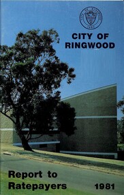 Ringwood and District Historical Society
Booklet, Champion Press, City of Ringwood Report to Ratepayers 1981, 1981
Community booklet issued by City of Ringwood for 1981 - covering the facilities and activities of the Ringwood Council and other local organisations and associations. CONTENTS: (page number) Beautification and Leisure Areas 24 Building — General Information 21 Commissioners for Taking Declarations and Affidavits 15 Council Finance 11 Council Meeting Dates 5 Council Representation on various organisations 8 Councillors 6 Elections for Council 10 Emergency Telephone Numbers 51 Health -30 Home Help Service 22 Immunisation Programme 31 Infant Welfare Centres 33 Items of Interest 16 Justices of the Peace 14 Let's Be Neighbourly 20 Library — General 18 Library — Service for our Senior Citizens 23 Major Works 12 Map of municipality 26 Mayor's Message - Cr. F.J. Corr 4 Meals on Wheels 28 Members of Parliament 50 Officers of the Council 9 Proposed Leisure Centre 14 Rate Assistance 11 Rate Payments 10 Recycling Depots 49 Ringwood Cultural Centre 2 Ringwood Festival activities for 1981 29 Standing Committees of Council 5 Swimming Centre 13 Welfare and Community Services 34 rinx -
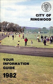 Ringwood and District Historical Society
Booklet, City of Ringwood - Your Information Guide 1982, 1982
Community information booklet issued by City of Ringwood for 1982 - covering the facilities and activities of the Ringwood Council and other local organisations and associations. Cover photograph: A.C. Robertson Athletic Field. CONTENTS: (page no.) Beautification and Leisure Areas 16 Building — General Information 26 By-Laws 27 Circuit Bus — Ringwood City 54 Commissioners for taking Declarations and Affidavits 31 Council Meeting Dates 6 Council Representation 7 Councillors 4 Cultural Centre 32 Disabled Persons - Facilities 34 Elections for Council 10 Emergency Telephone Numbers 54 Festival 33 Finance — Council 12 Golf Course 30 Health Home Help Service 24 Immunisation Programme 20 Items of Interest 22 Justices of the Peace 30 Library — General 13 Library — Service for our Senior Citizens 26 Major Works Programme 14 Map of Municipality 28 Mayor's Message – Cr. N.J. Hamilton 2 Meals on Wheels 25 Members of Parliament 52 Officers of the Council 8 Property Records 10 Rates 11 Recycling Depots S3 Regulations 27 Roll — Municipal 10 Swimming Centre 21 Voting — Compulsory 10 Welfare and Community Services 35 rinx -
 St Kilda Historical Society
Photograph, St Kilda Municipal Depot, Inkerman Street - images collection, 1979
Prior to its demolition in 1979, the St Kilda Municipal Depot occupied a 1.2 hectare site at 33 Inkerman Street St Kilda. The land was initially purchased by the Council in 1867 as a site for a permanent market, which ceased to operate in about 1882. In October 1923, the Council discontinued the practice of disposing garbage by burial in tips when it opened a garbage incinerator at the Depot. After thirty years this incinerator had become both obsolete and objectionable to health and was replaced in March 1953 by American-designed Monohearth Garbage Destructor Units. According to the Council, these Destructor Units were the only ones of their kind in Australia and they removed all the objectionable features of garbage disposal (particularly for the employees). They were expected to serve St. Kilda's requirements for the next 80-100 years. In 1957 the Council said that the Destructor Units had 'enabled substantial economies to be effected in the annual costs and have proved a very successful venture. The Council now destroys the garbage from the City of Brighton, which pays for the privilege, and it is anticipated that other Municipalities will also take advantage of ihe benefits of this modern and, in Australia.' See 'City of St Kilda 1857-1957 A Brief Outline of Progress and Development' [82] In 1994, as a result of the local government amalgamation process combining the former Cities of Port Melbourne, South Melbourne and St.Kilda, the new City of Port Phillip owned three municipal depots. The St. Kilda municipal depot site became surplus to requirements and, in 1996, the City of Port Phillip resolved to use the site for a community housing project under the City of Port Phillip Housing Program. Colour photographCouncil Yards before demolition 1979st kilda, st kilda municipal depot, inkerman street, council depot, destructor -
 Eltham District Historical Society Inc
Photograph, Former Shire of Eltham President, Cr. Mary Grant with the Presidential Chain of Office
Cr. Mary Grant of Hurstbridge served as the North Riding Councillor for the Shire of Eltham. First elected in 1990 and required to retire by 1995. She was the Shire President at least 1992-1993. Source: Shire of Eltham 1993 Handbook. It is believed that this photograph was taken after Cr. Grant's term as President. EDHS Newsletter No. 216, May 2014, p4 Mayoral Chain of Office R.C. McLellan and family donated a Chain of Office to the Shire of Eltham to be worn by the Shire President on formal occasions. With the amalgamation of councils in 1994 this was transferred to the Shire of Nillumbik to be used during the mayoral year. Eltham had a Shire President whereas Nillumbik has a Mayor. Many municipalities have a collar or chain of office for ceremonial purposes. Traditionally these symbolise or denote the formal leadership role of office. This chain is part of the Visual Art Collection held by Nillumbik Shire Council and is now on display in the Council Chamber area in the Civic Centre at Greensborough. Matcham Skipper and Myra Skipper were commissioned by the McClellan family to create the gold-plated silver chain shown being worn by Eltham Shire President Peter Graham in 1990, with Bob McLellan and Matcham Skipper (centre). Nillumbik Shire Council has asked that the following credit information is used when the chain is displayed, or images reproduced. Matcham SKIPPER (1921-2011) and Myra SKIPPER (1920-1996) Mayoral (Presidential) Chains of Office 1976 Gold plated silver 60cm x 32cm x 1cm (variable) © The Estate of Matcham and Myra Skipper Donated by RC McLellan and Family Visual Art Collection: Nillumbik Shire Council [Picture: Nillumbik Mayoral Chain of Office] [Picture: Bob McLellan, Matcham Skipper and Eltham Shire President Peter Graham -1990]The Presidential Chain of Office is now a significant part of the Nillumbik Shire Council's art collection.Colour photograph Councillor Mary Grant in Shire President Regaliacouncillors, eltham shire council, shire presidents, mary grant, nillumbik shire art collection, presidential chain of office -
 Glen Eira Historical Society
Document - History of the City of Caulfield
This file contains 4 items: 1/Typewritten document titled ‘The City of Caulfield’. Author and date unknown. 1 page (back and front), 2 copies. Document covers topics such as origins of the name ‘Caulfield’, early settlement and the Caulfield Cup. 2/Typewritten document titled ‘History of Caulfield Council’. Author and date unknown. 6 pages, 3 copies. Document covers subjects such as early settlement, Aboriginal influence, Caulfield Road Board, Shire of Caulfield, Borough and town boundaries, coat of arms, and Freedom of Entry to the City. 3/Typewritten document (undated + author unknown) titled ‘The Structure of Local Government in Victoria with a history of the City of Caulfield’. 13 pages. Covers the following subjects: Powers, Planning, Public Works, Trading Undertakings, Health Services, Municipalities, Wards Electors or Ratepayers, Voters Roll, Councillors, Officers, Finance, Nature of Soil and Vegetation, Parks and Gardens and Reserves, Coat of Arms, Boundaries, How Did Caulfield get its Name, Aboriginal Influence, Caulfield Road Board, Shire of Caulfield, Borough and Town and the City of Caulfield. Also covered is early settlement. Note at the end of the document mentions that the historical content contained in the last section was based upon a thesis for the Department of Town and Regional Planning, University of Melbourne, 1968 by L. Alwis, P. Rowe, N. Wootten. Melbourne, ‘City of Caulfield: An Illustrated City Report’. 4/Typewritten document (undated) titled ‘The Structure of Local Government in Victoria with notes on the history of the City of Caulfield’. 8 pages, 2 copies. This document also includes a map/diagram of the city with boundaries and wards showing locations of railway stations and parks. Document covers the structure of local government and its functions then goes on to focus on City of Caulfield with subjects similar to those covered in item 3. Document signed off by Deputy Town Clerk.city of caulfield, caulfield john, caulfield baron, caulfield racecourse, elsternwick, ripponlea, st. mary’s church, caulfield council, kooyong road, neerim road, bambra road, greenmeadows house, caulfield park, paddy’s swamp, dandenong road, caulfield grammar school, chisholm institute of technology, murrumbeena, glen eira road, alma road, orrong road, balaclava road, inkerman road, ‘grosmont’, caulfield school room, caulfield road board, caulfield road district, crimean war, victorian amateur turf club, caulfield cup, glenhuntly road, north road, glenhuntly station, ormond station, outer circle railway, local government, gardenvale, carnegie, rosstown, poath road, nepean highway, hotham street, ormond park, princes park, ross william murray, caulfield institute of technology, ‘ross’ folly’, hawthorn road, glenhuntly, ormond, morris t. w., lloyd charles du plan, meals on wheels, shire of caulfield, caulfield railway station, caulfield rsl, bouran road, murrum murrumbeen, kooyong road, great dandenong road, neerim road, trams, prahran and malvern tramways trust, fisher andrew, mackinnon reserve, dover street, ‘glen eira’, blair max cr., insignia, third ordnance services unit, schools, street lighting, lampriere, mr. bevan, the caulfield leader, davies j. henry, curraweena road, st. georges road, o’neill college, hope george, market gardens, koornang reserve, packer reserve, murrumbeena reserve, hopetoun gardens, greenmeadows gardens, mirambeena, caulfield technical college, hart john, langdon h. j., ‘rosecraddock’, judge webb, ‘crotonhurst’, service james, ‘kilwinning’, ricketson henry, grimwade frederick sheppard, airdrie, jenner, st. aubin’s, caulfield john p. t., harlston, lempriere, lord reserve, ‘cantala’ -
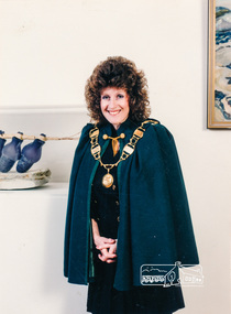
 Bendigo Historical Society Inc.
Document - DRAFT ARTICLES FOR RHSV (BENDIGO) NEWSLETTER, MAY 1972
Draft articles for RHSV (Bendigo) Newsletter, May 1972. 1. ''Golden Square Methodist Church'' by Lydia Chancellor - memories of church services, Sunday School and Bible classes. Mention of (Minister?) Mr Robert Saunders. Also - Rev B W Heath; Mr Crump, Rev Henry Worrall; reference to Jubilee of church in 1923. 2. Article submitted by Mrs E M Checcucci re the 'White Works' (clothing factory making underwear at the top of Wattle Street) - visited by Prince of Wales in 1920; 3. Handwritten and typewritten version of ''Extracts from the 'Sandhurst Library Almanac 1858', published by P M Sparkes, Bookseller and Stationer (four doors from Shamrock Hotel). Names listed of officers of the 40th Foot (Captain's detachment); Location of two cemeteries; Municipal Council of 1858 - Chairman and councillors and meeting times and place; Police Department - names listed of officers of department, Sandhurst Municipality, 'The District' and Eaglehawk Township (names for the last being only on the handwritten copy); 4. Article (w Perry) ''Australian Aboriginals on the Bendigo Gold Field’’ reference to ''King Charlie'' and finding of gold by him (reference to this in the Bendigo Advertiser 1856 & 1857). The gold purchased by a Mr Bannerman; 5. Article on introduction of gas in Bendigo (by I Hendry). Ref to ''Spotlight'' article in Advertiser of Oct 13, 1950. Mention of Mr Dondy (first user of gas in Bendigo); early use and price of gar; poor gas pressure in Eaglehawk; 6. Handwritten article submitted by John O'C Hattam re 'Indian Hawkers in Bendigo': with request to members to join him in further researching this interesting project; mention of accommodation in Hopetoun Street in terrace houses of the same design as Specimen Cottage (''now occupied by ' Glover??? Mills - but referred to in printed Newsletter of April/May 1972 as ''a site occupied by a clothing factory''); mention of hawkers by name - Rajah Singh, Mahonett Betth, Mahonett Shang, Rajah Bouth, Mahoety Bux, Abdul Rahman (last hawker)document, names of bendigo pioneers, bendigo advertiser -
Federation University Historical Collection
Pamphlet, Jeff Zilles, Old Curiosity Shop, c1980s
The Old Curiosity Shop was q house was built by bricklayer James Warwick, and his wife Caroline, with construction beginning around 1863. It was opened to the public in 1895. What is significant? Construction of the house later known as the Old Curiosity Shop commenced about 1863, the year bricklayer, James Warwick obtained a miner's right for a residential block on the edge of the exhausted Eureka diggings in the newly proclaimed municipality of Ballarat East. James built a modest 4-roomed timber and brick house for his expanding family and continued in the bricklaying trade until retiring around the early 1880s. By then he was pursuing his gardening interests in the local Horticultural Society and was supervising the gardens of many East Ballarat residents. It was during these years that his gardening and building interests converged to find expression in the marvellous permutations of decoration that extend over the house and garden. Using cast-off crockery, glass, ceramic figurine and mirror shards, shells, wallpaper samples, architectural ornament and slag, a place was found for all manner of things, large and small. Children would bring broken china dolls and bits of crockery, and the patient mosaic work preoccupied James and his wife Caroline for the rest of their lives. The work has its origins in the grottoes and shellhouses that ornamented the gardens of large English estates from the 1730s. In the few years before James' death in 1898, the house had become known as the 'Old Curiosity Shop', inspiring associations with the Charles Dickens novel of the same name. By then professional photographs had also been taken and thousands of tourists were visiting it yearly. Caroline obtained copyright for 2 of the photos and began issuing her own postcards before she died in 1903. The Shop passed to their son Charles and then to a succession of owners who added their own mythology to the story of the Warwicks and their work. After attracting tourists for more than 100 years, the Shop closed to the public in 1999. (Vitorian Heritage Database)Brochures on the Old Curiosity Shopold curiosity shop, warwick, ballarat east, james warwick, caroline warwick -
 Glen Eira City Council History and Heritage Collection
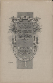
Booklet, "AVENUES OF HONOUR The Councils of the Municipalities of the CITY OF CAULFIELD TOWN OF BRIGHTON acting in conjunction PUBLIC DEMONSTRATION SAT 3rd AUG. 1918 AT 3oCLOCK"
Souvenir Programme from the Councils of the Municipalities of the City of Caulfield and the Town of Brighton for a Public Demonstration to be held on Sat 3rd August 1918 at 3 o'clock for the proposed Avenues of Honour to be planted in memory of fallen WWI soldiers. From Honour Roll Display 2019 interpretation panel - Brighton-Caulfield Avenue of Honour It is hard to imagine but a grand arboreal Avenue of Honour once lined parts of North Road, McMillan Street and Point Nepean Road (now Nepean Highway). The Avenue of Honour was a distinctly Australian phenomenon with hundreds being constructed throughout Australia during and following World War One, most of these in Victoria. Consisting of tree lined streets with each tree representing a solider, the Avenue of Honour signalled a more egalitarian approach to commemoration where rank was not a consideration. Arguably the most famous Avenue of Honour in Victoria still exists at Ballarat. Stretching for nearly 22 kilometres, the entrance to the Avenue is marked by the imposing Arch of Victory. Smaller in scale, the Brighton-Caulfield Avenue of Honour was dedicated to the ‘memory of (Brighton and Caulfield’s) kith and kin who came from (the) district and who died in the Great War’. A joint project between the neighbouring Councils, the idea was first reported in The Argus on 1 July 1918. Plans moved along quickly and on 3 August 1918 the Governor of Victoria Arthur Stanley planted the first Australian flowering gum. The next of kin were then invited to plant trees for lost sons, brothers, uncles, nephews and husbands. In all, over 400 trees were planted. Intensely personal, the Avenue also acted as a focus of grief and remembrance for the wider community. For many years, the annual civic Anzac Day service was held at the Avenue on Point Nepean Road, near Glen Huntly Road, Elsternwick. The service was moved to Caulfield Park upon the completion of the Cenotaph in 1930. Due to road widening and disease the last original tree was replaced in the 1980s, however a plaque in Caulfield Park records the Avenue’s plantation. Commemorative booklet, grey cover with text printed on the grey textured paper cover and an image of four trees and a wreath. Image of a kookaburra on the back. Inside, 28 numbered pages with b/w text and photographic images including a transparent paper representation of the proposed Avenues of Honour on Brighton Road and Point Nepean Road. Souvenir programme for a Public Demonstration for the Avenues of Honour as detailed on the front.city of caufield, world war one, first world war, anzac, remembrance, town of brighton, brighton, caulfield, avenue of honour -
 Melton City Libraries
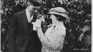
Photograph, Tom Barrie, Unknown
Son of Jessie and Charles Ernest Barrie of Darlingsford Melton Married Marion Ferris at Christ Church Melton on 11th May 1939. They lived on the family farm at Ferris Road Melton. They had one son, Ian who has continued in farming in Melton. He served the community in the following – Shire of Melton Councillor Member for 32 years 1941 – 1970 Elected as Councillor for Melton South 1970 – 1973 Councillor for Rockbank 1943 – 1944 Shire President for three terms 1958 – 1959 ditto 1964 – 1965 ditto Council Representative: Bacchus Marsh High School and Western Suburbs Municipalities. Representative on delegation to prevent Melton post primary students being sent to Deer Park prior to the establishment of Melton High School. Melton Bush Fire Brigade 1941 Member Melton Bush Fire Brigade Registered No. 425 1942 1942 2nd Lieutenant 1943 – 1944 4th Lieutenant Country Fire Authority Rural Services Award 1963 20 Years Long Service Badge Scots Presbyterian Church Melton Member of the Board of Management 1947 – 1969 information from Annual Reports Tom farmed the family property with his father and brothers, and later the Ferris Road property which continued with his son Ian. His childhood interest in horses began with the draft horses kept at the bluestone stable and barn at Darlingsford. When the stables were empty in the late 1980s visit, he vividly recalled the names of the horses he had handled in his youth. When the draft horse became obsolete with the introduction of tractors and trucks this interest continued with the breeding and training of harness racers. Darlingsford Drafts and Ponies. Order of Stalls Clydesdales – Dick, Dolly, Flower, Nugget, Blossom, Lofty, Prince. Roger, Rose, Violet, Don, Beauty, Baldy, Diamond. Cart and Mounts Creamy, Digger, Popsy Black and white photographs of Tom Barrielocal identities -
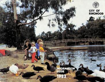 Ringwood and District Historical Society
Booklet, City of Ringwood Information Guide 1983, 1983
Community information booklet issued by City of Ringwood for 1983 - covering the facilities and activities of the Ringwood Council and other local organisations and associations. Cover photograph: Ringwood Lake Reserve.CONTENTS: (page no.) Aged — Centre for the Frail Aged 22 Building — General Information 28 By-Laws and Regulations 27 Circuit Bus — Ringwood City 33 Commissioners for taking Declarations and Affidavits 29 Committees of Council 6 Council Meeting Dates 6 Council Officers 8 Council Representation 7 Councillors 4 Cultural Centre 36 Disabled Persons - Facilities 21 Emergency Telephone Numbers 58 Elections for Council 10 Festival 23 Finance - Council 11 Garbage Collection 58 Golf Course 37 Health 18 Home Help 25 Immunisation Programme 20 Immunisation Schedule 19 Items of Interest 32 Justices of the Peace 29 Lake — Ringwood Lake Reserve 59 Leisure Areas 16 Library — General 12 Library - Service for our Senior Citizens 26 Major Works Programme 14 Map of Municipality 30 Mayor’s Message – Cr. Pat Gotlib, J.P. 2 Meals on Wheels 24 Members of Parliament 56 Nature Strip Maintenance 34 Pensioners — Rate Assistance 11 Rates 10 Recycling of Waste 57 Roll — Municipal 10 Shuttle Bus 33 Swimming Centre 37 Voting — Compulsory 10 Welfare and Community Services 38 rinx -
 Melton City Libraries
Photograph, Opening of the Shire Hall, c.1964
Summary of Thomas Lindsay Barrie (1914 – 1990) A life long resident of Melton Son of Jessie and Charles Ernest Barrie of Darlingsford Melton Married Marion Ferris at Christ Church Melton on 11th May 1939. They lived on the family farm at Ferris Road Melton. They had one son, Ian who has continued in farming in Melton. He served the community in the following – Shire of Melton Councillor Member for 32 years 1941 – 1970 Elected as Councillor for Melton South 1970 – 1973 Councillor for Rockbank 1943 – 1944 Shire President for three terms 1958 – 1959 ditto 1964 – 1965 ditto Council Representative: Bacchus Marsh High School and Western Suburbs Municipalities. Representative on delegation to prevent Melton post primary students being sent to Deer Park prior to the establishment of Melton High School. Melton Bush Fire Brigade 1941 Member Melton Bush Fire Brigade Registered No. 425 1942 1942 2nd Lieutenant 1943 – 1944 4th Lieutenant Country Fire Authority Rural Services Award 1963 20 Years Long Service Badge Scots Presbyterian Church Melton Member of the Board of Management 1947 – 1969 information from Annual Reports note more research needed at Uniting Church Archives to determine the earliest and last date. Tom farmed the family property with his father and brothers, and later the Ferris Road property which continued with his son Ian. His childhood interest in horses began with the draft horses kept at the bluestone stable and barn at Darlingsford. When the stables were empty in the late 1980s visit, he vividly recalled the names of the horses he had handled in his youth. When the draft horse became obsolete with the introduction of tractors and trucks this interest continued with the breeding and training of harness racers. Darlingsford Drafts and Ponies. Order of Stalls Clydesdales – Dick, Dolly, Flower, Nugget, Blossom, Lofty, Prince. Roger, Rose, Violet, Don, Beauty, Baldy, Diamond. Cart and Mounts Creamy, Digger, Popsy Compiled by Wendy Barrie 2013 Councillor Tom Barrie, Shire President and a group of children at the opening of the building.council, local identities -
 Surrey Hills Historical Society Collection
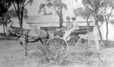
Photograph, 'Hillsboro' or "Hillsborough' - 6a Thistle Street, Surrey Hills, pre-1890
The photo was found behind a mantelpiece in the house at 6A Thistle Street while it was being renovated. It is thought to be of the first owner, Mrs Rachel Sweetnam (nee Lewis) and her husband, Thomas Edward Sweetnam. They were married on 24 September 1884 at St John's Church, Camberwell. REF: THE ARGUS 4 Oct 1884 Thomas second eldest surviving son of Matthew Sweetnam married to Rachel (Ray) third eldest daughter of Captain T.D. Lewis, Culm Haven, Camberwell. Thomas was active in land sales and variously described as a land agent, real estate agent and auctioneer. The property - Hillsboro or Hillsborough - was originally a house on a farm of 10 acres owned by her. It became 6A Thistle Street. According to the Alan Holt property register Rachel Sweetnam owned the property prior to 1890 and a family tree on Ancestry.com has that it was owned by her in c1886. It is likely that it was an investment rather than a family residence. Thomas Sweetnam was President of the Boroondara Shire 1888/89 and a councillor from 1886-1891. During his time as Shire councillor in 1887 he was charged with assaulting Charles A. Chandler, a window blind manufacturer, in response to an ‘insulting note’ left at Sweetnam’s house. Sweetnam was fined two guineas and 31 shillings. Sweetnam was also President of the Camberwell Gun Club from around 1890 – 91. In 1893 he relocated to Ferntree Gully, where he contested for the municipality’s North Riding council seat. Multiple references can be found on Trove. Note that the gentleman in this photo does bear a resemblance to Thomas Sweetman, President of Boroondara Shire in 1888-1889 found in the City of Boroondara Library Service mayoral portrait collection. No known photo of Rachel Sweetnam. Other property owners or residents are: 1890 Selina Gaylor 1900 Stephen Pullen 1910 William Murray (draftsman) 1920 George C Hughes 1930 Arthur Leslie Austin (tram driver) 1980 Mrs Lillian Evelyn Austin Sold in 1983 for $87,000. The house is still extant (January 2025). Note that we also have material / photos regarding George Hughes and family.This photo is one of the earliest photos of residences of Surrey Hills.Black and white photo of a woman and man in a buggy behind which is a simple house with a verandah at one end, surrounded by eucalypt trees.hillsboro, house names, thistle street, horse-drawn vehicle, clothing and dress, hillsborough, rachel sweetnam, rachel lewis, thomas sweetnam, selina gaylor, stephen pullen, william murray, george hughes, arthur austin, lillian austin -
 Sunshine and District Historical Society Incorporated
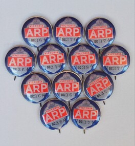
Air Raid Precautions (ARP) badges, Circa early 1940's
Mr Webb King was an Air Raid Warden during World War 2. These badges were found when his workshop was being cleared out, and so were donated to our society. The badges in our possession do not have the word WARDEN printed on them, like the image of the badge shown on the Darebin Heritage 'Air Raid Protection Services (ARP)' publication, or the image of a badge offered for sale on ebay. At this stage we are uncertain of why this is so. If anybody knows the answer then please leave a message on this site. During World War 2 Australian municipalities were expected to take precautions against air raids, with the Government campaigning to recruit men over 45 to be volunteer Air Raid Wardens. It was also common for women to become wardens. Wardens carried gas masks, helmets, and rattles or whistles. The wardens received 7 to 8 one hour sessions of training, and their chief duty was to advise people of precautions to take, and to ensure those precautions were taken. Air Raid Precautions included air raid drills, shelters (usually trenches), first aid, fire fighting, rescue of 'gassed' persons, evacuation drills, demolition and repair squads, monitoring of blackouts. Melbourne was deemed vulnerable to aerial attack because of its centralised port and industrial facilities and so Anti-aircraft guns were installed in Maribyrnong. By early 1942 more than 60,000 people voluntarily carried out Air Raid Precautions duties according to the Autobiography of Robert V. J. Padula OAM. As the threat diminished during 1943 and 1944 the need for air raid precautions was slowly reduced, and some shelters (trenches) were filled. The two photos showing Air Raid Wardens are out of copyright and have been sourced from the 'Argus Newspaper Collection of Photographs, State Library of Victoria.' The image showing one warden on Swanston Street Melbourne has been cropped to remove extras not connected with the photo. Other sources of information for this report are: (1) http://bpadula.tripod.com/autobiography/id100.html, (2) https://www.awm.gov.au/exhibitions/underattack/mobilise/precautions.asp, (3) http://heritage.darebinlibraries.vic.gov.au/article/57. The ARP badges are a historic reminder of the precautions that were taken in Victoria during the early years of World War 2. The precautions were an effort to minimise the harmful effects of a theoretical air raid. The war started to turn and so an air raid never came, however many people received valuable training in what precautions needed to be taken.Pressed metal round badges with pins. Main feature of badges is the large whitish lettering ARP on a red background. A black outlined crown and the word VICTORIA in red on whitish background is also on the badges. At the bottom of the badges in black are the letters DC plus the numbers of the badges.Serial Numbers of the badges are: DC 361, DC 362, DC 364, DC 368, DC 370, DC 374, DC 375, DC 376, DC 377, DC 379, DC 388, DC 389.arp. arp badge, air raid precautions, air raid precautions warden, warden, badges -
 Glen Eira Historical Society
Album - Album page, Kambrook Road, Circa 1972
This page of photographs is part of the Caulfield Historical Album 1972. This album was created in approximately 1972 as part of a project by the Caulfield Historical Society to assist in identifying buildings worthy of preservation. The album is related to a Survey the Caulfield Historical Society developed in collaboration with the National Trust of Australia (Victoria) and Caulfield City Council to identify historic buildings within the City of Caulfield that warranted the protection of a National Trust Classification. Principal photographer thought to be Trevor Hart, member of Caulfield Historical Society. Most photographs were taken between 1966-1972 with a small number of photographs being older and from unknown sources. All photographs are black and white except where stated, with 386 photographs over 198 pages. First 2 images: milkbar and residence corner Kambrook and Balaclava Roads ie south west corner - building named Airdrie 3rd image: https://vhd.heritagecouncil.vic.gov.au/places/43737 - re 26 Kambrook Road and 345 Balaclava Road corner building ie south east corner: A prominently situated two-storeyed complex of late Victorian buildings consisting of "Wybar's Buildings" occupying the Balaclava Road/ Kambrook Road corner and the "Caulfield Bakery" facing Kambrook Road, separated by a driveway from a single storeyed shop. The main building has a comer splay and balustraded parapet with curved pediments, the words "Wybar's Buildings 1887" having been obliterated but "Caulfield Bakery 1887" with the characteristic wheatsheaf surviving in raised cement work. The walls are stuccoed and richly ornamented with bracketed cornices and keystones with masks extending to the Bakery. The main building is further distinguished by the Masonic symbol of the mason's dividers in the pediment whilst the upper level of the bakery is in overpainted brickwork. The single storeyed shop incorporates the bracketed cornice and consoles characteristic of the main buildings and is in other respects a utilitarian structure. 4th image: https://vhd.heritagecouncil.vic.gov.au/places/42415 (on 24/01/2021) - 196 Kambrook Road An imposing late Victorian poly-chrome brick asymmetrical villa with corner verandah and projecting west facing wing with faceted window bay to the facade. Body bricks are red and relieved by cream and black brick banding and by cream bricks to the bracketed eaves. The fretted barge with king post treatment and timber posted verandah are unique in the Municipality and unusual in the metropolitan area and demonstrate an understated appreciation of the emerging Queen Anne mode.345 Balaclava and 26 Kambrook Roads HO91 - City of Glen Eira https://vhd.heritagecouncil.vic.gov.au/places/43737 (on 24/01/2021) "Wybar's Buildings" at the corner of Balaclava Road and Kambrook Road are important as a prominent late Victorian commercial development incorporating a variety of activities including a bakery and possibly a coffee palace, the latter understood to be unique within the municipality, but characteristic of the period. It is a rare complex of its type in Caulfield and is important also as evocative evidence of the late Victorian Land Boom and the creation of a small now defunct commercial centre at this location by the George Wybrow. 196 Kambrook Road HO122 - City of Glen Eira https://vhd.heritagecouncil.vic.gov.au/places/42415 "Glencoe" is situated at no. 196 Kambrook Road, Caulfield North and was built for the boot manufacturer, Robert Bruce Mair, in 1888. It is of historic and aesthetic significance. It is historically significant (Criterion A) as the home of an inner suburban industrialist, notable a boot manufacturer, demonstrating the attraction of Caulfield as a residential location for the manufacturers of the metropolis during the late Victorian Boom period. It is aesthetically significant (Criterion E) as a very early example of a Queen Anne influenced late Victorian villa, comparing at the State level with ''Woodlands'' (1888), North Essendon, generally acknowledged to be one of Australia's earliest houses to fully exploit this emerging style. The ornamental timberwork is especially expressive of the new architectural fashion and compares with the house at 33 Clarence Street, Elsternwick (1888-89).Page 105 of Photograph Album with two photographs of a milk bar and attached residence, one older photograph of Wybar's Building and another photograph of a house on Kambrook Road (all are landscape).Handwritten: 196 KAMBROOK ROAD / 1970 - GAFFNEY MRS S.M. [under bottom right photo] / 100 [bottom left]trevor hart, kambrook road, victorian style, caulfield north, parapets, wybar's buildings 1887, caulfield bakery 1887, architectural features, painted bricks, balaclava road, george wybrow, shops, milk bars, airdrie, polychrome bricks, verandahs, queen anne architectural style, houses, glencoe, robert mair -
 City of Moorabbin Historical Society (Operating the Box Cottage Museum)
Functional object - Kitchen Equipment, Coolgardie Safe, c1900
The invention of the Coolgardie Safe is credited to Arthur Patrick McCormick, a contractor in Coolgardie, and later the Mayor of Narrogin. Coolgardie is in the Eastern Goldfields region of Western Australia. Gold was first discovered there in 1892; the townsite became a municipality in 1894, and by 1898 its population of 15,000 made it the third largest town in Western Australia after Perth and Fremantle. In the last decade of the 19th century, Coolgardie was the capital of the West Australian goldfields. Being 180 kilometres from the nearest civilisation, food supplies were initially scarce and expensive. As fresh food was a valuable commodity there was incentive to preserve it, and keep it out of reach of scavengers such as birds, dingos, dogs, ants, and flies. It was in an effort to do this, in the extreme heat of the Australian Interior, that McCormick came up with his design for the Coolgardie Safe. McCormick noticed that a wet bag placed over a bottle cooled its contents. He further noted that if this bottle was placed in a breeze, the bag would dry out more quickly, but the bottle would get colder. What McCormick had discovered was the principle of evaporation: ‘to change any liquid into a gaseous state requires energy. This energy is taken in the form of heat from its surroundings.’ Employing this principle, McCormick made a box for his provisions which he covered with a wet hessian bag. He then placed a tray on top, into which he poured water twice daily. He hung strips of flannel from the tray so that water would drip down onto the hessian bag, keeping it damp. As the water evaporated, the heat dissipated, keeping the food stored inside cool and fresh. The success of McCormick’s invention would not have worked without a steady supply of water. Fresh water was scarce in the eastern goldfields at this time but the demand for water from a steadily growing population encouraged innovation. The solution was to condense salt water. Heating salt water in tanks produced steam that was condensed in tall cylinders, cooled and then collected in catchment trays. By 1898 there were six companies supplying condensed water to the goldfields, the largest company producing 100,000 gallons of water a day. In the early 20th century, Coolgardie Safes were also manufactured commercially. These safes incorporated shelving and a door, had metal or wooden frames and hessian bodies. The feet of the safe were usually placed in a tray of water to keep ants away. (MAV website) The early settlers of Moorabbin Shire depended on this type of Food Safe to protect their food from flies and vermin as they established market gardens in the fertile area around the notorious Elster Creek A metal framed, 4 sided structure standing on 4 legs with 2 hinged doors on one side, a metal tray at base of food safe and a metal cover over top. Ridges on which to rest trays carrying food are inside safe. The Safe is enclosed by fly-wire mesh.'...IN.....GEELONG' A manufacturer's oval metal plate is embossed on one side of Safe but it is illegible.elster creek, moorabbin, brighton, dendy's special survey 1841, market gardens, infant mortality, disease, cemeteries, fruit, vegetables, pioneers, coolgardie safe, mccormick arthur patrick, dendy henry, vaccination, jones martha, jones ethel may -
 Melton City Libraries
Photograph, Tom and May Barrie, 1935
Ferris Road–Ferris Lane family farm of John and Elizabeth Ferris until 1939, until daughter Marion married Thomas Linsday Barrie. Marion Elizabeth nee Ferris born 29th of August 1914 -died 5th of June 1990 SUMMARY - Thomas Lindsay Barrie 1914 – 1990 A life long resident of Melton Son of Jessie and Charles Ernest Barrie of Darlingsford Melton Married Marion Ferris at Christ Church Melton on 11th May 1939. They lived on the family farm at Ferris Road Melton. They had one son, Ian who has continued in farming in Melton. He served the community in the following – Shire of Melton Councillor Member for 32 years 1941 – 1970 Elected as Councillor for Melton South 1970 – 1973 Councillor for Rockbank 1943 – 1944 Shire President for three terms 1958 – 1959 ditto 1964 – 1965 ditto Council Representative: Bacchus Marsh High School and Western Suburbs Municipalities. Representative on delegation to prevent Melton post primary students being sent to Deer Park prior to the establishment of Melton High School. Melton Bush Fire Brigade 1941 Member Melton Bush Fire Brigade Registered No. 425 1942 1942 2nd Lieutenant 1943 – 1944 4th Lieutenant Country Fire Authority Rural Services Award 1963 20 Years Long Service Badge Scots Presbyterian Church Melton Member of the Board of Management 1947 – 1969 information from Annual Reports note more research needed at Uniting Church Archives Tom farmed the family property with his father and brothers, and later the Ferris Road property which continued with his son Ian. His childhood interest in horses began with the draft horses kept at the bluestone stable and barn at Darlingsford. When the stables were empty in the late 1980s visit, he vividly recalled the names of the horses he had handled in his youth. When the draft horse became obsolete with the introduction of tractors and trucks this interest continued with the breeding and training of harness racers. Darlingsford Drafts and Ponies. Order of Stalls Clydesdales – Dick, Dolly, Flower, Nugget, Blossom, Lofty, Prince. Roger, Rose, Violet, Don, Beauty, Baldy, Diamond. Cart and Mounts Creamy, Digger, Popsy Couple at Francis McGregor Barrie and Linda Willaton's wedding at Sunshine Methodist Church 20th April 1935?local identities -
 Eltham District Historical Society Inc
Photograph - Digital Photograph, Alan King, Nillumbik Shire Offices, Greensborough, 30 March 2008
Nillumbik Shire Council transferred to the former Diamond Valley Shire Offices in Greensborough after municipal restructuing. The offices became the official Nillumbik Shire Council Offices on 16 October 1995. The former Shire of Diamond Valley Civic Centre or Shire Office building was officially opened on 26th February 1972. Archtiects were A.K. Lines, McFarlane & Marshall and it was built by L.U. Simon Pty Ltd, The Diamond Valley Shire had been created in 1964 from part of the City of Heidelberg. On December 15, 1994 the Shire of Nillumbik was established. Under the Council amalgamations imposed by the Kennett government, the Shire of Eltham, Shire of Diamond Valley and City of Heidelberg ceased to exist with the establishment of Nillumbik Shire Council and the City of Banyule.The new Nillumbik shire surrended the west riding from Eltham to Banyule but in place gained parts of the former Diamond Valley Shire which itself had been created in 1964 from parts of the City of Heidelberg. Three unelected and non-local Commissioners were put in place by the government bringing democracy into question by many members of the local community. The Commissioners determined to abandon the former Shire of Eltham offices located in Main Road, Eltham and in turn occupy the former Shire of Diamond Valley offices located at the boundary of the new shire with Banyule, in Civic Drive, Greensborough. In July 1996 the Commissioners sold the former Eltham Shire Offices and had them bulldozed leading to many years of communiity protest over the process and future development applications. The site has remained vacant ever since. Published: Nillumbik Now and Then / Marguerite Marshall 2008; photographs Alan King with Marguerite Marshall.; p43 It was the need for roads that led to this district’s first council. In 1853 a committee was formed to improve the rough roads, some in Kangaroo Ground being almost impassable in winter.1 The committee fundraised by voluntary levies and grants to improve in particular, the main road between Kangaroo Ground and the Plenty River. From this committee arose the Eltham District Road Board, in 1856, which was the precursor to the Eltham Shire Council. The Board’s first chairman was Kangaroo Ground farmer, John Barr. Secretary was the former committee’s secretary, Andrew Ross, Kangaroo Ground’s first school teacher, and founder of the district newspaper, The Evelyn Observer.2 Most of the board’s income came from a toll-house north of the Lower Plenty Bridge, which funded such projects as a road from Kangaroo Ground to the Caledonia Diggings. In 1871 the Shire of Eltham was proclaimed, with its boundaries the same as those of the Road Board, and Councillor A Donaldson of Kangaroo Ground was the first president. Eltham was at the southern tip of the shire, which extended north to Kinglake and east beyond Yarra Glen. In 1878, part of Kinglake was added to the shire, while the area east of Watts River, near Healesville was removed. In 1912, then again in 1958, the shire was further reduced. Yarra Glen, Steels Creek, Tarrawarra, parts of Healesville and Christmas Hills, were transferred to the Shire of Healesville. In 1972 a smaller area, at Kinglake, was transferred to the Shire of Yea, leaving 277 square kilometres in the Eltham Shire. Perhaps no other Victorian municipality has had so many meeting places. Although from 1858 to 1904, the council convened at the office in the home of Secretary Charles Wingrove, the board, and later the council, also met at other more central locations.3 The board moved from the Fountain of Friendship Hotel to the Eltham Courthouse, to the Kangaroo Ground schoolhouse. It then met at the Kangaroo Ground Hotel, which some considered put it in danger of interruptions by people ‘the worse for liquor’.4 In 1885 the council met at the hall on Mr J Donaldson’s land at Kangaroo Ground. After Wingrove’s retirement, the council rented space at the Kangaroo Ground General Store and Post Office. Then, in 1917, the council bought the former office of The Evelyn Observer, after its printing works transferred to Hurstbridge. In 1934, fire destroyed the shire office, which was temporarily relocated to the Kangaroo Ground home of Shire Secretary, Mr P J McMahon. In 1941, the shire office moved to a new building (which included a public hall) in Eltham, at the corner of Arthur Street and Main Road, where the Eltham Village Shopping Centre was eventually built. Growth required new offices, which opened in 1965, on the former Shillinglaw property in Main Road.5 In 1994, as part of municipal restructuring under the Jeff Kennett Liberal Government, most of the Eltham Shire formed part of the new Shire of Nillumbik. It joined with the north section of the Diamond Valley Shire and parts of the Healesville and Whittlesea municipalities. The Diamond Valley Shire had been created in 1964, from part of the City of Heidelberg. Turbulence followed Nillumbik Shire’s formation. Under the Commissioners the council transferred to the former Diamond Valley Shire offices in Greensborough, and the Eltham council offices were demolished. In March 1997 the first five-member Nillumbik Council was elected. But, in October 1998, the government suspended the council and appointed an administrator . Early in 1999, shire residents voted to increase councillors to nine: comprising five ward councillors and four shire-wide councillors. Elections were held in March 1999. Then, before the March 2002 elections, nine new wards were created.6 In 2008 these were reduced to seven. Today [2008] the council governs a varied population of more than 60,000 people living in townships and on bush properties in the green wedge.This collection of almost 130 photos about places and people within the Shire of Nillumbik, an urban and rural municipality in Melbourne's north, contributes to an understanding of the history of the Shire. Published in 2008 immediately prior to the Black Saturday bushfires of February 7, 2009, it documents sites that were impacted, and in some cases destroyed by the fires. It includes photographs taken especially for the publication, creating a unique time capsule representing the Shire in the early 21st century. It remains the most recent comprehenesive publication devoted to the Shire's history connecting local residents to the past. nillumbik now and then (marshall-king) collection, greensborough, nillumbik shire council offices, civic drive -
 Kew Historical Society Inc
Plaque, Kew City Hall : Opened by The Hon H.E. Bolte M.L.A. Premier of Victoria 23rd April 1960 : Cr H.H. Ferguson J.P. Mayor, 1960
The Municipality of Kew was proclaimed on 19 December 1860, then upgraded to a Borough (1863), a Town (1910) and finally a City (1921). From 1865, its offices were based in the former Athenaeum Hall in Walpole Street, which, although extended in 1883, inevitably became inadequate. Plans for a new purpose-built Town Hall were first mooted in the late 1880s, but fell prey to six subsequent decades of debate. During that time, many sites were considered and rejected, and several schemes prepared. Finally, in 1945, it was resolved to build a new civic centre as a war memorial. The council acquired Southesk, a mansion on the south-west corner of Cotham Road and Charles Street – first mooted as a possible Town Hall site two decades earlier – and plans for a civic precinct were drawn up by John Scarborough. The project stalled until 1957, when a Town Hall Committee was formed and a new architect appointed: Harold Bartlett of Leith & Bartlett. He also proposed an entire civic precinct, of which a large public hall would constitute Stage One. Designed to accommodate almost any public or official function, the space had had a small stage at one end for intimate theatrical productions, a larger stage at the other (with operable sunken orchestra pit) for musical performances, plus the most up-to-date equipment for live TV transmission. The building, befitting its original intent as a war memorial, was also to include a sculpted monument, for which a separate design competition was held. First prize went to George H Allen (1900-1972), long-time head of the Sculpture Department at RMIT and a former war artist himself (the only one, in fact, to have worked in the medium of sculpture). At the time of the Kew project, Allen was best known for his Cenotaph at the Shrine of Remembrance (1955) and a controversial abstract sculpture at Hume House in William Street (1957). Tenders for the new hall were called and the contract (worth £104,986) was awarded to H F Yuncken. The foundation stone was laid by the Mayor, Cr F C O'Brien, on 1 June 1959. Completion (initially scheduled for October) was delayed by the unavailability of certain materials; it was barely finished in time for the official opening (by Premier Henry Bolte) on 23 April 1960. The war memorial was unveiled two days later (Anzac Day) by Bolte's deputy, the Hon A G Rylah. Fittingly, that year also marked Kew's municipal centenary, and many celebratory events were held in and around the new civic centre in December, including a special council meeting (attended by the Prime Minister), a tree planting ceremony and a youth ball. Source: Survey of Built Heritage in Victoria: Stage Two (Built Heritage Pty Ltd., 2010)Plaque commemorating the opening of a new town hall in KewMetal plaque recording the official opening of the Kew City Hall, 23rd April 1960. This plaque was given to the Kew Historical Society in 1991 by the former City of Kew.Kew City Hall / Opened by / The Hon. H.E. Bolte M.L.A. / Premier of Victoria / 23rd April 1960 / Cr. H.G. Ferguson J.P. - Mayor.kew city hall, foundation stones - kew (vic), sir henry bolte, local government -- kew (vic.) -
 Kew Historical Society Inc
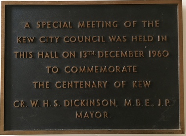
Plaque, A Special Meeting of the Kew City Council Was Held in This Hall on 13th December 1960 to Commemorate the Centenary of Kew : Cr. W.H.S. Dickinson M.B.E., J.P. Mayor, 1960
The Municipality of Kew was proclaimed on 19 December 1860, then upgraded to a Borough (1863), a Town (1910) and finally a City (1921). From 1865, its offices were based in the former Athenaeum Hall in Walpole Street, which, although extended in 1883, inevitably became inadequate. Plans for a new purpose-built Town Hall were first mooted in the late 1880s, but fell prey to six subsequent decades of debate. During that time, many sites were considered and rejected, and several schemes prepared. Finally, in 1945, it was resolved to build a new civic centre as a war memorial. The council acquired Southesk, a mansion on the south-west corner of Cotham Road and Charles Street – first mooted as a possible Town Hall site two decades earlier – and plans for a civic precinct were drawn up by John Scarborough. The project stalled until 1957, when a Town Hall Committee was formed and a new architect appointed: Harold Bartlett of Leith & Bartlett. He also proposed an entire civic precinct, of which a large public hall would constitute Stage One. Designed to accommodate almost any public or official function, the space had had a small stage at one end for intimate theatrical productions, a larger stage at the other (with operable sunken orchestra pit) for musical performances, plus the most up-to-date equipment for live TV transmission. The building, befitting its original intent as a war memorial, was also to include a sculpted monument, for which a separate design competition was held. First prize went to George H Allen (1900-1972), long-time head of the Sculpture Department at RMIT and a former war artist himself (the only one, in fact, to have worked in the medium of sculpture). At the time of the Kew project, Allen was best known for his Cenotaph at the Shrine of Remembrance (1955) and a controversial abstract sculpture at Hume House in William Street (1957). Tenders for the new hall were called and the contract (worth £104,986) was awarded to H F Yuncken. The foundation stone was laid by the Mayor, Cr F C O'Brien, on 1 June 1959. Completion (initially scheduled for October) was delayed by the unavailability of certain materials; it was barely finished in time for the official opening (by Premier Henry Bolte) on 23 April 1960. The war memorial was unveiled two days later (Anzac Day) by Bolte's deputy, the Hon A G Rylah. Fittingly, that year also marked Kew's municipal centenary, and many celebratory events were held in and around the new civic centre in December, including a special council meeting (attended by the Prime Minister), a tree planting ceremony and a youth ball. Source: Survey of Built Heritage in Victoria: Stage Two (Built Heritage Pty Ltd., 2010)Historically significant commemorative plaqueMetal plaque relating to special Council meeting to mark centenary of Kew, 13th December 1960. This plaque was given to the Kew Historical Society in 1991 by the former City of Kew.A Special Meeting Of The / Kew City Council Was Held In / This Hall On 13th December 1960 / To Commemorate / The Centenary of Kew / Cr. W.H.S. Dickinson, M.B.E., J.P., / Mayorkew city hall, foundation stones - kew (vic), cr. w.h.s. dickinson, local government -- kew (vic.) -
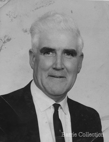
 Flagstaff Hill Maritime Museum and Village
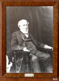
Photograph - Portrait, David Charles McArthur, Superintendent, Bank of Australasia 1867-1876
The subject of this photograph, David Charteris McArthur was the founding manager of the Bank of Australasia in Port Phillip (Melbourne). McArthur was born in 1808 in Gloucester, England, and educated in Scotland. He worked for an insurance firm in Edinburgh where in 1835 he married Caroline nee Wright. McArthur and his family party sailed from the U.K. to arrive in Sydney in October 1835, where he joined the Bank of Australasia when it opened in Sydney in December. McArthur sailed to Melbourne in August 1838 with 3000 pounds in coins, protected by armed guards and two bulldogs, to open the Melbourne branch of the Bank of Australasia. The branch grew quickly, servicing both private and government customers. He opened many branches in the goldfields during the1850’s. In 1862 he was appointed as general inspector of branches. He spent time with the bank in New Zealand. On his return to Melbourne, at age 57, he was put in charge of the entire bank. McArthur lived in the hills of Heidelburg, Melbourne. He was the first chairman of Associated Banks and was advisor to politicians and merchants. He was retired in October 1876 by the London directors and given a free trip to London, an annuity and a seat on the bank’s Advisory Board. McArthur was active in the community, being a member of the Mechanics’ Institute, on the committee that advised Governor Hotham on the Colony’s finances, chairman of the Heidelburg Road Board, one of the original trustees of the Library of Victoria in 1853 and president of trustees of the Public Library, Museums and National Gallery of Victoria in 1880-83. He was also on many other community organisations. He died in his home “Charterisville” in East Ivanhoe in 1887. He and Caroline had no children. The Melbourne branch of Australia and New Zealand Bank has a portrait of McArthur in its boardroom. St John's Church, Heidelberg, commemorates him with a stained-glass window entitled 'King David'. The McArthur Gallery in the National Gallery of Victoria is also named after him. (David's brother, Donald, moved from Sydney to Melbourne in 1836 with the first government survey team.) ABOUT THE BANK OF AUSTRALASIA In 1836 the Bank of Australasia was established in London by Royal Charter. In 1951 the bank merged with the Union Bank of Australia, to form ANZ Bank Limited. In 1970 it merged with the English, Scottish and Australian Bank to become Australia and New Zealand Banking Group Limited. Since that time the ANZ has acquired other banks and introduced Internet banking and mobile banking. BANK OF AUSTRALASIA IN WARRNAMBOOL The Bank of Australasia first opened in Warrnambool in July 1854 in a building on Merri Street. The manager was Mr Samuel Hannaford. The bank then purchased and moved to a stone building on the corner of Timor and Gibson Streets, previously owned by Cramond and Dickson and almost opposite the Examiner’s office. In January 1957 Mr W.H. Palmer became the new manager and was there until November 1869. The bank then built its own building on the corner of Timor and Kepler Streets in 1859. Mr Basil Spence, the teller, was appointed acting manager in 1869 and Mr H.B. Chomley was the next appointed manager, in April 1873 and was still manager in 1886. The municipality of Warrnambool first banked with the Bank of Australasia from 1856 to April 1857. David Charteris McArthur was the founding manager of the Bank of Australasia. This photograph of him represents the beginnings of Warrnambool's commercial history, with the municipality using the Bank of Australasia as its bank from 1856-April 1857.Photograph; portrait of David Charteris McArthur. Heavily retouched black and white print in plain brown varnished frame, behind glass, with plaque on lower edge and inscription lower left corner.Lower left corner "A-H 1-9". Engraved on plaque "DAVID CHARTERS MCARTHUR \ SUPERINTENDENT \ BANK OF AUSTRALASIA \ 1867-1876"flagstaff hill, warrnambool, shipwrecked-coast, flagstaff-hill, flagstaff-hill-maritime-museum, maritime-museum, shipwreck-coast, flagstaff-hill-maritime-village, bank of australasia, david charteris mcarthur, superintendent bank of australasia, colonial commerce, manager bank of australasia melbourne, colonial bank, warrnambool bank of australasia, shipwrecked coast, flagstaff hill maritime museum, maritime museum, shipwreck coast, flagstaff hill maritime village, great ocean road, boa, union bank, australia & new zealand bank, anz bank, david charters mcarthur, d c mcarthur