Showing 39150 items
matching surveyors-camp-east-gippsland
-
 Victorian Interpretive Projects Inc.
Photograph - Colour, Clare Gervasoni, St Alipius' School, Ballarat East, 2015, 05/04/2015
Three colour photographs of St Alipius' School, Ballarat East.st alipius', catholic, education, school -
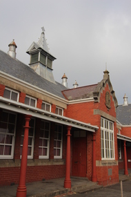
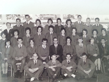 Ballarat Heritage Services
Photograph - Black and White, Ballarat East High School, Form 4B, 1962, 1962
Black and white photograph of a Ballarat East High School class. ballarat east high school, education -
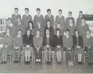 Ballarat Heritage Services
Photograph - Black and White, Ballarat East High School, Form 5C, 1963, 1963
Black and white photograph of a Ballarat East High School class.ballarat east high school, education -
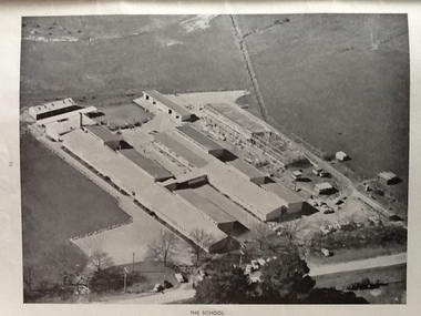 Ballarat Heritage Services
Photograph - Black and White, Ballarat East High School, aerial photographs
Three black and white photographs of the Ballarat East High School. ballarat east high school, education -
 Ballarat Heritage Services
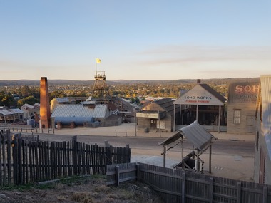
Photographs, PaulMichael Donovan, Ballarat East from Sovereign Hill, 2019, 12/04/2019
Ballarat East from Svereign Hill, including a poppet head.sovereign hill, ballarat east, soho foundry, chimney -
 Ballarat Heritage Services
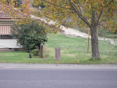
Photograph - Photograph - Colour, Milepost on Main Road, Ballarat East, 2008, 10/12/2008
Colour photograph of the mile post in Main Road, Ballarat East.mile post, ballarat east, main road, milepost, sign -
 Orbost & District Historical Society
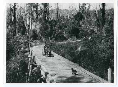
black and white photograph, 1913
This photograph is of the low level bridge across the Bemm River about 50 km east of Orbost in East Gippsland.This is a pictorial record of the 1913 low level bridge across the Bemm River, East Gippsland.A large black / white photograph of a horse - drawn wagon on the low level Bemm River bridge. In the foreground on the bridge is a dog.on back - "Country Roads Board Princes Highway low level bridge" -
 Orbost & District Historical Society
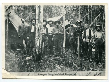
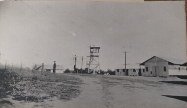
black and white photograph, 1897
This is a surveyors' camp in the McCulloch Ranges April, 1897. Surveyors were among the first European settlers to arrive in Australia. A Surveyor-General was present on the First Fleet, as well as the first two ships which landed in South Australia. These men were issued with instructions to record observations in a journal that included the country’s general appearance, its soil, flora and fauna and the customs and language of local inhabitants. The conditions they worked in were harsh and they embarked on journeys with drays carrying cumbersome surveying and camping equipment, spending months camping out in the bush and mapping the land. It was not until well into the second half of the nineteenth century that the professional training of surveyors became mandatory in Australia. This is a pictorial record of a surveyors' camp in the late 19th century.A black / white photograph of a group of men standing at a campsite in the bush. Two tents are in the background.on the front - "Surveyors Camp, McCulloch Ranges" Some names have been added for identification - Bates, Thorn and others which cannot be read.surveyors-camp-mcculloch-ranges land-settlement -
 Orbost & District Historical Society
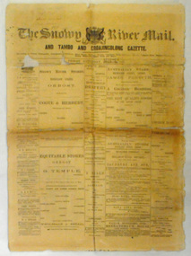
newspaper, Snowy River Mail, August 9 1890
Published as The Snowy River mail and Tambo and Croajingolong gazette from 1890 to 1911. The Gippsland Courier merged with the Snowy River Mail when proprietor Lachlan Ross moved to Orbost in 1910 In 1999 the paper was acquired by the Yeates family when the Hollins family retired from the newspapers business.The paper is still being produced by the fourth generation of the Yeates family as part of East Gippsland Newspapers. They also produce the Bairnsdale Advertiser, the East Gippsland News and the Lakes Post and the yearly publications East Gippsland Visitor Guide and the Great Alpine Road Touring Guide. This newspaper is still being produced today. Local newspapers play a vital role in communities as they are central to communication networks in regional areas of Australia. They are a valuable source of local news, act as a forum for debate and often set the agenda for local discussion. This item is a useful research tool as it reflects contemporary views.This newspaper is a first issue of 4 pp. It is titled "Snowy River Mail & Tambo and Croajingolong Gazette Orbost Saturday August 9 1890".snowy-mail-newspaper first-issue -
 Tatura Irrigation & Wartime Camps Museum
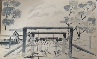
Photograph - Photographs, Camp 13 entrance gates
Sketch of the entrance gates of Camp 13 Murchison.Black and white photograph of a sketch of the entrance gates to Camp 13 Murchison, with huts to the left, behind the wire, a large tree behind the huts, and two trees on the right inside the yard. On coreflue.camp 13, murchison, camp entrances -
 Marysville & District Historical Society
Photograph (Item) - Black and white photograph, Camp Opposite The "Scandinavians', c1900
An early black and white photograph of a camp which was opposite The Scandinavian's Hotel and Boarding House along the Yarra Track.An early black and white photograph of a camp which was opposite The Scandinavian's Hotel and Boarding House along the Yarra Track. The Yarra Track is the former name of the gold fields road from Healesville to the Woods Point and Jordan Goldfields, in Victoria, Australia. A direct route via the Yarra River and the Great Divide was discovered by Rieck in September 1862 and became known as the Yarra Track. Early in 1863, the Victorian Government decided to construct a 193-kilometre (120 mile) road along the route. Its original width varied between 4 and 6 metres (12 and 20 feet), and was designed to accommodate horse-drawn vehicles. The Track involved the climbing of the Black Spur, descent into the Acheron Valley, and then through Marysville to the Cumberland where it followed the existing route.ARMSTRONG COLLECTION 42 STATION STREET/ SANDRINGHAM 3191/ TEL. (03) 9521 5442/ IAN M.L. ARMSTRONG OAMthe scandinavians', yarra track, healesville, wood's point, jordan goldfields, victoria, yarra river, great divide, reick, black spur, acheron valley, marysville, cumberland creek -
 Orbost & District Historical Society
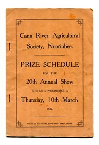
program, Snowy River Mail, 1927
Cann River is a town in the East Gippsland region of Victoria in Australia. The town is located on the Cann River at the junction of the Princess Highway and the Monaro Highway, in the Shire of East Gippsland. Before 1929 the original Cann River settlement was where Noorinbee now stands.Agricultural shows are an important part of cultural life in small country towns and these shows form an integral part of local history. This item reflects the significance of a volunteer group which no longer exists.A stapled paper program, orange with black print,"Cann River Agricultural Society, Noorinbee Prize Schedule for the 20th Annual Show to be held at Noorinbee on Thursday 10th March 1927" inside a rectangular black frame. -
 Lakes Entrance Historical Society
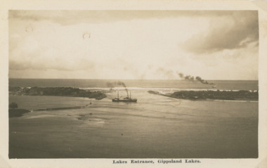
Postcard - Steamers on Gippsland Lakes, 1930 c
Black and white postcard showing a steamer leaving the Entrance channel and turning into Cunninghame Arm, a second steamer at sea beyond the Western Pier Lakes Entrance VictoriaLakes Entrance Gippsland Lakesships and shipping, transport, gippsland lakes, topography -
 Tatura Irrigation & Wartime Camps Museum
Photograph, Camp Buildings and sentry tower, 1939
Dhurringile camp view. General view of buildings, sentry tower and a lone guard.Black and white photograph of general view of huts, lookout tower, fence and lone soldier with road sweeping front right, swinging left. Taken at Dhurringile Mansion camp.dhurringile pow camp -
 Lakes Entrance Historical Society
Book, Reverend George Cox, Gippsland in the 1840's Vol 4, 1995
Edited articles from the Gippsland Standard Gippsland Victoriahistory, explorers, settlers -
Lakes Entrance Historical Society
Book, Reverend George Cox, Notes on Gippsland History Vol 5, 1995
Edited articles from the Gippsland Standard Gippsland Victoriahistory, explorers, settlers -
 Federation University Historical Collection
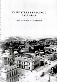
Book - Report, Camp Street Precinct Ballarat Conservation Management Plan, November 1999
This report was prepared for the City of Ballarat to assist in the process of planning for the future management and development of the Camp Street precinct.214 page report with spiral binding and a cover featuring a black and white image of the Ballarat Post Office, Ballarat Free Library and Ballarat State Offices. The report includes information on buildings in the Camp Street precinct including Art Gallery of Ballarat, old Colonists' Hall, former Police Court, former Police Station, Former Police Barracks, Government Camp (1852-1864), etcballarat fine art gallery, art gallery of ballarat, ballarat old colonists hall, ballarat former library, ballarat old court house, old ballarat police station, former ballarat post office, ballarat market reserve, ballarat benevolent reserve, bones building, old colonists hall, former ballarat call room, former ballarat police court, archaeology, aledandria tea room, former lister and angel warehouse, pratts warehouse, cms, conservation management plan, old colonists' hall, old colonists' association -
 Lakes Entrance Historical Society
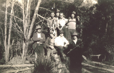
Photograph - The 4 Mile Camp Old Buchan Road, Buchan Victoria, 1935-36
Black and white photograph of eight bush workers Charles Pettman with a dog posed in a bush setting at the Four Mile Old Buchan Road East Gippsland Victoria. Names on second photoworkmen, engineering, government services -
 Orbost & District Historical Society
rate books, 1977 - 1984
These items were donated to Orbost & District Historical society from P.R.O.V. as a Place of Deposit (POD) item for safe keeping by a local history group or museum. The shire covered an area of 9,347 square kilometres and existed from 1892 until 1994 when it became part of the East Gippsland Shire Council. The East Gippsland Region Water Authority was constituted on January 1, 1995. The new Authority assumed responsibility for the services previously provided by the Mitchell Water Board, the Tambo Water Board, the Orbost Water Board and the Mallacoota Water Board. East Gippsland Water is the registered business name of the East Gippsland Region Water Authority. (info. from P.R.O.) These items are a historical record of Orbost Shire transactions with water management authorities which no longer exist.Seven rate books for the Shire of Orbost, Mallacoota and Cann River Water Trust. 2554.1 with records from 1977-1978 has a brown cardboard cover and string binding. 2554.2 has a brown cardboard cover with a hand-written title and green string binding. Records are from 1978 -1979. 2554.3 has a brown cardboard cover with a hand-written title and green string binding. Records are from 1919 - 1980. 2554.4 has a white cardboard cover and taped spine. In black print on the cover is 1980/1981. 2554.5 has a green cover with a metal fastening clip. Records are from 1980 -1981. 2554.6 has a white cover, taped binding and metal clips.Records are from 1982 -1983. 2554.7 has a white cover and metal rings. It is dated 1984.water-rates cann-valley-water-board -
Tatura Irrigation & Wartime Camps Museum
Audio Tape, Camp Construction and local history, 1993
Side A: Interview with Bill Ranson, construction of Camp 1 etc. 8 July 1993 - local history and irrigation. Side B: Interview with Charlie Hogan local history (Bill Martin) 14 July 1993Audio tape Akai SX90Bill Ranson - camp construction Charlie Hogan - local history - Bill Martinbill ranson, camp 1 construction, charlie hogan, bill martin -
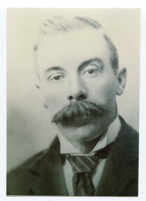 Orbost & District Historical Society
black and white photograph, C1926
This is a photograph of Councillor J. Walker who represented East Riding on the Orbost Shire council from 1915 - 1926.This item is associated with the Orbost Shire Council. The shire covered an area of 9,347 square kilometres and existed from 1892 until 1994 when it became part of the East Gippsland Shire Council.A black / white head and shoulders portrait photograph of a moustached man in a suit.on back - "Cr J. Walker, East Riding 1915-1926"walker-j. orbost-shire-council -
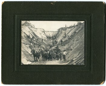 Orbost & District Historical Society
black and white photograph, early 20th century
There is no information with this photograph. It could be associated with the construction of the East Gippsland Railway.This is a pictorial record of construction work in the early 20th century. It shows the use of hand tools and horse and cart transport.A black / white photograph on a black buff card. It shows men working with picks and shovels to construct a pass. There is a horse and cart in the foreground.road-construction railway-construction civil-engineering -
Whitehorse Historical Society Inc.
Letter - Correspondence, WW2 army camp, Esdale Road, Nunawading, n.d
Note from Beryl Gray on an interview with Mr Mion of Haines St., Mitcham. Who stated that there was an army camp in Esdale Road, Nunawading during World War 2.Note from Beryl Gray on an interview with Mr Mion of Haines St., Mitcham who stated that there was an army camp in Esdale Road, Nunawading during World War 2.Note from Beryl Gray on an interview with Mr Mion of Haines St., Mitcham. Who stated that there was an army camp in Esdale Road, Nunawading during World War 2.mion, (mr), world war 1939-1945, esdale street, nunawading -
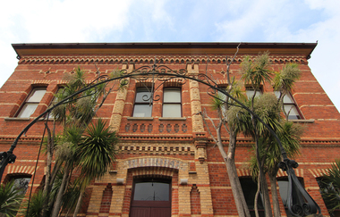 Victorian Interpretive Projects Inc.
Photograph - colour, Clare Kathleen Gervasoni, Former Ballarat East Library, 2015, 05/04/2015
Colour photographs of a brick building which is the former Ballarat East Library.ballarat east library, ballarat east high school, ballarat school of mines -
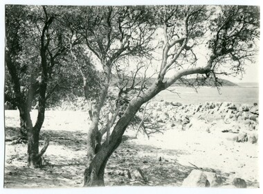 Orbost & District Historical Society
black and white photograph, first half 20th century
this photograph is of Cape Conran in Far East Gippsland. It appears to be a copy of a commercial postcard available to tourists or East Gippsland residents to send to friends or relatives.Cameras in the early 20th century were not a common family possession and a postcard was a common souvenir and way of sending a short message.Postcards form a vital part of social and historical records for researchers. A black / photograph of trees and a beach with rocks and the ocean in the background. It appears to be a copy of a postcard and has been hand trimmed.cape-conran -
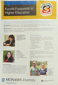 Federation University Historical Collection
Pamphlet - Brochure, Koorie Footprints to Higher Education, Gippsland, 1913, 2012
On 01 January 2014 Monash University Gippsland became a campus of Federation University Australia.Double side A3 sheet outlining a program for indigenous people to increase their knowledge about the university and to create opportunities to attend Monash University Gippsland. Photographs include Aunty Jenny Solomon, Gina Bundle, Nick Johnson, Vicky Murgha, Pauline Mackinnon, Bronwyn Boyce. Courtney Hales, Pro Vice-Chancellor Helen Bartlett.aunty jenny solomon, gina bundle, nick johnson, vicky murgha, pauline mackinnon, bronwyn boyce, courtney hales, helen bartlett., monash university gippsland, aborigines, aboriginal education centre, printmaking, koorie footprints, gippsland campus collection, nicholas johnson -
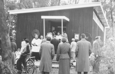 Ringwood and District Historical Society
Photograph, Church of England, Patterson Street, East Ringwood, Vic. - circa 1960
Church of England Church at East Ringwood with people leavingWritten on back of photograph, "E. Rwd." Church of England Church at East Ringwood -
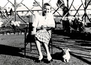 Tatura Irrigation & Wartime Camps Museum
Photograph, Warden G L Horton Camp 3, 1947
Given to Wally Wagner, an internee in Camp 3.Black and white photograph of Camp 3 Warden G. L. Horton seated in chair. Cat enjoying sun. Diamond design small wooden poles, lattice work in front of five Army huts."To Wally with my very best wishes, G L Horton 23/7/1947"internee children, camp 3, warden g. l. horton, camp 3 wardens -
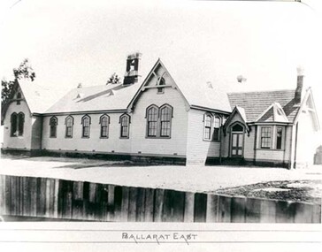 Federation University Historical Collection
Photograph - Photograph - black and white, Ballarat East State School (No 1071)
The weatherboard Ballarat East State School SS 1071 was formerly known as Specimen Hill. According to 'Visions and Realisations' The Eureka gold lead opened in August 1852, running from Little Bendigo, south beneath Yarrowee Creek into Pennyweight flat, where it was joined 100 yards or so from the intersection of main and Eureka Streets by the Canadian Lead. State School 1071 was formerly known as Ballarat Common School No. 71, and was founded by the Free Presbyterian Church on Specimen Hill in Eureka Street, Ballarat on 01 January 1854. On 20 May 1869 the trustees of the Presbyterian School, Specimen Hill, Ballarat, consented to the transfer of the site to the Board of Education. On 01 September 1870, Specimen Hill, Ballarat, was vested in the Board and then became known as SS 1071. On 01 March 1879 the Minister, The Hon. William Collard Smith, and William Dobbie, Inspector of School Buildings, visited Ballarat to report on the buildings with a view to extensions and renovations. The minister issued instructions for the old wooden part of the school to be demolished, and brick additions to be erected, so that the whole premises would accommodate 350 students. (''Visions and Realisations: A Century of State Education in Victoria, Vol. 2'', Education Department of Victoria, 1973, p 729-730.)Black and white photograph of a weatherboard school with shingle roof known as Ballarat East (SS1071). The building has a brick chimney and bell tower. This school has Castlemaine flagging in the passages.ballarat east state school, education, st paul's school, specimen hill state school -
 Lakes Entrance Historical Society
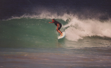
Photograph - Roger Noden, Vinnie, 1999
Roger Noden East Gippsland Team Manager for the Guannanatta Teams Surfing TitlesColour photograph of Roger Noden East Gippsland Team Manager for the Guannanatta Teams Surfing Titlessports, surfing