Showing 123771 items matching "main-road"
-
 Ballarat Tramway Museum
Slide - 35mm slide/s, Peter Moses, 21/08/1971 12:00:00 AM
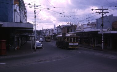
Photo of SEC Ballarat No. 42 after turning from Main St into Bridge St while running on the ARHS/TMSV special trams prior to closure. Tram 42 showing destination of "Special". No. 11 in the background. Kodak cardboard mount slide, taken by Peter Moses 21 August 1971.On the rear of the slides in blue ink "N42 Ballarat / Bridge St near Main St." and "P. Moses" in the bottom left hand corner in black ink on the other side of the slide.tramways, trams, bridge st, main st, special trams, tram 42 -
 Southern Sherbrooke Historical Society Inc.
Photograph, Belgrave from Biffin's Hill
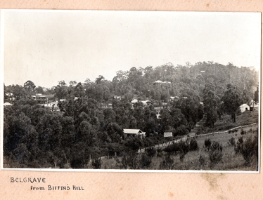
Photo of Belgrave township from Biffin's Hill (present-day site of Mater Christi School). Road running across front of photo is now Belgrave-Gembrook Rd. There is a sign on the side of the road advertising Biffin Hill Estate for sale. Belgrave main street is visible in background. c. 1920s -
 Whitehorse Historical Society Inc.
Photograph, Railway Crossing from the north, 1/06/2009
One of a collection of photographs taken of the Nunawading Railway Station prior to the lowering of the railway line and building of the new railway station on the western side of Springvale Road so that the Springvale Road Rail Crossing can be eliminated.Black & white photograph of the precinct surrounding the Nunawading Station and the Springvale Road Railway crossing. This photograph is of the railway crossing of Springvale Road, Nunawading, looking to the south of the shops. See NP 3545 to NP3567 for the complete set of photographsnunawading railway station, springvale road nunawading, redevelopment of railway line/springvale road. -
 Phillip Island and District Historical Society Inc.
Photograph, 1960's
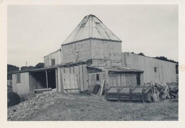
Donated by N. M. & J. D. Archibald. April 1973Black & White Photograph. Chicory Kiln. Cowes, Main Road - Mr. G. Stoppa. Cement blocks with Iron, Wood & Fibro. Built late 1940's or 50's. Chicory Kiln Album.local history, photography, photographs, agriculture buildings, historic, chicory kiln, cowes, phillip island, g stoppa, n & j archibald -
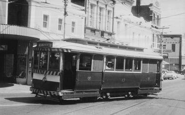 Ballarat Tramway Museum
Photograph - Digital image, c1971
Yields information about Ballarat streetscape and its trams in the closing days of the SEC tramway system.Digital image from a black and white print of tram 13, turning from Bridge St into Main Road outbound for Mt Pleasant with the various buildings on the southside in the background. Photo by Marc Dahlstrom c1971. On rear is the Marc Dahlstrom stamp.trams, tramways, bridge st, stones corner, tram 13 -
 Melton City Libraries
Photograph, Western Highway, 1983
Construction of service road in front of the former Ann Dowling (Miers) 1866 Crown Grant, Title dated October 1870. She married Henri Miers in 1867.Their house was located on the site near the Myers Gully part of Ryans Creek. Built in 1867 and later named “Burnbank” by Martha Myers after the Street in Ballarat were she lived before arriving in Melton in 1907. She married Frederick Myers in 1908. He died in 1963, and Martha moved to a new home at 5 McKenzie Street Melton in 1968. Attempts made by the family to retain the historic cottage were unsuccessful. A demolition order imposed by the Housing Commission and it was pulled down by the family. It was the home of the family and stood for over 100 years.East of Reserve Road towards Ferris Roadlandscapes of significance, misc. -
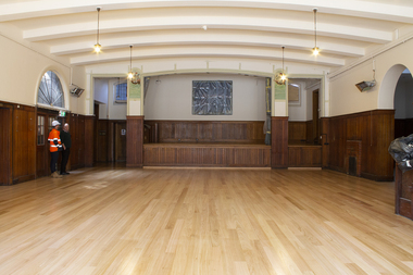 Mission to Seafarers Victoria
Photograph - Digital photograph, series, 2019
Long awaited building renovations in 2019 commenced with the replacement and upgrade of the 102 year old floorboards in the main hall and old Billiard room of the Mission to Seafarers Victoria. Some stumping replaced and repaired in places. Many older seafarers especially recall the regular dances hosted by chaperoned local young women and members of the Ladies Harbour lights Guild that commenced in the 1930s and carried on through to the 1960s. (see also significance statement)These photographs are another historical record. As a listed Building of Heritage significance the Mission to Seafarers commenced in consultation with heritage advice as per Burra Charter, the first phase of renovations to the century old building complex at 717 Flinders St which is still providing services and facilities to seafarers as per the original purpose and design. The club room or main hall was the sight of many performances, slide shows, film screenings, and events to entertain or raise funds for the Mission. Series of photographs depicting the new floor boards in the main hall, Flying Angel Club after renovation winter 2019 and before recarpetingbuilding renovations, flying angel club -
 Whitehorse Historical Society Inc.
Photograph, Childhood Home of Jean Chalmers
Coloured photo - Childhood Home of Jean Chalmers Gorsuch in East Doncaster Road, Mitcham, opposite Uniting Church. Her parents, Hilda & Fred Chalmers, lived in house since marriage.gorsuch, jean, chalmers, fred, hilda, fry, judith -
 Orbost & District Historical Society
black and white photographs, 1976 - 1977
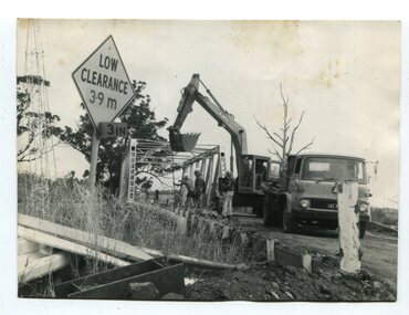
These photographs are of the demolition of the road bridge across the Snowy River at Orbost. This bridge over the Snowy River was opened on July 4 1922. It was constructed in 1922 alongside the previous suspension bridge. Its building was a combined effort of the Victorian Railways and the Country Roads Board at a cost of 35,000 pounds. It was replaced in 1976 by the present bridge after several major floods.This bridge was replaced in 1976 after several major floods. These photographs are pictorial records of its demolition.Four black / white photographs of the demolition of a road bridge across a river. In them can be seen trucks, excavators and workmen. In 3246.1 there is a triangular road sign - "LOW CLEARANCE 3.9m"bridge-demolition orbost-snwoy-river-bridge -
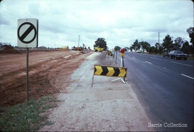
 Orbost & District Historical Society
black and white photographs, C1975
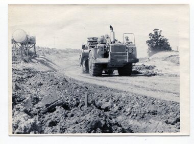
These four photographs show the construction of the Princes Freeway on the eastern edge near the cemetery. of the Orbost township. The road is from the eastern entrance to the cemetery.These photographs are pictorial records of the construction of roads in Orbost.Four black / white photographs of road construction machinery.road-construction-orbost roadwork-orbost-cemetery -
 Halls Gap & Grampians Historical Society
Photograph - B/W, C 1926
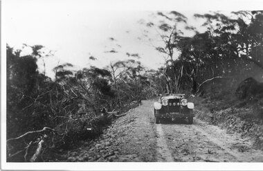
Mirranatwa Gap was originally known as Yarram Gap; this name was given to the opposite gap on the Mt William side of the Dunkeld Road sometime in the mid 20th century. An early touring car, claimed to be the first, crossing Mirranatwa (then Yarram) Gap.Photo shows car on Yarram Gap Road Road is rocky and unsealed. trees on left side of photo has been felledaccess routes, roads, yarram gap -
![Construction of the electric tram line in Cotham Road [Kew]](/media/collectors/550653872162f11fb04854aa/items/662870846214a76cee3aecf0/item-media/662870de6214a76cee3af7de/item-fit-380x285.jpg) Kew Historical Society Inc
Kew Historical Society IncPhotograph - Construction of the electric tram line in Cotham Road [Kew], E.J. Dower, 1913
One of a small album of six photographs of the construction of the Cotham Road tramline in Kew, taken by Edgar James Dower in the second decade of the twentieth century. The reverse of each photo contains notes, written over time by the photographer, which are contained in the 'Inscriptions' field. Born and raised in Olinda, Dower's family later moved to Surrey Hills. He worked as an adult as a clerk in the city office of the Metropolitan Gas Company, and in his role as a 'collector', he was able to photograph scenes including the construction of tram and train lines and associated buildings in Kew, Hawthorn, Camberwell and Surrey Hills. Later he established a real estate agency with his brother - the E.J. Dower Real Estate Agency, Dandenong Office. The album as a whole can be viewed separately as the parent file.The image is an historically significant record of the development of transport infrastructure which was used to connect Victorians in the first two decades of the twentieth century. This development resulted from increases in population and the consequent extension of Melbourne's suburbs. The photographs in the album, as well as Dower's single photos mounted on card, individually and collectively richly detail the labour of workers and the tools and machinery used to create and extend Melbourne's tram and train networks in the years preceding and during World War 1.The first of six annotated photos in an album of photographs of the construction of the St Kilda to Kew electric tram line, taken in Cotham Road, Kew, by the amateur photographer, Edgar James Dower, in 1913. The album contains images detailing the preparation for the laying of the tracks plus work laying the line. The photographer notes on a number of the photos that te metal tracks were collected from the Hawthorn railway siding. The album, together with other phots by E.J. Dower has been made available by the owners for the Kew Historical Society to digitise and publish online and in print.Annotation verso: "1913 / Preparing for electric trams in Cotham Road Kew, looking west / Taken from corner of Burke Road by E.J. Dower / The metal was brought by horse and drays, from Hawthorn rail-way siding".keywords, theme -- connecting victorians by transport and communications, theme -- travelling by tram, photographers -- edgar james dower, cotham road -- kew (vic.) -
 Linton and District Historical Society Inc
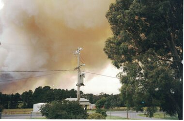
Photograph, Linton Bushfire, 1998, December 1998
Linton bushfire 1998, Snake Valley Road area, five Geelong West firefighters died in this fire.Colour photograph of bushfire smoke over Linton."Linton Fire December 2, 1998/Looking North on Skipton Road".bushfires -
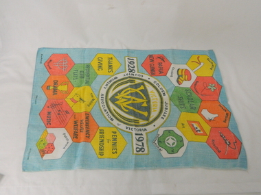 Kiewa Valley Historical Society
Towel Tea CWA, circa mid to late 1900's
This tea towel was manufactured in 1978 in Ireland and shipped to Australia. This was in a period when the C.W.A. was the major women's organisation which had the greatest influence amongst rural women (especially in isolated areas). This was a period when broad based communications were mainly by radio,women orientated magazines and the telephone. The relay of television to "remote" rural areas was not yet established. The CWA was therefore a very important organisation that catered exclusively to women's needs. The C.W.A. motto "Honour our God, Loyalty to the throne, Service to the country, Through country women, For country women, By country women." The atmosphere was one of "sisterhood" and covered nearly all the needs of rural based women. This one organisation incorporated knowledge and learning targeting women who physically may be isolated but not mentally. On the tea towel are portrayed all the activities that would be beneficial to rural women.This tea towel with its respective motifs is very significant to the Kiewa Valley as it related especially to women who felt the limitations of social interactions within a rural area. This tea towel represents a era where communications was relatively based on radio, magazines, books and limited telephone access. Within these restrictive interactive communication levels, the isolation of a "back o' Bourke" location applied tremendous mental fatigue on women more than on men.This CWA Victoria Golden Jubilee (1928-1978) tea towel is made from Irish flax at the Blackstaff Flax Spinning and Weaving factory. It is therefore of high quality and very durable. The major colours projecting from a light blue background are red, yellow, green, orange and black. The motives portrayed the activities of the CWA in 1978. These activities are embroidery, crocheting, dress making, knitting, cooking, art, macrame, drama, music, patchwork, toy making and community relief, pennies for friendship, emergency relief and welfare, residential club flats, the thanks giving and Papua New Guinea.The main or central theme of this tea towel is presented in the central area within three rings. "1928" on the left and "1978" on the right. On the top part "GOLDEN JUBILEE" and at the bottom "COUNTRY WOMEN'S ASSOCIATION OF VICTORIA" There are various shapes representing the activities listed above.cwa promotional material, cwa golden jubilee, women only organisations, country women's association -
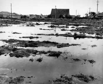 City of Kingston
Photograph - Black and white, c. 1958
Unsealed roads and drainage problems created difficulties for those living in Beaumaris during the 1950sBlack and white image depicting the Balcombe Road and Haywood Street, Beaumaris. Unsealed roads and drainage problems have created boggy slushy land. There are houses in the background, indicating people live in the area.Handwritten in red ink on reverse: 90% Handwritten in blue ink on reverse: 2193beaumaris, roads, drainage, water logged, housing -
 Sunbury Family History and Heritage Society Inc.
Photograph, Rosa McCall, Old Broadmeadows Township, 1949
The small town in the photograph is the former Broadmeadows Township (now part of Westmeadows). It was situated on the Old Sydney Road (Mickleham Road) and 2 miles east of the Broadmeadows Station. The stone bridge in the foreground spans the Moonee Ponds Creek and Fawkner Street is the road, which leads southwards to Gladstone Park and Tullamarine. The little building was a lolly shop that Mrs. Ethel Mitchell owned and ran for many years.Until 1869, before Sydney Road was finally opened, travellers on their way to Sydney would pass through the Broadmeadows Township.A copy of a non-digital black and white photograph of a road way with a bridge in the foreground leading to a small settlement. Small building with a pitched roof and a verandah is on the RHS of the image and the road leading out of the town is bordered with an avenue of pine trees.old broadmeadows township, fawkner street, moonee ponds creek, westmeadows, bridges -
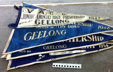 Geelong Cycling Club
Pennant Flags
These Pennant Flags were awarded to cycling clubs for road cycling competitions.The award of these pennants to the junior members of the Geelong West Cycling Club indicates the strength and popularity of competition cycling at the time.Triangular Pennant Flags. 3 flags are in blue felt with white inscriptions and one flag is in white felt with black inscriptions."VACU/Junior Country Road/ Premierships/Geelong/1947/1948/1950/1954"vacu; junior country road/; premierships; geelong; 1947; 1948; 1950; 1954; -
 Linton and District Historical Society Inc
Photograph, Mrs. Norris' House, Linton, 1937
This house was sold by the Knights approx 1970, and moved to the Linton-Piggoreet Road.Black and white original photograph of five people standing on the verandah of a late Victorian house."Mrs Norriss's house Skipton road Linton 1937 later Knights home".houses, mrs norris, knight family -
 Ringwood and District Historical Society
Photograph, Cadbury's, Canterbury Rd (undated)
Warehouse, not the main factory.Written on back of photograph, 'Cadbury's, Canterbury Rd.' -
 Glen Eira Historical Society
Document - Capek, Irene Mrs
Typed notes by Irene Capek dated February 2001 describing her neighbor Rose, a long time resident of Norwood Road, and changes to the housing in Norwood Road, Caulfield North.capek irene, orrong road, dandenong road, caulfield, caulfield north, norwood road, suburban lifestyle, rose -
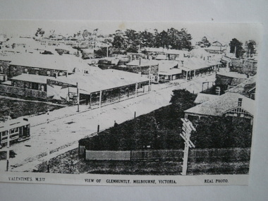 Glen Eira Historical Society
Photograph - Vermador
Two black and white photocopies of a photograph of Vermador Private Hospital at 761 Glenhuntly Road, corner Watson Grove and Glenhuntly Road, taken c. 1920, Sr. Mary Stuart.glen huntly, vermador, hospitals, watson grove, stuart mary, streetscapes, glen huntly laundry, drapers, advertising signs, glenhuntly road, glenhuntly -
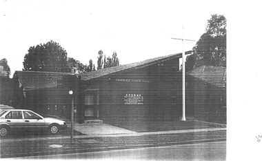 Box Hill Historical Society
Photograph - Chinese Evangelical Church, 1994
View of the Chinese Evangelical Church at 644 Elgar Road near the intersection of Belmore Road, Box Hill North. The Church is built in brick and features a large cross in front of the Church.B&w photochurches, elgar road, belmore road, box hill north, chinese evangelical church -
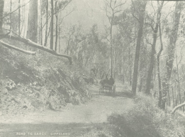 Lakes Entrance Historical Society
Photograph - road to Dargo Victoria, 1900 c
Road to Dargo GippslandBlack and white photograph of a horse drawn vehicle on a road through bushland on the way to Dargo Victoriatransport, roads and streets, topography -
Whitehorse Historical Society Inc.
Document, Ellis Stone's medisan planting, 1/05/2001 12:00:00 AM
'Ellis Stones' median planting, Canterbury Road, Vermont.'Ellis Stones' median planting, Canterbury Road, Vermont. Brochure describing median strip landscaping in Canterbury Road, Vermont undertaken by Ellis Stones in 1974 and details of proposed replanting.'Ellis Stones' median planting, Canterbury Road, Vermont. stones, ellis, canterbury road, vermont, roads and streets, landscape planning, city of whitehorse -
 Robin Boyd Foundation
Slide, Robin Boyd, 1965
Colour slide in a mount. BP House (1964), St Kilda Road, Melbourne, Australia. (Architect: Anthony B Armstrong.)Made in Australia / 6 / JAN 65M / B-P St Kilda Road 1964 (Handwritten) / Detail: See also no.7. (Handwritten)melbourne, robin boyd, slide -
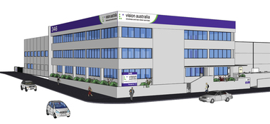 Vision Australia
Drawing - Image, Vision Australia Kensington exterior artists view, 2009
Artist impression of the new building for Vision Australia's office in Macaulay Road, Kensington in 2009.4 digital files depicting artists view of Macaulay Road officevision australia, macaulay road kensington -
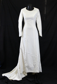 Whitehorse Historical Society Inc.
Clothing - Wedding Dress, 1966
Dress made by Ludmilla Jenkins at her shop in North Road, Ormond. The dress was made for Rosalie Schwerkolt for her marriage to Marvin Bruce Whalen at St Andrew's Presbyterian Church, Gardiner, Victoria on Wednesday 1st June, 1966 and afterwards at Butleigh Wootton, 867 Glenferrie Road, Kew. Rosalie was married from 33 Straughton Road, Glen Iris.Rosalie is the great granddaughter of Johann August Schwerkolt, pioneer of Mitcham.1966 wedding dress of silk, velvet in Winter White colour lined in silk voile. The dress is a princess line with round crew neck. Sleeves are narrow and taper to a point using a dart and with a zipper fastening on seam. The arm seam also features three pleats at the inside of the elbow crease. The back has a zipper closing and princess line seams. The gown is full length at the front and at the back extends to a point for a 40cm train using an insert gore in the princess seam. Approximate measurement bust 31 inches or 79 cm waist 24.5 inches or 62 cm Hip 36 inches or 94 cm See also items NA5076 - Garter NA5077 - Good luck Charm NA5078 - Bible NA5090 - Stocking NA5091 - Veil Nonecostume, female ceremonial -
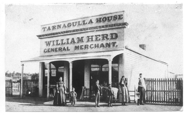 Tarnagulla History Archive
Photograph of Herd's Store, Tarnagulla, Herd's Store, Tarnagulla, Between 1852 and 1910
Murray Comrie Collection. Information collated by Murray Comrie: William Herd was born in Scotland in 1829, and came to Australia in 1852. He set up a business at Hard Hills and then and the lower end of the main lead at Sandy Creek (Tarnagulla). He then purchased a business from a Mr. Turnbull in Commercial Road where he built this large store. He was a member of the first Borough Council in 1864 and Mayor on several occasions. Herd died in 1899, aged 70 and his son carried on the business for several years. This building was later moved to Metelman's farm in Arnold West to be used as barn (and was as late as May 1970), as shown in THA-2019.0055. This photograph is a reasonable copy created from an older original. Copy probably made by Murray Comrie in the 1970s. Monochrome photograph depicting a high storefront with text 'Tarnagulla House William Herd General Merchant'. Group of people standing in front of store. Picket fencing either side.tarnagulla, commerce, shops, stores, herd's, william herd, commercial road, main street, council, councillors, mayor -
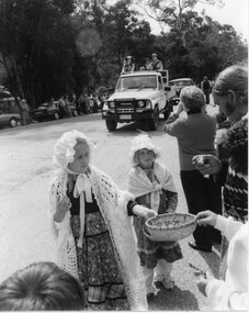 Halls Gap & Grampians Historical Society
Photograph - B/W, Oct-86
This is part of a parade held on the main street of Halls Gap in conjunction with the 150th anniversary of Major Mitchell's visit to the area. The photo shows two young girls wearing flower patterned dresses, frilly hats and shawls standing on the edge of a road. The front girl is offering flowers in a straw basket to people lining the street. A Toyota land cruiser with people dressed in what appears to be park ranger or scout uniforms standing in the tray is driving down the road and an old car can be seen behind that. People and cars line the far side of the road and trees can be seen behind them.events, parades -
Camberwell Historical Society
Photograph - Photographs, Ella Keesing, Palace Hotel photographs, 1989
Palace Hotel on Burke Road was built in 18899 photographs of Palace Hotel on Burke Road. Photographs taken by Ella Keesing in 1989. camberwell, hotel