Showing 11460 items matching "maps "
-
 Falls Creek Historical Society
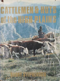
Book - Cattlemen & Huts of the High Plains, Harry Stephenson, 1980
This book records the development of Victoria's alpine regions by the pioneer cattlemen. They came from the Monaro in the 1830s to reach the Plains of Omeo while others advanced up the Murray tributaries to discover the Bogong High Plains in the 1830s and the Gippslanders moved their herds to Alpine pastures in the 1860s. The cattlemen, the snow plain pastures, the mountain scene and the bush huts are described and illustrated in this volume. It records an era in Australia whose story is becoming lost.This volume of 350 pages includes 34 maps, 326 illustrations and diagrams. It has a brown cloth with white lettering and a pictorial jacket featuring cattlemen on the High Plains. It includes an index and bibliography. The front page has an inscription which indicates it had been given to Ore Frueauf of Falls Creek.non-fictionThis book records the development of Victoria's alpine regions by the pioneer cattlemen. They came from the Monaro in the 1830s to reach the Plains of Omeo while others advanced up the Murray tributaries to discover the Bogong High Plains in the 1830s and the Gippslanders moved their herds to Alpine pastures in the 1860s. The cattlemen, the snow plain pastures, the mountain scene and the bush huts are described and illustrated in this volume. It records an era in Australia whose story is becoming lost.victorian high country, mountain cattlemen, victorian high plains -
 Bendigo Historical Society Inc.
Map - UNITED HUSTLER'S & REDAN MINE - TRANSVERSE SECTIONS N & S OF SHAFT UNITED HUSTLER'S & REDAN MINE
Transverse Sections N & S of Shaft United Hustler's & Redan Mine on the Hustler's Line of Reef Bulletin No 33, Plate No XXX. Map shows some of the stone encountered on the levels and depth. Geological Survey of Victoria emblem and signed by H A Whitdan, Underground Survey Office Bendigo, September 1913.mining, parish map, united hustler's & redan mine, transverse sections n & s of shaft united hustler's & redan mine, hustler's line of reef -
 Melbourne Tram Museum
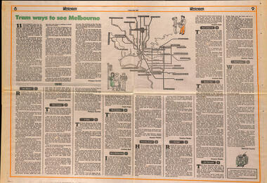
Newspaper, The Age, "Tram ways to see Melbourne", 8/5/1981
... Maps ...Newspaper clipping, from The Age, Weekender, Friday 8/5/1981 titled "Tram ways to see Melbourne", with a number of writers giving a short piece on a particular line. Has a Map of the Melbourne system with destination and route numbers. Has an introduction written by Phillipa Hawker which looks at the history, its place in Melbourne, and possibilities for the future. Written just before the MTA came into existence. Items: East Malvern, Route 3, Rebecca Batties West Preston Route 10, Phillipa Hawker St Kilda, Route 12, Frank Prain North Balwyn, route 48, Andrew Bolt West Maribyrnong route 57, Rosslyn Beeby Essendon Airport, Route 59, Rosslyn Beeby Carnegie, Route 67, Andrew Bolt Kew Cotham Rd, route 69, Andrew Bolt Wattle Park, route 70, Rosslyn Beeby East Burwood, route 75, Rosslyn Beeby East Preston, route 88, Deborah Forster Has some sketches of trams and people.trams, tramways, melbourne, people and places, tourism, east malvern, west preston, st kilda, north balwyn, west maribyrnong, essendon airport, carnegie, kew- cotham rd, wattle park, east burwood, east preston, route 3, route 10, route 12, route 48, route 57, route 59, route 67, route 69, route 70, route 75, route 88, maps -
 Eltham District Historical Society Inc
Negative - Photograph, J.A. McDonald, Eltham, Haldane Road, Mar. 1961
Dr Donald Thomson's gate and entrance to his property 'Worlingworth' after flooding in March 1961 "Worlingworth", Eltham, was the home of noted anthropologist the late Professor Donald Thomson and his wife Dorita. The entrance gate on Banoon Road is located at the bottom of the hill opposite Haldane Road. The flooding issues were regularly reported to Council following heavy rain. Google Street View Feb 2014 https://goo.gl/maps/SGjsJAAEdjQXgo5V9Record of various Shire of Eltham infrastructure works undertaken during the period of 1952-1962 involving bridge and road reconstruction projects, sometimes with Eltham Shire Council Project Reference numbers quoted. It was during this period that a number of significant improvements were made to roads and new bridges constructed within the shire that remain in place as of present day (2022). In many situations, the photos provide a tangible visible record of infrastructure that existed throughout the early days of the Shire. The album was put together by or under the direction of the Shire Engineer, J.A. McDonald.infrastructure, shire of eltham, 1961-03, flood damage, haldane road, prof donald thomson, worlingworth -
 Bendigo Military Museum
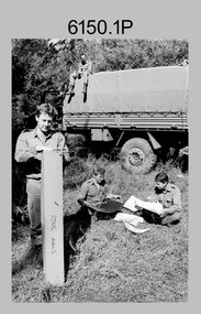
Photograph - Photographic Technicians performing tasks at the Army Survey Regiment, c1970s
These eleven photographs were most likely taken in the 1970s in Lithographic Squadron at the Army Survey Regiment, Fortuna, Bendigo. Although Photo .1P is not annotated the remainder have the technician’s name written on the back. The equipment operated by the technicians is not identified. The dates are unknown but most of these photos were probably taken the late 1970s. The main tasks undertaken by the technicians were most likely enlargements, reductions and duplication of map reproduction material, and aerial photography.This is a set of photographs of technicians operating photographic reproduction equipment at the Army Survey Regiment, Bendigo c1970s. The photographs were printed on photographic paper and are part of the Army Survey Regiment’s Collection. The photographs were scanned at 300 dpi. .1) - Photo, black & white, c1970s, unidentified, Lithographic Squadron .2) - Photo, black & white, c1970s, Gary Drummond, Lithographic Squadron .3) - Photo, black & white, c1970s, John Scott, Lithographic Squadron .4) - Photo, black & white, c1970s, WILD U4A Diapositive Camera, Bob Chamberlain, Lithographic Squadron. 5) - Photo, black & white, c1970s, WILD U4A Diapositive Camera, Zoe (Lisiewich) Ames, Lithographic Squadron .6) - Photo, black & white, c1970s, Garry Hudson, Lithographic Squadron .7) - Photo, black & white, c1970s, Garry Hudson, Lithographic Squadron .8) - Photo, black & white, c1970s, Garry Hudson, Lithographic Squadron .9) - Photo, black & white, c1970s, Mick Ellis, Lithographic Squadron .10) - Photo, black & white, c1970s, Col Darch, Lithographic Squadron .11) - Photo, black & white, c1970s, Phil Beatty, Lithographic Squadron.1P – no annotation .2 to .11 – personnel names (less rank) annotated on back. royal australian survey corps, rasvy, army survey regiment, army svy regt, fortuna, asr, litho -
 Bendigo Military Museum
Photograph - Lithographic Squadron Regimental Training, Army Survey Regiment, Bendigo, 1989
This is a set of 24 photographs of Army Survey Regiment’s Lithographic Squadron personnel undertaking regimental training in an unknown location in April 1989. The purpose of the training was probably to provide personnel a practical knowledge of navigation and map reading, RATEL and Survival in the Field, vehicle camouflage, teamwork and leadership. The training did not include infantry and minor tactics due to the absence of weapons. Although these photos are not annotated other than the month and year, most personnel are positively identified.This is a set of 24 photographs of personnel from Lithographic Squadron, Army Survey Regiment, Fortuna, Bendigo, undergoing regimental training in April 1989. The photographs were on 35mm negative film and scanned at 96 dpi. They are part of the Army Survey Regiment’s Collection. .1) - Photo, black & white, 1989, background L to R: Frank Lenane, Bill Jones, foreground L to R: Gavin McLean, Colin Yeats, Peter Dillon. .2) - Photo, black & white, 1989, Rhys De Laine. .3) - Photo, black & white, 1989, L to R: Peter Breukel, Colin Yeats. .4) - Photo, black & white, 1989, L to R: Colin Yeats., Peter Dillon. .5) - Photo, black & white, 1989, L to R: Graeme Spong, Gavin McLean, unidentified (x2), Peter Breukel, Steve Burke, Bill Jones, Colin Yeats. .6) - Photo, black & white, 1989, L to R: Graeme Spong, Bill Jones, Colin Yeats, Peter Dillon, Peter Breukel, Steve Burke, Colin Yeats. .7) - Photo, black & white, 1989, L to R: Graeme Spong, Bill Jones, Colin Yeats, Peter Dillon, .8) - Photo, black & white, 1989, Colin Yeats. .9) - Photo, black & white, 1989, L to R: Gavin McLean, Colin Yeats. .10) - Photo, black & white, 1989, L to R: Steve Burke, Peter Breukel, Colin Yeats, unidentified. .11) - Photo, black & white, 1989, L to R: Steve Burke, Peter Breukel. .12) - Photo, black & white, 1989, L to R: Peter Breukel, Steve Burke. .13) - Photo, black & white, 1989, Craig Hersant. .14) - Photo, black & white, 1989, L to R: Rob Bogumil, Darren Maher, Paul Baker, Rob Jones, Shona Hastie, unidentified, Chad Hardwick. .15) - Photo, black & white, 1989, L to R: Chad Hardwick, unidentified, Rob Bogumil, Rob Jones, Darren Maher, unidentified, Paul Baker. .16) - Photo, black & white, 1989, L to R: Rob Bogumil, Darren Maher, Chad Hardwick, Rob Jones, unidentified (x2), Paul Baker. .17) to .22) - Photo, black & white, 1989, unidentified personnel applying camouflage to truck. Shona Hastie in truck, .23) - Photo, black & white, 1989, L to R: LT Dave Weston, LT Craig Hersant, Trevor Osborne, Bill Jones. .24) - Photo, black & white, 1989, L to R: Andrew Arman, unidentified, Peter Dillon, Steve Burke, Colin Yeats, Peter Breukel. No personnel are identified. Annotation dated April 1989.royal australian survey corps, rasvy, army survey regiment, army svy regt, fortuna, asr, litho -
 Stawell Historical Society Inc
Book - Science, The Natural History of Western Victoria, 1974
Reports from Symposium of Australian Insitutes of Agricultural Science, held in Horsham 1971. 8 chapters, 7 of science 8th extracts from Stapylton's Journal of Western Victoria, when travlling with Major Mitchell. Contains fold out Maps & photos. 1) Geology & Geomorphology 2) Soils 3) Vegitation 4) Birds 6) Aborigines 7) the first hundred years of agricultural development 8) The Journal of Granville William Chetwynd StapyltonSoft Yellow Cover and Black with Black taped spineBarry Clugston -
 Mt Dandenong & District Historical Society Inc.
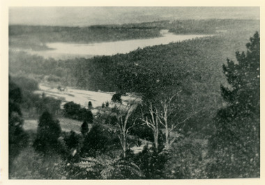
Photograph, View Over Roof of "Kalorama"
Taken in 1908, this photograph, though rather blurry, gives an indication of the location of the early settler properties in the valley in relation to one another. European trees have been planted at 'Kalorama' , the first home of Ellis Jeeves. John Lundy-Clarke grew up in the Kalorama/Mt Dandenong area and later in life (1972-74) began to write a comprehensive history of the area working from an original settlement map in an effort to cover all areas.Black and white photograph looking across hillside with large trees and rooftops visible. Handwritten description on reverse by John Lundy-Clarke.1908 View over roof of “Kalorama” towards the Falls. Paynter’s house on LOT 29 in low centre (now “Yosemite”). Pimms house on LOT 19 above Paynters and beyond scrub. Logan’s house faint above left of “Kalorama”. Dunbar’s LOT 20 beyond Pimm’s orchard. Gum trees on right were on Price’s LOT 19 now Tosari Rd area. It was one of these that figured in the episode of the runaway log in 1930. It leaped in one bound over Barbers Road at bottom of scrub in centre of picture then over Logan’s house.kalorama, ellis jeeves, jeeves -
 Mt Dandenong & District Historical Society Inc.
Photograph, Harmony Vale 1933
John Lundy-Clarke grew up in the Kalorama/Mt Dandenong area and later in life (1972-74) began to write a comprehensive history of the area working from an original settlement map in an effort to cover all areas. Harmony Vale was the name of the homestead built by early pioneer Jabez Richardson. The whole of the valley took on this name. The building lasted until 1933. The Silvan Dam was completed in 1932 and was full when this photograph was taken.Black and white photograph looking down over a forested area with a dam in the background. Copied from a Rose Series postcard c1933. Handwritten inscription on reverse by John Lundy-ClarkeRose Series photo of 1933 showing “Harmony Vale” still standing. Copied 1973 JLCharmony vale, silvan dam, jabez richardson -
 Mt Dandenong & District Historical Society Inc.
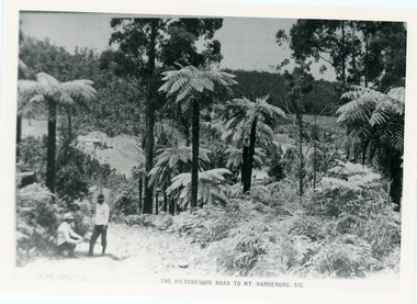
Photograph, View From Doughty's Road 1913
Mt Calvin, the homestead of Jeanie and Willie Richardson can be clearly seen in the clearing above the men in the picture. The white roof of the Barber homestead is on the right of the picture. A landslide in 1934 destroyed the tree ferned area. John Lundy-Clarke grew up in the Kalorama/Mt Dandenong area and later in life (1972-74) began to write a comprehensive history of the area working from an original settlement map in an effort to cover all areas.Black and white photograph that is a copy of a Rose series postcard titled 'The Picturesque Road to Mt. Dandenong. Vic.' It shows two men (probably Rose Series employees), one sitting and one standing at the edge of an unmade road. Large tree ferns line the roadside. Handwritten inscription on reverse by John Lundy-Clarke1913 View east from Doughty’s Road showing Jeannie Richardson’s home through the gap in the trees. A little to the right of and below centre of picture can be seen George Barber’s home with Barbers Road turning around the wagon shed that was a little up the hill from the house. The tree ferns in the picture were destroyed in the landslide of 1934. In the distance at the right can be seen F.M. Childs Homestead complex with the Richardson paddocks beyond it.mt calvin, jeanie richardson, willie richardson, george barber, landslide, tree fern -
 Mt Dandenong & District Historical Society Inc.
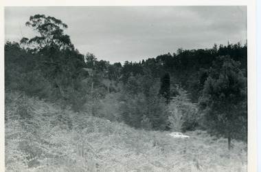
Photograph, View Up Valley Towards Kalorama Gap 1973
John Lundy-Clarke grew up in the Kalorama/Mt Dandenong area and later in life (1972-74) began to write a comprehensive history of the area working from an original settlement map in an effort to cover all areas. This photograph would have been taken to show the changes in the area over the years. Kalorama Gap is now called Five Ways. 'Kia-Ora ' was a guest house built by George Barber. It is no longer standing.Black and white photograph showing a bush scene with a white car visible on the right. Handwritten inscription on reverse by John Lundy-Clarke1973 View up Valley towards Kalorama Gap from what was Crooks LOT 24. White car is on Barbers Road and site of “Kia Ora” is to right of it.kalorama, kalorama gap, five ways, barbers road, george barber, kia-ora -
 Ballarat Tramway Museum
Document - Manuscript, Peter J Barry, "Signalling and Operations on the Tramway System in Bendigo", April 1990
Draft of an article with notes/additions by Keith Kiings on the signalling system and tramcar operations in Bendigo. Looks at the basic services, crossing loops, signalling, following movements (Bendigo used a white disc on the tram to indicate a following tram, Ballarat did not use this system), short workings, reversals, observations of actual workings. Includes a map drawn by Keith Kings in 1972. Published in the September 1990 issue of Somersault, by the Signalling Record Society of Victoria.Yields information about the operation of the Bendigo tramway system using the Forest City Signalling system.Six A4 pages of a draft of an article by Peter Barry and correspondence to Keith Kings re "Signalling and Operations on the Tramway System in Bendigo, April 1990.tramways, trams, bendigo, signalling, forest city, operations, crossing loops, srsv -
 Ballarat Tramway Museum
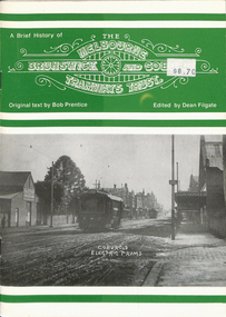
Book, Dean Filgate, "A Brief History of The Melbourne Brunswick and Coburg Tramways Trust", 1999
Book - titled "A Brief History of The Melbourne Brunswick and Coburg Tramways Trust", MBCTT, written by Bob Prentice and edited by Dean Filgate. Published by Tramway Publications 1999. Provides details on the formation of the Trust, appointments, financials, track and overhead construction, power supply, street lighting, depot and offices, opening, map, tickets, staff, operation statistics, extensions, and rolling stock. Illustrated with many photographs including a photograph of the Trust Tramways Band.Yields information about the tramways built by "The Melbourne Brunswick and Coburg Tramways Trust"Book - 24 pages including heavy card covers, titled "A Brief History of The Melbourne Brunswick and Coburg Tramways Trust", centre stapled.trams, tramways, mbctt, tramways band, coburg, construction -
 Federation University Historical Collection
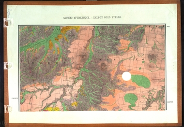
Map, Clunes, Mt Greenock, and Talbot Gold Fields, 1883, 1883
A geological plan of the Clunes, Mt Greenock, and Talbot Gold Fields in two parts. .1) This section of the map includes Talbot, Talbot water supply race, Mt Glasgow, Little Green Hill, Middle Hill, Mt Cameron, Ballarat Hill, Bakery Hill, Goodwoman Hill, Scandanavian Lead, Eglinton Swamp, McCallum's Creek, Tullaroop Creek, Dunach, Maryborough Railway, Middle Creek and includes many mines such as Rip Van Winkel, Union Extended, South Greenock, Nicholl's Freehold. .2) This section of the map includes McCallums, Clunes, Green Hill, Mt Beckworth, Mt Gap, Maryborough Reservoir, and includes mines such as Lothair, Bute, Clyde, Clunes Consols, London and Australian, Oriental,clunes, talbot, water supply, railway, geology -
 Whitehorse Historical Society Inc.
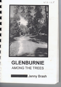
Book, Glenburnie among the trees, 1997
History of Glenburnie Road, VermontHistory of Glenburnie Road, Vermont prepared by Jenny Brash, 1997. Includes a brief history of Vermont with maps of the area. Mentioned are gold mining, orchards, farming and the tile factories. Visits by gypsies. The flora of the area. The establishment of Bloom Reserve and Hales Park, the Kirkpatrick Homes and the Vermont Elderley People's Homes. People mentioned include Paton 1940-53, Hamilton ca 1935, Brereton ca 1937-70, Tovey ca 1930-60, Rawson 1943-, Palmer 1937-, Ken Hauser 1956-, Kirkpatrick 1924-68, Hale 1946-, Esme White, Tom and Pat Fagetter, Francis Hall 1924-, Leonard Uren 1922- (Farley Green Estate). 33 pages, photographs, maps.History of Glenburnie Road, Vermont glenburnie road, vermont, brash, jenny, bloom reserve, hales park, native plants -
 Melbourne Tram Museum
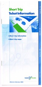
Pamphlet, Yarra Trams, "Short Trip Ticket Information", Feb. 2003
Booklet - 16 pages, center stapled with route tabs, printed in colour on gloss paper, titled "Short Trip Ticket Information", effective Feb. 2003. Outlines the use of Yarra Tram's short trip tickets on the tramway system, and gives details of 7 routes and section details with a map at the time. Second copy added 23-10-15 from Yarra Trams donation. .1 - 12 pages, centre stapled, printed on white paper, titled "Short Trip Tickets", giving information for routes 11, 12, 48, 70, 75, 86, 96, and 109. Has a map for each route and trip information, Metcards. C2001, prior the amalgamation of Yarra and M>Tram.trams, tramways, the met, short trip tickets, tickets, instructions, yarra trams, route 12, route 11, route 48, route 70, route 75, route 86, route 96, route 109 -
 Melbourne Tram Museum
Pamphlet, Public Transport Corporation (PTC), "Free City Circle Tram", mid 1990's
Pamphlet - eight fold to DL size, full colour, titled "Free City Circle Tram" with a photo of a City Circle tram passing Flinders St station. Has information about Melbourne trams, the Melbourne Town Hall, Visitor Information, Walking Trails, a map of the route, with places of interest shown. Map shows the service via Spencer St. Has photos of 2013 and 909 as well. Has the City of Melbourne, Department of Infrastructure and Public Transport Corporation logos. Possible produced during the mid 1990's given the various logos used. .1 - As above, but with Yarra Trams and State Government logos See Reg Items 1387 and 2703 for other versions.trams, tramways, city circle, melbourne, public transport corporation, ptc -
 Ringwood and District Historical Society
Document - Real Estate Folder, Savernake Estate, Ringwood, Victoria - Stage two - circa 1967
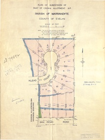
Plan of Subdivision PS79692, Part of Crown Allotment 31A Parish of Warrandyte, and advertisement for sale of residential allotments with map showing layout of Stage 2 of subdivision. Typewritten details for first and second release of Lots 10 to 16 with Terms of sale, stapled to two advertising flyers featuring map of estate showing Lots 1 to 20 on Evelyn Road, Cameron Road, Klead Court, and San Remo Road. Green slip included dated 6 July 1979 showing description of property at Lot 14 (no.4) San Remo Road, vendor - Judith Margaret Love and Lindsale Stephen Love, Cherry Tree Downs, Tarwin Lower 3456. Phone 056635390 Bus 056787203.Agent - C.E. Carter & Son, R.E.S.I. 126 Whitehorse Road, Ringwood. Telephones: 8706024, 8706830, 8702519, A.H.: 7233298, 8782648. Subdivision Plan stamped Donald Cameron Consultants Pty. Ltd., Consulting Engineers, 472 Bourke Street Melbourne - 67-2602. -
 Bendigo Historical Society Inc.
Document - MCCOLL, RANKIN AND STANISTREET COLLECTION: INDENTURE GOLD MINING LEASE 11012 CROWN AND NORTH DEBORAH MINING COMPANY, 3rd June to 13th Nov 1939
6 page document plus map: indenture No. 11012, Gold Mining Lease, between Crown and North Deborah Mining Company carrying on operations in the Parish of Sandhurst, dated 3rd June, 1939. Map shows land excised for mining in pink and Crown land in orange cross-hatching . Streets shown: Queen Street, King Street, Hargreaves Street, Breen Street. Leases: No's. 10939, 1363 TL, 11012, 10937, Railway line through centre of lease holding. On last page 'Deborah Gold Mines No Liability of 125 queen Street Melbourne is now the proprietor of the within described estate by transfer registered on 13th November, 1939 and numbered 1752584'.bendigo, mining, north deborah mining company, j sweeney, common seal of north deborah mining company, stanistreet, breen street, king street, queen street, hargreaves street. -
Ringwood and District Historical Society
Pamphlets, Council Annual Reports, 1956 to Ringwood Ratepayers and 1976 to Citizens of Ringwood, and Invitation to Maroondah Trade and Industry Development Group Luncheon, 1974, 1. 25-Oct-1974|2. Jan 1956|3. 3-Nov-1976
Three pamphlets relating to Ringwood's Development and notices to ratepayers.1. Invitation. Orange coloured bifold with black printing; 2. Report. White four page foolscap. Black printing. Borough Crest on front page.; 3. Report. Cream bifold with blue printing. Map with 5 photos. +Additional Keywords: Kelly, Alfred (Town Clerk) / Smart G.R.B. (Mayor)1.Trade and Industry development group - Maroondah.; 2. Ringwood Council Annual Report to the ratepayers.; 3. A report to the citizens of Ringwood. -
 Warrnambool and District Historical Society Inc.
Book, Warrnambool Standard Almanac 1929, 1929
This booklet was given to subscribers to the Warrnambool Standard newspaper as an almanac for the year 1929. Warrnambool Standard Almanacs were produced annually from 1875 to 1930. They contain much local information on Warrnambool and district about the businesses, government officials, banks, churches, schools, harbour management, societies and organizations etc. The Warrnambool Standard newspaper was established in 1872 and continues to this day. This booklet is of high significance as it contains much valuable information on Warrnambool and district for the year 1929. It is an important resource tool for those studying and writing the history of Warrnambool and district. This is a booklet of 100 pages. The cover and several pages at the back and the front of the booklet are missing. The booklet is bound with metal staples. The booklet has a fold-out map of Warrnambool printed in green, several photographs printed in black and white and others in brown and blue tonings and other illustrations. The booklet is splotched and stained throughout. warrnambool standard newspaper, standard almanac 1929 -
 Kiewa Valley Historical Society
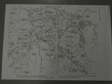
Maps - Squatting Runs of the Murray District 1848 x2, July 26,1848
The Port Phillip Gazette was the second newspaper published in Melbourne, in the then Port Phillip district, now Victoria. In 1948 it was published bi-weekly.The map shows the original names of squatters along the Kiewa River. The names of the district are mostly current today although some are spelt differently.2 copies - 1 laminated & 1 paper of the map of "Squatting Runs of the Murray District 1848." The area is recorded (eg. Tawanga, Dederang, Gundowring, Kergunia, Merrimarenbung all along the Kiewa River) under which the names of the squatter is recorded, the number of acres and the licence number. Scale is 8 miles to the inch.squatting runs; kiewa valley; port phillip district; -
 Warrnambool and District Historical Society Inc.
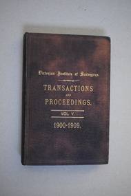
Book, Victorian Institute of Surveyors Transactions and Proceedings Vol V, 1910
This book belonged to John William Crawley, Junior who had acquired it in 1910 as a member of the Victorian Institute of Surveyors. John Crawley was an engineer, architect and surveyor in private practice in Warrnambool and also the official engineer of the Shire of Warrnambool from 1896 to 1935. His father, brother and son were also engineers and worked in that capacity for the Shire of Warrnambool or as the Shire Secretary, with the Crawley family members recording a total of 132 years of service to the Shire of Warrnambool which existed from 1863 to 1994. This book is retained as it belonged to John Crawley, the engineer for the Shire of Warrnambool for forty years. This is a hard cover book with a dark brown cover with gold printing on the front cover and spine. The cover is now stained. The book contains an introduction, twenty papers and reports from 1905 to 1910. There are many black and white photographs and fold-out maps and plans. The signature on the second page is handwritten in black ink. J.W.Crawley W’bool 26.3.10crawley family, warrnambool, shire of warrnambool, history of warrnambool -
 Eltham District Historical Society Inc
Booklet - Folder, History of Eltham Primary School, 1970
History of Eltham Primary School to 1970Photocopy of original book: History of the Eltham Primary School, published in 1970. 14 pages. 3 Photocopies of parts of map Handwritten notes by H.G. about walking to school and early classroom conditons and activiites Writings by Grade 1 students of EPS "about what life was like 150 years ago"eltham primary school, adamson, armstrong, atkinson, betti, blackman, brown, buchanan, caldwell, clark, cochrane, coleman, curran, daply, dudfield, dunne, dunstan, elliott, findlay, fisher, gamble, gardiner, gardner, gilchrist, gray, greenwood, haniford, harry gilham collection, hughes, hunniford, jobling, kane, kaylock, kewish, lancaster, main, mccoll, mcmurrey, mcolvan, meadow, meadows, murray, murrey, orlebar, overman, pearson, peerson, potter, scott, sincom, son, spicer, state school no. 209, stewart, sweeney, teague, unsworth, warren, williams -
 Nhill Aviation Heritage Centre
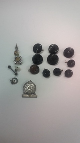
Buttons, Variety of airforce buttons
These buttons and badges belonged to Frank Seddon, an airforce pilot during World War 11, father of Nhill resident Pat Beacom.5 black 25 mm diameter buttons and 4 black 17mm diameter buttons with crown and eagle logo. RSL lapel badge , and RSL pin badge. Brown Australian Military Forces button 20 mm diameter, with crown and map of Australia inscribed on it 2 smaller slightly damaged buttons. airforce, buttons, seddon, wwii, ww2 -
 Bendigo Military Museum
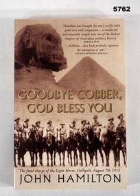
Book - BOOK - Gallipoli WW1, John HAMILTON, "Goodbye Cobber, God Bless You.", 2004/ 2005
"GOODBYE COBBER, / GOD BLESS YOU." "The Fatal charge of the Light Horse, Gallipoli, August 7th 1915."Soft cover book. Cover - cardboard. Gold, dark brown and light brown print on front, spine and back. Front cover - Illustrated sepia tones photographs of scenery and a group of Light Hors soldiers. 365 pages - cut, plain, off white paper. Illustrated black and white photographs and maps.books, military history, ww1, gallipoli peninsula -
 Bendigo Military Museum
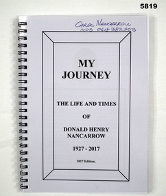
Book - AUTOBIOGRAPHY, BCOF, Donald Henry NANCARROW, “MY JOURNEY’, 2017
“MY JOURNEY’ ‘ THE LIFE AND TIMES/ OF DONALD HENRY NANCARROW/ 1927-2017” 2nd AIF Service No VX 96723. Enlisted 21 March 1945. AWOL. To Japan- age 19 years March 1946. “Tour of Duty” in Japan ended September 1947. Discharged 9 October 1947Soft cover book Cover- front clear hard plastic, back black cardboard, metal spiral bound. Title page - black print on white paper 97 Pages- cut, plain white paper. Illustrated black and white and colour photographs and maps Title Page- handwritten donors name Title Page- handwritten donors name- blue pen “ Carol NANCARROW/ Mob 0418 382 503books, military history, ww2, bcof, japan -
 Bendigo Military Museum
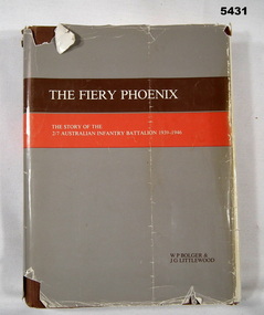
Book - BOOK, UNIT HISTORY, 2/7th Bn Association, The Fiery Phoenix. The Story of the 2/7 Australian Infantry Battalion 1939-1946, Post WW2
Item in the collection relating to John Eric Wiles, refer Cat No 5410P for his service details.Book hard cover brown buckram, paper dust jacket with brown over red with “The Fiery Phoenix” at the top in the brown stripe, 442 pages plus other, photos, maps, nominal roll, honours and awards lists of POW’s, KIA & WIA. Written by W. P. Bolger & J.G. Little wood.On inside cover on typed paper stuck in, “J.E. Wiles 2/7th INF BN VX16067”books, 2/7th, unit, wiles -
 Bendigo Military Museum
Book - BOOK, BIOGRAPHY, Author " Stanley A. Hawkens O.B.E", Missing, Presumed Dead, 1989
Soft cover book. Cover- cardboard, red , black and white on front, spine and back. Illustrated- front sepia tones half portrait photograph of an airman in uniform superimposed over handwriting in a frame. 209 pages, plain cut, off white. Illustrated black and white photographs and maps. Language - EnglishTitle page. handwritten blue ink - "To my wonderful friends/Bertha& Bob/ Stan Hawken/ 18.4.89"books, raaf, ww2 -
 Bendigo Military Museum
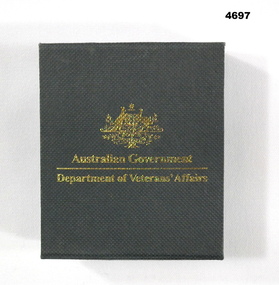
Memorabilia - MEDALLION, BOXED, Department of veterans Affairs, C.2005
Issued to Roy Thurlow, refer Cat No 4688P.1) Box cardboard black, folding lid with gold lettering on front with gold Coat of Arms, gold lettering on inside of lid. .2) Medallion round gold colour, front has coat of arms with lettering, rear has depiction of map of Australia with large number “60” plus smaller print..1) On front, “Australian Government Department of veterans Affairs”, inside has “60th Anniversary f the end of World War 11, For Service Australia” .2) On front, “World war 11, Service to Australia”, on rear, “World War 11, 60 years, Service to Australia”.memorabillia, medallions, 60th anniversary