Showing 123771 items matching "main-road"
-
 Kiewa Valley Historical Society
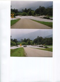
Photos - x2 Damms Road River Crossing
Damms Road river crossing after the c1993 floods of the Kiewa River. The old bridge was inundated, later to be washed away.The Kiewa River flooded in 1993 at Damms Road when the old bridge was washed away.2 coloured photos of the Kiewa River in flood at Damms Roadkiewa river flooding, bridge at damms road -
 City of Kingston
Pamphlet - Colour, Brock Bros, South Brighton Township Estate, 1888
Sales plan for land in the suburb of South Brighton (Moorabbin), bounded by Point Nepean Road, South Road, Patterson Street and the Mordialloc Railway Line. Incorporates Wolsely Street and Gordon StreetThe developing urban area of Moorabbin within the City of Kingston. This land sale pamphlet illustrates the subdivision of land within the municipality and the changing demographic of the district as new houses are constructed close to infrastructure.Colour pamphlet advertising for private sale the South Brighton Township Estate, South Brighton. Incorporates a map of the estate bordered by Point Nepean Road, South Road, Patterson Street, and the Mordialloc Railway Line. Includes Wolsley Street and Gordon Street. land sales, south brighton, estate, moorabbin -
 Vision Australia
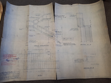
Plan - Image, Section B.B (stairwell), 12/5/1977
Architectural drawing for the completion of a outside stairway at St Kilda Road. Detailed drawing of the stairs, including specifications and measurements and shows the front elevation and two sections.1 architectural plan of stairwell at St Kilda RoadCraftsteel Industries Pty Ltdroyal victorian institute for the blind, plans -
 Melbourne Tram Museum
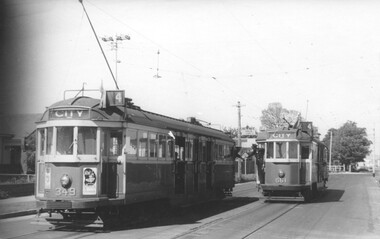
Photograph - Black and White - Trams 349 & 661, Truganini Road Carnegie, John Alfred
Photo shows W2 349 and W3 661 in Glenhuntly Road / Truganini Road Carnegie (route 4) at the start of the single line to the terminus, with the drivers "exchanging the staff" for the section. The destination of 349 has already been changed. Note the warning sign above the drivers of the Single line section. Photo possibly 1950s.Yields information about the use of the short single line just before the Carnegie terminus.Photograph - Black and White - Trams 349 & 661, Truganini Road CarnegieHas details on rear in ink and John Alfred Stamp.tramways, tramcars, carnegie, truganini road, single line, staff, w2 class, w3 class, tram 661, tram 349, glenhuntly road -
 Whitehorse Historical Society Inc.
Document, History of Tally Ho Boys Home, 1972
Three papers on History of Boys Training Farm, Highbury Road, Tally Ho3 papers on History of Boys Training Farm, Highbury Road, Tally Ho, commenced in 1903 by Rev. and Mrs George Cole. The story covers the period from 1903-1930. The farm was built on land bought from Abel Hoadley for 1,000 Pounds near the corner of Springvale Road in Boundary Road (now Highbury Road). 2 letters (16/7/1972 & 28/5/1972) to Nancy Leach from E. Hinneberg, Assistant Superintendent, Tally Ho, about his association with Tally Ho.Three papers on History of Boys Training Farm, Highbury Road, Tally Hoyouth services, tally ho boys home, cole, george, rev., cole, mrs, hoadley, abel, boundary road burwood east, highbury road, burwood east, springvale road, burwood east, leach, nancy, hinneberg, ernest. -
 Kew Historical Society Inc
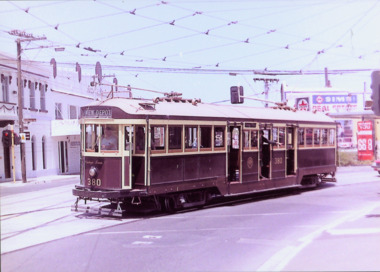
Photograph - W Class 380 turning out of Barkers Road into High Street South, 1990
This colour photograph, with 15 others are enlargements gifted to the Society by Mel Lawrence in 2016. They were taken at a commemorative event from the Kew Tram Depot. Laminated colour enlargement of W Class tram No.380 turning out of Barkers Road into High Street South, during a re-enactment in 1990.Annotation reverse: "Kew Depot 1990. W Class 380 turning out of Barkers Road into High Street South"kew tram depot, trams -- melbourne, a class trams -
 Tarnagulla History Archive
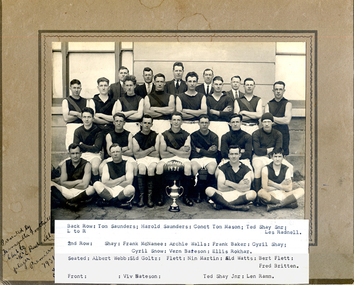
Tarnagulla Football Club Premiership team 1931 (Radnell copy), Tarnagulla Football Club Premiership team 1931, 1931
Murray Comrie Collection. The players are posed in front of Tarnagulla Town Hall (later known as Burstall Hall) in the main street of Tarnagulla. The building has since been demolished. Mens football team posed in four lines in front of large building. All are wearing black tops and white shorts. Man at centre front is holding a football on which is painted PREMIER 1931. Taken in front of Tarnagulla Mechanics' Institute, formerly the Borough of Tarnagulla Council Chambers, and later known as Burstall Hall. Demolished c1980."Presented by Tarnagulla Football Club to H.E. Radnell player Premiers 1931". Player names listed in piece of paper adhered to photograph.tarnagulla, sport, football, radnell, mcnamee -
 Tarnagulla History Archive
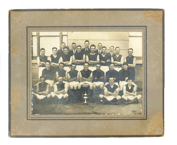
Tarnagulla Football Club Premiership team 1931 (Williams copy), Tarnagulla Football Club Premiership team 1931, 1931
Murray Comrie Collection. The players are posed in front of Tarnagulla Town Hall (also known as Burstall Hall) in the main street of Tarnagulla. The building has since been demolished.Mens football team posed in four lines in front of large building. All are wearing black tops and white shorts. Man at centre front is holding a football on which is painted PREMIER 1931. Probably taken in front of Tarnagulla Town Hall otherwise known as Burstall Hall (now demolished).Names of subjects and name 'L.Williams' handwritten on reverse.tarnagulla, sport, football, radnell, mcnamee -
Glen Eira Historical Society
Document - GARDENVALE ROAD, 77, GARDENVALE
This file contains research by the Brighton Historical Society into this property: 1/A photocopy of a typed document describing the history of the property at 77 Gardenvale Road, with a brief history of Gardenvale, including the impact of the building of Gardenvale Station in 1906 and the railway underpass in 1927. Before the station was built, the area had many market gardens, many of which were sub-divided after the station was built. Includes a list of past owners/residents of 77 Gardenvale Road (previously number 49). 2/Also includes a carbon copy of this document which is faded. 3/Handwritten notes covering mostly same information. By Hilary Bullock and Rosalind Landells of the Birghton Historical Society, printed on 22 July, 1987.market gardens, railway lines, gardenvale station, gardenvale road, o’neill family, chinese community, lempriere’s paddock, martin street, judd frederick, drayton me, agg george, agg family, agg mary, agg winifred, agg fanny, railway stations, macaulay misses, gardenvale -
Glen Eira Historical Society
Document - Glen Huntly Fire Station
This folder contains 3 copies of photographs plus notes about the Glen Huntly Fire Station: 1/A print of a small black and white photograph (95mm x 127mm) of the exterior of Glen Huntly Fire Station accompanied by typed notes sourced 13/03/2007 from the Melbourne Fire Brigade Museum. The notes indicate that the fire engine shown parked out the front was in service 1919 to circa 1924: Car 55 Rego 8499 Hose Carriage Engine No. 3178 Napier. 2/An A4 sepia copy of the same photograph (210mm x 291mm) with street advertising of one of the shops clearly visible: 'DRAPERY EMPORIUM. UNDERCLOTHING BABY LINEN; HOSIERY HABERDASHERY MILLINERY'. The electric tram at the terminus on Grange Road is also seen in the photograph. Noted on the reverse of the photo: 'Glen Huntly Road and Grange Road' in pencil. 3/A photocopy of a black and white photograph (154mm x 200mm) of Fire Engine with No. 13197 outside the Glen Huntly Fire Station. Two firefighters are seated in the carriage and three others stand on the running board. It is noted 'D DISTRICT' at the top and 'No. 29 STATION GLENHUNTLY' on the bottom.glenhuntly, glen huntly fire station, glen huntly road, glenhuntly road, grange road, eastern hill fire station, electric trams, metropolitan fire brigade board, fire stations, fire brigades, fire engines, firefighters, firefighting equipment, hose carriage engine no 3178 napier, glen huntly, melbourne fire brigade museum, russell david -
 City of Moorabbin Historical Society (Operating the Box Cottage Museum)
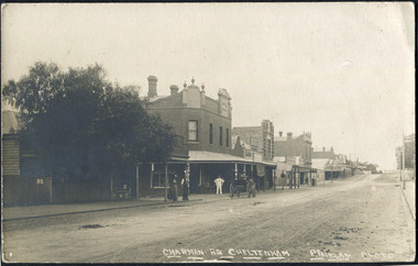
Photographs , Postcards x4 Charman Rd Cheltenham c 1910, c1910
After the arrival of the Cheltenham Railyway Station Charman Road became the main shopping centre. From 1 small shop - Mrs Meeres who sold sweets, school requisites and drapery - it proceeded to develop throughout the 1890's with various traders until the 1910 Postcards show many shops on both sides of the road, Stephen Charman, aged 21years, arrived in Melbourne in 1842 as one of Henry Dendy's Emigrants. 1852 he purchased 160 acres for £328 bounded by Charman Rd and Balcome Rd. 'The Spring' was an important water source for the local Aboriginal people and then for the early settlers. Charman's first wife Harriet and their infant child died and in 1850 he married a widow with 5 children, Mary Gettens. Their first home was made of wattle and daub and they had 7 more children. Later a weatherboard cottage was built c 1855 Together they developed a market garden and specialized in marigolds which were sold for medicinal purposes to the Melbourne Chemists - Martin & Pleasance . The first Methodist Church Services were held at Spring Grove and the Charmans donated land in 1857 for the first Chapel, Cemetery and Primary School . Mary died 1870 and Stephen married again and moved to Gippsland where he died aged 85 in 1906 Stephen and Mary Charman were pioneer market gardeners in Moorabbin Shire 1842 and were involved in the development of Church, school and community in the area now called Cheltenham. Charman Road Cheltenham was a boundary of their land.4x Black & White Postcards c 1910 of Charman Road Cheltenham VictoriaFront; CHARMAN RD. CHELTENHAM P. FAIRLAM PHOTOfairlam p, cheltenham railway station, moorabbin, cheltenham, dendy henry, dendy's special survey 1841, assisted emigrants early settlers, pioneers, market gardeners, marigold flowers, pharmacy, charman stephen, gettens mary, charman harriet, methodist church, primitive methodists, box william, box elizabeth, state schools, education, moorabbin shire, moorabbin roads board, city of moorabbin, kingston city council, cancel, cheltenham primary school -
 Clunes Museum
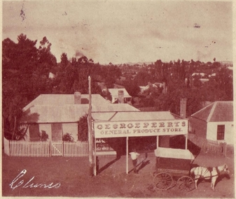
Photograph, PURCELL, ROGER, COPIES 1996
GEORGE PERRY'S GENERAL STORE WAS SITUATED IN CRESWICK ROAD. CLUNES, PRESENT SITE OF THE LATE BRENDA TREMBATH 'S HOUSE..1 ORIGINAL SEPIA POSTCARD PHOTOGRAPH OF GEORGE PERRY'S GENERAL PRODUCE STORE IN CRESWICK ROAD, CLUNES POSTAGE STAMP AFFIXED, ONE PENNY .2.3 BLACK AND WHITE COPIES OF THE ABOVE PHOTOGRAPH PRINTED ON GLOSS PHOTOGRAPHIC PAPER .4.5.6 BLACK AND WHITE COPIES OF THE ABOVE PHOTOGRAPH PRINTED ON MATTE PHOTOGRAPHIC PAPER .7 Supplementary FileAddressed to; Mrs. Perry Creswick Road, Clunes Postmarked Jan 15 1907 Handwritten date 12/1/07 "Dear Grandma, I am sending you a post card view of your shop that Dada took. I hope you will like it and trust you are well, Muriel" (Written in black ink) local history, photography, photographs, shops george perry's general store, buildings -
Glen Eira Historical Society
Article - Shoobra Road, 63, Elsternwick
3 items on 63 Shoobra Road: 1/An advertising article dated 19/03/2004, from Property Review Weekly, giving details of original features and renovations done to 63 Shoobra Road, for forthcoming auction by Gary Peer. 2/Handwritten research by Claire Barton on 63 Shoobra Road giving house name in the 1910 Sands & McDougalls and owner/tenant, dated 30/09/2011. 3/An auction advertisement for 63 Shoobra Road on 06/12/2014 (newspaper add hand-dated as 11/11/2014).shoobra road, real estate agents, house names, elsternwick, wymswold, verandahs, street charles, fireplaces, architectural features, cast iron work, marble, gary peer & associates, stables, bay windows, carports -
 Surrey Hills Historical Society Collection
Photograph, Fred Lyons and his son Arthur after a hail storm, 1924, 1924
Lyons family history: Frederick Adolphus (Fred) Lyons operated a cab / taxi service in Union Road for several decades. Arthur was the only son of Frederick Adolphus Lyons (1891-1980) who was born in Surrey Hills, son of Thomas and Catherine Lyons. He married Elizabeth Ruby Hall in 1918. They lived at 55 Sunbury Crescent. The Lyons’ home was called ‘Knopshambury’ - this was probably a misspelling of Knockshanbally in Co Kilkenny, the birth place of Fred’s father, Thomas Edmund Josias Lyons (1846-1915).Arthur Lyons was born in Surrey Hills on 12 Jun 1920. He became a motor mechanic / welder and lived his whole life at 55 Sunbury Crescent. This is one of a series of photos donated by Arthur Lyons. The donation was made while he was in hospital. He died shortly afterwards (23 Sep 1990). Donation was finalised by a neighbour, Mrs Florence Ann Armitstead, wife of Glen Victor Armitstead. Glen was a local hairdresser. They moved to 11 Sunbury Crescent after their marriage in 1939. Arthur had no relatives to distribute the material to. The hail storm occurred on 2 December 1924.Despite the poor condition, this is significant because of the clear detail of the Union Road buildings and railway crossing in the background in 1924.Black and white photo of cab driver Fred Lyons with his son Arthur taken at the cab rank near the Surrey Hills station, clearing up after a hail storm in 1924. Fred balances 2 large shovels; Arthur has an over-sized jacket on. The railway gates and overhead lines can be clearly seen in the background. Despite the poor condition, it is a relatively significant photo as it details Union Road buildings and the railway crossing clearly behind it.On back of photo is written in pencil "copied 1996" and in blue pen "2/12/24"railway crossings, hail storms, frederick adolphus lyons, fred lyons, arthur frederick lyons, arthur lyons -
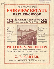 Ringwood and District Historical Society
Flyer, Land Sale Brochure, Fairview Estate, East Ringwood, Vic. - circa 1925
Bi-folded single sheet advertisement for private sale of residential allotments, including subdivision features and local facilitiesSudivision includes Eastfield Road, Margaret Street and Patterson Street. Local Agent - C.E. Carter, Bank Chambers, Main St., Ringwood. Tel. Ringwood 24. -
Port Melbourne Historical & Preservation Society
Plan - Detail of Grille and Stairs, Port Melbourne Town Hall, Port Melbourne City Council, 1916
Plan - Details of grille to entrance and over main stair, details of main stairs. (1915 Town Hall)port melbourne town hall -
Glen Eira Historical Society
Letter - St. Georges Road, 12, Elsternwick
A Letter To The Residents Of St. Georges Road Regarding The Filming To Take Place At 12 St. Georges Road On 6/9 And Betweek 9/9 and 13/9. The Letter Is Undated And Signed By Harrison, Jennie.abc, television stations, street angels, st. georges road, entertainment, elsternwick, harrison jennie -
Whitehorse Historical Society Inc.
Document, Gallus Family, 1851-1976
Gallus family history in Vermont.Gallus family history in Vermont. They owned a poultry farm on the corner of Boronia and Centre RoadsGallus family history in Vermont.gallus, e.e, gallus, dianne, gallus, cynthia, poultry farms -
 Whitehorse Historical Society Inc.
Photograph, View from Mitcham Pedestrian Bridge, 1/07/2000 12:00:00 AM
Coloured view from pedestrian overpass on Whitehorse Road, looking towards Mitcham right (south) side. Cars parked front into gutter in mid ground are parked in front of St Johns Catholic Church.mitcham, whitehorse road -
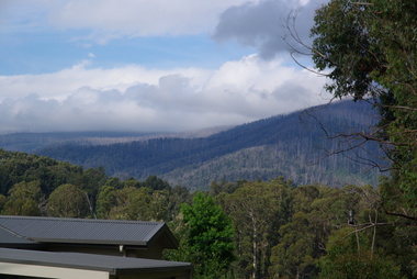 Ballarat Heritage Services
Photograph - Colour, Clare Gervasoni, Regrowth after the 'Black Saturday' Bushfire, 2012, 15/12/2012
A number of colour photographs showing regrowth on Eucalypts from Kings Road, Marysville. The trees had been subject to a hot burn during the 2009 'Black Saturday' bushfire. A newly constructed house is in the foreground.bushfire, black saturday, marysville, kings road -
 City of Kingston
Photograph - Black and white, c. 1970
This photograph depicts the steel tramway (or tram plate) along Centre Dandenong Road, Cheltenham near the Moorabbin Airport entrance in the 1970's. These tramways played an important role in transportation along Moorabbin's major roads. Heavily laden carts could travel smoothly and safely along the steel plates when the road surfaces were often rutted and hazardous. This surviving section was later moved for road improvements. The area now known as the City of Kingston was a market garden region and the round trip to market could take as long as eight hours on poorly maintained roads. The installation of the steel tramway transformed the arduous journey faced by market gardeners in transporting their produce to market. As there was only a single tramway, the carts often travelled in convoy, enabling drivers to leave piloting to the first cart and having a rest. The rails did not speed the journey to the city, but it smoothed progress immeasurably. Black and white photograph of steel tram plates on Centre Dandenong Road, Cheltenham. The road is sealed. At the top of the image there are trees behind a parked car which is adjacent to a white shelter. There is a large sign stating MOORABBIN AIRPORT above an arrow pointing to the right in the top centre of the image. Handwritten in pencil: A 28 / [indecipherable] 3 / [indecipherable] Handwritten in red ink: A28 / 70%market gardening, infrastructure, transport, steel tramway, industry, moorabbin -
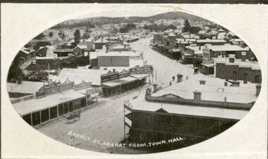 Ararat & District Historical Society (operating the Langi Morgala Museum)
Postcard
Black and white postcard of Barkly Street, Ararat. The photo is taken from the Town Hall. The Commercial Hotel and its balcony are pictured on the right while the zig zag of the main street looks like a dirt road.Addressed to Mr G. Mitchell, Collins St, Melbourne also a letter written on the back of the postcard -
Whitehorse Historical Society Inc.
Map, Facilities provided for you, 1970
Map of the City of Nunawading showing main roads and reserves with numbers indicating location of Halls, Infant Welfare Centres, Elderly Citizens Clubrooms and other major Council facilities. Route of proposes Healesville Freeway marked.Map of the City of Nunawading showing main roads and reserves with numbers indicating location of Halls, Infant Welfare Centres, Elderly Citizens Clubrooms and other major Council facilities. Route of proposes Healesville Freeway marked.Map of the City of Nunawading showing main roads and reserves with numbers indicating location of Halls, Infant Welfare Centres, Elderly Citizens Clubrooms and other major Council facilities. Route of proposes Healesville Freeway marked.city of nunawading, maps, maternal and child health centres, senior citizens centres, healesville freeway, parks and reserves -
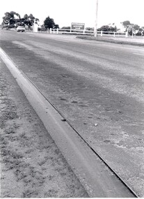
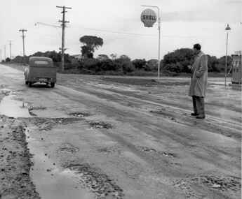 City of Kingston
Photograph - Black and white, c. 1950
This image depicts the unsealed roads with potholes prevalent in the quickly developing suburbs of Black Rock and Beaumaris. In the post war era, as the suburbs of Beaumaris and Black Rock grew, the infrastructure for roads was falling behind. The unsealed roads were dusty in summer and muddy with potholes in winter. Drainage was poor and roads difficult to navigate.Black and white photograph of a man standing outside the Shell service station in Balcombe Road, possibly at Beaumaris. He is watching a utility vehicle with registration GFM033 as it drives on the unsealed road through mud and potholes.Handwritten in blue ink: 2195 Handwritten in red ink: 80%roads, infrastructure, beaumaris, black rock, balcombe road -
Glen Eira Historical Society
Document - Malonga
Typed notes on the Thompson family, supplied by Sue Samuel, undated, also giving a brief history of the construction of Malonga, Dandenong Road, Caulfield. Also included are handwrittem research notes, undated and unattributed, listing the previous owners of Malonga rangingfrom its construction in 1891/1892 to 1939.samuel sue, grosmont, caulfield north, thompson walter, malonga, kooyong road, wallace elizabeth, dundee marmalade, jameson william, thompson elizabeth, ogilive john captain., mcleod james. a., keillerin james, dandenong road, mcleod mrs -
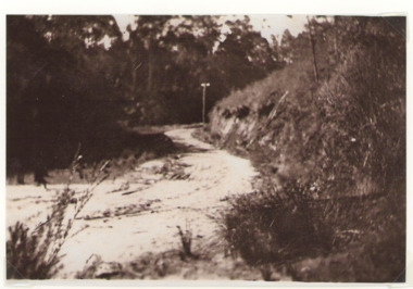 Lakes Entrance Historical Society
Photograph - Old Bungs Rd. 1927, c1927
This was the old coach road to Orbost which went from Lakes Entrance to Orbost via Lake Tyers.Black and White photograph of old Bunga Road crossing, Lake Tyers.roads and streets, development -
Glen Eira Historical Society
Map - Kooyong Road, Caulfield North
A sepia photograph of Kooyong Road (61 x 87mm) undated and unattributed. Accompanied by an undated, unattributed handrawn map of road (42mm x 87mm) and explanatory handwritten notes detailing what is depicted in the photograph: looking towards a field and church at the intersection of Kooyong and Glen Eira Roads. Map and handwritten explanatory notes have been photocopied from the back of one sepia photograph.kooyong road, glen eira road, derby parade, brighton road, caulfield north -
Lakes Entrance Historical Society
Financial record - Ledger, Country Roads Board Wages Ledger, 1953
A Ledger of Wages paid to Country Roads Board employees of East Gippsland VictoriaA Ledger of Wages paid to Country Roads Board employees of East Gippsland Victoriaaccounts book -
 Melbourne Legacy
Photograph, Harelands, 9/9/1963
The Harelands property in Kew, was used as a residence for Junior Legatees (Legacy Beneficaries) up to the age of 14 years. It operated during the 1960’s and 1970’s.Melbourne Legacy established residences to aid children of deceased servicemen complete their education, take further education and find employment.Black and white photo of Harelands, Willsmere Road, Kew. Handwritten 'Harelands 1963 Willsmere Road, Kew up to 14 year-olds Residence for Junior Legatees'. Stamped 'Property of Melbourne Legacy' in purple ink. Stamped with photographers details and order number (P2976/7) and date (9/9/63).harelands, residences, properties -
Glen Eira Historical Society
Plan - Centre Road, Bentleigh
Two copies of a one page printed advertisement for the auction of six shops on Centre Road, Bentleigh near Jasper Road to be held on 07/03/1950. The advertisement includes a plan (51mm x 127mm) of the sitesmeldrum w, centre road, bentleigh, plans, advertisements