Showing 3220 items
matching road map
-
 Kiewa Valley Historical Society
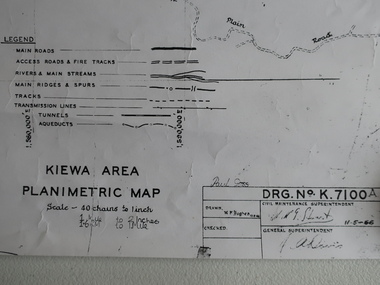
Map - Kiewa Area Planimetric Map
Planimetric maps are two-dimensional representations of the Earth's surface, showing the location and spatial arrangement of features such as roads, buildings, and bodies of water.A very clear map showing the Kiewa Hydro Electric Scheme in two dimensions to include the construction done by the SECV.Black and white Map of the Kiewa Area from Mt Beauty to the High Plains covering the Kiewa Hydro Electric Scheme and surrounds. Drawn on 11th May 1966kiewa hydro electric scheme 1966 -
 Kiewa Valley Historical Society
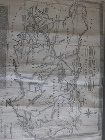
Map of the Ovens and Murray District of Victoria
... Black and white map with references to roads and gold... Black and white map with references to roads and gold ...The map features Beechworth and its history.This map features the north-east and in particular, Beechworth where residents of the Kiewa Valley may have shopped or visited for appointments.Black and white map with references to roads and gold. The centre of the map is Beechworth and in the bottom left side of the map is the heading Beechworth with 12 lines of print of information regarding Beechworth. The Kiewa Valley is not identified.beechworth -
 Kiewa Valley Historical Society
Maps - Kiewa Valley Parish Maps x3 and Kiewa Area Planimetric Map x1
Planimetric maps are 2 dimensional representations of the Earth's surface, showing the location and spatial arrangement of features such as roads, buildings, and bodies of water. The parish maps show the occupiers with leases or licences of the land. These are updated by the Department of Lands regularly. The names of early settlers of the Kiewa Valley occupying land by lease or licence are shown. Many of these familie's descendants still live in the Kiewa Valley.1. Kiewa Area Planimetric Map (photo) 2. Wermatong, County of Bogong Parish Map 3. Mulllindolingong, County of Bogong Parish Map 4. Mullagong, County of Bogong Parish Map All black and white kiewa valley. parish maps. land owners -
 Kiewa Valley Historical Society
Maps 3D - National Parks
Used by the employees of National Parks. The maps show the topography and contours in 3D when used with the stereoscope KVHS 0743. This enables the photographed area to be compared to previous photos and enables the planning of construction of eg. new roads etc. Digital information is now available.These photographs give the topography and contours of vast local areas eg. Mt Feathertop and Tawonga township.when used with a stereoscope. Black and white large aerial photos of the Bogong High Plains area. 14 to 20 of them all on thick paper and the same size as the brown wooden box which holds them. The box hasn't got a lid at the top.Identified and catalogued by National Parksmaps showing topography, national parks, stereoscope -
 Eltham District Historical Society Inc
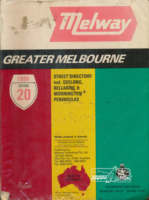
Book, Melway Publishing, Melway Greater Melbourne Street Directory, edition 20, 1990, 1990
... index. streets roads maps melway ISSN 03113957 500 p. : col ...Coloured detailed maps accessed by a street or location index.500 p. : col. maps ; Flexible cover edition with fitted clear plastic jacket.ISSN 03113957streets, roads, maps, melway -
 Eltham District Historical Society Inc
Book, Melway Publishing, Melway Greater Melbourne street directory : including Geelong, Phillip Island, Healesville, Bellarine & Mornington Peninsulas, 2002
... , streets roads melbourne maps melway ISSN 03113957 1 atlas (24, 886 ...Edition 29. Coloured detailed maps accessed by a street or location index. Cover: 20 additional pages of new maps, extended coverage of Bellarine Peninsula, further coverage of Werribee South, Public Transport Information, latest official suburb boundaries, CBD "hook turn" intersections map, over 1200 new streets, 1 atlas (24, 886 p.) : col. maps ; ISSN 03113957streets, roads, melbourne, maps, melway -
 Eltham District Historical Society Inc
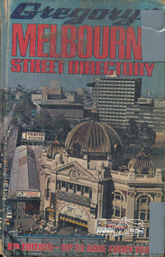
Book, Gregory's Melbourne Street Directory of Melbourne and suburbs and metropolitan road guide (8th edition) extends to Laverton, Deer Park, Epping, Diamond Creek, Lilydale, Olinda, Belgrave, Doveton and Mornington, 1973
... - maps roads Hard copy with plastic cover. 382 p. Gregory's ...This is the 8th edition of Gregory's Melbourne Street Directory, fully revised and up-to-date for this edition published December 1973. It is a comprehensive guide to the streets and localities of Melbourne and suburbs at that time. The colour maps are arranged in double-page spreads. Names of streets and suburbs are arranged alphabetically in the index to streets.Hard copy with plastic cover. 382 p. streets, melbourne - maps, roads -
 Eltham District Historical Society Inc
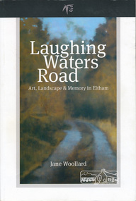
Book, Shire of Nillumbik, Laughing Waters Road: art, landscape & memory by Jane Woollard, 2016
... bricks ISBN 9780994486707 264 pages : illustrations, maps ..."Laughing Waters has been a source of inspiration for many artists and designers, and was a natural extension of the dynamic art and lifestyle movement that began in the 1930s at Montsalvat. It was also an important site in the development of the Melbourne art scene in the 1960s and '70s, especially the earth building movement known as the Eltham Style. Since 2001 more than eighty artists have been in residence at Laughing Waters in Birrarung House and Riverbend. Their experiences and art making are woven together with Wurundjeri, European and family histories to create an evocative account of a special place in a bushy outer suburb of Melbourne." -- back cover. Eltham District Historical Society is acknowledged in the Acknowledgments section of this book.264 pages : illustrations, maps, portraits ISBN 9780994486707laughing waters, eltham, yarra river, artists, killeavey, mud bricks -
 Eltham District Historical Society Inc
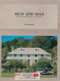
Book, Earthbuild, Mud and Man: a history of earth buildings in Australia by Ted Howard, 1992
Includes references to local sites Bear's Castle, Yan Yean (City of Whitlesea), mud brick houses in Eltham, including at Montsalvat and Eltham Community Centre, Smith's Gully, Plenty Baptist Church and Warrandyte. Includes chapter on Alistair Knox. The author's own home appears in the book on page 100. It was situated at Batman Road, Eltham next to the manse and church opposite Stanley Avenue. It was demolished for unit development June 2004 after the author's death in 2003. A significant and oft cited history of the mud brick earth construction style of architecture which includes a number of examples within the Shire of Nillumbik, known to be a site of the environmental earth building movement following WW2.198 p. : ill. (some col.), maps ISBN 0646069624earth construction, mud bricks, pise, domestic architecture -
 Eltham District Historical Society Inc
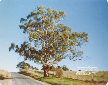
Photograph, Peter Bassett-Smith, White Gum, Main Road Eltham-Yarra Glen, Kangaroo Ground, June 1977, 1977
Colour photograph of a Eucalyptus Viminalis (White Gum or Ribbony Gum or Manna Gum) on Main Road, Eltham-Yarra Glen (Melways Directory Map 23 D1) looking west approximately 1 mile from Kangaroo Ground approx. opposite Andy Avard's gate.eltham yarra glen road, kangaroo ground -
 Doncaster RSL Sub Branch
Papers Bomber D4854
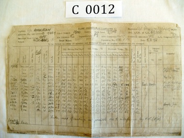
... Roads Doncaster East melbourne Maps 11-02-43 Wilhelmshaven,8-03 ...Maps 11-02-43 Wilhelmshaven,8-03-43 Nurnburg 27-03-43 Berlin, logs Nurnburg and Berlin. Lancaster Squadron 156 Pathfinder RAF Warboys Huntingdonshire.Sgt. Patrick Brougham(Faddy) Commenced operations Feb 1943 killed on operation to Skoda16-04-1943 aged 18 1/2, buried with his six companions Brimond near Rheims France.Maps three Missions and Engineers log for two missions -
 Warrnambool and District Historical Society Inc.
Map - An Angler's map of the Hopkins River Estuary, Angler's map Hopkins River, 1980s
... Street (south of Merri St) Warrnambool great-ocean-road ...This is a map of the Hopkins River Estuary prepared by Dr John Sherwood for the benefit of anglers. The information on the sheet includes the location of sand banks, the water depths, boat ramp facilities and public access facilities. Some of the information has been gathered from aerial photographs. The map has been produced by the Warrnambool Institute of Advanced Education which was developed in the late 1960s from the tertiary section of the Warrnambool Technical College and with all its departments established by 1984 at the Sherwood Campus five kilometres from Warrnambool on the Princes Highway. Today the site is occupied by Deakin University, Warrnambool campus. The Warrnambool Anglers’ Club has its headquarters on the banks of the Hopkins River near the mouth of the river and the Lyndoch Aged Care facility.This map is of interest as a specialist one, providing fishermen with detailed information on all aspects of the Hopkins river estuary. Fishing has been both a profession and a popular recreational pursuit for Warrnambool residents since the early days of the city’s settlement. The Hopkins River Estuary has been a focal point for fishermen throughout Warrnambool’s history. This is a sheet of paper folded three times to produce a folded map. The front cover has a black and white photograph of two fishermen with a large fish. The map of the Hopkins River Estuary is in yellow, blue and black and covers the side of one sheet and three quarters of the other side. There is an advertisement for the Hopkins River Boathouse with a black and white sketch of the boathouse and notes on the map written by Dr John Sherwood. There are several diagrams showing the water depths. The map has some silverfish damage and some tearing at the folds. warrnambool anglers’ club, history of warrnambool, hopkins river, hopkins river estuary, john sherwood -
 Warrnambool RSL Sub Branch
MAP TO ACCOMPANY HEAVY ARTILLERY SCHEME FOR MOBILE WARFARE".....marked with 'Lanes' and Corps/Division Boundaries, Ordnance Survey, 1:40,000, France. Sheet 62c, Dec 1917. (centring on Peronne and Mont St Quentin), December 1917
Shows detail of Artillery Planning in the area of Peronne & Mont St Quentin. Inscribed "Map to accompany H.A. Scheme for Mobile Warfare". Marked with 'Lanes' and Corps/Division Boundaries.The donor, Staff Sergeant R.O. (Bob) Snape, Reg No 8651, enlisted as a Stretcher Bearer in 1915 but, because of his secretarial skills was employed in HQ positions as soon as he arrived in France and as a stenographer who worked as Confidential Clerk to General Sir John Monash from June to December 1918; and subsequently, for General Sir Talbot Hobbs until June 1919. The map was very likely directly used in the planning of the 1918 battles such as Mont St Quentin.Original Item recovered from possibly Australian Corps HQ, probably between the Armistice, 11 November 1918, and June 1919, when Staff Sergeant R.O.(Bob) Snape was repatriated. Shows detail of Artillery Planning in the area of Peronne & Mont St Quentin. Inscribed "Map to accompany H.A. Scheme for Mobile Warfare". Marked with 'Lanes' and Corps/Division Boundaries.snape collection -
 Warrnambool RSL Sub Branch
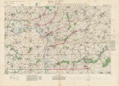
BOB: Map France 1:100,000 AMIENS, AMIENS, Geographical Section, General Staff, No 2364. October 1915; Ordnance Survey 1916; Minor Corrections 01/10/1916
Original Item souvenired from possibly Australian Corps HQ, probably between the Armistice, 11 November 1918, and June 1919, when the Staff Sergeant R.O.(Bob) Snape was repatriated.The donor, Staff Sergeant R.O. (Bob) Snape, Reg No 8651, enlisted as a Stretcher Bearer in 1915 but, because of his secretarial skills was employed in HQ positions as soon as he arrived in France and as a stenographer who worked as Confidential Clerk to General Sir John Monash from June to December 1918; and subsequently, for General Sir Tread moreTopographical map. Full colour snape collection -
 Warrnambool RSL Sub Branch
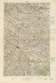
Map, 1:100,000 LENS Edition 2, 1915, Minor Corrections 27/10/1916
... Warrnambool great-ocean-road Snape Collection Topographical Map. Full ...Topographical Map. Full colour. Attached by glue to matching copy of 1:100,000 map sheet, 'Amiens' (as per 9002-Bob).snape collection -
 Warrnambool RSL Sub Branch
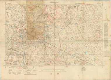
Map 1:10,000 GHELUVELT Edition 6 B (Local) GSGS 3062 Ordnance Survey July 1917 Trenches corrected to 12/9/1917
... Warrnambool great-ocean-road Snape Collection Map 1:10,000 GHELUVELT ...snape collection -
 Warrnambool RSL Sub Branch
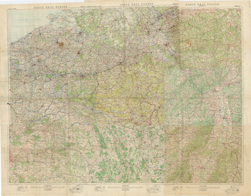
1:250,000 COMPOSITE WALL-MAP NORTHWEST EUROPE. Ordnance Survey Office, Southampton, 1914
Original Item recovered from possibly Australian Corps HQ, probably between the Armistice, 11 November 1918, and June 1919, when the Staff Sergeant R.O.(Bob) Snape was repatriated.Cloth-backed paper. 6 map sheets glued together to form one large wall map of NW Europe, covering from Normandy beaches to Cologne and Paris to Strasbourg.snape collection -
 Warrnambool RSL Sub Branch
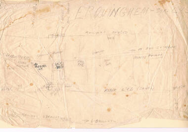
Bob Snape's HAND-DRAWN MAP of ERQUINGHAM-SUR -LYS, FRANCE, centring on 6th Field Ambulance base
snape collection -
 Warrnambool RSL Sub Branch
BOB: Map - 1:13,000, YPRES, Yperen, p.40, 'Baedeker's Belgium and Holland',1905,14th Edition (English), Leipzig: Karl Baedeker, Publisher, 1905
Bob Snape always included in his kit a few second hand Baedeker's guide books, as well as the 'Belgium and Holland' volume. Bob was a keen observer and commentator and used these guide books as any interested tourist. Bob's letters home often made reference to the history, culture and architecture of the countries he visited in the course of the war. Bob's English born father had lived and worked in France from 1878 to 1880 before his emigration to Australia.Two tone map in orange, grey and black. snape collection -
 Warrnambool RSL Sub Branch
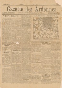
GAZETTE DES ARDENNES, 5 MAY 1918. 4th year, No 621, German newspaper, in French, for the occupied territories, printed in Charleroi, Belgium. (TRANSLATED IN PART by W.Barber), 5 May 1918
Original, single page propaganda broadsheet, collected by Bob Snape, when he was working as Confidential Clerk to General Sir John Monash, with Australia Corps HQ, in Belgium, late 1918. Yellowed with age, but despite some tears along the folds and a hole the size of a 20 cent piece, it is a good legible document with a front-line mapsnape collection -
Warrnambool RSL Sub Branch
TRENCH MAP, 1:20,000 FRANCE. Sheet 36 NW. Edition 6 B. GSGS 2742. Ordnance Survey 1916. Trenches corrected to 5/5/1916
... Warrnambool great-ocean-road Snape Collection TRENCH MAP, 1:20,000 ...snape collection -
 Warrnambool RSL Sub Branch
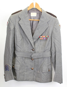
Service Jacket; Army Nurses Uniform, Early 1940's
This uniform was worn by Sister Winifred Ride during World War 2.. Nurses played a key role in the conflict through their care and compassion to the servicemen who were wounded and sick.The nurses uniform is symbolic of the sacrifice and service of the many women who served their country in WW2. Grey fitted, lined jacket with long sleeves, collar and lapels. Three front metal buttons buttons and two smaller buttons on each sleeve. Dark green epaulette with four metal buttons on each shoulder (Right side is faded). Two hip pockets with one button fastener. One internal pocket with small grey button. Unit patches on each sleeve and four inverted service chevrons on right sleeve at wrist. Two ribbon bars containing 5 Campaign Ribbons on left side of front, attached with standard 'brooch' fitting . Belt (same material as jacket) passes through two loops on back of jacket and is fastened by two buttons, hidden when belt is fastened. Metal buttons stamped with map of Australia with crown above and the words Australian Military Forces around. Makers label inside back below collar: " /tailors and habit makers, J .RAVENSDALE & SON Nicholas Bldg Swanston Street Melbourne". Name of owner handwritten "Sister Ride:" -
 Warrnambool RSL Sub Branch
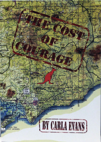
Book, THE COST OF COURAGE
Paperback. Title superimposed on coloured map of VietnamAuthor Carla Evans Published 2012 -
 Warrnambool RSL Sub Branch
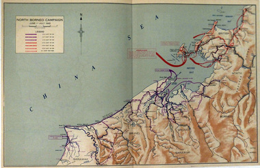
Map, NORTH BORNEO CAMPAIGN. June-July 1945
... Warrnambool great-ocean-road Map WW2. North Borneo Different coloured ...Paper. Colour. Different coloured arrows show troop movements in Brunei and Labuan Islandmap ww2. north borneo -
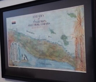
 Warrnambool RSL Sub Branch
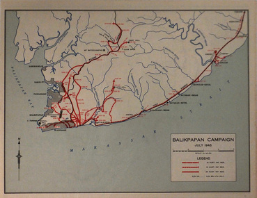
Map, BALIKPAPAN CAMPAIGN. July 1945
... Warrnambool great-ocean-road Map. Balikpapan Legend shows troop ...Paper. Basic colourLegend shows troop movements during the Campaignmap. balikpapan -
 Warrnambool RSL Sub Branch
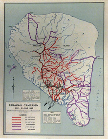
Map, TARAKAN CAMPAIGN. 1st May-21st June 1945
Paper, Basic colourLegend shows troop movements during the Campaign on Tarakan Island. -
 Warrnambool RSL Sub Branch
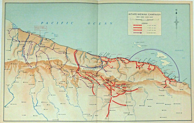
Map, AITAPE-WEWAK CAMPAIGN. Nov 1944-Aug 1945
Paper, basic coloursLegend shows troop movements during the Campaignww2 aitape-wewak -
 Warrnambool RSL Sub Branch
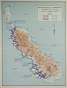
Map, BOUGAINVILLE CAMPAIGN. Nov 1944-June 1945
Paper, Basic coloursLegend shows troop movements during the Campaign -
 Warrnambool RSL Sub Branch
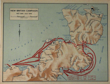
Map, NEW BRITAIN CAMPAIGN. October 1944-July 1945
Paper. Basic coloursLegend shows troop movements during the Campaign -
 Warrnambool RSL Sub Branch
Photograph - Aitape Wewak Campaign Map WW2, Aitape Wewak Campaign. 2/2 Battalion Jan-Aug 1945
Photographic copy of original which is in private handsStory of 2/2 Battalion in NG in 1945 and its history with present owners