Showing 3368 items
matching 5 photos
-
 Kiewa Valley Historical Society
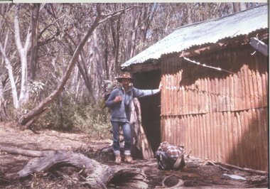
Photograph - Folder of Photographs – Photocopied set of 10 black and white photographs (pages 19 - 28) from the display folder put together by KVHS to document life on the Kiewa Valley Hydro-electric Scheme
Although the Kiewa Hydro-Electric Scheme was first proposed in 1911, construction did not commence until 1938. As part of the push to cut electricity costs and diversify supply, the Victorian Government (circa 1930) initiated the conversion from primarily brown coal supply to hydro – electricity. Field investigations during the 1940’s resulted in a new proposal for a scheme that had more than double the capacity of the 1938 scheme. The Kiewa Hydroelectric Scheme became the largest scheme of its kind in the State Of Victoria and the second largest scheme in Australia. The number of personnel involved in the planning and construction of the scheme increased dramatically. During the late 1940’s, most activity centred around the construction of the West Kiewa Power Station, Rocky Valley Reservoir, McKay Creek Power Station and the Bogong Creek Aqueduct.A common thread across all the larger hydro scheme constructions was the need for workers, both qualified and unqualified who came from around the world seeking a new life for themselves and their families. New accommodation and facilities were required for the army of workers engaged in construction in often remote and wild areas. The SEC had a high demand for timber, and set up the first of a number of sawmills at Bogong Creek in 1939 and set up the first hardwood logging in the headwaters of the Kiewa River. These new ‘towns’ such as Mt Beauty and Bogong, survived, serving the needs of operational personnel and their families, and expanding with growth of new industries. Mount Beauty, and to a lesser extent Bogong, are among these places. Large A3 size spiral bound display folder containing 21 pages of photocopied black and white photographs of various aspects of the early days of the Kiewa Valley Hydro-electric scheme including equipment, various work sites and photographs of workers and their families. 1-Allis Chalmers Tractor School 2- Gardens outside Administrative Office – Mt Beauty 3- Mt Beauty house – 1950 4-Bridge over Pretty Valley River, Bogong 5-Rocky Valley Spillway Tunnel break through 6-Ni 1 Headrace Tunnel drilling face 7-No 4 Power Station Drilling 8-Clover Dam Flood Waters 9-No1 Head Race Tunnel Portal Building 10-Clover Dam 1-STATE ELECTRICITY COMMISSION OF VICTORIA Date: 5.9.49 Time: 10amm No K5174 Kiewa Hydro Electric Works Allis Chalmers Tractor School Page number 19 2-STATE ELECTRICITY COMMISSION OF VICTORIA Date: 22.2.50 Time: 3.30pm No K5601 Kiewa Hydro Electric Works Gardens outside Administrative Office – Mt Beauty Page number 20 3-Mt Beauty house – 1950 Page number 21 4-STATE ELECTRICITY COMMISSION OF VICTORIA Date: 23.10.50 Time: 11.15am No K6331 Kiewa Hydro Electric Works Bogong-Bridge over Pretty Valley River Page number 22 5-STATE ELECTRICITY COMMISSION OF VICTORIA Date: 23.6.50 Time: 2.30pm No K5844 Kiewa Hydro Electric Works ROCKY VALLEY SPILLWAY TUNNEL BREAK THROUGH Page number 23 6-20/3/52 – No. 1 Headrace Tunnel Drilling face (E.E.E. contract) Page number 24 7-6/6/52 – No 4 Power Station – Drilling Page number 25 8-STATE ELECTRICITY COMMISSION OF VICTORIA Date: 6/6/52 Time: No K7113 Kiewa Hydro Electric Works Clover Dam Flood Waters Page number 26 9-STATE ELECTRICITY COMMISSION OF VICTORIA Date: Oct 1952 Time: No K7239 Kiewa Hydro Electric Works No. 1 HEAD RACE TUNNEL PORTAL BUILDING. Handwritten underneath – This information from Ron White-the later Principal Hydro Engineer of the SEC. Oct 1952 Location incorrect? All work on No 1 had ceased after financial crash of 1951. This photo would refer to No 4 Headrace Tunnel? Page number 27 10-STATE ELECTRICITY COMMISSION OF VICTORIA Date: Jan 1953 Time: No K7307 Kiewa Hydro Electric Works CLOVER DAM Page number 28 secv; kiewa hydro electric scheme; bogong; mt beauty; construction area -
 Kiewa Valley Historical Society
Photograph - Folder of Photographs – Photocopied set of black and white photographs (pages 49 -58) from the display folder put together by KVHS to document life on the Kiewa Valley Hydro-electric Scheme
Although the Kiewa Hydro-Electric Scheme was first proposed in 1911, construction did not commence until 1938. As part of the push to cut electricity costs and diversify supply, the Victorian Government (circa 1930) initiated the conversion from primarily brown coal supply to hydro – electricity. Field investigations during the 1940’s resulted in a new proposal for a scheme that had more than double the capacity of the 1938 scheme. The Kiewa Hydroelectric Scheme became the largest scheme of its kind in the State Of Victoria and the second largest scheme in Australia. The number of personnel involved in the planning and construction of the scheme increased dramatically. During the late 1940’s, most activity centred around the construction of the West Kiewa Power Station, Rocky Valley Reservoir, McKay Creek Power Station and the Bogong Creek Aqueduct.A common thread across all the larger hydro scheme constructions was the need for workers, both qualified and unqualified who came from around the world seeking a new life for themselves and their families. New accommodation and facilities were required for the army of workers engaged in construction in often remote and wild areas. The SEC had a high demand for timber, and set up the first of a number of sawmills at Bogong Creek in 1939 and set up the first hardwood logging in the headwaters of the Kiewa River. These new ‘towns’ such as Mt Beauty and Bogong, survived, serving the needs of operational personnel and their families, and expanding with growth of new industries. Mount Beauty, and to a lesser extent Bogong, are among these places. Large A3 size spiral bound display folder containing photocopied black and white photographs of various aspects of the early days of the Kiewa Valley Hydro-electric scheme including equipment, various work sites and photographs of workers and their families. 1-Workmen working inside one of the tunnels. 2-Workman drilling in West Kiewa Tunnel 3-Junction Dam wall construction 4&5-2B&W photographs Kiewa House residents ready to go to a ball in Mt Beauty 6-Workmen warming up in front of a fire at No 1 bench 7-Workmen being hauled in at No 4 P.S Shaft 8-No 4 Power Station – Drilling 9-Workmen eating a hot meal in the tunnel. 10-2 photographs (a)Pretty Valley camp showing workman’s huts and construction materials & (b)Worker in Langford Gap Basalt Hill Tunnel face 11-Tunnel entrance (unlabelled) with rail tracks in foreground 12- Workmen drilling at No 1 Head race tunnel-Drilling face 13- No 1 Power Station 14-Workmen at the entrance to one of the SECV tunnels under construction 1-SECV number at bottom of picture Half obscured possibly K8461 Page number 53 2-In West Kiewa Tunnel Page number 54 3- Construction of Junction Dam wall – approximately 1941 Page number 55 4&5- Residents of Kiewa House at Bogong ready to go to the ball at Mt Beauty-1946. Handwritten on a copy of the photo on opposite page Mrs Lorna Crosset filled out the names *Dad was Des Crossett – his daughter is Gael Petcopoulis Greta engaged to John broke it off. Charlie, Rosalind, Bill, Priscilla, Max Lawrence-Dad’s Boss, Mary & Max married, Mary, Kay, Gwen McPherson Mum’s boss, John McCluskey (c) At No. 5 Bench Page number 56 6- STATE ELECTRICITY COMMISSION OF VICTORIA Date: 27.2.51 Time:2.15pm No K6373 Kiewa Hydro Electric Works No. 4 P.S. Shaft – Haulage of men in buckets (b) As above Handwritten at top of photo Appendix 4 page number 57 7- STATE ELECTRICITY COMMISSION OF VICTORIA Date: 6.6.52 Time:… No K7122 Kiewa Hydro Electric Works No. 4 POWER STATION – DRILLING page number 58 8-No markings page number 59 9-(a)Handwritten under photograph Approx. 1948/49 (b) STATE ELECTRICITY COMMISSION OF VICTORIA Date: 28.10.54 Time:.. No K7860 Kiewa Hydro Electric Works LANGFORD GAP BASALT HILL TUNNEL FACE Page number 49 10-(a) No markings 11- STATE ELECTRICITY COMMISSION OF VICTORIA Date: 20.3.52 Time: No K6979 Kiewa Hydro Electric Works No. 1 HEAD RACE TUNNEL – DRILLING FACE (E.E.E. CONTRACT) ‘The Frenchies’ (E.E.E) as they were affectionately known Page number 50 12-31.5.56 No. 1 Power Station Aggregate Stock Piles. Page number 51 13&14-No markings Page number 52 secv; kiewa hydro electric scheme; bogong; mt beauty; construction area -
 Kiewa Valley Historical Society
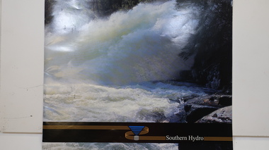
Booklet - Southern Hydro, Southern Hydro
Southern Hydro Ltd. was established in the late 1990s as a result of the disaggregation of the former State Electricity Commission of Victoria. It operates 10 power stations mainly in the north-east of VictoriaSouthern Hydro continued to encourage tourism as did the former State Electricity Commission of Victoria. This brochure is very similar to one previously published by the SECV "Victoria's Hydro Power" except only including those that it operates. Within the KHES the power stations were McKay Creek, Clover and West Kiewa. The change of ownership of hydro power from a government body to private enterprise in the late 1990s is of significant interest to the historian and consumer.Colored photo water spraying onto rocks with black strip across the bottom and logo (4 gold lines forming an "S", a blue triangle with grey cylinder beneath) of Southern Hydro within the strip. Back cover has a similar photo with 4 small photos of men inserted in the black column. This 23 page book gives a history of Southern Hydro and its 10 hydro-electric power stations that it operates. The book lists these and gives a description of each.Top right hand corner of page 5 has a piece of tape stuck over the print with "Page 11 to photo copy & enlarge" secv; khes; mckay creek power station; clover power station; west kiewa power station; mount beauty; rocky valley dam; -
 Kiewa Valley Historical Society
Photograph - 30 black and white photographs (assorted sizes) plus page from a newspaper and copied article on A4 paper, c1880's c1910 - 1920 (photographs) Newspaper 1961
K2,3 and4 are of the Kiewa River and two of the bridges spanning the river along the valley. K3 and K4 would have been taken in the 1880's and show the type of trees and plant growth along the river prior to land clearing for farming. K5 is of the Running Creek Cricket Team and therefore there was sufficient population in the area to form and maintain a team as well as have other teams in the relatively near vicinity to provide competition. Note the horse drawn cart which provided transport. Date taken is unknown but possibly c 1910. The Mt. Buffalo Chalet was built in 1910 by the Victorian Government. It was Australia's first ski resort and has served generations of skiiers, hikers and families over the years. It was built for 3195 pounds and has had stories and wings added since and is the largest timber building in Australia. B4 is the earliest photo in this group as the garden is in early stages of development - the other photos show the growth of the shrubs and would be taken about c 1920. Note the cars and motor bikes. It closed in 2006. The other photos are of general interest only but interesting to see that there were donkey's grazing. There is no information as to their purpose on Mt. Buffalo. Four different Kiewa Valley families are represented in the photographs. Their descendants still live in the Valley and carry on the traditions of beef and dairy farming. Of particular interest is the photo of Miss Marjorie Clemence, the first School Teacher of Upper Gundowring School. Gundowring pastoral run was taken up in 1838 and occupied by framers in the 1860's. The area was known as Gundowring and Upper Gundowring. The Gundowring School was opened in 1871 and most likely the Upper Gundowring school would be built at the same time. It was School No. 2733 and situated in Boyd Road. It closed in 1953 when the Kiewa Consolidated School opened. The newspaper page describes the activities in which the local community of Kergunyah were in engaged in that period - Red Cross, Fire Brigade, cattle round up and some of the identities involved. The article photocopied from the Yackandandah times states that he (Norman Coad) "was sent to the Ovens District Hospital, Beechworth for treatment" which would mean that this was the closest hospital to the Kiewa Valley for emergencies in 1912.The Kiewa Valley photographs are of social significance showing two of the early bridges allowing the community easy access to both sides of the river and also the tree and plant growth before land clearing for farming. The photos of Mt. Buffalo Chalet have social, architectural and historical significance. the Chalet has been used by skiers, bush walkers and day trippers since its completion in 1910 and its closure in 2006. It is listed in the Victorian Heritage Register. The family photographs are of social and historical significance as they are of early farming families in the Kiewa Valley and also depict the dress, of both men and women) in the late 1880's. The write up in the Weekly Times has social significance as it depicts the social and farming activities and photos of the local residents from around that area. The article from the Yackandandah Times is of a personal nature with concern for the individual involved. Note: There is a photo of the gentleman mentioned in the article (Mr. Norman Coad) in the Families of the Kiewa Valley (F4) as above.30 black and white photographs - 5 of the Kiewa Valley, 8 of families of the Kiewa Vallley and 17 of Mt. Buffalo. Various sized photos. Page from the Weekly times and copied article from the Yackandandah Times on A4 sheet.(Note for easier identification they have been numbered and grouped - K1-5 (Kiewa Valley), F1-8 (Families) and B1-17 (Mt. Buffalo). K1: handwritten in ink, lower L hand corner "Bogong in the distance". K2: handwritten in ink lower L hand corner "Mongan's Bridge or Towonga". K3 handwritten in ink "Taken from Mongan Bridge looking up stream". K4 - no inscription. K5: handwritten in ink, back of photo "Running Creek Cricket Team". F1: handwritten in ink on back "Mrs. Heap" and lower down in pencil "1880's". F2 handwritten in pencil at top of back phot "Land at Tawonga TROVE The Y'dah Times 20/2/1913" and lower down in ink "Henry Ellis Larkin". F3: handwritten in ink bottom edge "Mrs Coad". Note that this photo is a postcard. F4: Written in ink lower edge "Norman Coad". Note this photo is also a postcard. F5: Lower left corner in Ink "Harry Larkin". F6: lower half back of photo, in ink "Bernie Maddison". F7: on back of photograph in ink "Miss Marjorie Clemence first School Teacher Upper Gundowring: and underneath, in pencil "C1880's". F8: Handwritten in ink on back of photo "Frank & Mrs. Keat & Lesley of Tawonga". Lower down in pencil "c1912-1914". B1: Back of photo in ink "The Chalet Mt. Buffalo". B2: no inscription. B3: "chalet at Bufflo" in ink lower left corner. B4: This is a post card. Written in ink is "Mt. Buffalo Chalet". B5 - B10 printed in ink, lower left corner "Buffalo". B11: no inscription. B12: "Mt. Buffalo" lower R corner. B13: "Buffalo?". B15: Printed in ink lower edge "Picnic at Buffalo". B16: "Donkeys on Mt. Buffalo" printed in ink lower edge. B17: handwritten in ink across back of photo "Donkeys & top of Mt. Buffalo with the Monileith in the distance". A4 sheet of paper describing an accident to Mr. Norman Coad. Under article is : Yackandandah Times (Vic: 1890 - 1931), Thursday 18 July 1912, page 3. A page torn from the Weekly Times, June 14, 1961 and entitled "Kergunyah has picturesque setting". kiewa valley, farming, families, kergunyah, gundowring upper, mt. buffalo chalet, briggs family, larki family, coad family, clemence family, laskowski collection -
 Kiewa Valley Historical Society
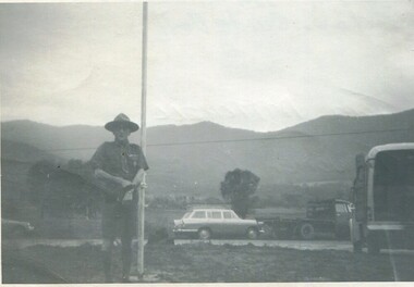
Photograph - Coloured Photographs x 5 - Bogong High Plains, January 1969 and c1970
Bivouac Hut was built in 1935 on the Northern end of Mt. Bogong, on the Staircase Spur, about halfway to the summit. It was funded by Cleve Cole and he arranged for Walter Maddison to build it. Cleve Cole dedicated his life to the mountains and wanted to make them safer to visit - more huts and improved maps, pole lines and tracks. He perished in the winter of 1936 after attempting to make the first winter crossing from Mt. Hotham to Mt. Bogong on skis. The two others with him, Howard Michell and Mick Hull survived. The weather conditions were extreme at the time and having made the summit of Mt. Bogong they then became disorientated in the blizzard and came down the southern end of Bogong instead of the northern end . Howard Michell made it out to Glen Valley, a small mining town, to get help. Mick and Cleve were carried out on rough bush stretchers and Cleve died a few hours later. The Summit Hut was funded by Howard Michell and built in the 1940's. It was deliberately burnt down in the early 1980's. Bivouac hut was rebuilt in the 1980's.These photographs are of historical significance. Both huts were funded by experienced bushwalkers to provide shelter from the weather and so make walking and skiing in the area safer. They are both now gone with Bivouac being replaced with a more modern structure but there is nothing left of the Summit Hut. 5 coloured photographs, A4 in size, 4 near the summit of Mt. Bogong (Three of the Summit Hut) and one of Bivouac Hut on the Staircase Spur leading up to the summit.1. Hand written in ink on back of Photo - "Mt. Bogong Sep. 1976' - all underlined. Below this "Staircase Spur Hut The bloke in the hat me (David Jones)". 2. Handwritten in ink on back of photo - "Mt. Bogong winter 1970" (underlined). Underneathe "Same old Hut". 3. Handwritten in ink "Mt. Bogong Jan. 1969" (Underlined) Underneath "Tawonga Saddle looking towards the Summit". 4.Handwritten in ink back of photo "Mt. Bogong Jan. 1969" (underlined) Old hut near Summit, since removed, at the top of Staircase Spur. View looking out over Kiewa Valley." 5.Hand written on back of photo "Mt. Bogong Jan. 1969" (Underlined). Underneath - " Same old Hut (Staircase Spur) early morning".mt. bogong, summit hut, bivouac hut -
 Kiewa Valley Historical Society
Collection - Mt Beauty Drama Group
Mt Beauty Drama groupMt Beauty formed a drama group to entertain the community as they lived in a small remote town. Collection consists of: 1. Six typed A4 sheets - 'Out in the Cold Cold Snow' 2. Blue booklet A5 94 pages 'Sailor, Beware' and 3 copies of the handout to the audience including the cast 3. Orange booklet A5 8 pages 'Red Hot Cinders' and a copy without the orange cover. 4. Foolscap size with yellow pages at the front followed by 42 white pages 'Babes in the Wood' 5. A white card listing the cast for 'The Importance of Being Earnest' 6. Colored pages of handout for 'Cinderella' including the cast and dated 1959 7. 3 newspaper cuttings 8. 4 photos - Sailor Beware Photos are labelledmt beauty, drama group, entertainment, organisation, the arts -
 Kiewa Valley Historical Society
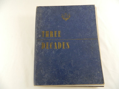
Book - Historical - SECV x3, Three Decades. The Story of the State Electricity Commission of Victoria from its Inception to December 1948, First Published March 1949
At the time of writing this book The State Electricity Commission of Victoria had been in existence for 30 years. This book tells something of its progress and achievements during that period. It includes brown coal and water power. The Commission was to develop and use these natural resources through the expertise and experience of the Commissioners, its staff and employees. Historical: Chapter 5 "The War Years - and Kiewa." describes the early stages of the Kiewa Hydro Electric Scheme. Photos, map and diagrams of the Kiewa Scheme are also included. Hard cover blue bound book with the SECV insignia and the title "Three Decades" both in gold on the front cover. Book includes coloured and black and white photos.Handwritten inside front cover: "Bob Burnett". Title page: hand written in print and crossed out: "L.D.Miller / Tawonga". Not crossed out - "(Cheryl)"state electricity commission of victoria. kiewa hydro electric scheme. bogong high plains. pretty valley. kiewa valley. -
 Kiewa Valley Historical Society
Photos - x5 Girl Guide Camp - Tawonga, January 1964
... Guide hall" 2 - 5 "Guides" 1. Tom Mitchell at Tawonga Guide Hall ...Tawonga guides was a popular club for girls during the 1960's.Tawonga Girl Guides existed in 19641. Tom Mitchell at Tawonga Guide Hall 2. Five young girl guides in hats at camp 3. Group of young campers tying poles 4. Line of tents at camp 5. Interior of tent1. "Tom Mitchell at Tawonga Guide hall" 2 - 5 "Guides"tom mitchell. girl guides. barree camp. badges.tawonga. camping. -
 Kiewa Valley Historical Society
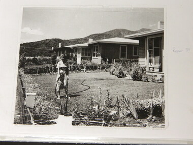
Folder - Early Photos of Mt Beauty
Mt Beauty township was built during the 1950's to house the employees of the State Electricity Commission working on the Kiewa Hydro Electric Scheme. After the completion of the Kiewa Hydro Electric Scheme many houses were sold and the public buildings handed over to the Alpine Shire. Mt Beauty has always been a tourist destination especially with its proximity to the ski fields at Falls Creek.This folder contains many early photos of Mt Beauty showing the construction town during its development during the Kiewa Hydro Electric Scheme and its early days of tourism. A3 size black plastic folder with clear plastic sleeves holding early black & white photos of Mt Beauty township. Also included are: 1. 3 foolscap pages -Nov., 1953 Kiewa Hydro-Electric Scheme Progress. 2. SECV Drawing Plan (No. K6242) of Mt Beauty House - 3 angles and floor plan, English Pre-cut Type 3B.ILA with note that all houses with prefix 3B are similar. 3. Orange, black and white pamphlet "Welcome to Kiewa" 4. Tourist postcard 'fold-up' of 11 postcards "Mt Beauty and the Kiewa Scheme, Victoria 5. Drawing Plan of 'Mt Beauty Housing. Use of Prefabricated Cubicles for Houses. Type C.1 6. Drawing Plan of 'Kiewa Scheme Mt Beauty Housing Type "G". 7. 5 pages on "Twelve Tips on Caring for Old Buildings 8. Booklet advertising Mt Beauty housing for sale including activities available in the area. (1960's) 9. List of Photos from SECV held by KVHS Some photos have handwritten labels mt beauty. secv. kiewa hydro electric scheme.tourism. housing. construction town. falls creek. -
 Kiewa Valley Historical Society
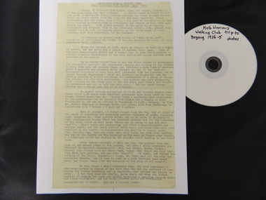
Diary Extract - Trip to Bogong High Plains Xmas 1934 & DVD photos, original diary 1934
The Melbourne Women's Walking Club enjoyed bush walking as a hobby travelling to the north east of Victoria, using pack horses and camping on a 9 day hike. One of the woman, 'Bill' describes each day in detail - what they did, where they went and what they saw giving an insight into walking and the Bogong High Plains in the mid 1930's before the Kiewa Hydro Electric Scheme opened up the area. The diary mentions a photo being taken by Mr Blackwell on the 9th day, New Year's Eve 'from a lovely bush track from which, looking back at intervals we got our final glimpse of Fainter. 5 miles from from our destination'.Historic: This extract from the diary of 'Bill', a member of the Melbourne Women's Walking Club gives an insight into walking in the mid 1930's and describes the Bogong High Plains as it was then before it was opened up with a road built during the Kiewa Hydro Electric Scheme. It describes the area in summer including the flora & fauna, cattle grazing & cattlemen, the huts, the gauges set up by the State Electricity Commission of Victoria, the people working up there, the weather and the lifestyle of the walking group - their food, duties, swimming etc.. Six double sided typed photocopied yellow pages describing the Melbourne Women's Walking Club trip to the Bogong High Plains at Christmas in 1934. Also one page photocopied of the programme for Year 1934-35 with an arrow pointing to the above trip and a page with a photocopied sepia photo of the "Melbourne Women's Walking Club / Bogong High Plains / Dec. 1934. DVD 12 photos of the trip arrow showing trip from Programme. Title of photo "Melbourne Women's Walking Club / Bogong High Plains / Dec. 1934melbourne women's walking club. bogong high plains. camping. pack horses. cattlemen's huts. -
 Warrnambool and District Historical Society Inc.
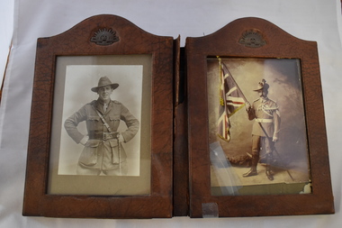
Artefact, Fold out leather frame with 2 sepia photographs of soldiers, Early 20th Century
This frame contains two as yet unidentified soldiers from two of Australia’s earliest overseas conflicts. The WW1 soldier has the rank of Captain and the Boer War soldier has the three stripes of Sergeant. It is possible that he belongs to the Coronation Contingent of Edward V11 in 1902.These soldiers were selected form all over Australia with 42 coming from Victoria. The Australian War Memorial cites a number of approximately 16000 soldiers who fought in the Boer War from 1899-1902. Of that number 282 died in action or as a result of wounds while around 320 died as a result of disease and accidents. Six received the Victoria Cross as well as other awards for bravery. The First World War had more drastic consequences for Australia. From a population of less than 5 million, 416809 men enlisted of whom over 60,000 were killed with 156000 wounded gassed or taken prisoner. Australian fought from 1914-1918 from Egypt, Turkey, and the Western Front in Europe. These photographs are representative of many photos which are kept in remembrance of Australian soldiers who fought in wars particularly the two world wars. The Boer war photo is a rarer one.This bi- fold photo frame is rectangular in shape with a rounded section at each top. It is leather in composition and has the Rising Sun insignia in each arch which appears to be metal. There are glass covering two photographs one of a Boer War soldier and the other of WW1. It is hinged in the middle with a double layer of leather which is broken .The Boer war photograph has a coloured flag and medal ribbons. The two Rising Sun badges have Australian Commonwealth Military Forces. The frame itself has J C Vickery Regent St W stamped on the back in gold with a crown above it. The photograph of the WW1 soldier has Hana Studio Ltd 22**** which although unreadable has been matched with another photograph to read,” 22 Bedford St Strand London. The photograph of the Boer War soldier has no studio identity. warrnambool history, unknown soldiers of warrnambool, boer war soldier, world war 1 soldier -
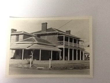 Port of Echuca
Black and white photograph, 20.04.1979
Relates to a series of 5 photos:P000094-P000098 of the front of the Bridge Hotel on the corner of Murray esplanade and Hopwood gardens. These photos taken in 1976, were before the Port Restoration Scheme renovated the hotel.The Bridge Hotel, Echuca is of historical and social significance in that it was originally built by Henry Hopwood, the founder of Echuca. Hopwood built the hotel to provide accommodation to people using his punts across the Campaspe and Murray rivers. The hotel was situated between the 2 punts. The hotel provided for a variety of levels of accommodation from grand rooms to very basic rooms. At the time of the photos the hotel was 120 years old and became an important part of the Port of Echuca tourism. Black and white photograph of the Bridge Hotel , taken from the corner of Murray esplanade and Hopwood gardens. A power pole pokes through the verandah roof of the eastern (left) wing. The eastern wing of the Bridge is clearly visible.On sign on the front verandah "unauthorised entry not permitted". On back of photo in pen :" 1"bridge hotel, echcua, port restoration scheme, bridge hotel restoration, echuca -
 Port of Echuca
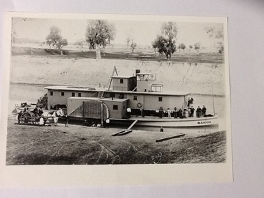
Black and white photograph, Earliest 1897
P. S. Marion Dimensions: 107 ft 11 in X 5 ft 3 in Tonnage: 157 tons Built: 1897, at Milang, S. A. References: Book: "Murray River Paddlesteamers" by D. Wardle. pp.22 Riverboats and Rivermen by W. Drake & M. PagePaddlesteamers were a common form of transport along the Murray river in the early 20th century. This photo shows a number of travellers on the boat, judging by their attire, workmen, cook, men in suits and ties as well as a group of people sitting on the bank, possible a woman and children with dog waiting for the boat to depart. There is also a horse drawn wagon with a number of people on and around it that could be waiting to pick up goods (or have unloaded) from the boat. At the back of the boat stacks of wheat bags (?) are visible.Black and white photograph of P. S. Marion moored by a river bank. There is a group of men standing towards the bow and a horse drawn carriage on the bank near the stern. Copy of an original photograph.On the front: MARION on the bow of the boat and on the wheelhouse. On reverse, in pen: Marion. where? Stamped in black: National Library of Australia.riverboats,, paddle steamers, p. s. marion -
 Port of Echuca
Photograph - Black and white photograph, Late 1970s
Relates to a series of 5 photos:P000094-P000098 of the front of the Bridge Hotel on the corner of Murray esplanade and Hopwood gardens. These photos, taken about 1976, were before the Port Restoration Scheme renovated the hotel. The Bridge Hotel was built by Henry Hopwood in 1858. This and the Bond Store were Echuca's first 2 brick buildings. Named from Hopwood's nearby pontoon bridge. The building was bought be The Council in 1970. Restored and reopened in 1975.The Bridge Hotel is an important part of Echuca's settlement and development. It was originally built by Henry Hopwood, the European founder of Echuca, in 1859. Hopwood built the hotel to provide accommodation to people using his punts across the Campaspe and Murray rivers that area central to the landscape of the Port. The hotel was situated on the land between both rivers and punts and provided for a variety of levels of accommodation from grand rooms to very basic rooms. At the time of the photos the hotel was 120 years old and became an important part of the Port of Echuca tourism. Black and white photograph of the Bridge Hotel , showing western wing before restoration.Stamped on the reverse "Gazemore Studio, D. G. Gay, 18 Frances Street Echuca 3625.bridge hotel, echcua, port restoration scheme, bridge hotel restoration, echuca -
 Eltham District Historical Society Inc
Photograph - Aerial Photograph, Landata, Eltham, Vic, Feb. 1956
Centred on present day Parsons Avenue at Leane Drive near the Maroondah Aqueduct, Eltham bounded by Lorimer Road to north, Thompson Crescent and Norman Road to south, Bells Hill Road to east and Parsons Road to west Historic Aerial Imagery Source: Landata.vic.gov.au Aerial Photo Details: Project No :250 Project : MELBOURNE OUTER SUBURBS PROJECT Run : 19 Frame : 5 Date : 02/1956 Film Type : B/W Camera : EAG9 Flying Height : 10000 Scale : 12000 Film Number : 1176 GDA2020 : 37°42'04"S, 145°11'09"E MGA2020 : 340064, 5825786 (55) Melways : 22 H1 (ed. 42)aerial photo, 1956-02, neil webster collection, allendale road, bells hill road, eltham, leane drive, lorimer road, maroondah aqueduct, melway 22h1, norman road, parsons road, research (vic.), thompson crescent -
 Eltham District Historical Society Inc
Photograph - Aerial Photograph, Landata, Eltham, Vic, Apr. 1963
Centred on present day Zig Zag Road and Main Road, Eltham bounded by Maroondah Aqueduct to north, Thompson Crescent and Arthur Street to south, Parsons Road to east and Glen Park Road and Banks Road to west. Historic Aerial Imagery Source: Landata.vic.gov.au Aerial Photo Details: Project No :486 Project : MELBOURNE (1963) PROJECT Run : 5 Frame : 59 Date : 04/1963 Film Type : B/W Camera : RC8 Flying Height : 5100 Scale : 9600 Film Number : 1805 GDA2020 : 37°42'24"S, 145°08'52"E MGA2020 : 336716, 5825114 (55) Melways : 21 J3 (ed. 42)aerial photo, neil webster collection, eltham, 1963-04, arthur street, banks road, glen park road, maroondah aqueduct, melway 21j3, parsons road -
 Eltham District Historical Society Inc
Photograph - Aerial Photograph, Landata, Eltham, Vic, Apr. 1963
Centred on present day Floriston Grove, Eltham bounded by Maroondah Aqueduct to north, Thompson Crescent and Diosma Road to south, Research Shops to east and Glen Park Road and Park West Road to west. Historic Aerial Imagery Source: Landata.vic.gov.au Aerial Photo Details: Project No :486 Project : MELBOURNE (1963) PROJECT Run : 5 Frame : 60 Date : 04/1963 Film Type : B/W Camera : RC8 Flying Height : 5100 Scale : 9600 Film Number : 1805 GDA2020 : 37°42'24"S, 145°09'29"E MGA2020 : 337622, 5825128 (55) Melways : 22 B3 (ed. 42)aerial photo, neil webster collection, eltham, 1963-04, diosma road, floriston grove, maroondah aqueduct, melway 22b3, park west road, research (vic.), research shops -
 Eltham District Historical Society Inc
Photograph - Aerial Photograph, Landata, Research, Vic, Apr. 1963
Centred on present day Thompson Crescent and Nicholson Close, Research bounded by Maroondah Aqueduct to north, Nyora Road to south, Eltham College to east and Eltham Gateway Hotel to west. Historic Aerial Imagery Source: Landata.vic.gov.au Aerial Photo Details: Project No :486 Project : MELBOURNE (1963) PROJECT Run : 5 Frame : 61 Date : 04/1963 Film Type : B/W Camera : RC8 Flying Height : 5100 Scale : 9600 Film Number : 1805 GDA2020 : 37°42'24"S, 145°10'06"E MGA2020 : 338528, 5825143 (55) Melways : 22 D3 (ed. 42)aerial photo, neil webster collection, eltham, 1963-04, eltham college, eltham gateway hotel and conference centre, maroondah aqueduct, melway 22d3, nicholson close, nyora road, research (vic.), thompson crescent -
 Eltham District Historical Society Inc
Photograph - Aerial Photograph, Landata, Research, Vic, Apr. 1963
Centred on present day Marconi Court, Research bounded by Maroondah Aqueduct to north, Thompson Crescent to south, Joselyn Drive to east and Eltham Research Oval to west. Historic Aerial Imagery Source: Landata.vic.gov.au Aerial Photo Details: Project No :486 Project : MELBOURNE (1963) PROJECT Run : 5 Frame : 62 Date : 04/1963 Film Type : B/W Camera : RC8 Flying Height : 5100 Scale : 9600 Film Number : 1805 GDA2020 : 37°42'24"S, 145°10'43"E MGA2020 : 339434, 5825157 (55) Melways : 22 F3 (ed. 42)aerial photo, neil webster collection, 1963-04, joselyn drive, marconi court, melway 22f3, research (vic.), research oval, thompson crescent -
 Eltham District Historical Society Inc
Folder, Jorgensen, Sigmund
1. Newspaper article (photocopy): Montsalvat's fighter for artistic integrity, Diamond Valley News (n.d.); Story Linley Hartley, Photo: Ron Grant 2. Magazine article: The Steward: Meet the steward of Montsalvat, caretaker of his father's dream and the bohemian beacon that continues to shine for the arts, Yarra Valley & Ranges Country Life (n.d.), pp46-50 (Nadine Cresswell-Myatt, Photos Zack Davis) 3. Newspaper article: Born to serve artists; former director of Montsalvat awarded medal; Patrick Phillips (Photo Robert McKechnie), Diamond Valley Leader, January 30, 2013 - awarded the Order of Australia Medal (OAM) 4. Newspaper article: Jorgensen bows out of Eltham landmark, Diamond Valley Leader, Wednesday, November 11, 2015 - former CEO of Montsalvat dropped as a director of the business 5. Newspaper article: Montsalvat, publication unknown (2006) - about Montsalvat being forced to sell off land in Christmas Hills, where Sebastain Jorgensen lived, to pay tax debt. 6. Funeral Service Booklet: Sigmund Jorgensen, 29.04.1940 - 21.07.2109Folder of information on SigmundJorgenseneltham cemetery trust, helen skipper, justus jorgensen, matcham skipper, montsalvat, sebastian jorgensen, sigmund jorgensen, order of australia medal (oam), morag fraser, bronwyn lewis, christmas hills festival, green wedge, montsalvat trust, funeral service -
 Eltham District Historical Society Inc
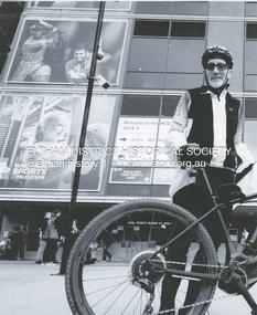
Folder, Connor, Jim
Eltham resident for more than 42 years, consultant in access and aged care issues, former Eltham Shire Councillor (1994), former member of Nillumbik Planning Special Committee (1996), community advocate, bike rider and President of Eltham District Historical Society from 2010 to present (2023) 1. How to Vote pamphlet: Lets make Eltham an even better place, Jim Connor for Eltham Council Central Riding - stood as an independent candidate against Nick McGowan 2. Newspaper article: Eltham's plans draw support; publication unknown (1994) - continuation of article about proposed realignment of Council boundaries and includes photo showing Cr Connor 3. Business Card: Jim Connor and associates, Consultant in Access and Aged Care Issues 4. Report: Meeting the challenge - we're well on the way! Nillumbik Budget 2005-2006 report card (8 page A4 report) featuring a photo of Nillumbik councillors and community members reviewing aerial photo of Eltham (includes Mayor Cr Greg Johnson, Cr Michael Young, Jim Connor, Russell Yeoman and two others) 5. Newspaper clipping, Local Knowledge, Diamond Valley Leader, November 2, 2011, p2 - interview with Jim Connor about living in the Diamond Valley 6. Consideration of an Honorary Life Membership for Jim Connor, Eltham District Historical Society 7. A Celebration of Community Historians at the RHSV's AGM, RHSV News, June 2019, p4 - presentation of RHSV Merit Award by RHSV President Richard Broome to Jim Connor 8. Newspaper article: Tree change a positive move, Why I love My Suburb, Diamond Valley Leader, July 24, 2019, p4 - interview with Jim Connor 9. Photo: B&W A4 print of Jim Connor with his e-bikeFolder of information on Jim Connoreltham district historical society, eltham shire council, jim connor, nillumbik shire council, royal historical society of victoria, council elections -
 Eltham District Historical Society Inc
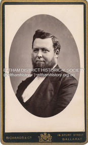
Photograph, Phillip Shillinglaw, c.1885
Photographer: Richards & Co. Portrait Parlours operated from 19 Sturt Street, Ballarat from 1881-1921 but with "Under Royal Patronage" appears to be 1881-1885. Phillip Shillinglaw was born Melbourne, August 7, 1842. He married Sarah Ann Kidd in Heidelberg, Victoria, February 28, 1872. In 1881 Phillip and Sarah and their small family moved to Eltham and made home in what was later to become known as Shillinglaw Cottage but which Phillip named 'Wattle Brae'. Shillinglaw Cottage is significant to Eltham’s local history. It is one of the earliest known buildings still in existence. Records suggest that the cottage was built circa 1859 by a man named Cochrane, believed to be Thomas Cochrane, in conjunction with George Stebbings though it is not known what Stebbings’s contribution was. It is believed Stebbings owned the cottage between 1874 and 1888. According to Margaret Ball’s (2017) book Shillinglaw Family of Eltham 1660-2007, Thomas Cochrane and family lived there from 1867 to 1874 however this is contrary to the records of assessable rates levied by the Eltham District Road Board, established in 1858, which shows Cochrane was the owner occupier (in Little Eltham) of approximately 25 acres of cultivated land and 25 acres of pastureland upon which a hut was sited in 1860. It is suspected that George Stebbings may have acquired the property from Cochrane in 1874 as it is noted that he had a tenant for a period, James Rossiter, who was the editor for the Evelyn Observer in Kangaroo Ground in 1874 (LATE SHIRE OFFICE AT KANGAROO GROUND (1934, February 16). Advertiser (Hurstbridge, Vic. : 1922 - 1939), p. 5. Retrieved February 25, 2022, from http://nla.gov.au/nla.news-article56743657). In 1881 Phillip Shillinglaw became the ratepayer for the cottage though Stebbings retained ownership until 1888 at which time it was transferred to Shillinglaw. CARTE-DE-VISITE (cdv) 1857-1890 Cartes-de-visite (cdv's) are the most common form of photograph from the nineteenth century, generally measuring two and a half inches by four and an eighth inches (6.3 x 10.5 cm) when mounted, sepia toned, mounted on a card which was generally printed with the photographer's name and address on the back or beneath the portrait. - Frost, Lenore; Dating Family Photos 1850-1920; Valiant Press Pty. Ltd., Berwick, Victoria 1991marg ball collection, shillinglaw family photo album 1, phillip shillinglaw (1842-1914), 1881-1885, 1885, richards & co. photographers 19 sturt st ballarat -
 Eltham District Historical Society Inc
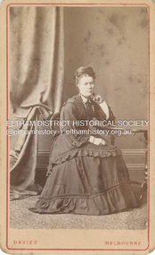
Photograph, Davies & Co, Sarah Shillinglaw, c.1870
Married Charles Aldous 9 Jun 1880. In this picture Sarah does not appear with a wedding ring. Inscribed on reverse with errors [actual] B. 9 Nov. 1855 [9 Nov. 1854] M. 9 Jun. 1880 [Charles Aldous] D. 25 Jan. 1925 aged 71 [ 3 Aug. 1925] ALDOUS.—On the 3rd August, at her residence, 14 Mitchell street, Northcote, Sarah, dearly be- loved wife of Charles, mother of Florrie (Mrs. Beere), Annie (Mrs. Mooney), Percy (deceased, late A.I.F.), Ada (Mrs. Wilson), Alice (de- ceased), Ethel (Mrs. Brien), aged 70 years 9 months. A patient sufferer at rest. Family Notices (1925, August 4). The Argus (Melbourne, Vic. : 1848 - 1957), p. 1. Retrieved December 6, 2022, from http://nla.gov.au/nla.news-article2150744 Davies & Co (William Davies) operated from: 7 Bourke Street East 1867-1869 55 Bourke Street East 1874-1877 55 Bourke Street East as Central Photogrphic Studio (E. Sands Mgr) 1878-1884 73 Bourke Street East 1877 91 Bourke Street East 1864-1868 94 Bourke Street East 1864-1877 98 Bourke Street East 1860-1861 19 Collins Street East 1865-1868 5 Collins Street West 1866-1870 CARTE-DE-VISITE (cdv) 1857-1890 Cartes-de-visite (cdv's) are the most common form of photograph from the nineteenth century, generally measuring two and a half inches by four and an eighth inches (6.3 x 10.5 cm) when mounted, sepia toned, mounted on a card which was generally printed with the photographer's name and address on the back or beneath the portrait. - Frost, Lenore; Dating Family Photos 1850-1920; Valiant Press Pty. Ltd., Berwick, Victoria 1991marg ball collection, 1860-1877, 1870, davies photographer melbourne, pagoda sleeves, sarah aldous (nee shillinglaw 1854-1925), shillinglaw family photo album 2 -
 Eltham District Historical Society Inc
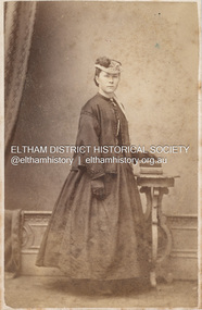
Photograph, Davies & Co, Believed to be Sarah Shillinglaw, c.1869
Sarah Shillinglaw was born at River Plenty on November 9, 1854. She married Charles Aldous on June 9, 1880 and died in Prahran, Victoria on August 3, 1925. Davies & Co (William Davies) operated from: 7 Bourke Street East 1867-1869 55 Bourke Street East 1874-1877 55 Bourke Street East as Central Photogrphic Studio (E. Sands Mgr) 1878-1884 73 Bourke Street East 1877 91 Bourke Street East 1864-1868 94 Bourke Street East 1864-1877 98 Bourke Street East 1860-1861 19 Collins Street East 1865-1868 5 Collins Street West 1866-1870 CARTE-DE-VISITE (cdv) 1857-1890 Cartes-de-visite (cdv's) are the most common form of photograph from the nineteenth century, generally measuring two and a half inches by four and an eighth inches (6.3 x 10.5 cm) when mounted, sepia toned, mounted on a card which was generally printed with the photographer's name and address on the back or beneath the portrait. - Frost, Lenore; Dating Family Photos 1850-1920; Valiant Press Pty. Ltd., Berwick, Victoria 1991marg ball collection, 1867-1869, 1869, davies & co post office photographic studio 7 bourke st east melbourne, paletot jacket, post office photographic studio, sarah aldous (nee shillinglaw 1854-1925), shillinglaw family photo album 2, unknown -
 Eltham District Historical Society Inc
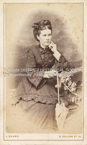
Photograph, James Sharp, Sarah Shillinglaw, c.1875
Married Charles Aldous 9 Jun 1880. In this picture Sarah does not appear with a wedding ring. Photographer James Sharp operated from 5 Collins Street West from 1872-1876 CARTE-DE-VISITE (cdv) 1857-1890 Cartes-de-visite (cdv's) are the most common form of photograph from the nineteenth century, generally measuring two and a half inches by four and an eighth inches (6.3 x 10.5 cm) when mounted, sepia toned, mounted on a card which was generally printed with the photographer's name and address on the back or beneath the portrait. - Frost, Lenore; Dating Family Photos 1850-1920; Valiant Press Pty. Ltd., Berwick, Victoria 1991marg ball collection, 1872-1876, 1875, j. sharp photographer 5 collins st west melbourne, sarah aldous (nee shillinglaw 1854-1925), shillinglaw family photo album 2 -
 Eltham District Historical Society Inc
Document - Folder, McLean, 1984-1999
References to McLean family, Hector John McLean and Louisa Frances (nee Green) and six daughters who lived in Eltham during the period 1930 to 1934 inclusive. Lived in the former Evelyn Hotel at the time it was destroyed by fire and being part of the Centenary Parade in 1934 where the family won the Group Section for their entry “Pioneers of Eltham” Reminiscences provided by Edith Jones (nee M1934 flood, ballroom, baptism, barber shop, bittern, boy scouts, bremner's flat, burgoyne's shop, cable tram, cemetery road, centenary celebrations, centenary parade, christening, coach house, collis grocery, dalton street, depression, dole, dorothy jean mclean, edith jones (nee mclean), eltham fire brigade, eltham high school, eltham higher elementary school, eltham lower park, eltham railway station, eltham state school no. 209, evelyn hotel, fire damage - buildings, flinders naval depot, fordham, gladys evelyn mclean, gold mining, gwenneth mae mclean, gwladys evelyn mclean, headmistress, hector john mclean, isherwood house and shop, louisa frances mclean (nee green), metery road, methodist church, miss finnin, miss grant cottage, motor bike races, mrs barrett, mrs bremner, mrs hurley, olive isabel mclean, parade, phoebe lillian mclean, picnic, pioneers of eltham, pitt street, research fire brigade, rev. r.g. arthur, shed, shops, st margarets church hall, st margaret's church, stables, state savings bank of victoria, susso books, todaro, vinnie willet, warrandyte bridge, warrandyte, wingrove park, yarra river -
 Eltham District Historical Society Inc
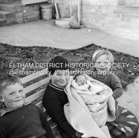
Negative - Photograph, J.A. McDonald, Unidentified children, Sep. 1959
Believed to be four children all of the same family, most probably those of an Eltham Shire Council employee who worked for the Engineering department (see image 05584-8)Record of various Shire of Eltham infrastructure works undertaken during the period of 1952-1962 involving bridge and road reconstruction projects, sometimes with Eltham Shire Council Project Reference numbers quoted. It was during this period that a number of significant improvements were made to roads and new bridges constructed within the shire that remain in place as of present day (2022). In many situations, the photos provide a tangible visible record of infrastructure that existed throughout the early days of the Shire. The album was put together by or under the direction of the Shire Engineer, J.A. McDonald.shire of eltham, 1959-09, children -
 Eltham District Historical Society Inc
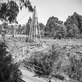
Negative - Photograph, J.A. McDonald, Laidlays Road, Arthurs Creek, April 1962
Bridge over Arthurs Creek Looking east April 1962Record of various Shire of Eltham infrastructure works undertaken during the period of 1952-1962 involving bridge and road reconstruction projects, sometimes with Eltham Shire Council Project Reference numbers quoted. It was during this period that a number of significant improvements were made to roads and new bridges constructed within the shire that remain in place as of present day (2022). In many situations, the photos provide a tangible visible record of infrastructure that existed throughout the early days of the Shire. The album was put together by or under the direction of the Shire Engineer, J.A. McDonald.1962-04, arthurs creek, bridge construction, infrastructure, laidlays road, shire of eltham -
 Eltham District Historical Society Inc
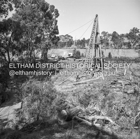
Negative - Photograph, J.A. McDonald, Laidlays Road, Arthurs Creek, April 1962
Bridge over Arthurs Creek Looking east April 1962Record of various Shire of Eltham infrastructure works undertaken during the period of 1952-1962 involving bridge and road reconstruction projects, sometimes with Eltham Shire Council Project Reference numbers quoted. It was during this period that a number of significant improvements were made to roads and new bridges constructed within the shire that remain in place as of present day (2022). In many situations, the photos provide a tangible visible record of infrastructure that existed throughout the early days of the Shire. The album was put together by or under the direction of the Shire Engineer, J.A. McDonald.1962-04, arthurs creek, bridge construction, infrastructure, laidlays road, shire of eltham -
 Eltham District Historical Society Inc
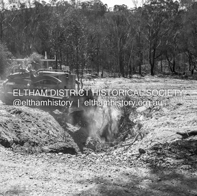
Negative - Photograph, J.A. McDonald, Buttermans Track, St Andrews, April 1962
LR Bassett P/L filling in scour on Crosby's property Circa April 1962Record of various Shire of Eltham infrastructure works undertaken during the period of 1952-1962 involving bridge and road reconstruction projects, sometimes with Eltham Shire Council Project Reference numbers quoted. It was during this period that a number of significant improvements were made to roads and new bridges constructed within the shire that remain in place as of present day (2022). In many situations, the photos provide a tangible visible record of infrastructure that existed throughout the early days of the Shire. The album was put together by or under the direction of the Shire Engineer, J.A. McDonald.1962-04, bridge construction, buttermans track, flood damage, infrastructure, shire of eltham, st andrews