Showing 35210 items matching "healesville-shire-council"
-
 Federation University Historical Collection
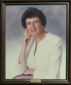
Photograph - Portrait, Ballarat School of Mines Council President: Kerrie Lynette Cross, 1988-1991, c1991
Kerrie Cross was president of the Ballarat School of MInes School Council. She was a member of the Council from 1985 to 1992. She was the President from 1988 to 1991.Framed coloured photograph on canvas of Kerrie Lynette Cross in a white outfitBrass plaque attached to frame: "Kerrie Lynette Cross Member SMB Council 1985-1992 President 1988-1991"president, ballarat school of mines, kerrie cross, school council, available, university women -
 Stawell Historical Society Inc
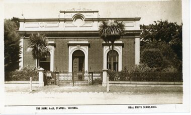
Photograph, Stawell Shire Hall 1866
Post card of the Stawell Shire Hall built 1866. The Shire Hall in Longfield Street Stawell has seen many changes over time. The building originally had a brick facade as seen in this photo. The post card also shows the changes in vegetation around the building. In front of the two arched front windows of the building are two tall Dracaena's possible planted in c 1890's. The decorative fence was not in very early photographs of the building but appears in photographs around c 1890. The post card is located in Albun 14, p.9.Black & white post card of the Stawell Shire Hall. The building has a brick facade with trees in the background. In front of the two arched front windows of the building are two tall Dracaena's either side of the entrance. There is a decorative fence with posts either side of the entrance gates to the building. The post card is located in Albun 14, p.9.The Shire Hall, Stawell Victoria. Real Photo Series. M. 672. on the back Valentines real photo series POST CARD branches Sydney London Dundee Capetown Montreal Toronto all in a box. Published by the Valentine & Sons Publishing Co.Ltd. Melbourne, Sydney & Brisbane.stawell -
 Clunes Museum
Document - REPORT, HISTORY CLUNES BOROUGH COUNCIL 1860 - 1965
HISTORY OF CLUNES BOROUGH COUNCIL 1860 - 1965 COMPILED BY MR. F.C. WEICKHARDT 1975PHOTO COPY OF THE CONTENTS FROM A FOLER CONTAINING HISTORY CLUNES BOROUGH COUNCIL 1860 - 1965. COMPILED BY MR. F.C. WEICKHARDT.local history, document, local government, weickhardt, talbot & clunes shire council -
Bialik College
Archive (Item) - Meg Rynderman Collection Box 7, Meg Rynderman Collection, Council Papers and Reports, 1985-2004
Council Reports and research reports associated with Bialik College from 1986 to 2004. Private and confidential. For access, or to check the availability of this record please contact the archive at [email protected]. bialik council, meg rynderman, reports, 1980s, 1990s, 2000s -
Stawell Historical Society Inc
Medallion, Victoria Jubilee 1887 Shire of Stawell, 1867
Commemorative item of Queen Victoria's Jubilee. Issued by Stawell shire. May have been given to school Children.Tarnished Medallion "Brass"Obverse - Victoria Jubilee 1887 - Young Head Left Profile. Reverse - Shire of Stawell T.H. Hutchings J.P President [Raised engraving of the Shire Hall]queen victoria jubilee -
 Bendigo Military Museum
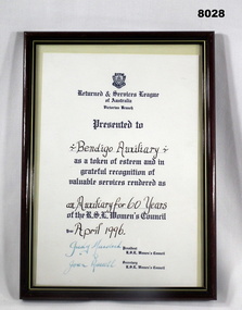
Certificate - WOMENS AUXILIARY 60 YEARS, Vic RSL Women’s Council, C.1996
Refer Cat 8021 for details re Bendigo Women’s Auxiliary.Framed certificate, frame is plastic, black with gold colour edge, certificate whitish background, all print blue and black, at the top badge of “RSL Women’s Council of Victoria” followed by details of the certificate.Main points. “Presented to Bendigo Auxiliary as a token of esteem and in grateful recognition of valuable services rendered as an Auxiliary for 60 years of the RSL Women’s Council” - “Year 1996” “Judy Murdoch - President RSL Women’s Council” “Joan Russell - Secretary RSL Women’s Council”brsl, smirsl, auxiliary, wabrsl -
 Rutherglen Historical Society
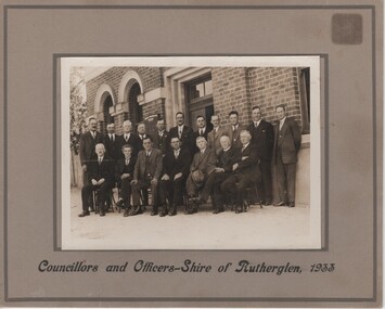
Photograph, 1933 (Exact)
Rutherglen Shire CouncilPhotograph of shire councillors in front of shire office 1933On bottom of frame beneath photo: "Councillors and Officers - Rutherglen Shire, 1933" On verso: "Back row / Crs. J.L. Jackson, S.P. Diffey, Walter McRae, Percy Lingford (Engineer), S.G. Williams, J. Milthorpe, C. Ricketts (Shire Secretary), L. Tobbon, J. Terril, W.B. McDonald, W. H. Turner (Rutherglen Sun)" "Front row / John Burch, Roy Ready, CH. Morris, Frank Fuge, D.B. Smith, Martin Graham, W.H. Chambers"j l jackson, s p diffey, walter mcrae, percy lingford, s g williams, j milthorpe, c ricketts, l tobbon, j terril, w b mcdonald, w h turner, john burch, roy ready, c h morris, frank fuge, d b smith, martin graham, w h chambers -
Whitehorse Historical Society Inc.
Document - Correspondence, Healesville Road, 1/09/1937
Claim for reimbursement from Country Roads Board for amounts expended on the Burwood Road by Shire of Blackburn and Mitcham.burwood road, roads and streets, shire of blackburn and mitcham, victoria. country roads board -
 Linton and District Historical Society Inc
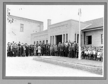
Photograph, Hornby Studio Ballarat, Crowd outside new Shire of Grenville building for opening of new Shire Offices in 1939
Black and white photograph of a crowd of men, women and children posed outside a brick building."New Shire hall".buildings, grenville shire council, shire offices linton, events -
 Federation University Historical Collection
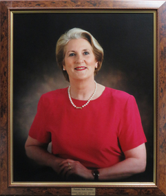
Photograph - Photograph - coloured, SMB Council President: Pamela Ruth Davies, 1996-1997, c1996
Pamela Davies was the first female president of the Ballarat School of MInes School Council. She was a member of the Council from 1989 to 1996 and then became the President from 1996 to 1997.Framed coloured photograph on canvas of Pamela Davies in a red dress and pearlsBrass plaque attached to frame: "Pamela Ruth Davies Member SMB Council 1989-1996 President 1996-1997"pamela davies, president, ballarat school of mines, pam davies, university women -
 Stawell Historical Society Inc
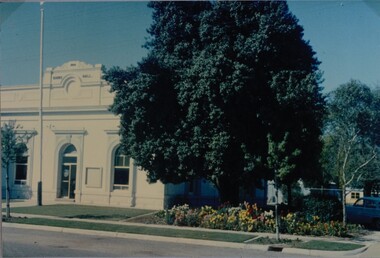
Photograph, Stawell Shire Hall -- Coloured
Stawell Shire Hall photograph taken around the same time as 84.13. Image shows the building painted white with no decorative fence out the front.View from the street of Stawell Shire Hall. The image is taken from the right hand side of the building showing a colourful flower bed in front of a large tree. The flag post is also out the front of the Shire Hall. stawell -
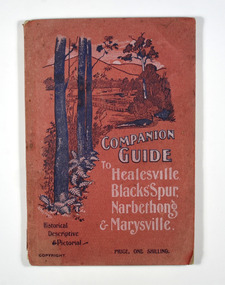
 Marysville & District Historical Society
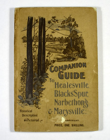
Book, The Atlas Press, Companion Guide to Healesville, Blacks' Spur, Narbethong & Marysville, 1904
A companion guide to Healesville, Blacks' Spur, Narbethong & Marysville. With photographs, information and a pull-out map.Paperback. Front cover has a drawing of a countryside outlook. The book contains 65 photographs and information relating to the locations listed on the front cover. There is a pull-out map located on the inside of the back cover.non-fictionA companion guide to Healesville, Blacks' Spur, Narbethong & Marysville. With photographs, information and a pull-out map.healesville, black spur, narbethong, marysville, victoria, history -
 Marysville & District Historical Society
Book, The Atlas Press, Companion Guide to Healesville, Blacks' Spur, Narbethong & Marysville, 1904
A companion guide to Healesville, Blacks' Spur, Narbethong & Marysville. With photographs, information and a pull-out map.Paperback. Front cover has a drawing of a countryside outlook. The book contains 65 photographs and information relating to the locations listed on the front cover. There is a pull-out map located on the inside of the back cover. Back cover has details of the rail and coach services available to travel to the destinations mentioned in the book. non-fictionA companion guide to Healesville, Blacks' Spur, Narbethong & Marysville. With photographs, information and a pull-out map.healesville, black spur, narbethong, marysville, victoria, history -
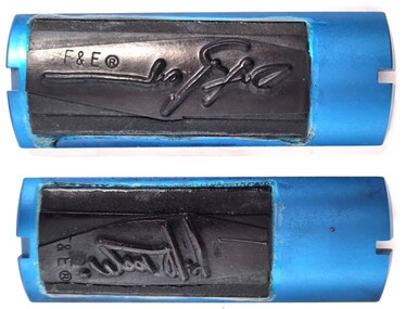 Wodonga & District Historical Society Inc
Functional object - Wodonga Council Cheque Signing Plates
These signature stamps were used by Ray O’Toole and Des Packer in their roles on Wodonga Council. Mr Ray O'Toole worked at Prahran, Springvale, Keilor and Yarrawonga Councils before joining Wodonga as Chief Clerk and accountant in 1972. In 1973, Mr O'Toole became Deputy Town Clerk and was appointed as the Chief Executive Officer in 1980. He retired from that role in1994 when all local governments throughout Victoria were dissolved by the Kennett government in a major reorganisation. Ray was elected as a Councillor to the newly formed Council in 1997 and served until 2005. He died in Wodonga on 2nd August 2022. Des Packer was appointed as Finance Director of Wodonga Council in July 1989 after previously serving as Deputy Town Clerk.This item is significant because it documents key officers in the Wodonga City Council.Two rubber signature stamps attached to metal backing strip. These stamps would be attached to a handle to apply signatures to Wodonga Council cheques.wodonga city council, ray o'toole, des packer -
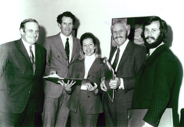 Federation University Historical Collection
Photograph - Photograph - Black and White, State Council of Victoria at Ballarat Council, 1973, 10/08/1973
The State College Victoria at Ballarat was formerly the Ballarat Teachers' College. Four men and a woman are photographed. The inaugural Council of State College Victoria at Ballarat - (Left to Right) Ian Gordon, John Vernon, Janet Torney, Bob Croft and Geoff Hendy (Secretary to Council).state council of victoria at ballarat council, scvb, ballarat teachers' college, ian gordon, john vernon, janet torney, bob croft, geoff hendy, university women -
Federation University Historical Collection
Booklet, Report of the Sixteenth Meeting of the Federal Council of the Boilermakers' Society if Australia, 1952, 1952
Sixteenth meeting of the Federal Council of Boilermakers' Society of AustraliaSmall buff soft covered booklet of 41 pages relating to the Federal Council of Boilermakers' Society of Australia meeting at at the Railway Institute, Perth, Western Australia.federal council of boilermakers' society of australia, boilermakers, a. barty, s. willis, s. wookey, world peace, opposition to war, recall of troops from korea, cessation of immigration, schuman plan, coal mining award, industrial deafness, unions -
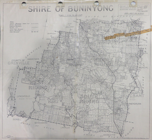 Federation University Historical Collection
Map, Shire of Buninyong, c1970
The Shire of Buninyong was located on the southern side of Ballarat.Two maps of the Shire of Buninyong. .1) Map showing the County divisions, township boundaries, Railway line, State Forest boundary, riding boundary and shire boundary. Identifying words have been added in red and green texta. .2) Shire of Buninyong Parish Plan. Includes Buninyong, Clarendon, Narmbool, Enfield, Lychfield, SCotchman's, Navigators, Warrenheip, Scotsburn, mr Doran, Durham Lead, Cambrian Hill, Napoleons, Garibaldi, Mt Clear, Lal Lal, Bonshaw.1) B.I.A.E., St Martin's, cemetery, mt Buninyong, mt Innes, rly stn shire of buninyong, buninyong, clarendon, narmbool, enfield, lychfield, scotchman's, navigators, warrenheip, scotsburn, mt doran, durham lead, cambrian hill, napoleons, garibaldi, mt clear, lal lal, bonshaw, state forest, elaine, elaine north, cargerie, grenville, mt mercer, millbrook, wallace, yendon, canadian, kaolin deposits, mount helen campus -
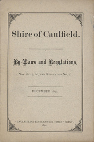 Glen Eira City Council History and Heritage Collection
Booklet, "Shire of Caulfield. By-Laws and Regulations, Nos 18, 19, 20 and Regulation No.2. December 1892.", c. 1892
Paper pamphlet generated by Council in December 1892 for the purpose of regulating the control of The Common Seal of the Municipality.Booklet titled "Shire of Caulfield. By-Laws and Regulations, Nos 18, 19, 20 and Regulation No.2. December 1892." Comprising 11 pages of double-sided, black printed text and a greyish colour paper cover with title and printers details printed on the cover. The interior pages are cream coloured and numbered at the top. Paper document commissioned by the Shire of Caulfield to list Shire By-Laws and Regulations. -
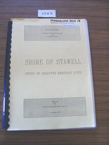 Stawell Historical Society Inc
Book, Tom Hutchison & Denise Thorson, Shire of Stawell - Study of Selected Heritage Sites, 1994
This report is a re-evaluation of the Historical Survey: Shire of Stawell as undertaken by the Stawell and Halls Gap Historical Societies in June 1990.Yellow Card cover with black print and black plastic bindingFinal Document Prepared for the Shire of Stawell and Heritage Victoria Shire of Stawell Study of Selected Heritage Sites Prepared by Tom Hutchison and Denise Thornson November 1994stawell heritage -
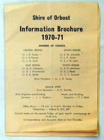 Orbost & District Historical Society
brochures, Snowy River Mail as "Mail" Print, Shire of Orbost Information Brochure, December 1970
The Shire of Orbost was a local government area about 380 kilometres east of Melbourne, the state capital of Victoria, Australia. The shire covered an area of 9,347 square kilometres ), and existed from 1892 until 1994. Originally, Orbost was part of the Bairnsdale Road District which was created on 30 April 1867. Splitting away as part of the Shire of Tambo in 1882, Orbost was first incorporated as a shire in its own right as the Shire of Croajingolong on 30 May 1892. It received its present name on 17 February 1893. On 3 January 1913 part of its western riding was annexed to Tambo as its Cunninghame Riding. On 2 December 1994, the Shire was abolished, and merged with City and Shire of Bairnsdale, Shire of Tambo, most of Shire of Omeo and the Boole Boole Peninsula from Shire of Rosedale into the Shire of East Gippsland This is a useful research tool.Two copies of a triple fold paper brochure. It is titled"Shire of Orbost Information Brochure" in black print. It contains the names of councillors, staff, the work program and budget.shire-of-orbost -
Whitehorse Historical Society Inc.
Letter - Correspondence, Shire of Blackburn and Mitcham - T. Nielson, 1930
Letter - Shire of Blackburn and Mitcham expresses its appreciation of services rendered to council by Miss B. Nielson, a representative of the 'Reporter' newspaper, and wishing her success in her new position.Letter - Shire of Blackburn and Mitcham expresses its appreciation of services rendered to council by Miss B. Nielson, a representative of the 'Reporter' newspaper, and wishing her success in her new position.Letter - Shire of Blackburn and Mitcham expresses its appreciation of services rendered to council by Miss B. Nielson, a representative of the 'Reporter' newspaper, and wishing her success in her new position.local government, shire of blackburn and mitcham, nielson, beatrice, bishop, herbert thomas -
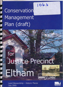 Eltham District Historical Society Inc
Book, Ivar Nelsen, Conservation Management Plan (draft) for Justice Precinct Eltham (July 2005) prepared for Nillumbik Shire, 2006
Draft for report on guidance on the heritage issues in the management of the court house and former police buildings of the early justice precinct at Eltham.39 p, 30 cm.Harry Gilham E.D.H.S. Inc.eltham justice precinct, justice precinct eltham -
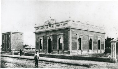 Stawell Historical Society Inc
Photograph, Stawell Shire Hall 1866
This photograph is a copy obtained from State Library of Victoria. The photograph is of Stawell Shire Hall. Two persons can be seen in the foreground. The two story brick building beside the Stawell Shire Hall was once the Literary Institute. The Stawell Shire Hall building has been added to over the years. Ronald Campbell, the Shires second president laid the foundation stone on 28th April. 1866. The contractors were Hutchings and Delbridge. The photograph shows the first hall and office. The building contained simple 18 feet square rooms, with an entrance hall separating them, the facade was almost as it is now. The initial cost of the Shire Hall was $502.Black and white photograph of Stawell Shire Hall as one single storey brick building with parapet on top. Beside the Shire Hall is a two storey brick building. Also, a dwelling between the two building in the background in Cooper St. Two persons in the foreground, one on the road the other on the pathway. stawell -
 Eltham District Historical Society Inc
Photograph, Tess Justine (Nillumbik Shire Council), Construction work on replacement of Murray's Bridge over the Diamond Creek, Eltham North, 31 Mar 2022
Construction work on replacement of Murray's Bridge over the Diamond Creek on the Diamond Creek Trail Mary (Sweeney) Murray and John Wright Murray selected 80 acres, Lot C Section 16 and Lot 5 Section 17 Parish of Nillumbik, under an occupation license in 1866. John died in 1867 and freehold was granted to his son John in 1873. The farm was known as ‘Laurel Hill’. John Junior was an Eltham Shire councillor and sometime president from 1887 up until 1897. He added Lot A Section 16 to the farm in ca1888. John and his younger brother James arranged to rent/purchase Lot B Section 17, across Diamond Creek to the west, in ca1900. It appears that John and James farmed separately for a few years, with a new homestead built for James ad family on the high point of Lot B Section 17 in ca1910. John sold off Lot 5 Section 17 in 1912. When John died in 1912 James took over the land on both sides of the Diamond Creek. The old homestead on the west side of the Creek disappeared. A farm bridge over Diamond Creek from this period may have been located close to the northern boundary of the farm. John Langlands, owner of the farm known as ‘Ihurst’ on the west side of Diamond Creek to the south of the Murray’s land, died in 1907. In 1909 his land was then subdivided into 100 lots to become the ‘Glen Park Estate’. Other similar subdivisions of nineteenth century farms around Eltham in this period included the ‘Franktonia (or Beard’s) Estate’ to the northeast and ‘Bonsack’s Estate’ between Eltham and Greensborough. Soon after the opening of the railway extension line from Eltham to Hurstbridge in 1912, Glen Park and nearby residents including James Murray agitated for a railway station or siding to be located half-way between Eltham and Hurstbridge, so that the Glen Park residents who used the railway daily did not have to walk into the Eltham or Hurstbridge stations. Some believed Coleman’s Corner (opposite Edendale Farm) was an appropriate spot for the platform. James Murray was among those who thought the railway should be located on his land, closer to half-way between Eltham and Hurstbridge stations. The Railways Commissioners warned that the locals would have to fund these works themselves. The Glen Park Estate residents initially had difficulty accessing Eltham by road, with only an old low-level bridge over Diamond Creek at the south end of their estate. A new timber trestle bridge across the creek, now on Wattletree Road, was opened in 1915. Road access to the north was gained in 1927 when the new Murray’s Road, which crossed the Murray’s land, was built. Residents continued to agitate for a Glen Park station. By 1926 the Railways Commissioners’ preferred site was on the Murray’s land. They arranged an estimate of cost of a full-length platform. The estimate was too much for the locals, who in 1928 argued unsuccessfully for a shorter and hence cheaper platform. By 1929 Murray had agreed to donate the land, but the locals would still have to fund the works. Murray decided, unilaterally it would appear, to commence work on a timber trestle road bridge over Diamond Creek to link the new Murray Road to the proposed station. Late in 1929 he stopped work on the bridge, for reasons unknown, but started work again and completed the bridge in 1931. There is no further newspaper evidence of the campaign for the Glen Park station until 1939, when Murray and another local, Mr Maxwell, met the Railways Commissioner. The Glen Park locale now included 45 homes on the west side of the creek and 20 on the Eltham side. Most of the residents used the train every day. The Commissioner remained adamant that only a full-length platform could be built for safety reasons. It appears the campaign dissolved at this point. The increasing move to cars may have had an impact. There is no evidence of Murray’s bridge ever being connected to Murray’s Road, or of it having wide use for any purpose by locals. James Murray died in 1947 and the farm was taken over by his son James (Jim). Jim started to sell off parts of the farm in the 1980s, retaining a few acres around the ca1910 homestead and building a new house there. Recreation reserves were established along the creek. In ca1990 Murray’s bridge was renovated with steel girders as part of a bike/pedestrian path in the reserve. The old farmhouse was demolished in ca2014. Born digital image (5)diamond creek (creek), diamond creek trail, murrays bridge, ‘laurel hill’, john wright murray, mary (sweeney) murra, john murray jnr, james murray, john langlands, ‘ihurst’, ‘glen park estate’, beard's estate, franktonia, bonsack's estate, glen park estate, glen park railway station -
 Eltham District Historical Society Inc
Photograph, C.S. Wingrove, Secretary, Eltham District Road Board 1858-1871; Shire Secretary, Shire of Eltham 1871-1904, 1858-1871
Charles Symons Wingrove, J.P. (1829-1905) arrived in Victorian in 1851. He had trained as an engineer, but tried his luck on the goldfields. In 1857 he was appointed as Secretary to the Eltham District Roads Board only one year after its foundation. He was to hold the position with the Board and later the Eltham Shire Council for total of 47 years. He also held the position of engineer for a large part of this period. During part of this time he was also secretary to the Heidelberg Shire Council. Over this period he was responsibly for an area stretching from Clifton Hill to Healesville, along the northern bank of the Yarra River. Other positions included Secretary to the Victorian Agricultural Society over along period.Wingrove was a main figure in the Municipal Association of Victoria. By the time he retired he was recognized as the “Grand Old Man” of Victorian local government. In 1858 Wingrove had a brick cottage built in Main Road near the State School and he lived here until his death. One room was uded as the Board and Council office. His descendants owned the house until 1974. It was later used as a psychiatric clinic. The park opposite the cottage has been named Wingrove Park in his honour. He is buried at St Helena with other members of his family. Age (Melbourne, Vic. : 1854 - 1954), Tuesday 18 July 1905, page 5 ABOUT PEOPLE. A conspicuous figure in northern municpal history, Mr. Charles Symons Wingrove, has passed away. He was for many years secretary and engineer for the shire of Eltham, and prior to the formation of the shire held the position under the old road board, his official connection with the district dating from beyond 1857. For about twelve years he also filled the position of shire engineer for Heidelberg council while retaining his other post, and the immense territory under his professional control, reaching from the boundary of Collingwood up to Healesville, was a matter of fatherly pride and interest to him. He arrived in Victoria in 1851, and was 76 years of age at his death. Mr. Wingrove retired from the position in the Eltham council only about a year ago. The interment will take place in St. Helena Cemetery, near Eltham township, today. Secretary, Eltham District Road Board 1858-1871 Secretary for the Shire of Eltham 1871-1904. Nearly 50 years service to the local community. For about twelve years he also filled the position of shire engineer for Heidelberg council. Reproduced Page 137 "Pioneers & Painters" This photo forms part of a collection of photographs gathered by the Shire of Eltham for their centenary project book,"Pioneers and Painters: 100 years of the Shire of Eltham" by Alan Marshall (1971). The collection of over 500 images is held in partnership between Eltham District Historical Society and Yarra Plenty Regional Library (Eltham Library) and is now formally known as the 'The Shire of Eltham Pioneers Photograph Collection.' It is significant in being the first community sourced collection representing the places and people of the Shire's first one hundred years.Digital image Print 25 x 20 cmc.s.wingrove, charles symons wingrove, eltham district road board, sepp, shire of eltham pioneers photograph collection, shire secretary, wingrove cottage, pioneers and painters, shire of eltham, councilor, municipal officer -
Glenelg Shire Council Cultural Collection
Book, Glenelg Shire, 150 Years in the Making, 2014
a) Book, Glenelg Shire, 150 Years in the Making. Produced by Glenelg Shire Council, launched July 2014. Card cover, views of early Portland front and back covers, sepia tones, Glenelg Shire logo on front. Black print, black and white and coloured photographs. Signed on the fly-leaf by the then premier of Victoria, Denis Napthine. 'Congrats to Glenelg Shire 150 years in the Making. Well done, Denis Napthine PREMIER July 2014' b) Envelope for the booklocal history, history of the glenelg shire, victoria, denis napthine -
 Ringwood and District Historical Society
Document, From Borough of Ringwood Council, agenda for next council meeting on 23 July 1929
1929 saw the establishment of the Ringwood Bowls Club initially located on the land now occupied by the Eastland Shopping Centre. It moved to its current location in Loughnan Road, Ringwood in 1997.From Borough of Ringwood Council, agenda for next council meeting on 23 July 1929. Ringwood Bowling Club requesting conditions for use of Bamford Park as a bowling green.city of ringwood bowls club, ringwood bowling club, ringwood bowls club, lawn bowls, bowling -
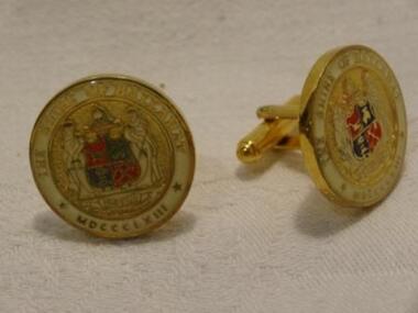 Learmonth and District Historical Society Inc.
Cuff Links -Shire of Ballarat, Circa late 20th Century
These Cuff Links were possibly worn by members of the Shire Council,and may also have been given as gifts to visiting personell. Enamelled round Cuff Links showing the Coat of Arms of the Shire of Ballarat, set in a gold base and gold Anchors.THE SHIRE OF BALLARAT,MDCCCLX111, PREAVIUS.jewellary cufflinks -
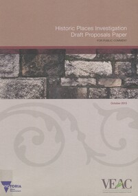 Surrey Hills Historical Society Collection
Book, Historic Places Investigation Draft Proposals Paper, 2015
Draft Proposals paper for Victorian Environmental Assessment Council's (VEAC) Historic Places investigation, written for community consultation purposes.Draft Proposals paper for Victorian Environmental Assessment Council's (VEAC) Historic Places investigation, written for community consultation purposes. colour illus. mapshistory buildings, historic sites, public lands -
Whitehorse Historical Society Inc.
Document, Certificate - Shire of Nunawading, 1914
Photocopies of (a) certificate of election of Councillor Walter Redman as President of the Shire of Nunawading, 4 Sep 1914 & (b) a letter of congratulations to Cr Redman from Robert Beckett, Legislative Council of Victoria.Photocopies of (a) certificate of election of Councillor Walter Redman as President of the Shire of Nunawading, 4 Sep 1914 & (b) a letter of congratulations to Cr Redman from Robert Beckett, Legislative Council of Victoria.Photocopies of (a) certificate of election of Councillor Walter Redman as President of the Shire of Nunawading, 4 Sep 1914 & (b) a letter of congratulations to Cr Redman from Robert Beckett, Legislative Council of Victoria.politics and government, shire of nunawading, redman, walter, victoria. legislative council, beckett, robert