Showing 1655 items matching "junctions"
-
 Kew Historical Society Inc
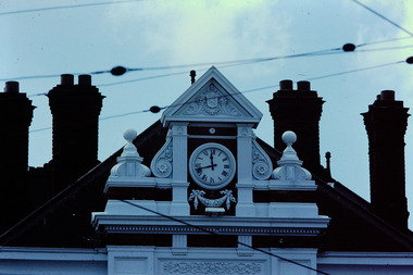
Slide - Central Pediment: Kew Post Office, 1980
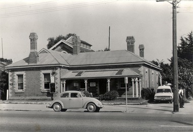
A civic campaign for new public offices developed in Kew in the 1880s. After much deliberation, the location chosen was the junction of Bulleen and Cotham Roads. The buildings were designed by George Watson and John Henry Harvey, architects within the Department of Public Works (Victoria). Building was commenced in 1887, and after one year, the buildings were opened. The Post Office was transferred to the new Commonwealth Government in 1901. The Police Station and Court House, sold by the Victorian Government to the City of Boroondara in 2007, are now a community cultural centre and performing arts venue.The buildings were listed on the Victorian Heritage Register Register (HO885) in 1991. They are historically and architecturally significant to the State of Victoria because Watson and Harvey's designs exhibit diversity in integrating civil offices, they accommodate the apex of road junctions, and they demonstrate a departure from the contemporaneously favoured High Victorian Classical to the Queen Anne style in the design of civic buildings. 35mm colour transparency of the central pediment, clock and chimneys of the Kew Post Office on the corner of High Street and Cotham Road. The [former] post office is a significant example of the English Queen Anne Revival style. The photograph was taken as part of a series by Ralph Andrews (Department of Building, RMIT) in April 1980.kew post office, khs - slides, new public offices -- kew (vic.), architectural styles -- english queen anne revival -
 Kew Historical Society Inc
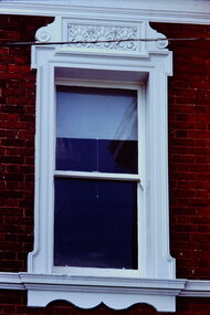
Slide - Window: Kew Post Office, 1980
A civic campaign for new public offices developed in Kew in the 1880s. After much deliberation, the location chosen was the junction of Bulleen and Cotham Roads. The buildings were designed by George Watson and John Henry Harvey, architects within the Department of Public Works (Victoria). Building was commenced in 1887, and after one year, the buildings were opened. The Post Office was transferred to the new Commonwealth Government in 1901. The Police Station and Court House, sold by the Victorian Government to the City of Boroondara in 2007, are now a community cultural centre and performing arts venue.The buildings were listed on the Victorian Heritage Register Register (HO885) in 1991. They are historically and architecturally significant to the State of Victoria because Watson and Harvey's designs exhibit diversity in integrating civil offices, they accommodate the apex of road junctions, and they demonstrate a departure from the contemporaneously favoured High Victorian Classical to the Queen Anne style in the design of civic buildings. 35mm colour transparency of the ornamental stucco treatment of a window of the Kew Post Office on the corner of High Street and Cotham Road. The [former] post office is a significant example of the English Queen Anne Revival style. The photograph was taken as part of a series by Ralph Andrews (Department of Building, RMIT) in April 1980.kew post office, khs - slides, new public offices -- kew (vic.), architectural styles -- english queen anne revival -
 Kew Historical Society Inc
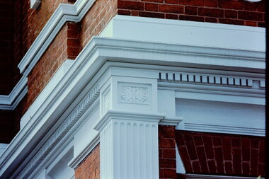
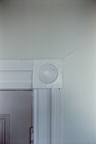
Slide - Decorative Stucco: Kew Post Office, 1980
A civic campaign for new public offices developed in Kew in the 1880s. After much deliberation, the location chosen was the junction of Bulleen and Cotham Roads. The buildings were designed by George Watson and John Henry Harvey, architects within the Department of Public Works (Victoria). Building was commenced in 1887, and after one year, the buildings were opened. The Post Office was transferred to the new Commonwealth Government in 1901. The Police Station and Court House, sold by the Victorian Government to the City of Boroondara in 2007, are now a community cultural centre and performing arts venue.The buildings were listed on the Victorian Heritage Register Register (HO885) in 1991. They are historically and architecturally significant to the State of Victoria because Watson and Harvey's designs exhibit diversity in integrating civil offices, they accommodate the apex of road junctions, and they demonstrate a departure from the contemporaneously favoured High Victorian Classical to the Queen Anne style in the design of civic buildings. 35mm colour transparency of the decorative stucco treatment of architectural elements of the Kew Post Office on the corner of High Street and Cotham Road. The [former] post office is a significant example of the English Queen Anne Revival style. The photograph was taken as part of a series by Ralph Andrews (Department of Building, RMIT) in April 1980.kew post office, khs - slides, new public offices -- kew (vic.), architectural styles -- english queen anne revival -
 Kew Historical Society Inc
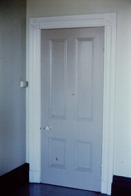
Slide - Kew Post Office, 1980
A civic campaign for new public offices developed in Kew in the 1880s. After much deliberation, the location chosen was the junction of Bulleen and Cotham Roads. The buildings were designed by George Watson and John Henry Harvey, architects within the Department of Public Works (Victoria). Building was commenced in 1887, and after one year, the buildings were opened. The Post Office was transferred to the new Commonwealth Government in 1901. The Police Station and Court House, sold by the Victorian Government to the City of Boroondara in 2007, are now a community cultural centre and performing arts venue.The buildings were listed on the Victorian Heritage Register Register (HO885) in 1991. They are historically and architecturally significant to the State of Victoria because Watson and Harvey's designs exhibit diversity in integrating civil offices, they accommodate the apex of road junctions, and they demonstrate a departure from the contemporaneously favoured High Victorian Classical to the Queen Anne style in the design of civic buildings. 35mm colour transparency of a door in the Kew Post Office at the corner of High Street and Cotham Road. The building is a significant example of the English Queen Anne Revival style. The photographs were taken by John Coghlan in May 1980 while it was still a functioning post office to support his written report: ‘The functional planning design, building materials and construction methods of the Kew Post Office.’ kew post office, khs - slides, new public offices -- kew (vic.), architectural styles -- english queen anne revival -
 Kew Historical Society Inc
Slide - Kew Post Office, 1980
A civic campaign for new public offices developed in Kew in the 1880s. After much deliberation, the location chosen was the junction of Bulleen and Cotham Roads. The buildings were designed by George Watson and John Henry Harvey, architects within the Department of Public Works (Victoria). Building was commenced in 1887, and after one year, the buildings were opened. The Post Office was transferred to the new Commonwealth Government in 1901. The Police Station and Court House, sold by the Victorian Government to the City of Boroondara in 2007, are now a community cultural centre and performing arts venue.The buildings were listed on the Victorian Heritage Register Register (HO885) in 1991. They are historically and architecturally significant to the State of Victoria because Watson and Harvey's designs exhibit diversity in integrating civil offices, they accommodate the apex of road junctions, and they demonstrate a departure from the contemporaneously favoured High Victorian Classical to the Queen Anne style in the design of civic buildings. 35mm colour transparency of a door surround in the Kew Post Office at the corner of High Street and Cotham Road. The building is a significant example of the English Queen Anne Revival style. The photographs were taken by John Coghlan in May 1980 while it was still a functioning post office to support his written report: ‘The functional planning design, building materials and construction methods of the Kew Post Office.’ kew post office, khs - slides, new public offices -- kew (vic.), architectural styles -- english queen anne revival -
 Kew Historical Society Inc
Slide - Kew Post Office, 1980
A civic campaign for new public offices developed in Kew in the 1880s. After much deliberation, the location chosen was the junction of Bulleen and Cotham Roads. The buildings were designed by George Watson and John Henry Harvey, architects within the Department of Public Works (Victoria). Building was commenced in 1887, and after one year, the buildings were opened. The Post Office was transferred to the new Commonwealth Government in 1901. The Police Station and Court House, sold by the Victorian Government to the City of Boroondara in 2007, are now a community cultural centre and performing arts venue.The buildings were listed on the Victorian Heritage Register Register (HO885) in 1991. They are historically and architecturally significant to the State of Victoria because Watson and Harvey's designs exhibit diversity in integrating civil offices, they accommodate the apex of road junctions, and they demonstrate a departure from the contemporaneously favoured High Victorian Classical to the Queen Anne style in the design of civic buildings. 35mm colour transparency of a mantelpiece in the Kew Post Office at the corner of High Street and Cotham Road. The building is a significant example of the English Queen Anne Revival style. The photographs were taken by John Coghlan in May 1980 while it was still a functioning post office to support his written report: ‘The functional planning design, building materials and construction methods of the Kew Post Office.’ kew post office, khs - slides, new public offices -- kew (vic.), architectural styles -- english queen anne revival -
 Kew Historical Society Inc
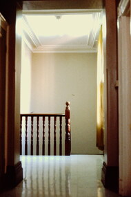
Slide - Kew Post Office, 1980
A civic campaign for new public offices developed in Kew in the 1880s. After much deliberation, the location chosen was the junction of Bulleen and Cotham Roads. The buildings were designed by George Watson and John Henry Harvey, architects within the Department of Public Works (Victoria). Building was commenced in 1887, and after one year, the buildings were opened. The Post Office was transferred to the new Commonwealth Government in 1901. The Police Station and Court House, sold by the Victorian Government to the City of Boroondara in 2007, are now a community cultural centre and performing arts venue.The buildings were listed on the Victorian Heritage Register Register (HO885) in 1991. They are historically and architecturally significant to the State of Victoria because Watson and Harvey's designs exhibit diversity in integrating civil offices, they accommodate the apex of road junctions, and they demonstrate a departure from the contemporaneously favoured High Victorian Classical to the Queen Anne style in the design of civic buildings. 35mm colour transparency of the first floor landing in the Kew Post Office at the corner of High Street and Cotham Road. The building is a significant example of the English Queen Anne Revival style. The photographs were taken by John Coghlan in May 1980 while it was still a functioning post office to support his written report: ‘The functional planning design, building materials and construction methods of the Kew Post Office.’ kew post office, khs - slides, new public offices -- kew (vic.), architectural styles -- english queen anne revival -
 Kew Historical Society Inc
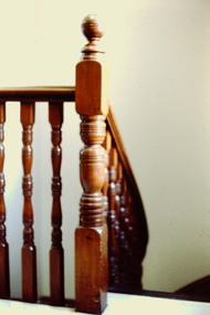
Slide - Kew Post Office, 1980
A civic campaign for new public offices developed in Kew in the 1880s. After much deliberation, the location chosen was the junction of Bulleen and Cotham Roads. The buildings were designed by George Watson and John Henry Harvey, architects within the Department of Public Works (Victoria). Building was commenced in 1887, and after one year, the buildings were opened. The Post Office was transferred to the new Commonwealth Government in 1901. The Police Station and Court House, sold by the Victorian Government to the City of Boroondara in 2007, are now a community cultural centre and performing arts venue.The buildings were listed on the Victorian Heritage Register Register (HO885) in 1991. They are historically and architecturally significant to the State of Victoria because Watson and Harvey's designs exhibit diversity in integrating civil offices, they accommodate the apex of road junctions, and they demonstrate a departure from the contemporaneously favoured High Victorian Classical to the Queen Anne style in the design of civic buildings. 35mm colour transparency of the first floor landing and staircase in the Kew Post Office at the corner of High Street and Cotham Road. The building is a significant example of the English Queen Anne Revival style. The photographs were taken by John Coghlan in May 1980 while it was still a functioning post office to support his written report: ‘The functional planning design, building materials and construction methods of the Kew Post Office.’ kew post office, khs - slides, new public offices -- kew (vic.), architectural styles -- english queen anne revival -
 Melton City Libraries
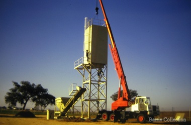
Photograph, Paramount Concrete, c.1972
Paramount Concrete Works tower on the site of Burnbank 1 – Cottage of Henri and Ann nee Dowling Myers side of road east of Myers Gully the junction of Reserve Rd. now known as Ryans Creek. Built c 1870. it remained in the family until a demolition order was placed on it in 1969 when vacated by Martha wife of Frederick 4th son of Ann and Henry. Her new house was built in McKenzie St on the south side near the corner of Smith St. Paramount Concrete established 1972, changed to Readmix Farley in 1983Paramount concrete with cranemisc. -
 Wodonga & District Historical Society Inc
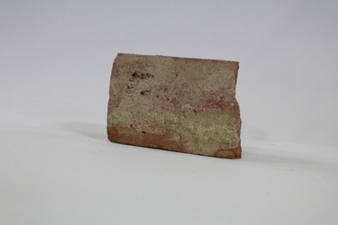
Functional object - Wodonga Station Platform Brick
The Wodonga rail line and railway station opened in November 1873 when the section of the line from Wangaratta was completed. The expansion of the railways to the northeast of Victoria occurred after the Victorian Government took over the railways in 1867 and the trains serviced large towns such as Seymour, Wangaratta and Wodonga, as well as smaller towns along the way. The original Wodonga Station, located in the middle of the city, was closed on 9 November 2008 as part of the Wodonga rail bypass project. The station platform was largely removed and the area has been redeveloped as part of the Junction precinct.This brick has local and state historical significance as the railways played a critical part in opening up the interior of Australia for commerce, transportation and settlement. It enabled Wodonga to develop as an important centre for social and commercial purposes.An old traditional brick with some joining mortar / concrete still attached. The brick formed part of the platform at the original Wodonga Railway Station prior to its demolition as part of the Wodonga bypass development.wodonga, railways, railway bypass, northeast victoria, vline -
 Wodonga & District Historical Society Inc
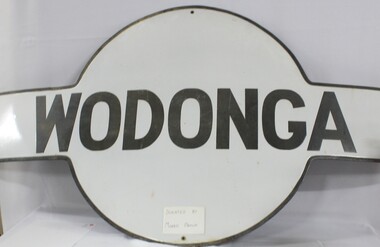
Sign - Wodonga Railway Station Sign
The Wodonga rail line and railway station opened in November 1873 when the section of the line from Wangaratta was completed. The expansion of the railways to the northeast of Victoria occurred after the Victorian Government took over the railways in 1867 and the trains serviced large towns such as Seymour, Wangaratta and Wodonga, as well as smaller towns along the way. The original Wodonga Station, located in the middle of the city, was closed on 9 November 2008 as part of the Wodonga rail bypass project. The station platform was largely removed and the area has been redeveloped as part of the Junction precinct.This sign has local and state historical significance as the railways played a critical part in opening up the interior of Australia for commerce, transportation and settlement. It enabled Wodonga to develop as an important centre for social and commercial purposes.A metal railway station platform sign, Wodonga is painted in black in the centre circle against an oblong cross piece"WODONGA"railways, wodonga railway station, victoria railways, wodonga -
 Melbourne Tram Museum
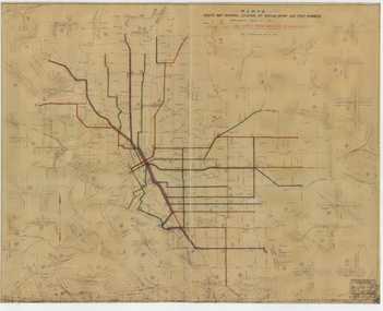
Drawing, Melbourne & Metropolitan Tramways Board (MMTB), "Route Map showing location of special work and pole numbers" "All night tram routes in colours", late 1941
Map of the system shown at two inches = 1 mile. Drawing No. P5799. Shows crossovers, track layouts at junctions, signal cabins roads, railways, and stations. Originally signed by Perway Engineer - 20/12/1940, though originally drawn in 1922. Has been marked up in colour pencil to show the all-night routes and the individual services. The plan shows the lines to Maribyrnong Munitions works along Cordite Ave and Wests Road and the track from Moonee Ponds to Union Road, opened in July 1941, but not the extension to Essendon Airport built in 1942.Demonstrates a detail drawing of Melbourne tramways, junctions and pole numbers.Drawings - dyeline cloth-backed print - titled - "Route Map showing the location of special work and pole numbers" and subtitled - "All night tram routes in colours". trams, tramways, mmtb, trackwork, tramways, junction, map, world war 2, night trams -
 Ballarat Tramway Museum
Slide - Ballarat SECV depot - trams 41 & 21- set of 5, Ron Hood, 12/1970
Set of five colour photographs by Ron Hood December 1970 at the Wendouree Parade depot: 1 - Tram 41, showing destination of Mt Pleasant waiting to cross the road - a depot worker is at the controls. 2 - side on view of tram 41- has two Johnnie Walker whiskey roof adverts. 3 - tram 21 showing Mt Pleasant arriving at the depot. Note the red signal lamp on the pole behind the tram. 4 - trams 41 and 21 changing over at the junction. 5 - front of depot with trams 40 and 37 visible. Yields information about tram operations and the process of changing trams over at the depot.Set of 5 Colour slides in hanimount cardboard mounts.Titled "Outside depot" or "Ballarat Depot" in ink.tramways, trams, depot, tram 41, tram 21, wendouree parade, tram 40, tram 37 -
 Melbourne Tram Museum
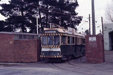
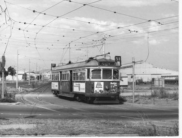
Photograph - SW6 tram 967 departing Essendon Airport, Clive Mottram, February 14 1976
967 waits at traffic lights at the junction of Vaughan St and Lancefield Rd (a non-freeway section of the Tullamarine Freeway) to cross to the tramway ROW parallel to Matthews Ave. The driver in shirt sleeves is about to lean out of his left doorway to press the traffic light activation button. The tram displays 'City 59' with run number 'E22'. All right-side windows are closed yet the sliding doors are open which is unusual for a revenue service car. It was, however, normal practice to not shut the left side doors in warmer weather.Yields information about last weeks of Essendon Airport terminusBlack and white print with note on rear.In ink on rear: "Photo by Clive Mottram. Photo taken Feb 14th '76 on Airport section soon to go. 967 is one of the Preston Trams put out to other depots now that Z class tram[sic] are operating at Preston. Other trams including W7 are at Glen Huntly and Malvern Depots. 351 Enlarge to 5 1/2" wide."sw6, tram 967, essendon, airport, vaughan st, lancefield rd, matthews ave, city, route 59, run number e22, tramway row, traffic light activation button, open sliding doors, revenue service -
 Ballarat Tramway Museum
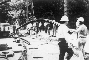
Photograph - Bromide of a b/w photograph, Nov. 1974
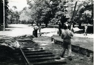
Has strong association with the event of laying the track across Wendouree Parade during Nov. 1975, an essential task to enable the re-opening of the tramway by the BTPS.Bromide of a black and white photograph of rails being laid to cross Wendouree Parade to access the new BTPS depot access track. Excavation done, first main curve rail being positioned using a crane. Date of photograph late November 1974. Depot Junction in background. BTPS Annual report states that site work began 22/11/1974. Photographer unknown. Bromide made c1994 for possible publication, but not used. See also Reg item 3506.1 and .2 for other photos on the same day. See 1974 - 1975 BTPS Annual Report page 4.trams, tramways, btps, wendouree parade, track laying, depot junction -
 Ballarat Tramway Museum
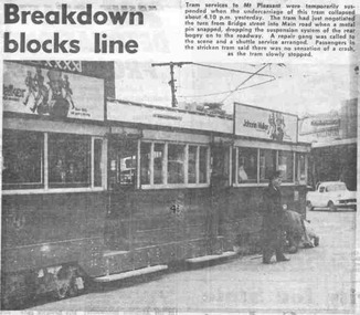
Newspaper, The Courier Ballarat, "Breakdown blocks line", 2/07/1971 12:00:00 AM
Newspaper clipping from The Courier, Ballarat, dated 2/7/1971, about the derailment of SEC Ballarat No. 41 just past the junction of Main St. and Bridge St. at about 4.10p, the previous day on the way to Mt. Pleasant. Has photo of No. 41 with the repair gang and a crew member. Note with the news item, says a pin broke and "the undercarriage of the tram collapsed". Photo has had No. 41 gone over in ink to highlight the number. One of large group of newspaper cuttings from John Bainbridge, 7/4/02. Has cutting date separate from item. accidents, main st, mt pleasant -
 Ballarat Tramway Museum
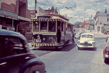
Slide - 35mm slide/s, Travis Jeffrey, 1961
Agfa plastic mount (blue base, white cover) of a photograph of No. 26 at the junction of Bridge and Victoria St. turning pole, with destination of Haddon St, with the Verna Cake shop, State Savings Bank of Victoria and Caltex Service station in the background.. Tram is in the process of being fitted with dash canopy lights and tiger strips and White Horse Whiskey advertisement on the back dash panel. Photo taken early 1961. Slide rescanned at 3200 dpi 24-10-2020, jpg replaced, tiff file retained. This file was scanned in 2003 and may show colour changes."BAS 18" in penciltramways, trams, bridge st, haddon st, victoria st, tram 26 -
 Ballarat Tramway Museum
Photograph - Black & White Photograph/s - set of 2, Nov. 1974
Has strong association with the event of laying the track across Wendouree Parade during Nov. 1975, an essential task to enable the re-opening of the tramway by the BTPS.Black and white photograph of rails being laid to cross Wendouree Parade to access the new BTPS depot access track. Excavation done. Date of photographs late November 1974. Depot Junction in background. BTPS Annual report states that site work began 22/11/1974. Has date stamp of "8.1.75" on rear of photograph. .1 - prior to first main curve rail being positioned using a crane. .2 - after first curved rail laid - see also Reg Item 1633. See also Reg Item 1633 for another photograph on the same day.tramways, trams, btps, wendouree parade, track laying, depot junction -
 Ballarat Tramway Museum
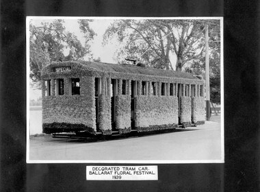
Photograph - Black and White photograph/s - mounted, State Electricity Commission of Victoria (SECV), 1939
Yields information about the tram decorated for the Ballarat Floral Festival of 1939. Original print of this photograph.Mounted photograph on black light weight card, of the Ballarat (SEC 1st) No. 29 decorated for the 1939 Floral festival. Paper flowers made by the wives of the tramway staff members. Photographed at depot junction. See also Reg. item 1369 for another photograph of the tram at the Depot. Tram showing "SPECIAL". On lower edge white label in ink "Decorated Tram Car. Ballarat Floral Festival. 1939". On rear of sheet has label "Official Switching on - Learmonth". Photo glued to sheet. See Reg Items 1363 for larger prints of these photographs for further details of this photograph.trams, tramways, secv, illuminated trams, decorated trams, floral tram, tram 29 -
 Ballarat Tramway Museum
Photograph - Colour Print/s - set of 9, Earl Ewers, 6/10/2011 12:00:00 AM
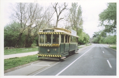
Yields information about BTM activities, AGM and repainting of No. 33.Set of nine coloured photographs taken by Earl Ewers Oct. 2011. .1 - No. 18 at St Aidans Drive - 6-10-11 .2 - ditto at Depot Junction .3 - No. 33 being prepared for repainting - Alan Snowball .4 - ditto .5 - BTM AGM - 38 at Gardens Loop 23-10-2011 with Richard Gilbert and Graeme Cleak in the view. .6 - as for .3 .7 - BTM AGM - Richard Gilbert speaking, with Peter Winspur, Greg Rodgers, Carolyn Cleak. .8 - ditto .9 - BTM AGM - 38 at Gardens Loop, with Austin Brehaut.Earl has written captions on the rear of the photograph in green ink.trams, tramways, btm, agm, repainting, tram 18, tram 33, tram 38 -
 Wodonga & District Historical Society Inc
Photograph - Mann Collection Album - Old Police Station and Courthouse, C1964
Elaine Mann was married to David Mann, a successful Wodonga businessman and community leader who passed away in Wodonga in June 2012. David was a member of the Mann family who began their business in Wodonga in 1920. Elaine was a teacher in Wodonga for many years and an active member of the community.This photo collection is of significance as it documents how the businesses and buildings in Wodonga have evolved and contributed to community throughout the late 20th century.This was Wodonga's second police station, built in 1900. It was built on High Street, next to Bond Street. The Court House can be seen in the background. The building was formerly used as a custom-house or bond store where people paid import duties on goods coming into Victoria from other states, including N.S.W. This is reflected in the street name. The Court House was destroyed by fire in 1964. This police station was in use until a move was made into a new police station in Elgin Street (next to Elgins Hotel) in December 1967. This area is now part of the newly developed Junction Place Precinct.high st wodonga, woldonga police station, wodonga court house, bond store -
 Federation University Historical Collection
Map, Ballarat Goldfield, c1898
This map shows geological features, suggests the last basalt flow, and includes alotments and names of Mining Companies. Although this map has no date on it the Ballarat Industrial School is used for dating purposed. The Ballarat Industrial School ran from 1869-1879, but the term Ballarat Industrial School Reserve was still in use in 1898 and possibly beyond.Geological Map of Ballarat with 3 holes in the left hand side. The map indicates the position of Lake Wendouree, Township of Warrenheip, Ballarat East, Industrial School Reserve, Winters Swamp, Police Paddock, Wyndholm Premptive Right (Salton and Waldie), Black Hill, Vale Park Reserve, Pennyweight Hill, Little Bendigo, Black Swamp Lead, monte Christo Reef, Chinaman's Gully, Miners Rest, Pincotts Dam, Northumberland Gully. It also show the following goldmining companies: City of Ballarat, Kohinor, Hand and Band, Great North West, Northern Junction, Kneeshaw, Rossers Freehold, Silurial.ballarat, warrenheip, lake wendouree, ballarat east, winters swamp, winter swamp, wyndholm premptive right, cemetery, vale park reserve, little bendigo, kneeshaw co., industrial school reserve, kirks dam, pincotts dam, black hill, wombat hill, dead horse gully, miners rest, mt rowan, salton and waldie, rose hill co, great north west no 1, rose's freehold co, hand and band co, police reserve, police paddock, mount rowan, ballarat industrial school reserve, market reserve, winter's swamp, kneeshar co, monte cristo line of reef, chinaman's gully or black snake, milkmaid's gully, ballarat gold field, bakery hil lead, old gravel pits lead, golden point lead, eureka lead, miner's rest, yarrowee creek, leigh creek, black swamp lead, yorkshire reef, nil desperandum reef, cockatoo lead, hit or miss gully, herbert werner frederick de nully, pennyweight hill, esmond's lead, ash's lead, nightingale lead, john bull gully, gladstone reef, whitehorse reef, petticoat creek, pincott's dam, frenchman's gully, tim's crushing plant, jenkin's gully, california gully, drake's creek, sulton and waldie, ballarat undustrial school, ballarat & mariborough railway -
 Melbourne Tram Museum
Drawing, Melbourne & Metropolitan Tramways Board (MMTB), "Plan of Tramway System - showing route mileage of electric tramways", Late 1960's
Drawings - dyeline print - titled - "Plan of Tramway System - showing route mileage of electric tramways" - Principal Junctions and intersections shown diagrammatically. Map of system shown at 40 chains to the inch. Drawing No. P6050. Shows crossovers, signal cabins, automatic points, closed cable tram lines in the city area, roads, railways and stations. Originally signed by Perway Engineer - 31-7-1951, last update March 1963. Has a list in the bottom left hand corner of abandoned cable tram lines. See Reg Item 1638 for a 1987 version and 3642 for a 1941 version.trams, tramways, mmtb, trackwork, tramways, junction, map -
 Melbourne Tram Museum
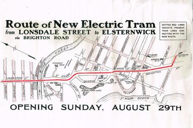
Poster, Melbourne & Metropolitan Tramways Board (MMTB), "Route of New Electric Tram from Lonsdale Street to Elsternwick via Brighton Road - Opening Sunday August 29th", Original 1926
Poster - special size, titled "Route of New Electric Tram from Lonsdale Street to Elsternwick via Brighton Road - Opening Sunday August 29th". Shows the tram rote in red and other tram lines dotted, including the Yarra River. Given its condition - a reproduction poster. From the Don Storey tram history notes - 1926 - 29 August - "he Elsternwick - St Kilda Junction line was opened, replacing the Brighton Road cable line together with an extension to Glenhuntly Road, and was built as double track." .1 - Laminated A3 version - added 30/6/2021trams, tramways, st kilda rd, brighton rd, lonsdale st, new tramway, conversion, elsternwick -
 Orbost & District Historical Society
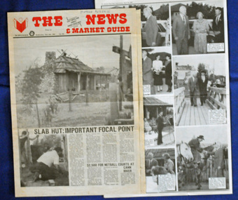
newspaper clippings, April, May 1987
The Slab Hut (Orbost Visitor Information Centre) was opened on March 28, 1987. It was officially opened by Dr D. Caughey, the governor of Victoria. The Orbost Visitor Information Centre is situated in Forest Park on Nicholson Street. The centre is housed in the historic Slab Hut. The hut was an original family dwelling built in 1872, on a site approximately three kilometres upstream from the junction of the Buchan and Snowy Rivers. The Hut was removed from its original site around 1970, and stored until 1984 when the Shire Council approved the current site. It was restored and brought to life as a Tourist Information Centre in 1987.The Slab Hut is an icon of Orbost. These newspaper articles are contemporary records of the opening of this building.A selection of articles from The News and the Snowy River Mail. All relate to the opening of the Slab Hut, the Orbost Visitor Information Centre. They are photographs, information and the history of the Slab Hut.slab-hut-orbost newspaper-snowy-river-mail -
 Glen Eira Historical Society
Letter - Woodbridge, Alan
Letter written by Alan Woodbridge, grandson of Caulfield builder J.E Morgans, dated 14/12/1992 (two sheets, handwritten, plus type writer duplicate). Woodbridge recalls that he lived at 16 Stanley Park front 1942 to 1954, attended Caulfield North Central School from 1940 to 1950, sold newspapers as a lad at Balaclava Junction, and played lacrosse for Caulfield, like his uncle Eddy Morgans before him. The letter provides a potted history of the Caulfield Lacrosse Club, taken directly from the 1950 program for the interstate lacrosse carnival held at Richmondwoodbridge alan, caulfield north central school, caulfield lacrosse club, balaclava junction, stanley parade 16, morgans eddy, jones barry -
 Moorabbin Air Museum
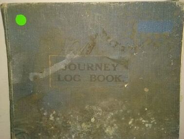
Journal (item) - Journey Log Book, DH Fox Moth VH-UQM Holyman Airways Pty Ltd
VH-UQM (Miss Currie) was the second commercial plane to operate out of Western Junction (after Miss Flinders), the first owned by the Holyman Brothers, which eventually become ANA etc. And we think it was one of the first planes destroyed in WW2, when it was lost in the hangar fire in Broken Hill just after war was declared. It was believed to have been sabotaged by Italian or German workers at Broken Hill at the time. It also was part of the early Flying Doctor service in NSW. Item currently held in Archives Australian National Aviation Museum (ANAM) September 2021 -
 Lake Bolac & District Historical Society
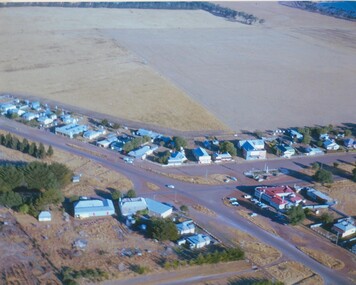
Colour photograph, Lake Bolac township. 1963
Crossroads at Lake Bolac, 1963. Junction of the Ballarat/Hamilton and Ararat/Mortlake roads. Starting centre left, the large building on the south-east side of the Ballarat road is Goodall's garage. Next door is the original Bush Nursing centre, then Dalgety's, the Bakery, the Milkbar and on the corner is the Bank of New South Wales building, Elder's, Green's drapery shop and the Lake Bolac Memorial Hall. On the traffic island in front of the Hall is the War Memorial and across the Woorndoo road is the Hotel (with the maroon roof) with stables behind. Across the road again is the Stanbury's General Store with their large warehouse behind.lake bolac, 1963, goodall, bush nursing, dalgety, elders, green, bank of new south wales, stanbury. -
 Kew Historical Society Inc
Map, Osboldstone & Co Pty Ltd, Railway and Tramway Map of Melbourne and Suburbs With Tram Timetables, 1917
The Railway and Tramway Map of Melbourne and Suburbs With Tram Timetables lists existing Cable Tram Services before the entire network was electrified. By 1917 the tramways system was divided into regions including: the Melbourne Cable Tram Service; Prahran - Malvern Electric Trams; Hawthorn Electric Trams; Melbourne, Brunswick and Coburg Electric Trams; and Brighton Beach Electric Trams. The old Outer Circle railway line is marked as ending in Deepdene, with the remainder of the line to Fairfield marked as 'Unused'. The Kew tram along High Street in 1917 ended at the Harp Junction. The Kew Spur Line is also marked on the map.The Railway and Tramway Map of Melbourne and Suburbs With Tram Timetables is historically significant as it captures at a point in time, 1917, the development of public transport infrastructure in Melbourne. As such it illustrrates the theme: Connecting Victorians by transport and communications.Printed card-covered pocket sized map that folds out with three horizontal and vertical folds. Colour map, with scale, of the rail and tram networks on one side and sixteen sections of black and white printed text and timetable information on the reverse.railway maps -- melbourne (vic.), tramways maps -- melbourne (vic.), public transport -- melbourne (vic.) -- 1910-1920, cartography -
 Ballarat Tramway Museum
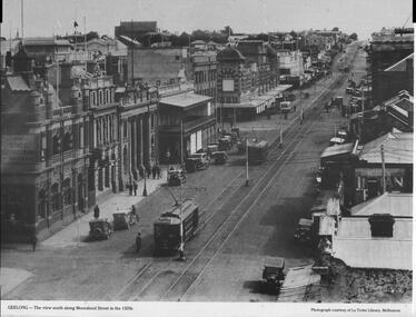
Photograph - Illustration, La Trobe Library, "Geelong - the view south along Moorabool Street", late 1920s
Photograph shows Moorabool St looking south from near Corio St Geelong. Shows the track junction with Malop St. Has Pengelley built tram 22 southbound with a Birney tram in front. The two trams are going from the Wharf to Newtown and South respectively. In the background is the State Savings Bank, The Geelong Library, Solomons store, and a building advert sign for Dr Morses Indian Root Pills. There are many motor cars, some horse-drawn vehicles, and one bus in the view. Photo, late 1920s, sourced from the La Trobe Library Melbourne.Yields information about Moorabool St Geelong late 1920s.Publish Black and white photograph with caption and source printed along bottom edge.ballarat, trams, tramways, geelong, tram 22, birney tramcars, moorabool st