Showing 11479 items matching "maps "
-
 Victorian Aboriginal Corporation for Languages
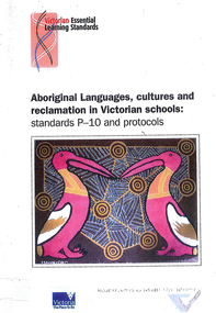
Book, Victorian Curriculum and Assessment Authority, Aboriginal languages, cultures and reclamation in Victorian schools : standards P-10 and protocols, 2009
maps, diagramseducation, language revival, bilingual education -
 Victorian Aboriginal Corporation for Languages
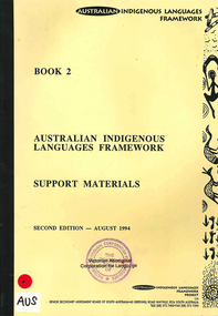
Book, Australian Indigenous Languages Framework Project, Australian Indigenous languages framework support materials, 1994
maps, tableskaurna, education, bilingual education, lote, languages other than english, language revival, aboriginal english, language ecology -
 Melbourne Tram Museum
Pamphlet, Public Transport Victoria (PTV), "Melbourne Official Visitor Map", 2012 to 2019
... Maps ...Set of 6 pamphlets - folded to DL size - full colour - each titled "Melbourne Official Visitor Map" giving location of various Melbourne attractions, transport information, ticketing, Myki, and visitor information. Has two maps - Melbourne and the inner suburbs and the CBD + Southbank area. .1 - 14 - fold - published 2012 - 13 - has standard tram and rail maps as well. .2 - 14 fold - published 2013 - 14, also has a map of Melbourne laneways. .3 - 12 fold - published 2016 - has D 3523 on front cover outside Flinders St Station. .4 - 12 fold - published 2015 - map of City Centre and Inner Melbourne, .5 - 12 fold - published 2017 - as above. .6 - 12 fold - published 2019 - as abovetrams, tramways, melbourne, ptv, maps, tramways, railways, tram 3523 -
 Bendigo Military Museum
Journal - Desert Exploration - Extract from Northern Territory Lands and Survey Dept Annual Report 1960-61, Northern Territory Lands and Survey Branch, 1961
This Extract from Northern Territory Lands and Survey Dept Annual Report 1960-61 is about Desert Exploration between Wave Hill and Tennant Creek. The 2 x fold out maps are 1:1,000,000 scale with one showing a Levelling Traverse. The exploration took place during March and April 1960. This document has been included in the RASvy collection because it was valuable information that was needed by RASvy surveyors who were required to operate in the area in later years.5 x foolscap sized pages and 2 x map foldout pages held together with a slide clip. Pages and maps are two hole punchedroyal australian survey corps, rasvy, fortuna, army survey regiment, army svy regt, asr -
 Bendigo Military Museum
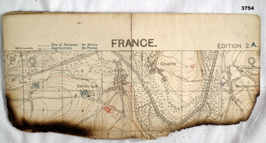
Map - TRENCH MAP, FRANCE WW1, 1918
Areas covered on this map, “Hamel, Mericourt, Proyart, Weincourt, Harbonnieres”. Item re William Alexander No 502 AIF. Refer Cat No 3746.3 for his service details.Trench map, France, Edition 2A, sheet 62D S.E, scale 1:20,000, trenches corrected to 22.4.1918, trenches in red. On outside in blue handwriting “62D S.E”map, trench, france -
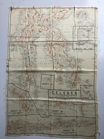 B-24 Liberator Memorial Restoration Australia Inc
Map - Australian World War II silk map of Celebes, 1940s
Silk and rayon maps were produced by Australia, Great Britain (some 1.75 million in total) and the United States (c.7.5 million) during World War II. They were issued to Allied military personnel as part of 'escape and evasion' kits.This silk map, one of relatively few produced in Australia (most Australian RAAF pilots and crew were issued with British and US maps), is an original map from World War II.An oblong, cream colour, single-sided map printed in black and white with brown contours, Celebes 'Prepared under the direction of RAAF Headquarters' Celebes (with Insets 'A' to 'E')world war ii, silk maps, australia, a185 -
 Kew Historical Society Inc
Book, Lansdowne, 100 Years Of Australians At War, 1999
400 p., [64] pages of plates : ill., maps, ports. ; 24 cm. non-fictionkorean war 1950-1953 - history, persian gulf war 1991 - history, south african war 1899-1902 - history, world war 1914-1918 - history, australia - armed forces - history, australia - history, military., world war 1939-1945 - history, wwi -
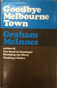 Kew Historical Society Inc
Book, Hamish Hamilton, Goodbye Melbourne Town, 1968
London, H. Hamilton, 1968 xii, 211 p. map. 23 cm. non-fictionmelbourne - history, graham mcinnes (1912-1970) -
 Kew Historical Society Inc
Book, Helen Baker, Historic Buildings: Windsor and Richmond, 1967
[Sydney], 1967 67 p. : illus., facsims., maps, plans ; 26 cm. non-fictionhistoric buildings - windsor (nsw), historic buildings - richmond (nsw) -
Kew Historical Society Inc
Book, Colin Jones, Ferries on the Yarra, 1981
Collingwood, Vic. : Greenhouse, 1981 108 pages : ill., map ; 26 cm. non-fictionferry services -- ferries -- melbourne -- yarra river, ferries -- victoria =- yarra river -- history, ferries -- victoria -- melbourne -- history. -
Whitehorse Historical Society Inc.
Document, F. S. Baker/ Yarra Hill country map, 1950s
Advertising leaflet for F. S. Baker, Mt. Pleasant Road Nunawading,Advertising leaflet for F. S. Baker, Mt. Pleasant Road Nunawading, Real Estate Agent c. 1950s, backed by Broadbent's Map no. 280, Yarra Hill CountryAdvertising leaflet for F. S. Baker, Mt. Pleasant Road Nunawading, broadbents, baker, f. s., mount pleasant road, nunawading, no. 20 -
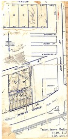 Ringwood and District Historical Society
Map, Partially trimmed copy of a retail and residential auction advertisement, Ringwood, Vic. - 1926
One of 3 unrelated land subdivision maps on cardboard backing. Numbered allotments on Nelson Street, Seymour Street and Whitehorse Road, Ringwood.W.J. Bonwick, Licensed Surveyor, Phone WU4830. Location map also includes Bourke Street, Bond Street, Charter Street, Ringwood Street, and Shops and Market sites in Ringwood. -
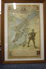 Wangaratta RSL Sub Branch
Poster - Framed Poster, C1915
Map of the Dardanelles Strait, Turkey, used as a World War I recruiting poster Includes photographs of King George V; Major-General Sir W.T. Bridges; Brigadier General G.D. Legge; General Sir Ian Hamilton; and Lieut-General Sir William Birdwood and list of Australian Commonwealth Brigade CommandersPosters were used for various government propaganda campaigns over the course of World War I, most significantly to encourage enlistment, but also to raise money for war charities, to encourage saving and frugality and to rally the home front.Timber framed poster of map of Dardanelle Peninsula featuring soldier holding rifleIn top margin: "Rally round the flag, boys!" In lower margin: "Your King and country needs you!" ww1, recruiting poster -
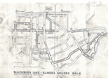 Whitehorse Historical Society Inc.
Map, Blackburn Lake - Elmore houses walk, 1/11/1991
... maps ...Map of Blackburn outlining a walk through the lake.Map of Blackburn outlining a walk through the lake. The route includes four Elmore houses.Map of Blackburn outlining a walk through the lake.maps, blackburn lake sanctuary, the avenue, blackburn, laburnum street, main street, gardenia street, blackburn road, gordon crescent -
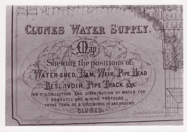 Clunes Museum
Document - MAP
CLUNES WATER SHED SUPPLY MAP SHEWING THE POSITION OF WATERSHED ECT. FOR THE COLLECTION AND DISTRIBUTION OF WATER FOR DOMESTIC AND MINING PURPOSES TO THE TOWN OF & GOLDMINES IN AND AROUND CLUNES.PHOTOCOPY SECTION OF PHOTOGRAPH AND PLAQUE AND MAP OF CLUNES WATER SUPPLY. SHOWING THE POSITION OF WATERSHED, DAM, WEIR PIPEHEAD RESERVOIR PIPE TRACK.SEE PHOTOGRAPH ON BACK OF HISTORY OF OBJECT.local history, photographs, water supply -
 Bendigo Military Museum
Map - TRENCH MAP, FRANCE WW1, 1918
Areas covered on this map, “Coisy, Allonville, Busy, Franvillers” Item re William Alexander No 502 AIF. Refer Cat No 3746.3 for his service details.Trench map, France, Edition 2A, sheet 62D N.W, scale 1:20,000, trenches corrected to 7.5.1918, British trenches in blue.On outside drawn in purple “62D N.W 1:20,000”map, france, trench -
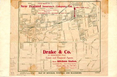 Whitehorse Historical Society Inc.
Map, Map of Mitcham, Tunstall and Blackburn, 1920 ?
... maps ...Map of Mitcham, Tunstall and Blackburn.Map of Mitcham., Tunstall and Blackburn. Overprinted 'Drake & Co.' 1 copy 1927?, 1 copy 193-?Map of Mitcham, Tunstall and Blackburn.mitcham, tunstall, nunawading, blackburn, maps, drake & co., forest hill, vermont -
 Eltham District Historical Society Inc
Map, Geoff Braithwaite, Braithwaite ma0p of Eltham circa 1920
A3 photocopy of hand drawn map of Eltham created by Geoff Braithwaite (1914-2008) of his memory of the township about 1920. It includes names of streets and property owners. Folder of information on Geoff Braithwaite Includes A3 photocopy of hand drawn map of Eltham with coloured shading of Eltham in 1920s and 1930sharry gilham collection, eltham, 1920, geoff braithwaite, map, smart family cottage, eltham cemetery, flora caroline braithwaite (nee gamble), geoffrey braithwaite -
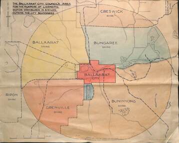 Ballarat Tramway Museum
Drawing - Map, "Licensing motor omnibuses", c1940
... maps ...The drawing or map shows the 8-mile radius that applied to the City of Ballaarat's powers for the licensing of passenger Motor buses. Shows the boundary of the City of Ballaarat, Borough of Sebastopol, Shires of Ballaarat, Bungaree, Buninyong, Creswick, Glenlyon, Grenville and Ripon. Demonstrates a plan that shows the limits of the City of Ballaarat's power to license passenger buses.Drawing - dyeline print and colouredbuses, licensing of buses, shires, maps, city of ballaarat -
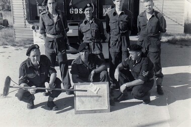 8th/13th Victorian Mounted Rifles Regimental Collection
Photograph - Hartung & section
A map board was standard equipment for every crew commander. It was a plywood base to which map was placed and covered with a sheet of plastic, all secured with bulldog clips. Chinograph pencil was used to mark map.Black and white photograph of seven 8/13 Victorian Mounted Rifles soldiers at Buna Barracks Albury. c1964. Map board control.Lance Corporal Roberts holds improvised pointer. " front: L/Cpl Roberts, Lou Madjeric, Peter Hartung, Rear: Bill Cameron, Jack Harris, John Doyle, Peter McClosky".hartung, roberts, harris, doyle, mcclusky, madjeric, cameron, vmr, buna barracks, albury, military -
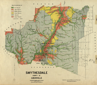 Federation University Historical Collection
Map, Smythesdale, County of Grenville, 1888, 1889
The map maker, Ferdinand M. Krause, was a professor at the Ballarat School of Mines. This land was printed form the Crown Lands Department, Melbourne. Coloured map of the County of Grenville. The edge has been taped. The scale is 40 chains to 1 inch. The map is accompanied with a foolscap sheet printed by the Mines Department in 1898. It is a Report on the Parish of Smythesdale by F.M. Krause and includes information on the water reserve, worked quartz veins, Watson's Hill, Surface Hill and Sugarloaf Hill, Haddon, Trunk Lead and the Crucible Shaft. smythesdale, krause, f.m. krause, ferdinand krause, nitingbool, watson's hill, surface hill, sugarloaf hill, haddon -
 Warrnambool and District Historical Society Inc.
Map - Map of Proposed Alterations to Warrnambool Harbour 1925, Warrnambool Harbour Committee, Warrnambool Harbour Proposed Wharves and Basin in Lake Pertobe with Eastern Wall, 1925
This map was printed in 1925 and contains the Warrnambool Harbour alterations proposed by the Warrnambool Harbour Committee incorporating the original designs of Captain Menzies, the Warrnambool Harbour Master and the City Engineer, Mr A. Lavercombe. The main features of the proposal were the extension of the Eastern Wall to almost enclose the harbour and a basin in Lake Pertobe. The design was to be placed before the Victorian Royal Commission on the Outer Ports which was established partly to examine the allegations of unsatisfactory work carried out in Warrnambool when the Breakwater was extended 300 feet in 1914 and also to make recommendations regarding all regional ports. The Warrnambool Breakwater was completed in 1890 but failed to provide the shipping conditions needed to continue Warrnambool as a viable port. Many plans and proposals for port improvement such as this one were produced in the late 19th century and the first half of the 20th century with the port officially closed in the 1940s. Still today the Breakwater and Warrnambool Harbour conditions remain a source of contention.This map is significant as it shows a 1925 design for Warrnambool Harbour hitherto little-known. It also has markings showing land sites of the time (BayView Hotel, Woollen Mill etc.)This is a map made of thick yellow paper pasted onto a cloth backing. It has two cloth tags at the top for tying up the map when folded. It appears to be a hand-drawn map copied with printed material added. The map is shaded green and red in some areas. Attached by nails to the map are wooden frames, rounded at the bottom and partly curved at the top. The map is torn and partly detached at the top. The top frame has a cord attached for hanging the map.warrnambool harbour, captain menzies, a.lavercombe city engineer, warrnambool breakwater, royal commission on outer ports -
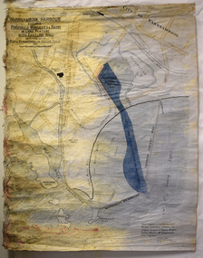
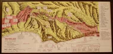 Lara RSL Sub Branch
Photograph, Gallipoli Map Anzac Battlefield 1915
This map shows where the first battalions landed at Gallipoli (April 25) Position of ANZAC battalions when the Turks attacked across the whole front and lost 10,000 dead and wounded (19 May) ANZAC evacuation (20th Dec 1915)Detailed map showing historical sights and battlefields with an information listGallipoli Map Anzac battlefield 1915,Rectangular in shape glass covered picture frame with a wooden boarder.Gallipoli 1915 Anzac Battlefieldphotograph., gallipoli., 1915, anzac, world war one, ww1, battlefield -
 Bacchus Marsh & District Historical Society
Map, Gaynor Street Area Land Sales, Maddingley, 1888
This map was produced for a major sale of land in the Maddingley area of Bacchus Marsh in 1888. The sale was conducted by two firms from Melbourne, Carney and Kelly 12 Swanston Street Melbourne. and 'Richardson, Kerr & Co. 40 Flinders Lane Melbourne. 136 blocks were for sale.A single page paper map showing land allotments for sale in the Maddingley area of Bacchus Marsh. Locations shown include Gaynor Street, Maddingley Road South, Parwan Road, Mitchem Street, Typpynge Street, Finn Street and East Maddingley Road. . The map is pasted into a bound volume containing 76 maps or plans in total. High resolution digital image stored on BMDHS computer network. bacchus marsh victoria maps, maddingley victoria maps, land use, maddingley victoria history, land sales bacchus marsh, land sales maddingley -
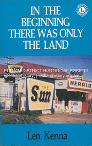 Eltham District Historical Society Inc
Book, Len Kenna, In the beginning there was only the land, 1988
A book, published as part of the Australian Bicentenary Celebrations on the history of the suburb of Bundoora. ... Includes photographs, maps and index. Local history of the outer Melbourne suburb of Bundoora, from the original Wurundjeri people through to its development as a thriving suburb in the 1980s ; section entitled "The Aborigines" (pp.14-21) discusses the traditional way of life of the Wurundjeri people prior to European settlement.bundoora, bundoora hall, hospitals, jane mckimmie, janefield, janefield church, john mckimmie, la trobe university, marvellous melbourne, mont park, mont park psychiatric hospital, plenty river, william shillinglaw, wurundjeri, yan yean reservoir -
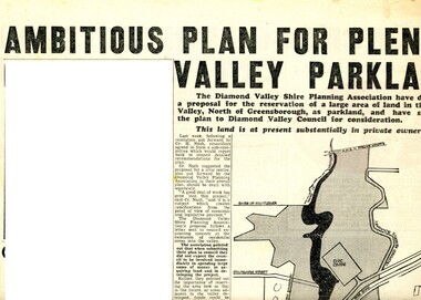 Greensborough Historical Society
Newspaper Clipping - Digital Image, Ambitious plan for Plenty Valley Parklands 1965, 05/11/1965
In 1965, the Diamond Valley Shire planning association recommended to Council that a large area of land north of Greensborough be acquired for Parkland. The idea of a Civic Centre was included with a map of the area from Grimshaw Street in the south to the MMBW pipeline reserve in the north. Includes a suggested new site for the local school, near Yando Street. This area is now part of the Plenty River Trail.An example of developments in the Greensborough area during the period of Shire of Diamond ValleyNews clipping, black and white text and map. Scanned in 3 parts.shire of diamond valley, civic drive greensborough, yando street greensborough, partingtons flat, plenty river trail -
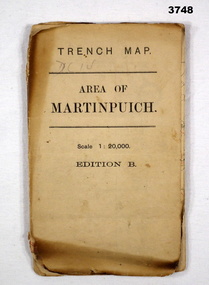 Bendigo Military Museum
Map - TRENCH MAP, FRANCE WW1, 1916
Areas covered by this map are, “Longueval, Delville Wood, Flers, Thiepval”. Item re William Alexander No 502 AIF. Refer Cat No 3746.3 for his service details.Trench map, France, Area of Martin Puch, scale 1:20,000 Edition B, trenches corrected to 24.7.1916, enemy trenches in red.map, trench, france -
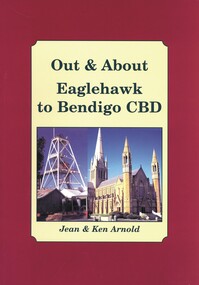 Bendigo Historical Society Inc.
Book - OUT & ABOUT EAGLEHAWK TO BENDIGO CBD, 2007
... maps ...Out & About Eaglehawk to Bendigo CBD .Plaques monuments, buildings, maps, buildings. 88 pages. Includes B&W photosJean & Ken Arnoldcottage, miners, plaques monuments, buildings, maps, buildings, bendigo and district -
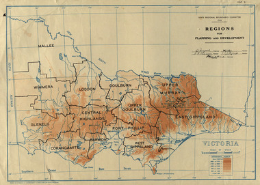 Federation University Historical Collection
Map, Victoria: Regions for Planning and Development, 1944, 1944
This map was produced for the State Regional Boundaries Committee Two colour map of Victoria showing the regions for planning and development. The regions are Central Highlands, Mallee, Wimmera, Glenelg, Corangamite, Barwon, Loddon, Goulburn, Upper Goulburn, Upper Murray, East Gippsland, West Gippsland, Port Phillip.central highlands, mallee, wimmera, glenelg, corangamite, barwon, loddon, goulburn, upper goulburn, upper murray, east gippsland, west gippsland, port phillip, victoria, m4486 -
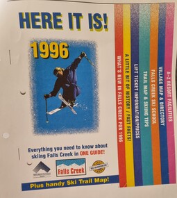 Falls Creek Historical Society
Booklet - Falls Creek Guide 1996 - HERE IT IS!
Falls Creek Resort Management produce a range of marketing materials for each season. This publication titled "HERE IT IS!" aims to include everything you need to know about skiing at Falls Creek in one guide. It also included a Ski Trail map. Sections included are:- What's new in Falls Creek for 1995 A little bit of History/fast facts Trail map and skiing tips Falls Creek Ski School Village map and directory A - Z Resort facilitiesThis item is significant because it illustrates how Falls Creek has been marketed and promoted over time.A coloured publication including images, maps and text covering all aspects of Falls Creek for the 1996 season. The cover features an image of a skier in the air. Seven sections are colour coded on the right hand edge of At bottom of page logos are included Left to right;- Alpine Resorts Commission Victoria; Falls Creek: Falls Creek Ski Guaranteefalls creek facilities, falls creek activities, falls creek marketing