Showing 15790 items matching "office"
-
 Whitehorse Historical Society Inc.
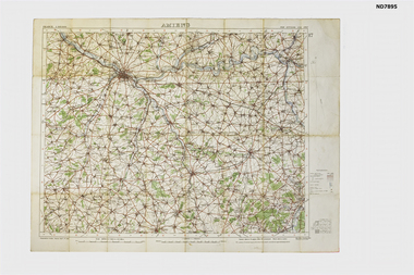
Map - Amiens France Map from collection of C H Honybun, Amiens, 1916
WW1 Topograhical Map of Amiens Region, France (Allied) 1915Printed map, France 1:100,000 Ordnance Survey, Oct 1915non-fictionWW1 Topograhical Map of Amiens Region, France (Allied) 1915world war 1914 - 1918, ameins -
 Eltham District Historical Society Inc
Audio - Audio Recording, David Taylor, Dr Andrew Lemon and Irene Kearsey - Public Records Office Victoria, 12 Aug. 2023
EDHS Newsletter No. 271 August 2023 Public Record Office Victoria (PROV) is the Archive of the State Government of Victoria. Established fifty years ago under the Public Records Act 1973, PROV at the Victorian Archives Centre in North Melbourne now holds around 106 kilometres of public records from 1836 to the present day. There are also PROV collections at Ballarat, Beechworth, Bendigo, Geelong and the University of Melbourne. Our next meeting will be about PROV and former PROV staff member Andrew Lemon, will briefly reminisce about his work there, in it’s early days. As Assistant Director Access Services at PROV, David Taylor oversees the management of, and access to, the State collection. David will be outlining PROV’s unique role in Victoria, the nature of the public records it holds and how researchers can use increasingly sophisticated online resources to discover more about their ancestors and Victorian history. Finally, our Society member Irene Kearsey will talk about her experiences as a long-time volunteer at PROV.1:21:12 duration Digital MP3 file; 27.8MBaudio recording, eltham district historical society, meeting, society meeting, eltham, david taylor, dr andrew lemon, irene kearsey, public records office victoria (prov) -
 Greensborough Historical Society
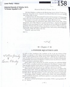
Article, A Pioneer Squatter's Life, 09/04/1837o
The Willis family were early settlers at Lower Plenty, just near where the hotel and old bridge are today. This is a chapter from Historical Records of Victoria / editor-in-chief, Michael Cannon ; [compiled by the Public Records Office]. Vol. 6. The Crown, the land, and the squatter, 1835-1840.Diary of James L Willis from 1837, portraying hardships suffered in the young colony of Victoria.24 page photocopy of chapter of a book. Digitised copy included.Handwritten inscription on front page: Willis family of Lower Plentywillis family, plenty river, yarra river, lower plenty, james willis -
 Port Melbourne Historical & Preservation Society
Document - CD-ROM, Public Records Office Victoria (PROV), Port Melbourne, Nott Street State School No 1427, 1967 - 1974
COPYRIGHT PUBLIC RECORDS OFFICE Port Melbourne - Nott Street State School No 1427 .01 - History file. DVD containing 19 pages of images of letters and documents concerning the history of Port Melbourne Nott Street State School No. 1427 from 1874 to 1974. Included are the names of the first teachers and all head teachers .02 - Centenary Souvenir. DVD containing 16 pages of images of the 1974 Centenary Souvenir booklet, including photographseducation - primary schools, celebrations fetes and exhibitions, built environment, nott street state school -
 University of Melbourne, Burnley Campus Archives
Poster - Black and white and colour prints, Information Branch Victorian Department of Agriculture, Field Machinery
Collection of photographs pasted on cardboard. (1) Students ? (2) Student on a ride-on grass cutter near Luffmann Ponds labelled, "Photograph by Information Branch Victorian Department of Agriculture Ref. No 1981 (914-43)." (3) Student on ? In Field Station. (4) Students using lawn mower and whipper snipper near Engineering Building. "VCAH" on reverse. (5) Student on ride-on grass cutter on Oak Lawn. Found in Fred Taylor's office, former mechanic. In 2015.students, grass cutter, luffmann ponds, field station, lawn mower, whipper snipper, engineering building, vcah, oak lawn -
 University of Melbourne, Burnley Campus Archives
Photograph - Black and white print, M. Nelson, T.H. Kneen, c. 1956
T.H. Kneen in his office with possibly M. Nelson . Probably donated by M. Nelson.t.h. kneen, office, maureen a. nelson (née skuse) -
 Melbourne Tram Museum
Document - Report, J. G. Membrey & Co., Melbourne and Metropolitan Tramways Board, "Leasing of former MMTB Head Office", Oct. 1940
Set of two reports regarding the difficulties of leasing the former MMTB head office building at 673 Bourke St following the move into the Little Collins Street building in 1936. .1 - Six page typed, part carbon copy, report (note the fist page has the carbon copy of another page in the report on the rear) Notes the extensive discussions with the Post Masters General Department, problems with discussions with the Board's agent, Mr. J. G. Membrey, possible sale of the building, issues within the PMG over leasing buildings, discussions with Bushell's Tea Company, lease to the RSL, then the RSSILA, through a Mr Bett, who then was in talks with the PMG to sub-lease the building, discussions with the Chairman, Mr. Cameron, which occurred. What a mess! .2 - two page carbon copy of report from Mr. J. G. Membrey to the MMTB discussion the issues with the lease, PMG, Mr. Bell and part occupied by the Radio Times. Also involves discussions with Mr. McGrath Deputy Chairmen when Mr. Bell was overseas. Report dated 19/10/1940. Two copies held.trams, tramways, mmtb, head office, bourke st, lease agreement, real estate, pmg -
 Ballarat Tramway Museum
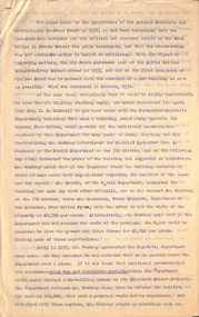
Document - Photocopy, Public Records Office of Victoria, "Summary of Capital & share of the Ballaarat Tramway Co. Ltd. (in Liquidation) up to 21st day of April 1903", c1994
Photocopy over seven pages of the summary of Capital and shares of the members of the Horse tram co. Ballaarat Tramway Co. at 21/4/1903 which was being liquidated following the takeover by ESCo. Gives details of calls on each share, amounts forfeited, details of the Directors and details of each member; Surname, Christian Name, Address, Occupation and amount of shares held. Handwritten original. Made from records held by the Public Records Office of Victoria, arranged by Alan Bradley c1990.trams, tramways, horse trams, shareholders, ballaarat tramway company, liquidation -
 Melbourne Tram Museum
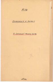
Legal record, Commonwealth of Australia - Copyright Office, "Commonwealth of Australia - Re copyright Tramway Routes", 8/12/1925 12:00:00 AM
Legal document within a light brown manila document - titled "Commonwealth of Australia - Re copyright Tramway Routes". Typed on pre-printed paper, Copyright Office, No. 14428, registering the MMTB as the copyright owner in a literary work, a map, entitled "Melbourne's Tramway Routes and Time Tables". Dated 8-12-1925, with date stamp of 22/12/1925 as being received by the Board. Address to A. S. Whyte of the Board. Folder has file number "110" written on the outside.trams, tramways, mmtb, commonwealth government, legal agreements, copyright, maps -
Federation University Historical Collection
Map - Framed image, Public Record Office Victoria, Eureka Treason Trial Map (printed copy), 1855
The persecution produced the original of this map as an exhibit for the Treason Trials of thirteen of the Eureka Stockade in Melbourne in 1855. Witnesses at the time accepted that the map showed the location of the stockade at Ballarat and the route taken by the military and police when the stockade was attacked on 03 December 1854. The original of this work is held by the Public Record Office Victoria.Printed copy of the plan used at the Eureka Treason Trials in 1855.eureka stockade, treason trial map, ballarat, lydiard street north, camp street, paroompi, yarrowee creek -
Ringwood and District Historical Society
Land titles and plan, Victorian Titles Office, Titles and plans of Ringwood Land between Mullum Land and Wonga Rd. (Re Ann Jane Kennedy). 1907, 1-Oct-07
The documents pertaining to Ann Jane Kennedy inheriting the land from her late husband Samuel John Kennedy and the history of the transfers of land from Ann Jane Kennedy in 1907 until the title was cancelled in 1925 to James Melbourne Ross. The area was 10 acres between Mullum Mullum Road and Wonga Road retrieved from Titles Office.Ten pages of photocopied titles and plans of land in Ringwood between Mullum Road and Wonga Road, also transfer of original land. -
 Bendigo Military Museum
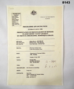
Programme - PRESENTATION OF FRENCH LEGION OF HONOUR, Office of the Prime Minister, pre 21.7.1998
This is a copy of the original produced by the Office of the Prime Minister of Australia. The presentation of the French Legion of Honour to John Henry Lockett (Jack) by the French Ambassador His Excellency Dominique Giraud was to be held in the main Hall of the Soldiers Memorial Institute Pall Mall Bendigo on 21.7.1998. (Now Bendigo Military Museum) Refer Cat No 8144 re the program on the day, Cat No 8145.10P for photographs.Program copy of original, 3 pages stapled, all print in black on yellow background. Details the presentation of the French Legion of Honour by the French Ambassador Dominique Giraud to John Henry Lockett on 21 July 1998. Covers arrivals, guests, timings, dress, speeches with the main guest being the Australian Prime Minister Mr John Howard.brsl, smirsl, french, legion of honour -
 Flagstaff Hill Maritime Museum and Village
Document - Navigation Chart, Admiralty Office, Lady Bay and Warrnambool Harbour, 03/04/1871
This Chart titled “Lady Bay and Warrnambool Harbour” was surveyed by Nav. Lieut. H.J. Stanley, of Britain's Royal Navy, in 1870 and printed in April 1871. The chart was made before the Warrnambool Breakwater was built (construction had begun in 1874 and was completed in 1890). The chart includes Directions for entering Lady Bay, Warrnambool Harbour. These are "Vessels entering Warrnambool Harbour must bring the Red Light in sight and steer in with it in line with the upper white Light bearing North, until the Green Light on the Jetty is opened, when steer towards it and anchor. The best anchorage is in 2 ¼ fms [fathoms)] of water, about a cable from ledge off Breakwater rock. Or where convenient, according to draught of water, only endeavouring to anchor as close as possible to Breakwater rock. It is not safe to enter or leave the Harbour in south westerly or Southerly gales.” This chart is significant for its strong connection to the maritime history of Warrnambool Harbour and Lady Bay, and eventually to the Warrnambool Breakwater. The Warrnambool Breakwater is registered as a place of significance on the Victorian Heritage Database (VHR H2024). A copy of the same chart was used to plan several submissions for future changes to the jetty and breakwater. The chart is a historical record of structures existing in 1870; the Warrnambool Jetties, Lady Bay, the leading lights (lighthouses), streets, roads, bridges and many buildings. It also shows the lay of the land and seabed.Canvas chart of Australia, South Coast, Victoria Title: Lady Bay and Warrnambool Harbour Surveyed by Nav. Lieut. H.J. Stanley, R.N., 1870. Magnet Variation, 1870 Published April 3, 1871, by the Admiralty, London. Directions for vessels entering Warrnambool Harbour are printed on the chart. The chart has a lacquer or seal over it.Top of chart has logo "HYDROGRAPHER OFFICE" "Price Eighteen Pence". "Engraved by Edward Weller" Along bottom of Chart: “London… Published at the Admiralty, 3rd April 1871, under the Superintendence of Rear Admiral G.H. Richards, F.R.S. Hydrographer, Corrections July 71” Bottom of chart “Australia South Coast Victoria Lady Bay and Warrnambool Harbour. 2494”flagstaff hill, warrnambool, chart of lady bay warrnambool 1870, warrnambool harbour, cartography, navigation, warrnambool breakwater, 1871, australia – south coast / victoria, lady bay, 1870, nav. lieut. h.j. stanley, r.n, directions for entering warrnambool harbour, hydrographer office, rear admiral g.h. richards, edward weller, port of warrnambool, flagstaff hill maritime museum & village, maritime museum, maritime village, shipwreck coast, map, chart, navigation chart, admiralty chart, breakwater, jetty, pier, vhr h2024 -
 Ballarat Tramway Museum
Document - Photocopy, Public Records Office of Victoria, List of shareholders of the Ballaarat Tramway Co, c1994
Photocopy over three pages of the members (shareholders) and the number of shares held in the Ballaarat Tramway Company Limited (horse trams). Date given as 2nd day of November, but no year given. Possibly 1896 following the introduction of the new Companies Act. Company Secretary was a person with the surname of Brown, possibly Edward Nathan, who is on the list of shareholders and occupation shown as Accountant. List gives Surname, Christian Name, Address, occupation and the number of shares held. Made from records held by the Public Records Office of Victoria, arranged by Alan Bradley c1990.trams, tramways, horse trams, shareholders, ballaarat tramway company, management -
 Charlton Golden Grains Museum Inc
Photograph - Lithograph, Rider & Mercer, Views of Charlton
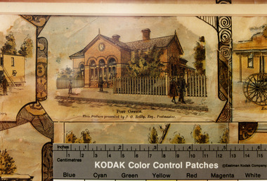
Charlton Post Office, High St, December 1891, built in 1879 to replace the original Post Office built in Camp St in 1878.Copy of Charlton Post Office High Street 1891 taken from the lithographs of Rider & Mercer. Possibly hand coloured. Brick building with three arched doorways and a clock above the central arch. Picket fence. One person standing in front of the building, a man walking past and a couple walking past a gate. Ruler showing in lower part of photo with KODAK Colour Control Patches written on it.Post Office. This picture presented by J. G. Reily, Esq., Postmastercharlton, charlton post office, business, industry, lithograph -
 Eltham District Historical Society Inc
Negative - Photograph, George W. Bell, Excavation of site for new Eltham Shire Office building, 895 Main Road, Eltham, 1964
Black and white photograph of bulldozer excavating the former Shillinglaw Cottage site for new Shire Offices. 'Shillinglaw Trees' in background. The cottage and land were purchased by the Shire of Eltham as the site for a new shire office building. The cottage was destined for demolition but members of the community concerned at losing one of the areas earliest buildings (built c.1859) initiated a fund-raising campaign to save the cottage. In 1964 the cottage was dis-assembled, all the bricks numbered and reassembled several hundred meters to the south on a site between the Gahan house and the Eltham Railway Trestle Bridge (present-day Panther Place), which became known as the Eltham Common. The new shire offices at 895 Main Road were opened in 1965. Following the Kennett Government amalgamation of local government areas in 1994, the Shire of Eltham ceased to exist, and a new Shire of Nillumbik was created 15 December 1994 from the former Eltham shire and parts of the Diamond Valley shire. The former West Riding which included parts of Montmorency, Lower Plenty and Briar Hill were ceded to the new City of Banyule. Commissioners were appointed for several years and the new Council occupied the former offices of the Shire of Diamond Valley in Greensborough. The former Eltham Shire offices remained vacant until August 1996 the Commissioners suddenly elected to have the former Shire offices demolished immediately and the site has remained vacant ever since. It was not until 1997 before the community was allowed to democratically elect new Councillors to represent them. This photo forms part of a collection of photographs gathered by the Shire of Eltham for their centenary project book,"Pioneers and Painters: 100 years of the Shire of Eltham" by Alan Marshall (1971). The collection of over 500 images is held in partnership between Eltham District Historical Society and Yarra Plenty Regional Library (Eltham Library) and is now formally known as the 'The Shire of Eltham Pioneers Photograph Collection.' It is significant in being the first community sourced collection representing the places and people of the Shire's first one hundred years.Digital image 4 x 5 inch B&W Negeltham, eltham shire office, excavation, george w. bell collection, main road, municipal offices, shillinglaw cottage, shillinglaw trees, shire of eltham pioneers photograph collection, shire offices, significant tree -
 Eltham District Historical Society Inc
Audio - Audio Recording, Audio Recording; 2018-06-13 Jim Connor and the history of the former Shire of Eltham office site, 13 Jun 2018
June Meeting (Newsletter No. 240, Jun. 2018) Prior to Shillinglaw Cottage (c1878-80) being relocated to where it is now operated as a popular cafe near the Eltham Library, it was within Josiah Holloway’s 1850s subdivision known as Little Eltham, which later became the centre of the first Eltham township. Originally a farmer’s cottage it is historically significant because it is one of the Shire’s oldest dwellings and a fine example of the work of the well-known pioneer builder George Stebbing. In 1964 the then Shire of Eltham purchased the Shillinglaw property with the intention of demolishing the cottage and constructing new Shire offices on the site. However extensive community action resulted in funds being raised to have the building saved and relocated further south to the Eltham Common, where it was joined by the Eltham Library 1994. New Shire offices opened in 1965, but following municipal restructure in 1994 these were demolished and the land sold to a developer, which precipitated a dramatic trail of community angst, threats of legal action, the sacking of a newly elected council and several unsuccessful development proposals, by subsequent councils. After all these years the vacant site there is still guarded by the three trees that were outside the front of the Shillinglaw Cottage. At our Society meeting on Wednesday 13th June 2018 Jim Connor will speak about the dramatic tale encompassing the history of the former Eltham Shire office site and the adjoining War Memorial Buildings complex, which are now being considered for sale or redevelopment by the current Nillumbik Shire Council.1:17:57 duration Digital MP3 File 27 MB audio recording, eltham district historical society, jim connor, meeting, shire of eltham office site, society meeting -
 Ballarat Heritage Services
Photograph, Clare Gervasoni, Maryborough Town Hall and Post Office, 04/05/2025
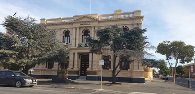
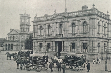
The Town Hall has architectural significance as a notable and largely intact example of a late nineteenth century provincial town hall, and as a major public building designed by the prominent Melbourne architect George Johnson. In 1887 the decision was made to build a new Town Hall on vacant land in the Civic Square near the Post Office. The architect was George Johnson, possibly the most prolific designer of municipal buildings in late nineteenth century Victoria. Tenders were called in March 1887, the successful quote being for ₤6454.5.0 by George Clayfield Senior. The foundation stone was laid in June 1887 and the new town hall opened with a grand ball in July 1888. In 1903 a memorial drinking fountain was erected in front of the building. Designed and made by George Daws, a Melbourne monumental mason, it commemorates Gerald Wilkinson, Maryborough's first war casualty, who was killed in action in 1901 during the Boer War. Films were screened at the Town Hall between 1908 and 1967. In 1939 a new entrance foyer for the hall and a Lower Town Hall were constructed, providing much needed public work during the depression. They were built by Steve Hunn for ₤5000, to plans by the Melbourne architect Harry J. Little. Funds were made available by the sale of the Borough electrical supply to the SEC. In 1971 the administrative offices at the front of the building were vacated when new administrative offices were built opposite. The old offices are now used for council and community purposes.Black and white image of a double storey town hall in Maryborough, Victoria maryborough, maryborough town hall, maryborough post office, george johnson, gerald wilkinson, harry j. little -
 Ballarat Heritage Services
Photograph, Maryborough Town Hall and Post Office
The Town Hall has architectural significance as a notable and largely intact example of a late nineteenth century provincial town hall, and as a major public building designed by the prominent Melbourne architect George Johnson. In 1887 the decision was made to build a new Town Hall on vacant land in the Civic Square near the Post Office. The architect was George Johnson, possibly the most prolific designer of municipal buildings in late nineteenth century Victoria. Tenders were called in March 1887, the successful quote being for ₤6454.5.0 by George Clayfield Senior. The foundation stone was laid in June 1887 and the new town hall opened with a grand ball in July 1888. In 1903 a memorial drinking fountain was erected in front of the building. Designed and made by George Daws, a Melbourne monumental mason, it commemorates Gerald Wilkinson, Maryborough's first war casualty, who was killed in action in 1901 during the Boer War. Films were screened at the Town Hall between 1908 and 1967. In 1939 a new entrance foyer for the hall and a Lower Town Hall were constructed, providing much needed public work during the depression. They were built by Steve Hunn for ₤5000, to plans by the Melbourne architect Harry J. Little. Funds were made available by the sale of the Borough electrical supply to the SEC. In 1971 the administrative offices at the front of the building were vacated when new administrative offices were built opposite. The old offices are now used for council and community purposes.Black and white image of a double storey town hall in Maryborough, Victoria maryborough, maryborough town hall, maryborough post office, george johnson, gerald wilkinson, harry j. little -
 Bendigo Historical Society Inc.
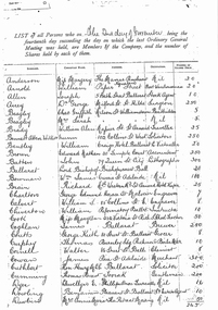
Document - LANDS OFFICE - PLANS FORWARDED TO CROWN LANDS OFFICE, 1.9.1871 to 5.4.1880
Document: hard cover journal, brown cover with darker tan spine. 239 pages. Contains index at front of journal. Listings of plans forwarded to Melbourne Crown Lands Office by Bendigo Office. Alphabetical listing in front followed by numbered pages with individual details. Parish, county, allotment, section, surveyor, date remarks.Lands Officelands office, sandhurst, bendigo, land sales, land surveyed, plans -
MYLI My Community Library
Map - Nar Nar Goon County of Mornington Map, 1944, H.E Daw - Government Printer, June 1944
This was a map made in the period before Cardinia shire was created in 1994. With intricate labelling of lot allocations, this map is a invaluable research potential for understanding the settlement of the area and its development in the first half of the 1900s. A paper map with yellow shaded areas and black ink.On Left Side: Pakenham (lot numbers throughout the map) Top side: Gembrook, Tonimbuk Right Side: Bunyip, Koo-wee-rup East Bottom Side: By Authority: / H.E. Daw Government Printer / Melbourne Koo-wee-rup Bottom Right Corner: NOTE: The allotments colored brown are freehold. In respect of which the name. The Area, and the Date where given, are the particulars set out in the Crown grant as issued by the Lands Department. / After the issue of the Crown Grant, all subsequent dealings are effected at the office of titles, Queen Street, Melbourne, and particulars as to present registered ownership, boundaries, subdivisions, etc., may be obtained by search at that office. / This plan has been compiled from the Lands Department Record as at June 1944 / Nar-Nar-Goon / County of Mornington / Drawn and reproduced at the department of lands and survey, Melbourne Price 2/. June 1944 h.e. daw, map, nar-nar-goon, county of mornington, pakenham, koo-wee-rup -
 Eltham District Historical Society Inc
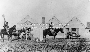
Photograph, William McLaughlin's Kangaroo Ground Hotel, General Store and Post Office, Eltham-Yarra Glen Road, Kangaroo Ground, c.1875
Initially known as the ‘Kangaroo Hotel,’ this photo shows the sign ‘Kangaroo Ground Hotel’ and William McLaughlin as the proprietor, which dates it between 1871 and 1882. The first hotel known as the Kangaroo Hotel was built at the top of the hill by Andrew Ross in 1864 commencing April; a license was obtained, and the bar opened by Edmund Pickett, the tenant, on 11th of July. The hotel was ready for public accommodation by September, 1864. On June 27, 1864, Edmund Pickett, residing at Kangaroo Ground, gave notice to the Bench of Magistrates at Eltham that it was his intention to apply on July 6th for a certificate authorising the issue of a Publican’s Licence for a house rented and occupied by himself, situated at Kangaroo Ground, containing two sitting rooms and five bedrooms exclusive of those required for the use of his family. On February 7, 1866, Edmund Pickett, publican, residing at Kangaroo Ground, applied at the Court of Petty Sessions held at Eltham for a Publican’s License for a house situated at the Kangaroo Ground, containing six bedrooms and two sitting rooms, rented and occupied by himself and licensed under the sign of the 'Kangaroo Hotel.' In 1866, with few boarders at the school and needing to reduce expenses, Ross had the bedroom house removed from the school and placed in contiguity to the hotel, the occupier to have the post office. The house was re-erected with a kitchen addition and was opened as the Post Office & General Store on April 1st. Throughout 1870 Andrew Ross found himself at odds with Pickett - he "felt much dissatisfaction at my having a hotel especially kept by a man of loose principals and low habits" and so served him notice to vacate by December 31st, occupying it himself on January 1, 1871, calling it Rossville House. William McLaughlin and his wife kept the store and post office. As a hotel was now wanted and McLaughlin was desirous to obtain a license, Ross set about making the Store building suitable which was achieved towards the end of 1871. Ross notes in his diary that the Store hotel was finished January 1, 1872. At the Court of Petty Sessions held at Eltham on 5 December 1871, William McLaughlin applied for a license for the Kangaroo Hotel, Kangaroo Ground. He had previously obtained a wine license, March 28. In June 1882, William McLaughlin of Madeline Street, Carlton, (late of Kangaroo Ground, hotelkeeper) was found insolvent due to losses in connection with the Kangaroo Ground Hotel. The license for the hotel was later transferred from Mr John Donaldson to Mrs Sophia Greenaway. It appears during McLaughlin’s tenure the hotel became known as the Kangaroo Ground Hotel. The hotel was replaced with a new wooden building in 1892, constructed by W.Holland and described as being "of a neat appearance, roomy, and fittled up with all modern requirements necessary in a business of this kind." This building was destroyed by fire in 1930. References: Ross, Andrew, 1814-1895 & Woiwod, Mick & Andrew Ross Museum. (2011). The diary of Andrew Ross 1828-1895 & the reminiscences of Andrew Ross 1851-1864 / edited, annotated and introduced by Mick Woiwod for the Andrew Ross Museum, Kangaroo Ground. Kangaroo Ground, [Vic.] : Tarcoola Press in association with the Andrew Ross Museum The Evelyn Observer, (1892, June 24). Evelyn Observer, and South and East Bourke Record (Vic. : 1882 - 1902), p. 2 (MORNING.). Retrieved May 13, 2025, from http://nla.gov.au/nla.news-article60667494 REMINISCENCES. (1893, April 21). Evelyn Observer, and South and East Bourke Record (Vic. : 1882 - 1902), p. 2 (MORNING.). Retrieved May 10, 2025, from http://nla.gov.au/nla.news-article60669116 REMINISCENCES COUNTY EVELYN. BY Andrew Ross. (No. 41) The summer of 1863-4 may be re membered by many colonists as one of the most enjoyable as regards wet weather, and it was one made remarkable by the enterprise and activity apparent throughout Evelyn County. This spirit was fostered and encouraged by the prospect presented from the opening up of the new route to the Jordan and Wood's Point, and the consequent occupation of lands and special localities along the main track. Accommodation for travellers were established at Yarra Flats, the future Healesville, Fernshaw, Marysville, while the beauties and difficulties of the Black Spur, together with the romantic region of the Stephenson Waterfalls mid the mountain forests attracted visitors other than the gold diggers. Before the end of this year 1863, the new route to Wood's Point by the Dividing Range had been so far improved that a track was laid off by the New Chum Creak, Paradise Plains, and the Springs to Emerald Hill, about half way between Jordan and Wood's Point, and the clearing of this track was looked forward to as enabling drays to be employed. The Government had so far yielded to the demands made upon it, that the work was proceeded with early in 1864. In March of that year the writer was favoured by a visit from Mr. Ligne, Surveyor-General, who was enroute to inspect the progress of the undertaking. He was accompanied by Mr. Collins Levey, his son-in-law, who had been a frequent visitor with his friend Mr. Franklin, of the Melbourne Herald newspaper, These parties, and not a few others, were glad to partake of the hospitality of residents on the Ground or, at Yarra Flats when as yet no public accommodation existed. Horsemen and pedestrians became numerous ere winter set in, and there was obviously the want of the hotel which was planned and commenced late in the autumn. The absence of any endeavour on that score by local proprietors induced the writer to undertake the erection of the Kangaroo Ground Hotel, which he did on his own responsibility. The spot best suited for the hotel being held by him on lease, he was permitted by the landlord to devote the required portion of land for the premises to be erected and occupied. Before this was accomplished the imported houses placed near the schoolhouse which had served for bedroom to boarded pupils were rebuilt near the hotel and served for a general store and post office also. Delay was experienced in procuring all the materials for the new building. After the break in the weather the roads on the Ground became very heavy and as timber had to come from town, it was under difficulties that the supply was procured. Bricks for chimneys were made in a small kiln, and hardwood for joists, &c., provided by sawyers employed for the purpose in the bush. The hotel, in consequence, was not ready for public accommodation until the spring, although a license was obtained, and the bar opened by Mr. Pickett, the tenant, on 11th of July. It may be remarked that the house was rather late in being established; a year earlier it would have secured the benefit of the rush to the new diggings, but in another sense it was rather premature for as yet no steps had been taken by the authorities to stop or even discourage the sale of liquor by unlicensed parties, and the holder of a license had to compete with the class in question. As the season (1864) advanced there were parties anxious to be the pioneers in traversing the whole of the route to Wood’s Point, but it was nigh to summer again before the track was available to vehicular traffic. I believe one of the first to effect the whole passage in this way was Mr. Gillies, some time settled at Mortlake. He drove a buggy and called at the Ground on 9th September, stating his intention to drive through to the Point, and we were subsequently informed that he had accomplished the task. (End of Reminiscences No 41)This photo forms part of a collection of photographs gathered by the Shire of Eltham for their centenary project book,"Pioneers and Painters: 100 years of the Shire of Eltham" by Alan Marshall (1971). The collection of over 500 images is held in partnership between Eltham District Historical Society and Yarra Plenty Regional Library (Eltham Library) and is now formally known as the 'The Shire of Eltham Pioneers Photograph Collection.' It is significant in being the first community sourced collection representing the places and people of the Shire's first one hundred years.Digital image (neg copy missing) Print 21 x 26.5 cmeltham-yarra glen road, kangaroo ground, kangaroo ground hotel, post office, shire of eltham pioneers photograph collection, gas lamp, hotels, kangaroo hotel, william mclaughlin, andrew ross, edmund pickett -
 Bendigo Historical Society Inc.
Document - WES HARRY COLLECTION: PROCLAMATION OF SANDHURST, 18th January 1853
Notice from the Colonial Secretary's office proclaiming that from the 18th January 1853 Castleton would be known as Sandhurst.Colonial Secretary's Officegovernment, colonial secretary's office, castleton, sandhurst, naming of bendigo -
 Eltham District Historical Society Inc
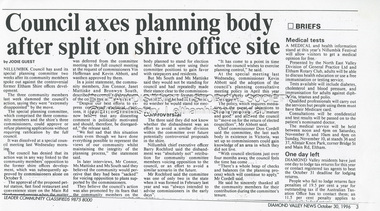
Document - News Clipping, Jodie Guest, Council axes planning body after split on shire office site, Diamond Valley News, October 30, p3, 1996
Nillumbik Commissioners used 'reserve power's to permit a controversial Shell service station and Hungry Jack's restaurant development at the former Eltham Shire Office site at 895 Main Road. More than 200 people attended the Council meeting in the public gallery and protested at the decision. 32 personal submissions were made to Council's Planning Special Committee meeting whose members vioted 3-2 against the development. The Committee consisted of the three Nillumbik Commissioners and three community members (Jim Connor, Bronwyn South and Janet Mattiske). Chief Commissioner Don Cordell, a former Shell employee excused himself from voting and the three communbity memebrs voted against the submission. The other two commissioners, Vin Heffernan and Kevin Abbott voted against it. They then immediately closed the meeting and opened a Council meeting lasting just seconds to use special reserve powers to overturn the decision. Subsequent to this the Commissioner run Council held a special meeting on Wednesday, October 23, 1996 where Commissioners Kevin Abbott and Vin Heffernan thanked all three community members of the Planning Special Committee and advised that their powers had been revoked. The article includes a joint statement from all three sacked members in which they state they have been able to bring a community perspective to the planning applications placed befopre the committee which has resulted in modifications to planning decisions. The members stated that "unfortunately, despite our best efforts to express considered apolitical opinions, it appears the Commissioners believe that any dissenting comment is politically motivated, and should therefore be disregarded." "We feel sad that this situation exists even though we have done everything possible tio represent the views of our community, whilst maintaining the integrity of the planning process."The demolition of the former Shire of Eltham offices and proposed sale and development driven by the Commissioners for Nillumbik Shire Council brought the community together in substantial protest at the infrigement of ratepayers democratic say in local government and ciommunity assets combined with protests about inappropraite development of Eltham's Gateway. This issue led to the formation of the Eltham Community Action Group which still operates strongly today (2023) on behalf of the community to ensure appropriate development within the community.895 main road, commissioners, dallas price homes, development application, eltham hub, hungry jacks, nillumbik shire council, re-zoning, shell service station, town planning, eltham gateway, eltham gateway action group, eltham shire offices, shillinglaw farm, jim connor collection, dallas howgate, nillumbik planning special committee, jim connor, bronwyn south, janet mattiske, don cordell, vin heffernan, kevin abbott -
4th/19th Prince of Wales's Light Horse Regiment Unit History Room
Data Card (3 copies), US Government Printing Office, Firing Tables for Rifle 106mm M40 firing Cartridge HEP-T M346, 1955
Data card giving the required elevation for the weapon over various ranges from 0 to 7515 yards. It also gives drift, probable error and time of flightFT106-B-2106 mm rcl, firing tables -
Koorie Heritage Trust
Booklet, Public Records Office Victoria, Finding your story : A resource manual to the records of the Stolen Generations in Victoria, 2005
"Finding Your Story" provides a comprehensive and cohesive resource of government and non-government record and archival collections in Victoria relevant to the Stolen Generations and their families.120 P; 16 sections; ports.; refs.; index; 32 cm."Finding Your Story" provides a comprehensive and cohesive resource of government and non-government record and archival collections in Victoria relevant to the Stolen Generations and their families.aboriginal australians -- victoria -- archives. | children, aboriginal australian -- government policy -- victoria -- archives. | victoria -- archival resources. -
Koorie Heritage Trust
Booklet, Public Record Office Victoria, Walata tyamateetji - a guide to government records about Aboriginal people in Victoria, 2014
This guide is designed to help researchers find records about Aboriginal people in Victoria in both the Public Reccords and Nationl Archives. It focuses on records that are specifically about Aboriginal people and issues, and inclues records created by the various government agencises overseeing the administration of Aboriginal affairs in Victoria. Public Record Office Victoria and the National Archives of Australia hold many government records about Aboriginal people in Victoria. This guide is designed to help Victorian Aboriginal people find records about their family and country. It will also assist anyone researching the history and administration of Aboriginal affairs in Victoria to find relevant records.87 pages : illustrations (some colour), maps, facsimiles ; 30 cm.This guide is designed to help researchers find records about Aboriginal people in Victoria in both the Public Reccords and Nationl Archives. It focuses on records that are specifically about Aboriginal people and issues, and inclues records created by the various government agencises overseeing the administration of Aboriginal affairs in Victoria. Public Record Office Victoria and the National Archives of Australia hold many government records about Aboriginal people in Victoria. This guide is designed to help Victorian Aboriginal people find records about their family and country. It will also assist anyone researching the history and administration of Aboriginal affairs in Victoria to find relevant records.aboriginal australians -- victoria -- history -- sources -- bibliography. | public records -- victoria -- bibliography. | aboriginal australians -- victoria -- archives. | archives -- victoria -- catalogs. | aboriginal australians -- victoria -- government relations -- history. | archives and archiving - manuscripts and records. | libraries - reference materials - bibliographies australian -
Tramways/East Melbourne RSL Sub Branch - RSL Victoria Listing id: 27511
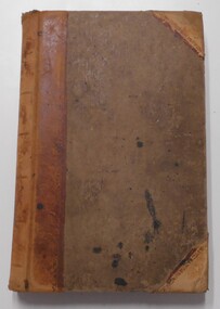
Book, THE WAR OFFICE et al, MANUAL OF MAP READING (AIR PHOTO READING AND FIELD SKETCHING Part1 MAP READING 1955), 1955
-
Tramways/East Melbourne RSL Sub Branch - RSL Victoria Listing id: 27511
Book, THE WAR OFFICE et al, MANUAL OF MAP READING (AIR PHOTO READING AND FIELD SKETCHING PART 11 1958), 1957
-
Tramways/East Melbourne RSL Sub Branch - RSL Victoria Listing id: 27511
Book, THE WAR OFFICE et al, MANUAL OF MAP READING part 111(AIR PHOTO READING AND FIELD SKETCHING PART111 FIELD SKETCHING 1957), 1958