Showing 17173 items matching "bay-bridge"
-
 Mission to Seafarers Victoria
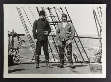
Photograph, Peckham Photographic Studios, Geo Beachcroft, Capt Dahlström and 2nd mate of the C.B. Pedersen, c. 1935
In the Sydney Morning Herald, Tuesday 27 April 1937, page 12: "The C. B. Pedersen was built in 1891. It has visited Australia several times, the most recent occasion having been in 1935, when It was anchored in Port Phillip Bay, Victoria, for several weeks, awaiting a suitable cargo. At length the master, (Captain Hjalmar Dahlström) announced that, as no cargo could be obtained he would be prepared to carry passengers in a voyage to Gothenburg, via Torres Strait. Eight persons, including three women and a small boy were accepted as passengers, and signed on as members of the crew at salaries of 1/ a month". Artist Violet Teague was one of the passengers. She painted during the voyage and exhibited her work in 1938. Built in 1891 the C.B Pedersen, a four-masted steel barque (2142 tons) was used as a training Barque. The ship foundered in April 1937, the crew was saved. Several photographs of the C.B. Pedersen taken by the same studio are held at the State Library of Victoria.see links aboveBlack and white photograph depicting two sailors in attire on the deck of a ship.verso in Black ink; Photographic studio stampcrew, c.b pedersen, captain hjalmar dahlström, violet teague, windjammer -
 Glenelg Shire Council Cultural Collection
Photograph - Photograph - Cape Grant Quarry, Portland, 03/08/1953
Port of Portland Authority Archives. From the Port of Portland website: Just 6km south of Portland, the Cape Grant Quarry is located on the eastern cliff of Cape Sir William Grant. This cape represents the core of a volcanic complex between two collapse calderas which underlie Nelson and Grant Bays to the west and east respectively. The Cape Grant quarry supplied an inexhaustible quantity of bluestone for the building of the new Portland harbour. The first stone was tipped at the root of the main breakwater on 17 November 1952. A small band of interested citizens were there to see the historic event. In the building, the breakwater was consolidated by the heavy traffic of Euclid’s and bulldozers and was further solidified by several storms that swept over it. Nowadays, blasting at the quarry is heavily regulated and carried out under the instructions of a qualified “powder monkey.” The days of seeing large explosions, along with the deep long loud BOOM are long gone with techniques of controlled blasting now improving overall environmental and safety standards.Front: Back- Purple PHT Stampport of portland archives, cape grant quarry, harbour development, construction -
 Wangaratta RSL Sub Branch
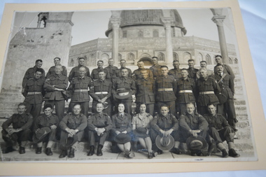
Photograph, c1942
A group of Australian soldiers photographed outside "The Dome of the Rock" shrine in Jerusalem. During the Second World War, Palestine was under a British mandate and Australian and New Zealand soldiers were back helping the British army to stop the Germans from capturing Egypt and the Suez Canal. They fought alongside several Palestinian brigades enlisted into the British Army under The Palestine Regiment. The soldier sitting second from right is Sergeant Stanley Swainson BEDFORD VX79894 2/24 Battalion. Bedford was born 30/12/1907 and enlisted at Caulfield on 18/5/1942 aged 34 years. He served in the Middle East between August 1942 and February 1942 and Milne Bay New Guinea between August 1943 and March 1944 prior to his discharge on 9/6/1945. He was the Battalion Tailor and is mentioned on page 251 of the book 2/24 - A history of the 2/24 Australian Infantry Battalion edited by R.P. Serle. World famous "Dome of the Rock", site of the ancient temple of Solomon and now a Muslim shrine. During the 7th century it served as a testament to the power of the new faith of Islam. The Dome of the Rock is one of the earliest surviving buildings from the Islamic world. This remarkable building is not a mosque, as is commonly assumed and scholars still debate its original function and meaning. With the exception of the two uniformed females, presumably nurses, one soldier if not all identified as serving with the 2/24th Battalion known as Wangaratta's Own.Original black and white photograph of soldiers standing in two rows and a row of soldiers and two females in uniform seated on step with ancient building in background.dome of rock, jerusalem, stanley swainson bedford -
 Uniting Church Archives - Synod of Victoria
Photograph, Undated c.1864
Mrs Elizabeth Draper (1808 - 1866). Second wife of the Rev. Daniel James Draper (1810 - 1866). Born Wickham, Hampshire 28 August 1810. In 1830 joined the Methodist Society at Fareham and became a local preacher. Nominated in March 1834 as a candidate for the Wesleyan Methodist ministry. Appointed preacher on probation to the Charteris circuit. Married Sarah Webb in September 1835, ordained 7 October 1835, sailed for Australia on 13 October 1835. Served at Parramatta, where his wife died on 16 February 1838. Married Elizabeth Shelley (1808 - 1866), daughter of William Shelley, formerly a missionary in Tonga and Tahiti in July 1939. Served in N.S.W., Victoria and South Australia. Elected President of the 1859 Conference. Granted leave in 1865 to return to England as the Australian representative to the British Conference. He was returning to Australia on the SS London in January 1866 when he and his wife, along with 244 others, perished when their ship sank during a fierce storm in the Bay of Biscay.Sepia toned, carte de visite studio portrait of Mrs Elizabeth Draper, seated at a table.daniel james draper, sarah webb, elizabeth shelley, ss london, bay of biscay, methodist, wesleyan, minister, president of conference, shipwreck -
 Bayside Gallery - Bayside City Council Art & Heritage Collection
Painting - oil on linen, Stieg Persson, Duck and quail eggs, Italian herbs, 2015
With a career spanning over 30 years as a painter, Stieg Persson is a well known figure within the Australian and international art world. Persson’s work is celebrated for his distinct (yet eclectic) style, which consists of elements associated with abstraction, figuration and decorative art, as well as the artist’s deeply intellectual interrogation of Australian culture and society. In this work titled, Duck and quail eggs, Italian herbs, Persson reflects on contemporary parallels in changes of taste and the desire for decadence as a political and social drive. Inspired by Brighton’s iconic Church and Bay Streets, the artist addresses the social currency of luxury and high-end cuisine by depicting rococo style blackboards which offer the latest in fine dining, alcohol, exercise classes, skin treatments and lavish linens. Persson is presenting a subtle critique of the contemporary obsession with food; as contemporary society places greater significance on the connoisseurship of eating, it does so in lieu of engagement with culture as it is traditionally conceived (music, theatre, literature and art).oil on linenstieg persson, brighton, signage, graffiti, food, chalkboard, bayside, painting -
 Queenscliffe Maritime Museum
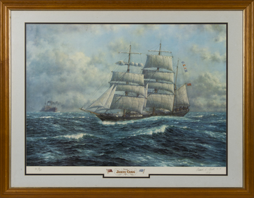
Print - Reproduction print, framed, Oswald L Brett, Barque James Craig 1874, 1974
Built in 1874 in Sunderland England she was employed carrying cargo around the world and rounded Cape Horn 23 times in 26 years. In 1900 she was acquired by Mr J J Craig, renamed James Craig in 1905 and began to operate between New Zealand and Australia until 1911. Unable to compete with freight cargo, in later years James Craig was used as a collier and later laid up, then used as a hulk, until eventually being abandoned at Recherche Bay in Tasmania. In 1932 she was sunk by fishermen who blasted a 3-metre hole in her stern. Restoration of James Craig began in 1972, when volunteers (now the Sydney Heritage Fleet) refloated her and towed her to Hobart for initial repairs. Brought back to Sydney under tow in 1981, her hull was placed on a submersible pontoon to allow work on the hull restoration to proceed. Over twenty-five years, the vessel was restored and relaunched in 1997. In 2001 restoration work was completed and she continues to go to sea.Mr Robeert Greenway A framed reproduction of a painting by Oswald L Brett on canvas paper of the Barque James Craig 1874 Barque James Craig 1874. Images of two flags; a red ensign and a ships flag 'Craig'; Oswald L Brett N.Y. 1978 james craig, windjammers, barque -
 Federation University Art Collection
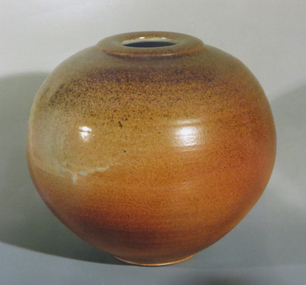
Ceramic - vessel, Woodfired Bulbous Pot by Greg Crowe, c1986
Greg CROWE (1953- ) Born England, arrived Australia 1963 Greg Crowe's intial training was in architecture. In 1980 Greg Crowe established the Hovea Pottery in the hills east of Perth and am constantly firing up new work there 30 years on.In 2008 Greg Crowe undertook a McKnight Residency for Ceramic Artists at the Northern Clay Center, Minnesota, U.S.A., and has demonstrated and exhibited elsewhere in the U.S.A. and Canada, Japan, France, Denmark, Ireland and Singapore. In 1985 he built a wood-fired salt kiln at Hovea with Fergus Stewart, and has specialised in wood-firing and salt-glazing since then, In 1992 he worked with wood firer Sven Bayer in Devon, UK. In 1996-1998 he built an anagama kiln in the south-west of Western Australia. y Texture and the unique, plastic responsive nature of claygre to stretching has been of great interest to Greg Crowe. Greg Crow signs his work with an impressed 'GC'. Thrown bulbous woodfired pot.greg crowe, ceramics, gippsland campus, jan feder memorial ceramics collection, hovea pottery, woodfire 86 -
 Melbourne Legacy
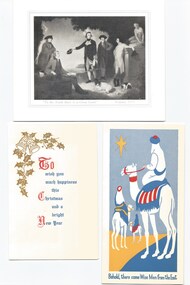
Card - Document, Order your Christmas Cards from Legacy 1961, 1961
Legacy raised funds from the sale of Christmas cards for many years. In 1961 the cards were: Captain Sturt's voyage down the Murray, 1829, by William Rowell (price was for up to 25 at 2/- each, 26 to 50 1/9 each, 51 to 200 1/6 each.) The Return from Egypt, by Judith Perrey (1/3 each) Happy Landing (1/3 each) The Wise Men (10d each) The Landing of Captain Cook at Botany Bay, by Phillips Fox (1/- each) Swanston St, Melbourne 1961, by Henry Burn (1/3 each) Yuletide Visit (1/- each) To the South there is a Great Land by Zoffany, 1771 (6d. each) Christmas Joybells (9d. each) The Star of Bethlehem (woodcut) by Ruth Barker (1/-) The subject of some of the cards might seem dated, especially those featuring the colonisation of Australia by the British. The order form and cards were part of a scrapbook of Legacy material, mostly promotional material, from the 1960s to 1990s.An example of fundraising material issued by Legacy in 1961.Order form for Legacy Christmas Cards in 1961 and a sample copy of cards.fundraising, christmas cards -
 Melbourne Tram Museum
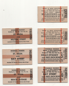
Ephemera - Weekly Tickets - rail and bus St Kilda Bus lines - set of 7, Victorian Railways (VR), 1960s
Following the complete closure of the St Kilda - Brighton Electric street railway (tramway) in 1959, the Brighton St Kilda Bus lines operated a service under a contract with the Victorian Railways with a joint ticketting arrangement. These tickets are weekly tickets for various locations along the former tramway. Those tickets available for Melbourne have the conditions of travel on the rear. The two vertical stripes indicated that the ticket was available to pass through the gates at Flinders St or Spencer St, while the large cross indicated to a ticket checker that the ticket was not available beyond St Kilda station or to pass through a set of gates. All printed on a off white card. All undated. 1 - Melbourne & Inkerman St - No. 0754 - Male 2 - Melbourne and Dickens St - No. 0620 - Male 3 - Head St and Melbourne - No. 25592 4 - Bay St and Melbourne - No. 0132 5 - St Kilda and Milton St - No. 1395 6 - St Kilda and Bawy St - No. 0190 7 - St Kilda and Beach Ave - No. 0489Demonstrates a railway ticketting system that was used on buses and railwaysSet of 7 Edmondson style railway tickets printed as Weekly tickets.railways, tickets, weekly tickets, st kilda brighton electric tramway, buses, brighton - st kilda bus lines -
 Eltham District Historical Society Inc
Photograph - Digital Photograph, Alan King, Alistair Knox Park, Eltham, 2008
Alistair Knox Park, an oasis of peace and beauty. Covered under National Trust of Australia (Victoria) Landscape Significance and Heritage Overlay, Nillumbik Planning Scheme. Published: Nillumbik Now and Then / Marguerite Marshall 2008; photographs Alan King with Marguerite Marshall.; p173 It is hard to imagine that the Alistair Knox Park, an oasis of peace and beauty beside busy Main Road, Eltham, was once the township’s rubbish dump. It was only in the 1970s that the tip was transformed into this beautiful six hectare space, which later earned it a National Trust Landscape classification. Before its life as a dump, the area was used for small farms. Thanks largely to the foresight and efforts of local environmental builder Alistair Knox, the park was designed sympathetically with the character of the wider Eltham landscape. Then, appropriately, the park was named after Knox, who was an Eltham Shire Councillor from 1971 to 1975 and Shire President in 1975. The park designers were four major forces in the urban bush landscape garden –Knox, landscape designer Gordon Ford, artist Peter Glass and landscaper Ivan Stranger. The National Trust citation for the park, originally called Eltham Town Park, includes the Eltham railway trestle bridge and the Shillinglaw Cottage. The citation states ‘the semi-natural setting of the parkland provides a landscape which is evocative of the history of the area’. Manna Gums (Eucalyptus viminalis) and Candlebarks (Eucalyptus rubida) are significant features. Most of the park’s construction was directed by Bob Grant, Superintendent of the Parks and Gardens Department for the Eltham Shire Council. First plantings occurred in Arbour Week in 1973, then the lake and botanic area were completed in 1975, with Federal Government funding, and the toilet block in 1978. Bounded by the Eltham railway line, Panther Place, Main Road, Bridge and Susan Streets, the park is in a valley about a kilometre wide overlooked by steep hills at the east and west. The Diamond Creek flows through it and the picturesque historic timber trestle railway bridge edges the north. Informal plantings of Australian indigenous and native species in open and undulating grassed settings blend with the natural landscape of the Diamond Creek to the west. The bush-style plants, particularly around the creek, balance with open lawns, paths and a cascade flowing from a small lake to another below. A footbridge over the creek leads to the park’s west. The park includes an adventure playground and barbecue areas. The park stands on part of the land bought from the Crown in 1851 by Josiah Holloway, who subdivided it into allotments and which he called Little Eltham. Most of the land was subdivided into residential lots, but the creek valley, on which the park stands, was subdivided into farm-size lots, used mainly for orchards and grazing. One of the earliest owners was John Hicks Petty, who in 1874 bought a plot from Holloway. Other families who owned properties in that area, included Rees, Clark, Waterfall, Graham, Hill and Morant. In 1901 the railway was built through the area. Jock Read, an Eltham resident since around 1920, remembers several farms in the 1920s and ’30s that occupied the site of today’s park. A poultry farm, which extended from present day Panther Place, was owned by the Gahan family. Next to that farm was another for grazing cattle owned by Jack Carrucan. Beside this was land owned by John Lyon. A doctor lived beside this, and at the north-west corner of Bridge Street and Main Road stood a memorial to the soldiers who died in World War One, which was later moved to the RSL site. Mr Read also remembers other farms and orchards west of the creek In the early 1960s the Eltham Council began buying these farms and in the late 1960s turned the areas east of the Diamond Creek into a garbage tip. When this was filled above the creek’s flood plain, the tip was moved to the west of the creek.This collection of almost 130 photos about places and people within the Shire of Nillumbik, an urban and rural municipality in Melbourne's north, contributes to an understanding of the history of the Shire. Published in 2008 immediately prior to the Black Saturday bushfires of February 7, 2009, it documents sites that were impacted, and in some cases destroyed by the fires. It includes photographs taken especially for the publication, creating a unique time capsule representing the Shire in the early 21st century. It remains the most recent comprehenesive publication devoted to the Shire's history connecting local residents to the past. nillumbik now and then (marshall-king) collection, alistair knox park, eltham -
 Orbost & District Historical Society
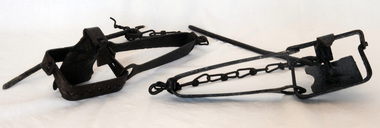
rabbit traps, First half 20th century
During the Great Depression from 1929 to 1932, rabbit trapping was a means of survival for many people. Rabbits provided meat and pelts which were sold for making felt hats such as the Akubra. Rabbit populations are controlled in the 21st century by poisoning, destroying or 'ripping' burrows (warrens), biological control with rabbit haemorrhagic disease and myxomatosis, and by shooting. Rabbit-proof fences also prevent the spread of rabbits into some areas. (ref. Powerhouse Museum) Steel-jawed rabbit traps were widely used in urban and rural Australia from 1880 to 1980. This trap is symbolic of the battle that Australians have waged against burgeoning rabbit populations for over a century. Rabbits cause enormous damage to Australian soils and biodiversity. The introduction of rabbits to this country was an environmental disaster.Two iron rabbit traps. Each consists of a pair of jaws held closed by spring tension and a triggering mechanism. When the trap is triggered the jaws close over the top of the bridge, plate and tongue mechanism that is designed to trigger the trap. A chain is attached by a hook on the bent end of the trap's spring with a long steel spike looped over the last link of the other end of the chain. The trap is designed so that the metal jaws snap shut against each other when the trap is activated by the application of weight to the pressure plate. In use, traps are set with open jaws, buried lightly just below the surface of the earth. When an animal steps on the pressure plate, the jagged teeth of the jaws snap around the animal's leg, usually breaking bone and sinew. Thus the animal is immobilised.rabbits rural trapping -
 Orbost & District Historical Society
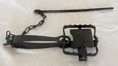
rabbit trap, first half 20th century
During the Great Depression from 1929 to 1932, rabbit trapping was a means of survival for many people. Rabbits provided meat and pelts which were sold for making felt hats such as the Akubra. Rabbit populations are controlled in the 21st century by poisoning, destroying or 'ripping' burrows (warrens), biological control with rabbit haemorrhagic disease and myxomatosis, and by shooting. Rabbit-proof fences also prevent the spread of rabbits into some areas. (ref. Powerhouse Museum) This trap was used in the Orbost district. Steel-jawed rabbit traps were widely used in urban and rural Australia from 1880 to 1980. This trap is symbolic of the battle that Australians have waged against burgeoning rabbit populations for over a century. Rabbits cause enormous damage to Australian soils and biodiversity. The introduction of rabbits to this country was an environmental disaster.A rusted iron rabbit trap which consists of a pair of jaws held closed by spring tension and a triggering mechanism. When the trap is triggered the jaws close over the top of the bridge, plate and tongue mechanism that is designed to trigger the trap. A chain is attached by a hook on the bent end of the trap's spring with a long steel spike looped over the last link of the other end of the chain. The trap is designed so that the metal jaws snap shut against each other when the trap is activated by the application of weight to the pressure plate. In use, traps are set with open jaws, buried lightly just below the surface of the earth. When an animal steps on the pressure plate, the jagged teeth of the jaws snap around the animal's leg, usually breaking bone and sinew. Thus the animal is immobilised. rabbit-trap rural -
 Flagstaff Hill Maritime Museum and Village
Document - Map, Department of Lands & Survey, Victoria / Panmure, 1942
This Emergency Edition of the map of Panmure, Victoria, is part of the W.R. Angus Collection. It was printed in 1942 during World War II. It is one of two maps donated to Flagstaff Hill Maritime Village by the family of Doctor William Roy Angus, who served as Surgeon Captain in the Australian Defence Department. The map was compiled for the Dept. of Army by the Dept. of Lands and Survey in Melbourne, prepared by the Australian Section of the Imperial General Staff, which was a British Government body created in 1907 to co-ordinate the defence of Britain and its Empire. It was printed by A.H.Q. Cartographic Company, Survey Corps, which was formed in 1941. The Corp changed its name to L.H.Q. Cartographic Company of Bendigo. In 1947 the name reverted back to the A.H.Q. Cartographic Company until 1955 when it became the A.H.Q. Survey Regiment. The W.R. Angus Collection includes historical medical equipment, surgical instruments and material once belonging to Dr Edward Ryan and Dr Thomas Francis Ryan, (both of Nhill, Victoria) as well as Dr Angus’ own belongings. The Collection’s history spans the medical practices of the two Doctors Ryan, from 1885-1926 plus that of Dr Angus who began practice in 1924. Dr. Angus served with the Australian Department of Defence as a Surgeon Captain during the Second World Was from 1942 to 1945. He served in Ballarat, Victoria, and in Bonegilla, N.S.W. until he suffering from a heart attack just before the war ended. ABOUT THE “W.R.ANGUS COLLECTION” - Doctor William Roy Angus M.B., B.S., Adel., 1923, F.R.C.S. Edin.,1928, was generally known as Dr Roy Angus. His working life included a position as a doctor with the Flying Doctor Service in Australia’s rural and remote areas. After many varied experiences Dr Angus and his family moved to Warrnambool in 1939 where he purchased “Birchwood,” the 1852 home and medical practice of Dr John Hunter Henderson. He was appointed on a part-time basis as Port Medical Officer in Warrnambool and held this position until the 1940’s when the government no longer required the service of a Port Medical Officer. Dr Angus was a surgeon at the Warrnambool Base Hospital 1939-1942. After further studies he commenced practice as an ophthalmologist in Warrnambool, pioneering in artificial eye improvements. He was Honorary Consultant Ophthalmologist to Warrnambool Base Hospital for 31 years and made monthly visits to Portland to perform eye surgery. Dr Angus and his wife Gladys were very involved in Warrnambool’s community with a strong interest in civic affairs. They were both involved in the creation of Flagstaff Hill Maritime Village, including the layout of the gardens. After his death on 28th March 1970 his family requested his practitioner’s plate, medical instruments and some personal belongings be displayed in the Port Medical Office surgery at Flagstaff Hill Maritime Village, and be called the “W. R. Angus Collection”. This Emergency Edition of the Map of Panmure is significant as an example of the documents prepared for the defence of Australia in World War 2. The Map is also significant for its connection between the Australian Army and the involvement of Dr WR Angus as a Surgeon in the Medical Services during World War II. The W.R. Angus Collection is significant for still being located at the site it is connected with, Doctor Angus being the last Port Medical Officer in Warrnambool. The collection of medical instruments and other equipment is culturally significant, being an historical example of medicine, administration, household equipment and clothing from late 19th to mid-20th century. Dr Angus assisted Dr Tom Ryan, a pioneer in the use of X-rays and in ocular surgery. The collection includes Dr Angus’s Army objects and is significant as an example of items issued to Doctors and Surgeons in the Medical Services of the Australian Army in World War IIMilitary map of Panmure, Victoria, Australia; part of the W.R. Angus Collection. Rectangular coloured map on cream paper for the Australian Army. Details include sea, waterways and land, contour lines, grid lines, names of districts, towns and roads, bridges, swamps, rail lines, cuttings, tracks, buildings (including blacksmiths), pumps, lighthouses, telegraph, telephones and electric transmission lines, and fire stations. The map has margin notes that include distances in miles to nearby towns. The map was compiled for the Dept. of Army by the Dept. of Lands and Survey in Melbourne, prepared by the Australian Section, Imperial General Staff and printed by A.H.Q. Cartographic Company, Melbourne in 1942. Crown Copyright Reserved. Inscriptions in red print state that it is and Emergency Edition and an Official document. An oval purple stamp includes the price.Printed in black; 'Victoria / Panmure", "No. 930 / Zone 6" Printed in red; “EMERGENCY EDITION”, “THIS MAP IS AN OFFICIAL DOCUMENT. IF FOUND, IT MUST BE HANDED / IN TO THE NEAREST MILITARY HEADQUARTERS OR POLICE STATION” Stamped: within concentric ovals (“- - - FOR SALE / PRICE 2/- / - - - - - OF THE ARMY”)flagstaff hill, warrnambool, flagstaff hill maritime museum, maritime museum, shipwreck coast, flagstaff hill maritime village, great ocean road, dr w r angus, dr ryan, warrnambool base hospital, flying doctor, surgeon captain, australian department of defence, royal australian army, world war 2, map panmure 1942, roy angus, port medical officer, nhill base hospital, military map, emergency map, military service australian army, department of army, department of lands and survey, a.h.q. cartographic company melbourne, panmure 1942, australian section, imperial general staff -
 Flagstaff Hill Maritime Museum and Village
Document - Map, Department of Lands & Survey, Victoria / Port Campbell, 1942
This Emergency Edition of the map of Port Campbell, Victoria, is part of the W.R. Angus Collection. It was printed in 1942 during World War II. It is one of two maps donated to Flagstaff Hill Maritime Village by the family of Doctor William Roy Angus, who served as Surgeon Captain in the Australian Defence Department. The map was compiled for the Dept. of Army by the Dept. of Lands and Survey in Melbourne, prepared by the Australian Section of the Imperial General Staff, which was a British Government body created in 1907 to co-ordinate the defence of Britain and its Empire. It was printed by A.H.Q. Cartographic Company, Survey Corps, which was formed in 1941. The Corp changed its name to L.H.Q. Cartographic Company of Bendigo. In 1947 the name reverted back to the A.H.Q. Cartographic Company until 1955 when it became the A.H.Q. Survey Regiment. The W.R. Angus Collection includes historical medical equipment, surgical instruments and material once belonging to Dr Edward Ryan and Dr Thomas Francis Ryan, (both of Nhill, Victoria) as well as Dr Angus’ own belongings. The Collection’s history spans the medical practices of the two Doctors Ryan, from 1885-1926 plus that of Dr Angus who began practice in 1924. Dr Angus served with the Australian Department of Defence as a Surgeon Captain during the Second World Was from 1942 to 1945. He served in Ballarat, Victoria, and in Bonegilla, N.S.W. until he suffering from a heart attack just before the war ended. ABOUT THE “W.R.ANGUS COLLECTION” - Doctor William Roy Angus M.B., B.S., Adel., 1923, F.R.C.S. Edin.,1928, was generally known as Dr Roy Angus. His working life included a position as a doctor with the Flying Doctor Service in Australia’s rural and remote areas. After many varied experiences Dr Angus and his family moved to Warrnambool in 1939 where he purchased “Birchwood,” the 1852 home and medical practice of Dr John Hunter Henderson. He was appointed on a part-time basis as Port Medical Officer in Warrnambool and held this position until the 1940’s when the government no longer required the service of a Port Medical Officer. Dr Angus was a surgeon at the Warrnambool Base Hospital 1939-1942. After further studies he commenced practice as an ophthalmologist in Warrnambool, pioneering in artificial eye improvements. He was Honorary Consultant Ophthalmologist to Warrnambool Base Hospital for 31 years and made monthly visits to Portland to perform eye surgery. Dr Angus and his wife Gladys were very involved in Warrnambool’s community with a strong interest in civic affairs. They were both involved in the creation of Flagstaff Hill Maritime Village, including the layout of the gardens. After his death on 28th March 1970 his family requested his practitioner’s plate, medical instruments and some personal belongings be displayed in the Port Medical Office surgery at Flagstaff Hill Maritime Village, and be called the “W. R. Angus Collection”. This Emergency Edition of the Map of Port Campbell is significant as an example of the documents prepared for the defence of Australia in World War 2. The Map is also significant for its connection between the Australian Army and the involvement of Dr WR Angus as a Surgeon in the Medical Services during World War II. The W.R. Angus Collection is significant for still being located at the site it is connected with, Doctor Angus being the last Port Medical Officer in Warrnambool. The collection of medical instruments and other equipment is culturally significant, being an historical example of medicine, administration, household equipment and clothing from late 19th to mid-20th century. Dr Angus assisted Dr Tom Ryan, a pioneer in the use of X-rays and in ocular surgery. The collection includes Dr Angus’s Army objects and is significant as an example of items issued to Doctors and Surgeons in the Medical Services of the Australian Army in World War IIMilitary map of Port Campbell, Victoria, Australia; part of the W.R. Angus Collection. Rectangular coloured map on cream paper for the Australian Army. Details include sea, waterways and land, contour lines, grid lines, names of districts, towns and roads, bridges, swamps, rail lines, cuttings, tracks, buildings (including blacksmiths), pumps, lighthouses, telegraph, telephones and electric transmission lines, and fire stations. The map has margin notes that include distances in miles to nearby towns. The map was compiled for the Dept. of Army by the Dept. of Lands and Survey in Melbourne, prepared by the Australian Section, Imperial General Staff and printed by A.H.Q. Cartographic Company, Melbourne in 1942. Crown Copyright Reserved. Inscriptions in red print state that it is and Emergency Edition and an Official document. An oval purple stamp includes the price.Printed in black; 'Victoria / Port Campbell", "No. 932 / Zone 6" Printed in red; “EMERGENCY EDITION”, “THIS MAP IS AN OFFICIAL DOCUMENT. IF FOUND, IT MUST BE HANDED / IN TO THE NEAREST MILITARY HEADQUARTERS OR POLICE STATION” Stamped: within concentric ovals (“- - - FOR SALE / PRICE 2/- / - - - - - OF THE ARMY”)flagstaff hill, warrnambool, flagstaff hill maritime museum, maritime museum, shipwreck coast, flagstaff hill maritime village, great ocean road, dr w r angus, dr ryan, warrnambool base hospital, nhill base hospital, flying doctor, surgeon captain, map port campbell 1942, roy angus, port medical officer, military map, emergency map, australian department of defence, royal australian army, military service australian army, department of army, department of lands and survey, world war 2, a.h.q. cartographic company melbourne, australian section, imperial general staff, port campbell 1942 -
 Federation University Historical Collection
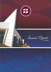
Book, University of Ballarat Annual Report, 2009, 2009
Soft covered book with a building and details from an Aboriginal dot painting on the cover. Contents include: Univesity of Ballarat Charter, About the University, TravelSmart Program, Prospects Restaurant judged Best Training Restaurant in Victoria, IMB Services Centre opening, 'Learn to Succeed' branding, grant Street Foot Bridge,Manufacturing Technology Training Centre, riding for the Disabled, Equine Centre Images include: Grant Paulson, Robert H.T. Smith, David Battersby, Christine Nixon, Angela Carey, Andrew Allen, John Brumby, Jacinta Allan, Mathew Hall, Rowan Waina, Ronnie Smith, Alsion Nguyen, Grant Hackett, Frank Stagnitti, Sam Kameer, Rowena Coutts, Barbara Webb, Trevor Ferguson, Peter Gell, University of Ballarat Council .3) Financial Statementsuniversity of ballarat, battersby, webb, coutts, gell, annual report, david battersby, barabara webb, reconciliation action plan, grant paulson, robert h.t. smith, honorary doctorate - christine nixon, angela carey, andrew allen, geoff howard, dale boucher, frank stagnitti, rowena coutts, sovereign hill, jacinta allan -
 Federation University Historical Collection
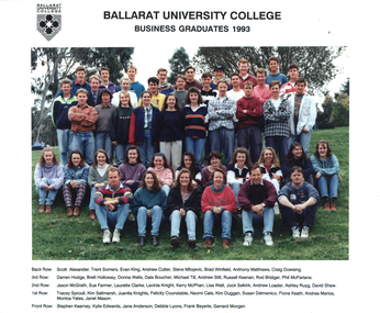
Photograph - Colour, Ballarat University College Business Graduates, 1993, 1993
Ballarat University College is a predecessor institution of Federation University AustraliaColour photograph of Ballarat University College Business Graduates taken outside on Mount Helen Campus. Back Row: Scott Alexander, Trent Somers, Evan King, Andrew Cutter, Steve Milojevic, Brad Winfield, Anthony Matthews, Craig Dowling 3rd Row: Darren Hodge, Brett Holloway, Donna Wells, Dale Boucher, Michael Till, Andrew Still, Russell Keenan, Rod Bridger, Phil McFarlane 2nd Row: Jason McGrath, Sue Farmer, Lauretta Clarke, Lavinia Knight, Kerry McPhan, Lisa Watt, Jock Selkirk, Andew Loader, Ashly Ruyg, David Shaw, Monica Yates, Janet Mason Front Row: Stephen Kearney, Kylie Edwards, Jane Anderson, Debbie Lyons, Frank Beyerle, Gerrard Morganballarat university college, business school, scott alexander, trent somers, evan king, andrew cutter, steve milojevic, brad winfield, anthony matthews, craig dowling, darren hodge, brett holloway, donna wells, dale boucher, michael till, andrew still, russell keenan, rod bridger, phil mcfarlane, jason mcgrath, sue farmer, lauretta clarke, lavinia knight, kerry mcphan, lisa watt, jock selkirk, andew loader, ashly ruyg, david shaw, monica yates, janet mason, stephen kearney, kylie edwards, jane anderson, debbie lyons, frank beyerle, gerrard morgan -
 Federation University Historical Collection
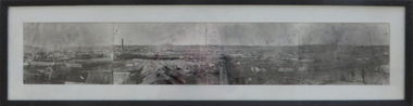
Photograph - Photograph - Black and White, Ballarat, c1858, c1858
Four photographs framed together to produce a panorama. The four photographs were taken from the slope of the Ballarat School of Mines where the Wesley Church now stands. When joined they gave a panoramic view of one of the world’s richest alluvial goldfields. The town you see had over 50,000 people. Bridge Street on the left is well established. The crude pans and cradles of the early “diggers’ were already giving way to steam power and the deep shafts of the “miners”. Money and machinery were needed to get to the deeper leads, and the smoke stacks of the great company mines can be seen across the photo. The waterloo mines was one of the first deep shafts and was sunk at the foot of the Dana Street hill. Its tailings are seen in the second photo from left. ballarat, ballarat gas works, mount warrenheip, shingle roof, mullock heap, mining -
 Ringwood and District Historical Society
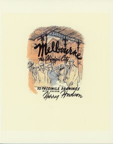
Book, Melbourne the Olympic City, subtitled 10 Facsimile Drawings With Colour - Harry Hudson
Yellow soft covered book containing Melbourne street scene sketches, photographs, and recollections contributed in 2021 by former pupils of Ringwood High School as a tribute to their well remembered art teacher, Harry Hudson (1910-1974). The images are reproduced from a folio of drawings that Harry made as a souvenir of Melbourne at the time of the 1956 Olympic Games. Contents and contributors: Flinders Street Station - Jeanette Fry Bourke Street - Graham Edney Collins Street - Michael Anderson, Thomas Guest, Eleanore Peeler Princess Theatre - John Wood, Thomas Guest Melbourne Town Hall - Thomas Guest Princes Bridge - Jeanette Fry StPaul's Cathedral - Ian McCleave Public Library - Gavin Fry Swanston Street - Peter Fry StPatrick's Cathedral - Gavin Fry. -
 Bendigo Historical Society Inc.
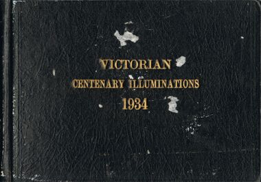
Photograph - VICTORIAN CENTENARY ILLUMINATIONS 1934
Photo album, brown hard cover, writing in gold leaf ' Victorian Centenary Illuminations 1934' Contains black and white images of Melbourne, taken at night. Includes, south bank of Yarra, Princes Bridge, Collins Street, Flinders Street, Elizabeth Street, Shrine of Remembrance, St. Kilda, Swanston Street, Hawthorn War Memorial, State Electricity Commission Head Office, Electricity supply Building, Electricity Commission and Port Authority buildings, South Melbourne Town hall, Hotel Windsor, Parliament House, Town hall, Fire Brigade building, State Savings Bank, National Bank, Melbourne town hall, Bank of Australia, Port Authority Building, Steam Tower. All the photographs in this album pertain to the City of Melbourne, and have NOT been scanned.cottage, miners, melbourne, melbourne, centenary -
 Bendigo Historical Society Inc.
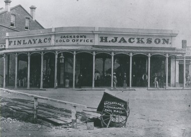
Photograph - HENRY JACKSON, GOLD BUYER OF VIEW POINT, CHARING CROSS, 1861
Black and white photograph. Single storey building with verandah. Two storey brick building at L. At least 12 adult males standing under verandah. L foreground wooden bridge / walkway. Photographer's car CF. In image on building 'Finlay & Co/Jackson's Gold Office, H Jackson'. On cart in image 'Photographer, Pall Mall'. Inclusion in envelope - typewritten is 'Henry Jackson, gold buyer of View Point, Charing Cross where Aussie Disposals are now operating. On the right is the first building of the Bank of New South Wales. The railing marked where the creek then meandered. Photograph by Batchelder, taken in 1861. (Bendigo Historical Society Inc.) History of object James Lerk 28.2.2000 Batchelder photo (copy) 1861, View Point. See Mosaic 1228 for further information.buildings, commercial, henry jackson, gold buyer -
 Bendigo Historical Society Inc.
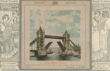
Postcard - GLADYS DEAN COLLECTION: POSTCARD, 1906 - 1908
Postcard with raised 8.5cm x 8.5cm coloured silk image of Tower Bridge London. Image has printed words 'Patent' and 'Fab Card' either side of a printed coat of arms at the top and letters W.N.S.B. bottom left corner and 'Series V No 40' bottom right corner. Image is attached to printed 14cm x 9cm black and white printed card. The words 'Fab Card' and 'The Art Patchwork Series' appear on the card either side of the image. Printed drawings of 1. two women, one seated sewing and one standing sewing and 2. two women standing examining a cloth, appear either side of the image. On reverse card is addressed to Miss G Dean McKenzie St Golden Square Victoria Australia.W N Sharpe Sole Publisher Bradfordpostcard -
 Ballarat Heritage Services
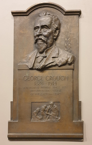
Photograph, Clare Gervasoni, Memorial Plaque to George Crouch, 07/2022
R.A. Crouch established the George Crouch Prize for contemporary art at the Ballarat Art Gallery in memory of his father. The prize an from 1927 till the 1970s.Brass plaque with a sculptural likeness of George Crouch in the Art Gallery of Ballarat. The George Crouch Prize was established by, R.A. Crouch, the son of George Crouch. memory. Thought you might want to make a correction. Obituary "A well known resident of Ballarat East in the early days. Mr George Crouch, passed away at the age of 86, at his residence, Wynnstay road, Armadale, on Wednesday. For a number of years the late Mr Crouch conducted a boot and shoe store in Bridge street, and was successful in business. He leaves a widow, two sons, amndtwo daughters, one of the sons being Lieut.-Colonel R. A. Crouch, who represented Corio in the Federal Parliament for nine years, and who is a native of Ballarat." (Ballarat Star, 9 Oct 1914 ) George Crouch 1818-1914 A Ballarat pioneer since 1852 Erected by the Council of the Gallery - 1940george crouch, art gallery of ballarat, ballarat pioneer, r.a. crouch -
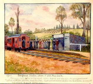 Southern Sherbrooke Historical Society Inc.
Photograph - 1906 railway accident, Belgrave
Watercolour painting by Charlie Hammond showing two train carriages at Belgrave Station. A group of people stand on the small platform beside the small station building which bears the sign 'Monbulk'. In the background are hilly paddocks. The most distant paddock has rows of what appear to be fruit trees. Below the painting Hammond has written '1901 Belgrave Station when it was Monbulk. Benson's Hill in the background. Later – Biffin's and later still – Harper's Guest House. Typical of all the stations along the line. Govt. had not recovered from the land boom and could not afford to build better ones.' This painting is based on a photo taken by Hammond in 1906, which is labelled by him, 'Sunday 28th Jany 1906. bringing the injured passengers to Belgrave Ry Station after the accident at the trestle bridge.' -
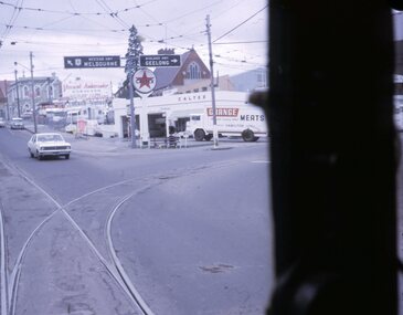 Ballarat Tramway Museum
Slide - 27 mm sq slide/s - set of 7, Lilian Butler, Mt Pleasant line, Sep. 1971
Yields information about the streetscapes of Stones Corner to Mt Pleasant route and in particular buildings and people that crewed the trams.Set of seven Colour 27 x 27 mm slide in a Kodachrome cardboard mount. .1 - Tram turning onto the Mt Pleasant line at Stones Corner - Bridge St, Main Road .2 - Main Road looking south with Inland Body Works building on the left and Ampol Service Station .3 - Mt Pleasant terminus with the butcher shop on the left and the diary on the right - shows the terminating tram track .4 - Conductor changing pole. .5 - Putting pole on the overhead .6 - Conductor (D O'Leary - No. 38) standing in front of tram and Motorman or driver (N. Hall - No. 43) .7 - ditto with number visible. See Reg item 3425 for crew lists. Slide mount date September 1971. Photo from the collection of Lilian Butler.ballarat, tramways, trams, stones corner, main road, mt pleasant, crews, drivers, conductors, trolley poles, tram 41 -
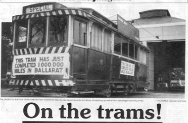 Ballarat Tramway Museum
Newspaper, The Courier Ballarat, "On the trams", 19/09/1992 12:00:00 AM
Newspaper cutting from The Courier, Ballarat, Saturday 19/9/1992, page 27, written by Seaton Ashton about the history of trams in Ballarat on the 20th anniversary of their closure. Notes horse trams, ESCo, opening of lines, tram car builders, their rehabilitation in the 1930's, the involvement of the BTPS, trams 1 and 12. Has two photos, one of tram 27 sitting outside the SEC depot carrying the "This tram has just completed 1,000,000 miles in Ballarat" and one of tram 31, east bound in Bridge St. bound for Victoria St. dropping off a passenger at a stop. Both picture from the Courier Archives. Item in the Courier's "Saturday Magazine". Occupies a full page of the newspaper. 2nd copy added 11/8/2001 - folded.trams, tramways, ballarat, esco, btps, horse trams, sec -
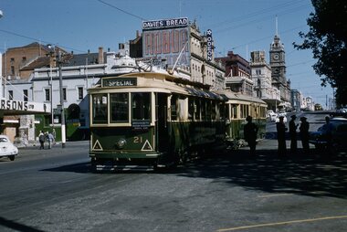 Ballarat Tramway Museum
Slide - 35mm slide/s, Ben Parle, 5/04/1958 12:00:00 AM
Kodachrome Transparency - 35mm slide - cardboard mount, with one side with red border and words "Kodachrome Transparency / Processed by Kodak" top and bottom. Photo taken by Ben Parle 5/4/1958. Has slide No. "13" stamped in red in top corner. Photo of the No. 21 and 41in the Sturt St. City Loop, with a number of SEC crewmen standing in the shadows, while on the AETA tour. No. 21 has destination of Special. Both trams are carrying the AETA special car auxiliary signs. Trams have been reversed in the loop, and possibly to run "bang road" to Bridge St. Has the Odeon theatre in the background, advertisements for Robur Tea, Davies Bread. Note the Pie / Pasties sign on the building behind 21. For high resolution scan see btm2847h.tif"City Loop" "-5-4-58"tramways, trams, sturt st, city loop, tram 21, tram 41 -
 Ballarat Tramway Museum
Magazine, Australian Railway and Locomotive Historical Society, "ARLHS Bulletin", 1942
Yields information about the tramways of Ballarat and the North Melbourne tramways and has a strong association with well known tramway enthusiasts of the era., Yields information about the tramways of Ballarat and the North Melbourne tramways and has a strong association with well known tramway enthusiasts of the era.Set of 8 Australian Railway and Locomotive Historical Society Bulletins for the period May 1942 to December 1942. Each page has been stencil duplicated. Index sheets for the journals at the front of the documents. The sheets have been placed in a heavy brown flysheet and then placed in "The Riven" spring back binder. May 1942 - page 57 to 59 - has a article, Horse Trams of Ballarat 1887 to 1913" written by Wal Jack, including a map prepared by C. C. Singleton. June 1942 - page 82 & 83 - has an article "Electric Trams of Ballarat 1905 to 1942" written by Wal Jack. November 1942 - page 65 & 66, has an article "Flemington Bridge Tramways, The North Melbourne Electric Tramway and Lighting Company" written by Peter W Duckett.ballarat, esco, nmetl, melbourne, horse trams, electrification -
 Ballarat Tramway Museum
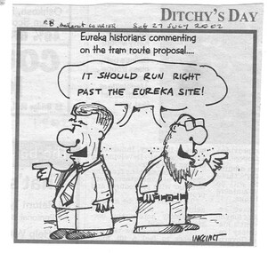
Newspaper, The Courier Ballarat, "Trams were hard for many to board", "Parking is more important than trams", "Trams are not the best investment", Jul. 2002
Yields information about the view of letter writers about the proposal for a Ballarat Tourist based tramway in 2002.Set of three newspaper clippings about the return or revival of a tourist tramway in Ballarat. .1 - Cartoon by Inkcinct - The Courier Saturday 27 July 2002 - about Eureka Historians commenting on the tram route proposal. .2 - Newspaper clipping - six different letters - from The Courier, Saturday 27 July 2002, first letter titled "Trams were hard for many to board" - written by David Stabb, Doug Wiseman, Shane Canny, Peggy Nijam, M. Parr, Mary Glenane. .3 - Newspaper clipping - six different letters - from The Courier, Wednesday 17 July 2002, first letter titled "Trams are not the best investment", written by Bob Orr, Keith Vanstan, Walter Robson, Tom Evans, Brian Coffey and Pauline Shaw - re Peter Hiscock and the Bridge Mall. Each item has the date, source and page written in ink.ballarat revival, btm, city tramway, bridge st, bridge mall -
 Ballarat Tramway Museum
Document - Instruction, State Electricity Commission of Victoria (SECV), "Forest City Signals", late 1960's?
Yields information about the instructions about Signalling system on Wendouree Parade and Bridge St - Forest City signals.Five page, foolscap duplicated document, stapled in the top left hand corner, titled Forest City Signals, undated, has letters S4 in top right hand corner of first sheet, giving details about the Forest City signalling system installed in Ballarat, particularly around Wendouree Parade and the depot. Explains how the system operates, gives instructions, details of the system, location of the loops, trams following each other, power failure. Also gives details of how the Bridge St system operated and the switch at Grenville St. Note: The locations of the signals may not be not as detailed as in the Driver Training Manual - See Reg Item 3486. Does not provide instructions for Lydiard St North or Sebastopol routes. See also Reg Item 3456 for another similar copy.trams, tramways, signals, crossing loop, forest city signals, grenville st, wendouree parade -
Bendigo Historical Society Inc.
Document - LYDIA CHANCELLOR COLLECTION: BENDIGO METHODIST CHURCHES PLAN 1905 AND CHURCH OFFICIALS, 1905
LYDIA CHANCELLOR COLLECTION: Bendigo Methodist Churches Plan 1905 and church officials Quarterly Pastoral Visitation of Classes Circuit plan for Forest St, Golden square, Eaglehawk West, Eaglehawk East, California Hill, California Gully, Long Gully, McKenzie St, Galvin St, Rowan St, Arnold St, Iron Bark, Buckly St, Specimen Hill, Quarry Hill, Bridge St, Retreat Road, Kangaroo Flat, Lockwood, East Shelbourne, White Hills, Epsom, Huntly, Bagshot, fosterville, Strathfieldsaye, Axe Creek, sheepwash, Nerring, Leichardt, Leichardt East, Marong, Golden Fleece, Golden Gully, Dowling St Mission, Benevolent Asylum, Hospital Income and Expenditure List of stewards Notices Pastorates Evangelistic Bandsbendigo, history, schooling