Showing 11257 items
matching tea-tree
-
 Eltham District Historical Society Inc
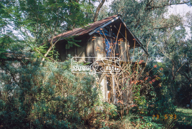
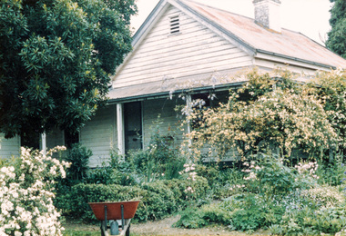
Slide - Photograph, Macgregor Knox House, John Street, Eltham, 23 May 1993
Macgregor Knox house (1976) - a small building of note on the Knox property. It is an attic bedroom that Alistair's son, Macgregor, built for himself when he was fifteen. The 1993 Eltham Heritage Tour was enjoyed by a busload of members of the Historical Society on a fine, calm day, Sunday May 23rd. Between 10.00 am and 4.30 pm, except for a brief lunch stop at the Eltham Living and Learning Centre, members passed about thirty places of local interest and others recommended for the Historic Buildings Register and the Register of the National Estate. A number of significant trees and buildings were also highlighted along with the opportunity to explored some of the properties.35mm colour positive transparency (1 of 24) Mount - Kodak Kodachromeactivities, shire of eltham historical society, heritage excursion, eltham, houses, macgregor knox house, mudbrick -
 Eltham District Historical Society Inc
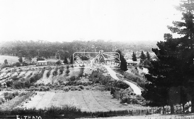
Negative - Photograph, Bridge Street, Eltham, c.1910
View from Maria Street (Main Road) along Bridge Street, Eltham, looking towards Montmorency. The house on the right at the corner of Susan and Bridge streets was owned for many years by the Hill family until Council bought it in the early 1960s. The house was built in the 1850s or 60s. The house on the left stood on what is now the southwest corner of Susan and Bridge Streets. The Braithwaite family was associated with this house. Orchards in the foreground either side of the Diamond Creek. The line of trees running up the hill to the left represents the Bolton street alignment. Based on hand writing of title on image compared with others, date is estimated at c.1910.This photo forms part of a collection of photographs gathered by the Shire of Eltham for their centenary project book,"Pioneers and Painters: 100 years of the Shire of Eltham" by Alan Marshall (1971). The collection of over 500 images is held in partnership between Eltham District Historical Society and Yarra Plenty Regional Library (Eltham Library) and is now formally known as the 'The Shire of Eltham Pioneers Photograph Collection.' It is significant in being the first community sourced collection representing the places and people of the Shire's first one hundred years.Digital image 4 x 5 inch B&W Negshire of eltham pioneers photograph collection, bolton steet, braithwaite, bridge, bridge street, bridge street bridge, eltham, hill family home, susan street, orchards -
 Eltham District Historical Society Inc
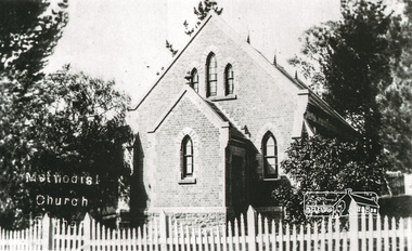
Photograph, Tom Prior, Methodist Church, Eltham
Situated at 810 Main Road on the corner of John Street. The Church was surrounded by a picket fence and tall pine trees. The Church was built by George Stebbings in the 1850s and is an example of fine craftmanship. Formerly Wesleyan, Methodist then Uniting church; the foundations of the church building were constructed with stone from the walls of the first Eltham State Primary School (No. 209) building which collapsed in 1874 and were purchased by Robert David Taylor. The Reynolds/Prior Photograph Collection, Presented to the Eltham District Historical Society, 14 June 2006 by Ross McDonald. A second copy was also presented to the Andrew Ross Museum, Kangaroo Ground The Reynolds family were early settlers in Research. Reynolds Road is named after this family. RERVISED STATEMENT OF SIGNIFICANCE, CONTEXT, 2010 What is significant? The 1880 bichromatic brick church and the surrounding site to the title boundaries. The church is architecturally, historically, socially and spiritually significant to the Shire of Nillumbik. Why is it significant? The church is architecturally significant as a finely detailed example of a brick 19th century rural community church, one of only four in the Shire (Criteria E & B). The church is historically significant as an important link with the time when Eltham was a small, insular country settlement. Also for the historical evolution visible in the complex, with the modest 1880s church and larger red brick rear hall from the early 20th century as a reflection of population growth in the area (Criterion A). The church is historically, spiritually and socially significant because it has played, and continues to play, an important part in the spiritual and social life of the community (Criterion G). - Victorian Heritage Database The Reynolds family were early settlers in Research. The Reynolds/ Prior collection of photographs were taken by Tom Prior, the maternal uncle of Ivy Reynolds, around 1900 and the 60 photos in the album give a fine overview of many of the landmarks of Research and Eltham over 100 years ago. lvy lived in the family home for many years at 106 Thompson Cres Research. Ivy's father, Ernst Richard Reynolds and grandfather, Richard Reynolds, lived at the same address. Ivy's father Richard worked for Mr. Trail on his property in Research. Reynolds Road is named after the family. Mr Tom Prior (wife Eva) worked at the Melbourne zoo. He was very innovative and made his own camera, using the black cloth hood to exclude the light. The photographs are a reminder of the rural nature of Research and Eltham and its rich heritage. Black and white photograph mounted in an album, the Reynolds/Prior Photograph Collection, this being one of 53 reproduced black and white images of early Eltham."Methodist Church" reynolds prior collection, eltham, methodist church -
 Eltham District Historical Society Inc
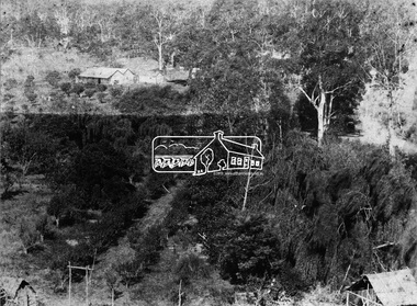
Negative - Photograph, J. P. Lind, Hurst's Bridge, 1885
Looking northwest onto the first bridge at Hurstbridge, 1885. Timber bridge amid rural setting. Two horses graze in an open paddock in the foreground. A house is situated on a rise behind the bridge on a tree lined hill. The area of Hurstbridge was originally known as Hurst’s-bridge after the timber bridge built over the Diamond Creek near Hurst’s station in late 1881/early 1882 on the Hurstbridge-Arthurs Creek Road, Hurstbridge. It was built by John McDonald, of Arthur's Creek and was demolished and replaced in 1917 by a reinforced concrete arch bridge designed by John Monash. Cross Reference Photo No.(s): 1012/1013This photo forms part of a collection of photographs gathered by the Shire of Eltham for their centenary project book, "Pioneers and Painters: 100 years of the Shire of Eltham" by Alan Marshall (1971). The collection of over 500 images is held in partnership between Eltham District Historical Society and Yarra Plenty Regional Library (Eltham Library) and is now formally known as 'The Shire of Eltham Pioneers Photograph Collection.' It is significant in being the first community sourced collection representing the places and people of the Shire's first one hundred years.Digital image 4 x 5 inch B&W Negshire of eltham pioneers photograph collection, hurstbridge, bridge, diamond creek (river), diamond creek (creek), hurst's bridge -
 Eltham District Historical Society Inc
Photograph, Allwood, Hurstbridge, 1885
Allwood at Hurstbridge was named and first settled in 1837 by the Haley family. A house was built of one round of vertical slabs (red gum). Later it was the Hurst family home where Henry Hurst was shot by Burke the Bushranger on 4 October 1886. George Gray took over the property and the original home was eventually demolished. Gray, a fruit grower established an orchard and Allwood Nurseries which became a very successful business growing and exporting. This is probably around the time when this photo was taken where rows of fruit trees can be seen in the foreground. A house and associated buildings, possibly part of the nursery are behind. This photo forms part of a collection of photographs gathered by the Shire of Eltham for their centenary project book, "Pioneers and Painters: 100 years of the Shire of Eltham" by Alan Marshall (1971). The collection of over 500 images is held in partnership between Eltham District Historical Society and Yarra Plenty Regional Library (Eltham Library) and is now formally known as 'The Shire of Eltham Pioneers Photograph Collection.' It is significant in being the first community sourced collection representing the places and people of the Shire's first one hundred years.Digital imagesepp, shire of eltham pioneers photograph collection, diamond creek, hurstbridge, allwood, orchard -
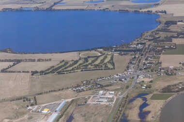 Lake Bolac & District Historical Society
Colour photograph, Aerial view of Lake Bolac and village. After the rain, 2010
Aerial view of Lake Bolac after the drought had broken in late 2010. The fresh-water lake is now full, as are the wetlands. Note the edge of the salt-lake in the bottom right, the Industrial Estate bottom left and centre, the golf course, the current footy oval, Bowling Club, tennis courts and swimming pool with the P-12 College through the trees on the bank of the lake. An Archaeologist might be able to discern the original footy oval bottom centre, built on what was once the town Common (below the industrial buildings),and the second oval (above the salt lake.) The houses are spreading along the west bank of the lake beyond the school.lake bolac, 2010, village, fresh-water lake, salt lake, golf, tennis, bowling, swimming, college, -
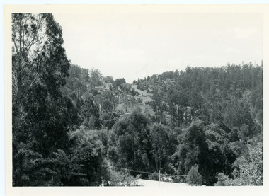 Mt Dandenong & District Historical Society Inc.
Photograph, View From Doughty's Road 1974
John Lundy-Clarke grew up in the Kalorama/Mt Dandenong area and later in life (1972-74) began to write a comprehensive history of the area working from an original settlement map in an effort to cover all areas. This photograph shows approximately the same area as photograph number KAL0193 but is taken 60 years later. The trees have grown much taller and the buildings changed. On the site of the Paynter house 'Iona' there is now the 'Yosemite' (Villa Toscana) accommodation. The pavilion in the centre of the photo is the site of 'Kalorama', home of early pioneer Isaac Jeeves. The photograph is taken looking up towards The Gap (FiveWays).Black and white photograph showing a forested area with clear sites. Roofs of buildings can be clearly seen. Handwritten inscription on reverse by John Lundy-ClarkeView from near Doughty’s Rd looking north up valley to Kalorama Gap in Jan 1973. Tiny roof in centre is pavilion on site of “Kalorama”. Long roof to its left is Yosemite Motel on site of “Iona”.paynter, kalorama, iona, yosemite, villa toscana, five ways, the gap -
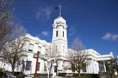 Glen Eira City Council History and Heritage Collection
Photograph - Building, Glen Eira Town Hall, 1884
Originally known as Caulfield Shire Hall, the original 1884 building was designed by Shire surveyor Sydney Smith. In 1931 the Caulfield Town Hall, as it was then known, was remodelled to include the main hall and foyer and a Neo-Grecian portico with Corinthian Order columns. Major works completed since 1945 include Caulfield Arts Complex (opened 20 August 1988), Caulfield Library (opened 4 December 1993) and the award-winning Caulfield Municipal Offices extension which opened on 24 February 1991. The building is listed as No. H0106 in the GECC Heritage Overlay Schedule. The site also includes a Significant Tree (H&H Register No. 034). Brick exterior of two storey building painted white and featuring pillared portico entrance and solid glass doors on Glen Eira road facing north. On the eastern side of the portico is a two storey clock tower with clock surmounted by a flagpole and flag. Some of the eastern section of the building is original with various alterations over the years. The award winning service centre and offices in the westerly aspect of the town hall were extended on to the original buliding in 2000.building, town hall, council, local government, caulfield, glen eira, moorabbin, sydney smith -
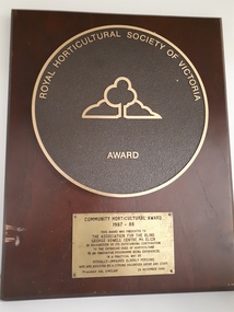 Vision Australia
Photograph - Image, Royal Horticultural Society of Australia award, 1988
A metal circle sits on a brown wooden board. Within the circle are the words 'Royal Horticultural Society of Victoria' around the upper edge, an outline of a tree with a bush either side in the middle of the circle, and 'Award' below this. A gold coloured plate rests below this and reads: Community Horticultural Award 1987-88 This award was presented to The Association for the Blind George Vowell Centre, Mt Eliza in recognition of its outstanding contribution to the extensive uses of horticulture in an innovative programme being experienced in a practical way by visually-impaired elderly persons who are assisted by a strong volunteer group and staff. President: Val Sinclair 26 November 1988Wooden rectangle with 1 large round and 1 rectangular plaqueassociation for the blind, george vowell centre (mt eliza), awards, royal horticultural society of victoria -
 Bacchus Marsh & District Historical Society
Plaque, Shire of Bacchus Marsh Coat of Arms
Coat of Arms used by the Shire of Bacchus Marsh in the 1980s and 1990s. A coat of arms has been in use in the Shire at least from the early 20th century. This earlier coat of arms described in 1910 featured two cows standing on two bales of lucerne hay, with lucerne fields and fruit trees and rolling hills all round a central valley with two rivers running through it. This early coat of arms was superseded by the slightly different design shown here. When this change took place is not known. When the Bacchus Marsh Shire amalgamated with other Shires to form Moorabool Shire in 1994 this design was superseded.The plaque showing the Bacchus Marsh Shire Coat of Arms is in near perfect condition and as such is an excellent example of the physical symbols used to demonstrate the presence of local government in the Bacchus Marsh region. The images on the coat of arms also depict key economic and agricultural activities in the region which provides historical information about the region in a visual and artistic way.Painted cast bronze plaque with inscription on outer white band in black capital lettering: SHIRE OF BACCHUS MARSH. Inner circle painted blue with shield and decorative branches bearing yellow leaves on either side. Shield quartered and surmounted by stylised sunrise. In four quarters, representations of significant local primary and secondary industries. SHIRE OF BACCHUS MARSH.coats of arms, shire of bacchus marsh -
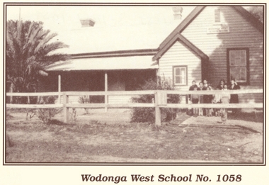 Wodonga & District Historical Society Inc
Photograph - Wodonga West School No. 1058
Wodonga West School opened on 24 January 1870 and closed on 9 May 1950. It was located near the current intersection of McKoy Street and the Hume Freeway in West Wodonga on land donated by J.W. Klinge. The school replaced an older school, “Green Hills School, which was located north of the railway line. A public telephone was installed at the school and the mail service operated from the school three days each week. In 1935 a row of 15 ornamental trees was planted along the boundary fence, one for each of the pupils at the school. When this school closed the nine remaining students were transferred to Wodonga Primary School.This image is significant because it documents the early developments in the provision of education in Wodonga, Victoria A black and white photo of a group of children standing outside the Wodonga West School building.wodonga schools, wodonga west primary school, education wodonga -
 Wooragee Landcare Group
Photograph, 27th August 2004
Taken on the 27th August 2004 the photographs shows attendees of the Direct Seeding Expo that took place at Wooragee Hall socialising and eating during a lunch break. Direct seeding involves the seeds being sowed directly into the soil to achieve germination and establishment. Direct seeding is said to mimic natural processes and can result in trees and shrubs growing healthier root systems. Direct seeding is best for larger areas and can be done at a lower cost. As the Wooragee community values nature, this expo brought together members from the community in order the educate them on direct seeding which would then benefit the community. This photograph is significant at the Wooragee community values nature and believes in replacing what has been lost. Thus, the photograph demonstrates the communities commitment to ensuring the preservation of nature through education of seeding practices.Coloured rectangular photograph printed on gloss photographic paper Reverse: WAN NA E0NA2N2. NNN 0 3585 (No.22) 347wooragee, wooragee landcare, direct seeding expo, 2004 -
 Eltham District Historical Society Inc
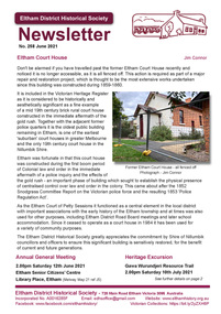
Newsletter, Newsletter, No. 258 June 2021
Contents: • Eltham Court House by Jim Connor • Fifty Years Ago In Eltham South; A historic tree planting by Michael Aitken • Heritage Excursion –Saturday 10th July • A Mud Brick Meander by Jim Connor • Eltham Watering Place Reserve (Shire of Eltham Heritage Study appendix 1-2) • Eltham Wurundjeri History by Jan Aitken • A Well Deserved Award of Merit by Jim Connor • Annual General Meeting - 2.00pm, Saturday 12th June 2021 • Eltham Cemetery Stories by Richard Pinn o Pauline Therese Toner o Bertram Barney Wainer • Contacts for the Eltham District Historical SocietyThe Shire of Eltham Historical Society was formed in October 1967. The first newsletter of the Society was issued May 1978 and has been published continuously ever since on a bi-monthly basis. With the cessation of the Shire of Eltham in late 1994, the Society's name was revised to Eltham District Historical Society and this name first appeared with issue No. 103, July 1995. The collection of the Society's newsletters provides a valuable resource on the history of the Society's activities, office bearers and committee members, guest speakers and subjects of historical interest pertinent to the former Shire of Eltham and the Eltham District.A4 newsletter distributed to members (Digital and A4 photocopy)newsletter, eltham district historical society, covid-19, coronavirus pandemic -
 Ballarat Heritage Services
Photograph - Photograph - Colour, Clare Gervasoni, Toilet at St Laurence O'Toole Catholic Church, Sandon, 2017, 08/04/2023
St Laurence O'Toole church and cemetery is located in a rural setting at 801/821 Creswick-Newstead Rd, Sandon. Originally a small wooden school (22’x14’) was erected in Sandon by Father Patrick Smyth (who was involved in the Eureka Stockade movement) in 1859. It was also used for Mass and became known as a chapel. In June 1882 tenders were called for the construction of a brick Church by the Castlemaine architect, T.F. Kibble, and it was built at a cost of 1000 pounds. The church was blessed by Archbishop Goold on 06 May 1883 and dedicated to St Laurence O'Toole. The brick building demonstrates original design qualities of a Victorian Rudimentary Gothic style, including the steeply pitched, parapet gable roof form, together with a central steeply pitched, gabled porch that projects slightly from the main gable end. Other intact qualities include the exposed brick wall construction, lapped galvanised corrugated iron roof cladding, minor gabled porch at the rear, small ventilation dormers nearby the roof ridgeline, series of stone steps that lead to the central porch with its double pointed door opening and vertical boarded doors, simple rose window in the main gable end, pointed windows, brick buttresses with double lower copings, and the light masonry detailing (the banding marking the floor level within, buttress copings, window and door surrounds and quoins, and the drip moulds).(Shire of Mount Alexander: Heritage Study of the former Shire of Newstead, 2000) The visually connected cemetery demonstrates important visual qualities formed by the regular rows of graves and cemetery architecture, and the grassed and treed rural landscape. It is a rare and substantially intact example of a Victorian Catholic Church with a cemetery in its churchyard. Many headstones and cemetery architecture, date from the 19th century and represent some fine examples of masonry craftsmanship. Some refurbisments occurred during the 1940s and in 2002 a major restoration project was undertaken from roof to footings, by a dedicated band of volunteers and trades people. Work was completed mid 2003 and in November 2003 St Laurence’s was re-dedicated with the celebration of Mass and a picnic tea. Colour photograph of a long drop toliet at the Catholic Church, Sandon, Victoria.sandon, sandon cemetery, st laurence o'toole catholic church, sandon -
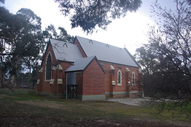
 Ballarat Heritage Services
Photograph - Photograph - Colour, Lisa Gervasoni, St Laurence O'Toole Catholic Church, Sandon, 2017, 16/07/2017
St Laurence O'Toole church and cemetery is located in a rural setting at 801/821 Creswick-Newstead Rd, Sandon. Originally a small wooden school (22’x14’) was erected in Sandon by Father Patrick Smyth (who was involved in the Eureka Stockade movement) in 1859. It was also used for Mass and became known as a chapel. In June 1882 tenders were called for the construction of a brick Church by the Castlemaine architect, T.F. Kibble, and it was built at a cost of 1000 pounds. The church was blessed by Archbishop Goold on 06 May 1883 and dedicated to St Laurence O'Toole. The brick building demonstrates original design qualities of a Victorian Rudimentary Gothic style, including the steeply pitched, parapet gable roof form, together with a central steeply pitched, gabled porch that projects slightly from the main gable end. Other intact qualities include the exposed brick wall construction, lapped galvanised corrugated iron roof cladding, minor gabled porch at the rear, small ventilation dormers nearby the roof ridgeline, series of stone steps that lead to the central porch with its double pointed door opening and vertical boarded doors, simple rose window in the main gable end, pointed windows, brick buttresses with double lower copings, and the light masonry detailing (the banding marking the floor level within, buttress copings, window and door surrounds and quoins, and the drip moulds).(Shire of Mount Alexander: Heritage Study of the former Shire of Newstead, 2000) The visually connected cemetery demonstrates important visual qualities formed by the regular rows of graves and cemetery architecture, and the grassed and treed rural landscape. It is a rare and substantially intact example of a Victorian Catholic Church with a cemetery in its churchyard. Many headstones and cemetery architecture, date from the 19th century and represent some fine examples of masonry craftsmanship. Some refurbisments occurred during the 1940s and in 2002 a major restoration project was undertaken from roof to footings, by a dedicated band of volunteers and trades people. Work was completed mid 2003 and in November 2003 St Laurence’s was re-dedicated with the celebration of Mass and a picnic tea. Colour photograph of a brick church at Sandon, Victoria.sandon, sandon cemetery, st laurence o'toole catholic church, sandon -
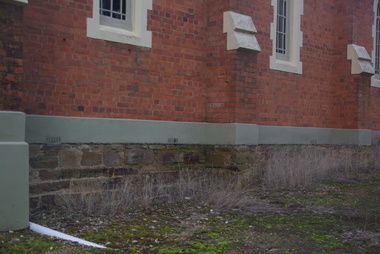 Ballarat Heritage Services
Photograph - Photograph - Colour, Clare Gervasoni, Sandstone foundations at St Laurence O'Toole Catholic Church, Sandon, 2017, 16/07/2017
St Laurence O'Toole church and cemetery is located in a rural setting at 801/821 Creswick-Newstead Rd, Sandon. Originally a small wooden school (22’x14’) was erected in Sandon by Father Patrick Smyth (who was involved in the Eureka Stockade movement) in 1859. It was also used for Mass and became known as a chapel. In June 1882 tenders were called for the construction of a brick Church by the Castlemaine architect, T.F. Kibble, and it was built at a cost of 1000 pounds. The church was blessed by Archbishop Goold on 06 May 1883 and dedicated to St Laurence O'Toole. The brick building demonstrates original design qualities of a Victorian Rudimentary Gothic style, including the steeply pitched, parapet gable roof form, together with a central steeply pitched, gabled porch that projects slightly from the main gable end. Other intact qualities include the exposed brick wall construction, lapped galvanised corrugated iron roof cladding, minor gabled porch at the rear, small ventilation dormers nearby the roof ridgeline, series of stone steps that lead to the central porch with its double pointed door opening and vertical boarded doors, simple rose window in the main gable end, pointed windows, brick buttresses with double lower copings, and the light masonry detailing (the banding marking the floor level within, buttress copings, window and door surrounds and quoins, and the drip moulds).(Shire of Mount Alexander: Heritage Study of the former Shire of Newstead, 2000) The visually connected cemetery demonstrates important visual qualities formed by the regular rows of graves and cemetery architecture, and the grassed and treed rural landscape. It is a rare and substantially intact example of a Victorian Catholic Church with a cemetery in its churchyard. Many headstones and cemetery architecture, date from the 19th century and represent some fine examples of masonry craftsmanship. Some refurbisments occurred during the 1940s and in 2002 a major restoration project was undertaken from roof to footings, by a dedicated band of volunteers and trades people. Work was completed mid 2003 and in November 2003 St Laurence’s was re-dedicated with the celebration of Mass and a picnic tea. Details of the exterior of St Laurence O'Toole Catholic Church, Sandon in Central Victoria.sandon, sandon cemetery, st laurence o'toole catholic church, sandon, sandstone, foundations -
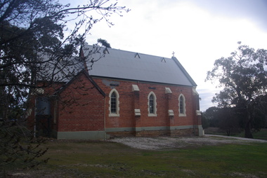
 Ballarat Heritage Services
Photograph - Photograph - Colour, Clare Gervasoni, St Laurence O'Toole Catholic Church, Sandon, 2017, 16/07/2017
St Laurence O'Toole church and cemetery is located in a rural setting at 801/821 Creswick-Newstead Rd, Sandon. Originally a small wooden school (22’x14’) was erected in Sandon by Father Patrick Smyth (who was involved in the Eureka Stockade movement) in 1859. It was also used for Mass and became known as a chapel. In June 1882 tenders were called for the construction of a brick Church by the Castlemaine architect, T.F. Kibble, and it was built at a cost of 1000 pounds. The church was blessed by Archbishop Goold on 06 May 1883 and dedicated to St Laurence O'Toole. The brick building demonstrates original design qualities of a Victorian Rudimentary Gothic style, including the steeply pitched, parapet gable roof form, together with a central steeply pitched, gabled porch that projects slightly from the main gable end. Other intact qualities include the exposed brick wall construction, lapped galvanised corrugated iron roof cladding, minor gabled porch at the rear, small ventilation dormers nearby the roof ridgeline, series of stone steps that lead to the central porch with its double pointed door opening and vertical boarded doors, simple rose window in the main gable end, pointed windows, brick buttresses with double lower copings, and the light masonry detailing (the banding marking the floor level within, buttress copings, window and door surrounds and quoins, and the drip moulds).(Shire of Mount Alexander: Heritage Study of the former Shire of Newstead, 2000) The visually connected cemetery demonstrates important visual qualities formed by the regular rows of graves and cemetery architecture, and the grassed and treed rural landscape. It is a rare and substantially intact example of a Victorian Catholic Church with a cemetery in its churchyard. Many headstones and cemetery architecture, date from the 19th century and represent some fine examples of masonry craftsmanship. Some refurbisments occurred during the 1940s and in 2002 a major restoration project was undertaken from roof to footings, by a dedicated band of volunteers and trades people. Work was completed mid 2003 and in November 2003 St Laurence’s was re-dedicated with the celebration of Mass and a picnic tea. Brick church at Sandon, Victoriasandon, sandon cemetery, st laurence o'toole catholic church, sandon -
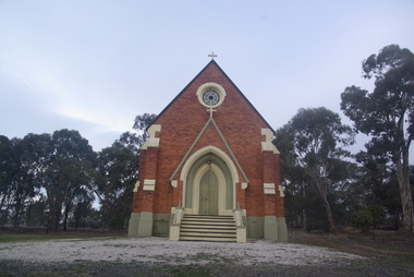
 Ballarat Heritage Services
Photograph, Clare Gervasoni, St Laurence O'Toole Catholic Church, Sandon, 2017, 16/07/2017
St Laurence O'Toole church and cemetery is located in a rural setting at 801/821 Creswick-Newstead Rd, Sandon. Originally a small wooden school (22’x14’) was erected in Sandon by Father Patrick Smyth (who was involved in the Eureka Stockade movement) in 1859. It was also used for Mass and became known as a chapel. In June 1882 tenders were called for the construction of a brick Church by the Castlemaine architect, T.F. Kibble, and it was built at a cost of 1000 pounds. The church was blessed by Archbishop Goold on 06 May 1883 and dedicated to St Laurence O'Toole. The brick building demonstrates original design qualities of a Victorian Rudimentary Gothic style, including the steeply pitched, parapet gable roof form, together with a central steeply pitched, gabled porch that projects slightly from the main gable end. Other intact qualities include the exposed brick wall construction, lapped galvanised corrugated iron roof cladding, minor gabled porch at the rear, small ventilation dormers nearby the roof ridgeline, series of stone steps that lead to the central porch with its double pointed door opening and vertical boarded doors, simple rose window in the main gable end, pointed windows, brick buttresses with double lower copings, and the light masonry detailing (the banding marking the floor level within, buttress copings, window and door surrounds and quoins, and the drip moulds).(Shire of Mount Alexander: Heritage Study of the former Shire of Newstead, 2000) The visually connected cemetery demonstrates important visual qualities formed by the regular rows of graves and cemetery architecture, and the grassed and treed rural landscape. It is a rare and substantially intact example of a Victorian Catholic Church with a cemetery in its churchyard. Many headstones and cemetery architecture, date from the 19th century and represent some fine examples of masonry craftsmanship. Some refurbisments occurred during the 1940s and in 2002 a major restoration project was undertaken from roof to footings, by a dedicated band of volunteers and trades people. Work was completed mid 2003 and in November 2003 St Laurence’s was re-dedicated with the celebration of Mass and a picnic tea. Colour photograph of a red brick church in Sandon. sandon, sandon cemetery, st laurence o'toole catholic church, sandon -
 Ballarat Heritage Services
Photograph - Photograph - Colour, Clare Gervasoni, Treed road behind St Laurence O'Toole Catholic Church, Sandon, 2017, 16/07/2017
St Laurence O'Toole church and cemetery is located in a rural setting at 801/821 Creswick-Newstead Rd, Sandon. Originally a small wooden school (22’x14’) was erected in Sandon by Father Patrick Smyth (who was involved in the Eureka Stockade movement) in 1859. It was also used for Mass and became known as a chapel. In June 1882 tenders were called for the construction of a brick Church by the Castlemaine architect, T.F. Kibble, and it was built at a cost of 1000 pounds. The church was blessed by Archbishop Goold on 06 May 1883 and dedicated to St Laurence O'Toole. The brick building demonstrates original design qualities of a Victorian Rudimentary Gothic style, including the steeply pitched, parapet gable roof form, together with a central steeply pitched, gabled porch that projects slightly from the main gable end. Other intact qualities include the exposed brick wall construction, lapped galvanised corrugated iron roof cladding, minor gabled porch at the rear, small ventilation dormers nearby the roof ridgeline, series of stone steps that lead to the central porch with its double pointed door opening and vertical boarded doors, simple rose window in the main gable end, pointed windows, brick buttresses with double lower copings, and the light masonry detailing (the banding marking the floor level within, buttress copings, window and door surrounds and quoins, and the drip moulds).(Shire of Mount Alexander: Heritage Study of the former Shire of Newstead, 2000) The visually connected cemetery demonstrates important visual qualities formed by the regular rows of graves and cemetery architecture, and the grassed and treed rural landscape. It is a rare and substantially intact example of a Victorian Catholic Church with a cemetery in its churchyard. Many headstones and cemetery architecture, date from the 19th century and represent some fine examples of masonry craftsmanship. Some refurbisments occurred during the 1940s and in 2002 a major restoration project was undertaken from roof to footings, by a dedicated band of volunteers and trades people. Work was completed mid 2003 and in November 2003 St Laurence’s was re-dedicated with the celebration of Mass and a picnic tea. Colour photograph of bushland behind a church at Sandon, Victoria.sandon, sandon cemetery, st laurence o'toole catholic church, sandon, landscape, road -
 Flagstaff Hill Maritime Museum and Village
Domestic object - Food Safe, Willow Ware Pty Ltd, 1920-1950
Willow started business in 1887 as a metal working company based in Melbourne Australia, making tinned biscuit and tea canisters. The outbreak of the First World War saw their manufacturing change to making armaments and essential packaging for the war effort. In the early 1920’s, the Willow brand was established. Making tin plated canisters and baking pans with the well-known Willow pattern, imprinted on them. Some other items in production at this time include billies, boilers, basins and Coolgardie safes. In the late 1950’s, the company ventured into plastics production. Stepping away from its very successful tin plating industry of more than 50 years. In 1965, the company name changed to Willow Ware Pty Ltd, to be more closely linked to its Willow brand. Willow Ware is still in business today. A food safe known as a “Coolgardie” meat storage made by an emerging Australian company no longer in bushiness. This item gives a snapshot into early Australian manufacturing specifically aimed at the Australian market. Safe metal kitchen safe with two shelves, a hinged door and latch and a small swivel wire handle at the top. cream colour . "Made in Australia" "Willow" warrnambool, shipwrecked-coast, flagstaff-hill, flagstaff-hill-maritime-museum, shipwreck-coast, flagstaff-hill-maritime-village, willow ware, domestic item, coolgardie meat safe, meat safe, food safe, food preservation -
 Warrnambool and District Historical Society Inc.
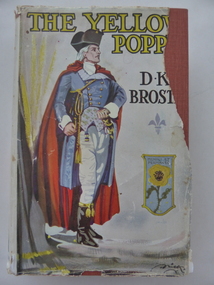
Book, The Yellow Poppy by D K Broster, 1937
This book comes from the property of Lyndoch near the mouth of the Hopkins River. George Rolfe, a tea merchant from Melbourne, established Lyndoch in 1875 and Miss Florence Lake, daughter of Miss Annie Lake, later Mrs George Rolfe, inherited the property with her sister Annie. In 1920 Florence Lake built a large house called Lyndoch. She had a Rolls Royce car and a chauffeur and was a tireless worker for local charities. Florence Lake died in 1946 and the property became the site of an Aged Care Facility in Warrnambool. Florence Lake’s house now forms part of the hostel section of this facility. This book would have been in the Lyndoch library during Florence Lake’s time there. D K Broster ( Dorothy Kathleen) was a popular writer of historical novels in the early part of the 20th century. The Flight of the heron being her most acclaimed This book is of interest as it came from the historically-important property and house known as Lyndoch and so it is connected to Miss Florence Lake, a prominent person in Warrnambool in the first half of the 20th century. This is a hard cover book of 439 pages. It has a red cover with black lettering on the front and spine. It also has a dust cover which has a colour image of a man in late 18th century attire and a shield containing a yellow poppy. The dust cover is partly torn away. The book has 46 chapters. The inscription is handwritten in black ink. ‘Lyndoch Xmas 1937’lyndoch, florence lake, history of warrnambool -
 Halls Gap & Grampians Historical Society
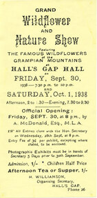
Flyer - Coloured, C 1938
Annual wildflower shows took over the Hall's Gap Hall during spring and, in the 1930's, transformed it into a veritable wonderland. So popular were these displays that they have continued through until present times, the format has altered but the display of flowers remains the same. Ladies' Committees were formed to sell art and crafts during shows, and much of the revenue from these events went towards a future new building. In 1938, the Wildflower Show was to be held on 30 September and 1 October, and was to be opened by A. McDonald, Esq., MLA. Admission in that year was 1/- (one shilling), with children being half price (a comparison with record 388 shows that this was the same as the 1933 price). Afternoon tea or supper were also 1/- and an entry fee of 3d (three pennies) was charged per exhibit. In that year the organising secretary was H. Williamson (whose phone no. was 26!).A flyer for the "Grand Wildflower and Nature Show" to be held at the Hall's Gap Hall on 30/09/1938 and 01/10/1938.media, flyers, events, wildflower show -
 Eltham District Historical Society Inc
Photograph, M. North, Gulf Station, Yarra Glen, 26 October 1986, 26/10/1986
[from EDHS Newsletter No. 51, November 1986:] RECENT ACTIVITIES: The associated events of the September meeting and the bus trip to Gulf Station and Toolangi proved quite successful. Caroline Phillips' talk and slides on Gulf Station were an excellent preparation for the trip. The bus trip was at a more leisurely pace than some we have done. There was adequate time to explore Gulf Station and its re-created old world garden. We also had time to visit the Coranderrk Aboriginal Cemetery at Healesville on the way to Toolangi. At Toolangi we were treated to an excellent guided tour of the "Singing Garden" of C.J. Dennis by Jan Williams, proprietor of the Arden Tea Rooms. As well as describing the various features of the gardens, Jan was able to introduce many anecdotes about the famous poet and his wife (who seemed to have a major responsibility for the creation of the gardens).Seven colour photographsactivities, gulf station -
 Eltham District Historical Society Inc
Photograph, M. North, Mary Reagan (left) and Rita Greenway, Gulf Station, Yarra Glen, 26 October 1986, 26/10/1986
[from EDHS Newsletter No. 51, November 1986:] RECENT ACTIVITIES: The associated events of the September meeting and the bus trip to Gulf Station and Toolangi proved quite successful. Caroline Phillips' talk and slides on Gulf Station were an excellent preparation for the trip. The bus trip was at a more leisurely pace than some we have done. There was adequate time to explore Gulf Station and its re-created old world garden. We also had time to visit the Coranderrk Aboriginal Cemetery at Healesville on the way to Toolangi. At Toolangi we were treated to an excellent guided tour of the "Singing Garden" of C.J. Dennis by Jan Williams, proprietor of the Arden Tea Rooms. As well as describing the various features of the gardens, Jan was able to introduce many anecdotes about the famous poet and his wife (who seemed to have a major responsibility for the creation of the gardens).Colour photographactivities, gulf station -
 Eltham District Historical Society Inc
Photograph, M. North, The old well, Gulf Station, Yarra Glen, 26 October 1986, 26/10/1986
[from EDHS Newsletter No. 51, November 1986:] RECENT ACTIVITIES: The associated events of the September meeting and the bus trip to Gulf Station and Toolangi proved quite successful. Caroline Phillips' talk and slides on Gulf Station were an excellent preparation for the trip. The bus trip was at a more leisurely pace than some we have done. There was adequate time to explore Gulf Station and its re-created old world garden. We also had time to visit the Coranderrk Aboriginal Cemetery at Healesville on the way to Toolangi. At Toolangi we were treated to an excellent guided tour of the "Singing Garden" of C.J. Dennis by Jan Williams, proprietor of the Arden Tea Rooms. As well as describing the various features of the gardens, Jan was able to introduce many anecdotes about the famous poet and his wife (who seemed to have a major responsibility for the creation of the gardens).Colour photographactivities, gulf station -
 Eltham District Historical Society Inc
Photograph, M. North, Azaleas in "The Singing Garden", previous home of C.J. Dennis, Toolangi, 26 October 1986, 26/10/1986
[from EDHS Newsletter No. 51, November 1986:] RECENT ACTIVITIES: The associated events of the September meeting and the bus trip to Gulf Station and Toolangi proved quite successful. Caroline Phillips' talk and slides on Gulf Station were an excellent preparation for the trip. The bus trip was at a more leisurely pace than some we have done. There was adequate time to explore Gulf Station and its re-created old world garden. We also had time to visit the Coranderrk Aboriginal Cemetery at Healesville on the way to Toolangi. At Toolangi we were treated to an excellent guided tour of the "Singing Garden" of C.J. Dennis by Jan Williams, proprietor of the Arden Tea Rooms. As well as describing the various features of the gardens, Jan was able to introduce many anecdotes about the famous poet and his wife (who seemed to have a major responsibility for the creation of the gardens).Three colour photographsactivities, arden, c.j. dennis, toolangi -
 Eltham District Historical Society Inc
Photograph, M. North, Rhododendrons in "The Singing Garden", previous home of C.J. Dennis, Toolangi, 26 October 1986, 26/10/1986
[from EDHS Newsletter No. 51, November 1986:] RECENT ACTIVITIES: The associated events of the September meeting and the bus trip to Gulf Station and Toolangi proved quite successful. Caroline Phillips' talk and slides on Gulf Station were an excellent preparation for the trip. The bus trip was at a more leisurely pace than some we have done. There was adequate time to explore Gulf Station and its re-created old world garden. We also had time to visit the Coranderrk Aboriginal Cemetery at Healesville on the way to Toolangi. At Toolangi we were treated to an excellent guided tour of the "Singing Garden" of C.J. Dennis by Jan Williams, proprietor of the Arden Tea Rooms. As well as describing the various features of the gardens, Jan was able to introduce many anecdotes about the famous poet and his wife (who seemed to have a major responsibility for the creation of the gardens).Colour photographactivities, arden, c.j. dennis, toolangi -
 Flagstaff Hill Maritime Museum and Village
Domestic object - Food Safe, Willow Ware Pty Ltd, 1920s -1950
Willow started business in 1887 as a metal working company based in Melbourne Australia, making tinned biscuit and tea canisters. The outbreak of the First World War saw their manufacturing change to making armaments and essential packaging for the war effort. In the early 1920’s, the Willow brand was established. Making tin plated canisters and baking pans with the well-known Willow pattern, imprinted on them. Some other items in production at this time include billies, boilers, basins and Coolgardie safes. In the late 1950’s, the company ventured into plastics production. Stepping away from its very successful tin plating industry of more than 50 years. In 1965, the company name changed to Willow Ware Pty Ltd, to be more closely linked to its Willow brand. Willow Ware is still in business today. A food safe known as a “Coolgardie” meat storage made by an emerging Australian company no longer in bushiness. This item gives a snapshot into early Australian manufacturing specifically aimed at the Australian market.Safe metal kitchen food safe with 2 shelves, a hinged door and latch and a small swivel wire handle at the top. Painted light green, rusting.Willowwarrnambool, shipwrecked-coast, flagstaff-hill, flagstaff-hill-maritime-museum, maritime-museum, shipwreck-coast, flagstaff-hill-maritime-village, safe, food safe, meat safe, coolgardie safe, domestic object, kitchen object, willow ware, food preservation, kitchen safe -
 Stawell Historical Society Inc
Photograph, Biarri 10 Year Certificate Presentation
7126-3 Beryl Cox receivieg her 10 year Certificate from Mayor Don Gardiner, wathed by Gail Wood, Jeanie Skurrie, June Radford. 7126-3A: Coral Eagles, Mayiam Scott. 7126-3B: Leanne Birtsal, elenor Musumeci. 7126-3C: Afternoon Tea. 7126-3D: Rae Smith, Linda Owen. 7126-3E: Mayor & Mayoress Mr & Mrs Don Gardiner, Our President Mr Doug Hately. 10 year Certificate Presented to 7126-3F -3G: Darol walscott, Rae Smith, Beryl Cox & Doug Hatley. 7126-3H Betty Crouch, Jill Riddler, Ian Howell, Terry Howell. 7126-3I: Betty Crouch, Jill Riddler, Ian Howell, 7126-3J: Jill riddler, Ian Howel & Terry Howell. 43 Colour Photographs Showing various people at the 10 year celebrations. -
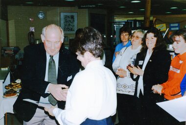
Unions Ballarat
Photograph: John Lenders and others at fundraising tea for Sharon Knight, 9/7/2010
Photograph: John Lenders and others at fundraising tea for Sharon Knight John Lenders served in the legislative assembly and legislative council in the period 1999 to 2014. He served in the cabinet, as Minister of Education and Treasurer in the Bracks and Brumby governments. He was appointed leader of government in the legislative council whilst the ALP were in power. John Lenders retired from politics in 2014. At the time the picture was taken, he was Victorian State Treasurer. There are other people in the photograph who have not been identified. There is a calico bag in the foreground that has the slogan, "Park smart: lock it, remove it or lose it" with a picture of a padlock and a Victorian Government logo. The gathering was to raise funds for Sharon Knight's state election campaign. Knight was successor to Karen Overington. Knight is now the state member for Wendouree. She has a background in health and community sectors, including having managed Lifeline in Ballarat. Photographbtlc, ballarat trades and labour council, ballarat trades hall, park smart, sharon knight, election campaigning, lenders, john, cabinet, politicians - state