Showing 10523 items matching " sections"
-
 Old Colonists' Association of Ballarat Inc.
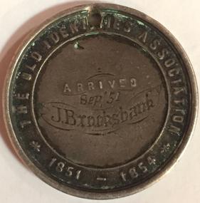
Photograph - Photograph - Colour, John Brooksbank's Old Identities' medal
The Old Identities' Association was a forerunner of the Old Colonists' Association Ballarat. John Brooksbank was a very early arrival to Ballarat in September 1851, which was not long after the discovery of gold at Ballarat. J. Brooksbank lost a dog in 1857 "LOST from the Half Way House, Smythe's Creek Road, a black bloodhound and kangaroo dog. Anyone detaining him after this date will be prosecuted. J. BROOKSBANK" (Ballarat Star, 30 December 1857) Another very early identity in Ballarat, James Oddie, advertised the sale of J. Brooksbank's hotel in 1860: "JAMES ODDIE & CO. have received instructions from the Mortgagees, to sell I by auction at their rooms, Dana street, on Thursday, 20th September, at twelve o'clock, All that desirable properly known as the , Halfway House Hotel, Together with all that piece or parcel of ' land situate in the parish of Cardigan and county of Grenville, containing 34 acres 1 rood 26 ½ perches, part of allotment 1, section 6, of said parish, situated on the Ballarat and Smythesdale road, and recently occupied by Mr J. Brooksbank. The property consists of a spacious stone building one story high, strong and substantially built, the internal fittings and arrangements are neat and complete. The house possesses all requisite accommodation for a respectable country hotel. In addition are stockyards, stables &c, all well and securely fenced. Terms at Sale. (Ballarat Star, 20 September 1860) Four years later Brookbank was selling his hotel in Lyons Street Ballarat: "RARE OPPORTUNITY.-FOR SALE the BLACK BULL HOTEL, Lyons street. The proprietor of the above hotel being about entering into another line of business, begs to call the attention of parties looking for a safe and profitable investment, the above having undergone thorough repairs, and is now in good working order and doing a fair share of business. The conditions will, be half cash, balance six, nine, and twelve months. Apply, J. Brooksbank, proprietor, on the premises. (Ballarat Star, 22 October 1864)Colour photograph of a sterling silver medal relating to The Old Identities' Association 1851-1854. The medallion, belonging to John Brooksbank, has a drilled hole at the top suggesting it was worn by the owner at some stage in its life. The medal has been engraved: Arrived "Sep 51 J. Brooksbankold identities association, old colonists' association ballarat, c.a. welch, silversmith, numismatics, j. brooksbank, medal -
 Old Colonists' Association of Ballarat Inc.
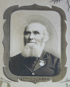
Photograph - Photograph - Black and White, John Brooksbank
The Old Identities' Association was a forerunner of the Old Colonists' Association Ballarat. John Brooksbank was a very early arrival to Ballarat in September 1851, which was not long after the discovery of gold at Ballarat. J. Brooksbank lost a dog in 1857 "LOST from the Half Way House, Smythe's Creek Road, a black bloodhound and kangaroo dog. Anyone detaining him after this date will be prosecuted. J. BROOKSBANK" (Ballarat Star, 30 December 1857) Another very early identity in Ballarat, James Oddie, advertised the sale of J. Brooksbank's hotel in 1860: "JAMES ODDIE & CO. have received instructions from the Mortgagees, to sell I by auction at their rooms, Dana street, on Thursday, 20th September, at twelve o'clock, All that desirable properly known as the , Halfway House Hotel, Together with all that piece or parcel of ' land situate in the parish of Cardigan and county of Grenville, containing 34 acres 1 rood 26 ½ perches, part of allotment 1, section 6, of said parish, situated on the Ballarat and Smythesdale road, and recently occupied by Mr J. Brooksbank. The property consists of a spacious stone building one story high, strong and substantially built, the internal fittings and arrangements are neat and complete. The house possesses all requisite accommodation for a respectable country hotel. In addition are stockyards, stables &c, all well and securely fenced. Terms at Sale. (Ballarat Star, 20 September 1860) Four years later Brookbank was selling his hotel in Lyons Street Ballarat: "RARE OPPORTUNITY.-FOR SALE the BLACK BULL HOTEL, Lyons street. The proprietor of the above hotel being about entering into another line of business, begs to call the attention of parties looking for a safe and profitable investment, the above having undergone thorough repairs, and is now in good working order and doing a fair share of business. The conditions will, be half cash, balance six, nine, and twelve months. Apply, J. Brooksbank, proprietor, on the premises. (Ballarat Star, 22 October 1864)Photographic portrait of John Brooksbank from a photographic montage held by the Ballarat Old Colonists' Association.john brooksbank, ballarat old colonists' association, ballarat old colonists' club, old colonists' association -
 Kew Historical Society Inc
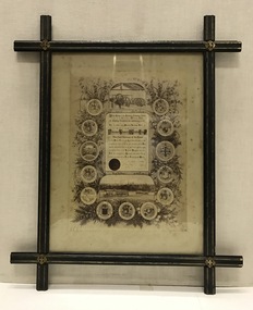
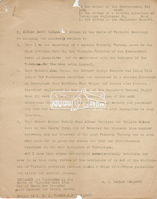
Certificate, Melbourne Tramways Trust, Framed Testimonial to Alderman Thomas O'Grady J.P. from the Melbourne Tramways Trust, 5 February 1886
The recipient of the testimonial, Thomas O’Grady (1824-90) had migrated to Melbourne in 1854, practising the trades of building and contracting. The Australian Dictionary of Biography records that he became a Councillor of the City of Melbourne in 1868. It lists one of his major achievements as the construction ‘with Leggett & Noonan [of] the fifty-six-mile (90 km) railway from Essendon to Seymour’. He was chairman of the Tramways Trust from its formation in 1884. His obituary in the Melbourne Herald (29 Apr 1890) reported: "DEATH OF ALDERMAN THOMAS O'GRADY. Today we have the sad duty of recording the death of two old colonists, who for many years, havo occupied very, prominent positions in building, commercial and municipal circles. The first of these is Alderman Thomas O'Grady, who died last night at his residence in Carlton. Mr O'Grady has been ill for some time, and at one period his death was expected any moment. Then he rallied, and strong hopes of his recovery were entertained; but he had a relapse, and expired as stated. The deceased gentleman was one of the oldest members of the City Council, in which he has held the various positions of Councillor, Alderman and Mayor. At the time of his death he sat as alderman for Victoria Ward. Mr O'Grady also at one time represented the City Council on the Harbor Trust, and was chairman of that body. He has been the council's representative on the Tramway Trust and was chairman of that body for some considerable time." As late as 1951, the Advocate (11 Oct 1951) stated that: "To Alderman Thomas O'Grady, Lord Mayor of Melbourne in 1872-3, is due the credit of the successful inauguration of Hospital Sunday. Alderman O'Grady was the first Catholic Lord Mayor of the city. He was elected a councillor for Smith Ward in 1868, and an alderman in 1869. In private life he was an extensive contractor, being a member of the firm of O'Grady, Leggett and Noonan, the contractors for the first section of the Northeastern Railways (between Melbourne and Seymour)."This is a unique civic document, illustrating the life and contribution of Thomas O’Grady (1824-90), Melbourne City Councillor and first Chairman of the Melbourne Tramways Trust. It is historically significant in its recording of the development of Melbourne's public transport system. The design of the certificate and particularly the ebonised frame are artistically and aesthetically significant.An illustrated testimonial presented to the first Chairman of the Melbourne Tramways Trust in 1886. The Testimonial is encased in an ebonized frame of the period. It includes the coat-of-arms of 12 cities, corporations, boroughs and towns, including that of Kew. At the head of the testimonial the engines used to drive the cable systems are illustrated. At the foot of the testimonial there is a picture of two cable trams.The testimonial reads: ‘At the meeting of the Melbourne Tramways Trust held on the Fifth Day of February 1886, the following resolution was unanimously carried. That the thanks of the Melbourne Tramways Trust are due and are hereby accorded to Alderman Thomas O’Grady Hon. JP, the first Chairman of the Trust for the ability, courtesy and impartiality with which he has discharged his duties during the past two years, and the Trust heartily congratulates him on the successful opening during his term of office of the Richmond Tramway (the first Cable line constructed in Australia) and tenders him its earnest wishes for his future prosperity and welfare.’ melbourne tramways trust, thomas o’grady (1824-90), cable trams, lord mayors of melbourne -
 Vision Australia
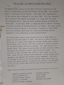
Document - Image, 1934 - 1954 - 50 Years of Talking Book Service, 1984
The Talking Book Library of the Royal Victorian Institute for the Blind is celebrating its 50th anniversary during 1984. This service began in 1934 with 78 rpm records. These were later superceded by 33rpm records which remained in use until 1960. The first cassettes were imported from England and weighed 7 lb. along with the player which weighed 28 lb. These 18 track cassettes usually contained one whole book. In the early 1970's a change was made to smaller cassettes containing 12 hours of recorded material on 6 tracks. The latest system currently being introduced is the Library of Congress 4 Track System utilising cassettes which play for 6 hours and machinery which is adaptable to the conventional 2 track system cassette. The Talking Book Library today provides services to 2500 readers as opposed to only 500 in 1964. The service is free of charge to anyone who is visually handicapped and includes talking books, talking book machines, mail service, servicing of machines at regular intervals and any modifications that may be required. Over 1600 cassettes are handled daily. The library currently holds over 3500 individual titles. Catalogues are available in print, audio and braille format. Once selection is made, borrowers may receive at least 3 books at any one time. Other services include current magazines, foreign language books, newspapers and magazines and regional country newspapers. Many books are recorded at the R.V.I.B. by our volunteer readers while others are bought from similar agencies in Australia and overseas. The department of the R.V.I.B. relies almost entirely on voluntary donations from the public. Other services provided by the Royal Victorian Institute for the Blind Community Resources Section, Aids & Equipment Shop, Tertiary Resource Service, Industrial Department, Retired Personnel Allowance, Children's Services, Social Services, Housing Loans, Vocational Development1 digital image of typewritten pageroyal victorian institute for the blind, talking books -
 The Beechworth Burke Museum Research Collection
Card (Series) - Index Card, George Tibbits, Camp Street, Beechworth, 1976
George Tibbits, University of Melbourne. Faculty of Architecture, Building and Town & Regional PlanningIndex system that support the research for Beechworth : historical reconstruction / [by] George Tibbits ... [et al]Arranged by street names of BeechworthEach index card includes: street name and number of property, image of property, allotment and section number, property owners and dates of ownership, description of the property according to rate records, property floor plan with dimensions.beechworth, george tibbitsbeechworth, george tibbits -
 Tarnagulla History Archive
Photograph of Flour Mill complex, Tarnagulla, Flour Mill complex, Tarnagulla, circa 1882-1920
Murray Comrie Collection. Information written by Murray Comrie: A meeting was called at the Golden Age Hotel on 11th June 1868 when it was resolved to build a flour mill. Thomas Comrie was the proprietor and was responsible for the Mill being built. Tenders were called by H.C. Bristol, in the Tarnagulla Courier of January 10, 1874, for the erection of the mill. Building of the Mill commenced in 1874. Pipes were laid to Company's Dam to obtain water for the Mill's boilers. Steam was got up for the first time on 30th March, 1882. A boiler burst about April 29th. Two men (J.H. Smith and W. Hargreaves) died as a result and two others were seriously injured. The mill commenced operations on 13th June 1882 with Mr. W. Fitzgerald as manager. The Mill operated with grinding stones until 1899 when new rollers and a considerable amount of new equipment was installed, including a new, more powerful engine to drive the Mill. In January 1901, 6,000 bags of wheat were received weekly and it was a common sight to see the streets lined with wagons. In 1913, 15,000 bags of wheat were bought at three shillings and four pence per bushell. In January 1914, wheat came in at the rate of 1500 bags a day with 20,000 bags in storage. Thomas Comrie died on 4th August 1910. The Mill was carried on by his executors, then closed for a short period prior to being sold in September 1918 to a Mr. O. Albert of Talbot. Albert operated the Mill for a few years but during the 1920s it was closed down and then pulled down. It was later re-erected at Mildura where it operated for many years. The far left section of the complex was originally John Pierce's Southern Cross General Store, a wholesale grocer and spirit merchant. It was put up for sale after Pierce's death in 1871, and later incorporated into the Mill complex. This is a poor copy of an older original. Copy probably made by Murray Comrie in the 1960s. Monochrome photograph of men, horses and a wagon outside the Flour Mill complex formerly situated on the south east corner of King Street and Commercial Road in Tarnagulla. At far left the Methodist church is partially visible in the background. At far right is part of the Mill's storage shed. Same image as THA-2019.0211Written on reverse: 'M. Comrie'tarnagulla, commerce, agriculture, food production, mill, milling, horses, transport, buildings, commercial road, main street -
 Tarnagulla History Archive
Photograph of Flour Mill complex, Tarnagulla, Flour Mill complex, Tarnagulla, circa 1882-1920
Murray Comrie Collection. Information written by Murray Comrie: A meeting was called at the Golden Age Hotel on 11th June 1868 when it was resolved to build a flour mill. Thomas Comrie was the proprietor and was responsible for the Mill being built. Tenders were called by H.C. Bristol, in the Tarnagulla Courier of January 10, 1874, for the erection of the mill. Building of the Mill commenced in 1874. Pipes were laid to Company's Dam to obtain water for the Mill's boilers. Steam was got up for the first time on 30th March, 1882. A boiler burst about April 29th. Two men (J.H. Smith and W. Hargreaves) died as a result and two others were seriously injured. The mill commenced operations on 13th June 1882 with Mr. W. Fitzgerald as manager. The Mill operated with grinding stones until 1899 when new rollers and a considerable amount of new equipment was installed, including a new, more powerful engine to drive the Mill. In January 1901, 6,000 bags of wheat were received weekly and it was a common sight to see the streets lined with wagons. In 1913, 15,000 bags of wheat were bought at three shillings and four pence per bushell. In January 1914, wheat came in at the rate of 1500 bags a day with 20,000 bags in storage. Thomas Comrie died on 4th August 1910. The Mill was carried on by his executors, then closed for a short period prior to being sold in September 1918 to a Mr. O. Albert of Talbot. Albert operated the Mill for a few years but during the 1920s it was closed down and then pulled down. It was later re-erected at Mildura where it operated for many years. The far left section of the complex was originally John Pierce's Southern Cross General Store, a wholesale grocer and spirit merchant. It was put up for sale after Pierce's death in 1871, and later incorporated into the Mill complex. This is a reasonable copy of an older original. Copy probably made by Murray Comrie in the 1960s. Monochrome photograph of men, horses and a wagon outside the Flour Mill complex formerly situated on the south east corner of King Street and Commercial Road in Tarnagulla. At far left the Methodist church is partially visible in the background. At far right is part of the Mill's storage shed. Same image as THA-2019.0048Written on reverse: 'M. Comrie'tarnagulla, commerce, agriculture, food production, mill, milling, horses, transport, buildings, commercial road, main street -
 Melbourne Legacy
Photograph, Troopship 1917, 1917
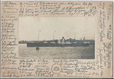
A photo of a troop ship in 1917. This could be the ship Private John Basil McLean travelled to Europe on, and the signatures were his shipmates and the photo was kept as a souvenir of the voyage. Was with other World War 1 memorabilia that has come from Private John Basil McLean, 2nd Reinforcements, 37th Battalion, A.I.F. J.B. McLean (Service No. 13824) was from near Maffra, Victoria and enlisted on 22 January 1916. He embarked on 16 December 1916 on the transport "Medic" for Plymouth, UK, arriving on 18 February 1917. His full war record is available from AWM. He spent time with the Australian Field Artillery (Pack Section). At the end of the war he worked for a year at the A.I.F. Headquarters in London before returning to Australia on the 'Ceramic', arriving Portsea in 1920. Some of the names that are visible are: AA Nelson, Runs, Cyril Barling, Ballantyne, H Robinson, MRH Wright, WG Brabney, NM Hart, HG Worboys, JV Martin, Lardner, JJ Charity, OH Newton, ? Martin, HE Thompson, ?, Bertram May, ? Allam, EJ Burge, LJ Baker, AW Lampard, AS Wickers, Frank H Buff. From Motor Transport: HL Brown, WJ Osborne, EB Kirby, FG Prowse, JW Aspinall, TH Masonette, HR Hadacre. John B Ryder, HW Humphries, David Thomas, VV Pahtonson? Allan Cartlee, PH Doolan, W Riddell, W Rillovison, FR George, HH Syllis, Wm Ford, JBM McLean, ? Gale, F Marsh, CSM McLean, Frank H King, C Pregeau, DW Parsons, Reginald G Edwards, RW Hornabrook. John B Ryder, HW Humphries, Dempsey, HE White, AE Lee, WR Somersby, Phillip L Higgins. Frank H ?, C Prg?, DW Parsons, Reginald G E?, Dick Cushe, and othersA record of a troopship photo being made to commemorate the voyage.Black and white photo of troop transport ship with signatures of passengers on the border.Signatures in black ink around the border. Gold stamp of the photographer: 'Exchange Studios, 47 & 49 Pitt St Sydney'. On the back in ink: '13824 J.B. Mclean A.A.S.C. Reinforcement / Intermediate Base / A.I.F. Abroad / Signatures of A.S.C. Motor Transport and friends on board the A.7 / 17.2.17'world war one, souvenir -
 Eltham District Historical Society Inc
Document, Declaration of Trustees, Eltham Public Hall, Lot 20 Henry Street, Eltham, 18 Mar 1927
Robert David Taylor of Eltham declared he was the Secretary of a certain Friendly Society known as the Hope of Eltham Tent No. 195 Victoria District of the Independent Order of Rechabites; that William John Taylor the Younger, George Knapman and Isaac Hill junior the Purchasers mentioned and described in a certain Indenture of Conveyance from Barnabas Shaw Walker and others also therein described registered in the office of the Registrar General were at the time of the registration of the said Conveyance the trustees of the said Friendly Society and purchased the land and hereditaments described in the Conveyance as such Trustees; and that Edward Samuel McColl, Jack Alfred Harrison and William Wilson were on 31 December 1926 the trustees of the said Friendly Society and as such were entitled to grant and convey the land and hereditaments described in the said Indenture of Conveyance. Originally purchased in 1856 from Thomas Roberts, Yeoman of Little Eltham, for £10 for use by the Wesleyan Chapel, represented by indentured Trustees, Rev. Barnabas Shaw Walker, Minister of the Pentridge Circuit, Francis Thomas, Farmer of Keelbundora, William Harriman, Blacksmith of Nillumbik, Nicholas Rodda, Farmer of Nillumbik, Aaron Grimshaw, Farmer of Greensborough, Joseph Cooper, Gardener of Keelbundora, Peter Dredge, Scholmaster of Jika Jika and Samuel Jeffrey, Farmer of Jika Jika. Lot 20 of Subdivision of Portion 13, Section 4 of the Parish of Nillumbik in the County of Evelyn was located on the southern side of Henry street in Little Eltham North, where the current Our Lady Help of Christians Catholic Church is situated. It became the location of the Eltham Rechabite Hall. In 1893 a new hall was built and further enlarged in 1919. At the commencement of 1922, the property was purchased from the Independent Order of Rechabites with publicly subscribed funds and a new hall built at a cost of £750 and improved road access constructed to reduce the grade, running from Dudley Street to Henry Street. This hall was eventually replaced with the new Shire Offices and Hall built on the corner of Arthur Street and Main Road, which was opened in 1941. Traces the earliest history of the Eltham Public Hall in Henry Street and the various names, occupations and abodes of the Trustees associated with the propertyedward samuel mccoll, eltham public hall, eltham rechabite hall, eltham wesleyan chapel, george knapman, henry street, hope of eltham tent no. 195, isaac hill junior, jack alfred harrison, trustee, victoria district independent order of rechabites, william john taylor the younger, william wilson -
 Melbourne Tram Museum
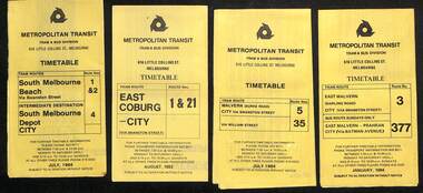
Ephemera - Timetables - Metropolitan Transit - set of 22, Metropolitan Transit Authority (MTA), 1983 and 1984
Timetables - provides information on fare sections and a route map. 1 - Routes 1, 2 & 4 - South Melbourne - City - July 1984 2 - Route 1 & 21 - East Coburg - City August 1983 3 - Route 5 and 35 - Malvern Burke Road - July 1984 4 - Route 3 and 377 - East Malvern (Darling Road) and bus route on Sundays only - Jan. 1984 5 - Route 6, 36 and 7 - Glen Iris - July 1984 6 - Route 8 and 38 - Toorak - June 1984 7 - Route 9 and 14 - Northcote - June 1984 8 - Route 10 & 11, 13 - West Preston - May 1984 9 - Route 15 & 22 - Moreland - July 1983 10 - Route 15 & 16, 53 & 55 - St Kilda Beach - July 1983 11 - Route 19, 20 and 18 (MMTB) - North Coburg - Oct. 1982 12 - Route 42, 23, 44, 45 and 47 - Mont Albert - July 1984 13 - Route 48, 24, 40, 41 and 29 - North Balwyn - Nov. 1983 14 - Route 57, 357, 54, 60, 58 and 50 - West Maribyrnong - bus on Sundays - July 1984 15 - Route 64, 65, 62 and 61 - East Brighton - Jan. 1984 16 - Route 67, 37, and 66 - Carnegie - Jan. 1984 17 - route 70, 71 and 76 - Wattle Park - June 1984 18 - route 75, 74, 76 and 28 - East Burwood - JIan. 1984 19 - route 77, 78 and 79 - Prahran - North Richmond - July 1984 20 - route 82 and 223 - Footscray - Moonee Ponds and bus on Sundays and Saturdays - June 1984 21 - route 88, 14, 89 and 90 - East Preston - July 1983 22 - route 96, 95 and 97 - East Brunswick - July8 1984Yields information about Metropolitan Transit services during the mid 1980s.Set of 22 Metropolitan Transit tram timetables - multifold printed on yellow paper.timetable, metropolitan transit, the met, route 1, route 2, route 4, route 21, route 5, route 35, route 3, route 377, route 6, route 36, route 7, route 8, route 38, route 9, route 14, route 10, route 11, route 13, route 15, route 22, route 16, route 53, route 55, route 19, route 18, route 20, route 42, route 23, route 44, route 45, route 47, route 48, route 24, route 40, route 41, route 29, route 57, route 357, route 54, route 60, route 58, route 50, route 64, route 65, route 62, route 61, route 67, route 37, route 66, route 70, route 71, route 76, route 75, route 74, route 28, route 77, route 78, route 79, route 82, route 223, route 99, route 89, route 90, route 96, route 95, route 97 -
 Bendigo Military Museum
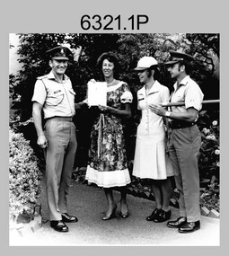
Photograph - Army Survey Regiment – Presentation to Charity Organisation, 1984
These photographs of a presentation to a charity organisation were taken in the grounds of Fortuna Villa, Army Survey Regiment in 1984. SPR Tracy (Parker) Ash was the unit’s Miss Golden North section entrant in the Miss Australia Quest. MAJ Bob Roche, RSM Bob Mason and SPR Parker presented a fundraising cheque to the unidentified representative from the Spastic Society. The the newspaper article is from the Bendigo Advertiser. The following wording is taken from the article: ‘Tracy Parker is a sapper in the Army, and a cartographic technician stationed at Fortuna, Bendigo. Originally from Melbourne, Tracy, 23, is the latest entrant in the Miss Golden North segment of the Miss Australia Quest. The highlight of Tracy’s quest will be an open day at Fortuna, once the magnificent home of Bendigo’s Quartz King, George Lansell. This open day at Fortuna, on Sunday, August 26, between 10 am and 4 pm, will give district residents a rare opportunity of inspecting this magnificent building and its gardens. Tracy said there will be handicrafts, rides, competitions and refreshments available at the open day. The main attraction, apart from the building and gardens, would be a hot air balloon. Admission to the open day would be: Adults $2, children and pensioners $1, family party $5. All proceeds from the open day at Fortuna will go to the Spastic Society. Tracy, like all other Miss Australia candidates work hard for the Spastic Society in fundraising activities. Getting further involved in fundraising, Tracy and her strong committee have organised a 6km fun run for Sunday August 19. Entry forms are available at Bendigo sports stores, and at the end of the fun run will be a barbecue. Apart from her vocation in the Army, and fundraising for the Spastic Society, Tracy Parker has a great love of horses, and associated activities of riding, jumping and showing her horses. Tracy is keen to do well in her fundraising, and with the Australian Army, or more particularly, the ranks of Fortuna behind her, Tracy looks like succeeding.’The first three items are photographs of a presentation to a charity organisation at the Army Survey Regiment, Bendigo in 1984. The fourth item is an article from the Bendigo Advertiser describing Army Survey Regiment’s fund-raising activities. The photographs were printed on photographic paper and are part of the Army Survey Regiment’s Collection. The photographic proof prints were scanned at 600 dpi. Photos .1P and .2P were scanned at 300 dpi. The newspaper article was scanned at 762 dpi. .1) to .3P) - Photo, black & white, 1984, L to R: MAJ Bob Roche, Regional Coordinator Mrs Jan Lamborn, SPR Tracy (Parker) Ash, RSM WO1 Bob Mason. .4) – Bendigo Advertiser newspaper article with photo, black & white, 1984, SPR Tracy (Parker) Ash. .1P to .2P – ‘Presentation of Certificate of Appreciation from Spastic Society. Presented by Regional Coordinator Mrs Jan Lamborn to MAJ Roche, SPR Tracy Ash (entrant in Miss Australia Quest (1984) and WO1 Mason.' .3P – No personnel identified. .4P – SPR Tracy Parker named in newspaper article.royal australian survey corps, rasvy, army survey regiment, army svy regt, fortuna, asr -
 Flagstaff Hill Maritime Museum and Village
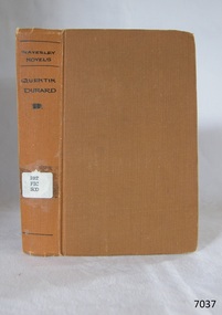
Book, Waverley Novels Vol 32 Quentin Durward
Pattison Collection This item is from the ‘Pattison Collection’, a collection of books and records that was originally owned by the Warrnambool Mechanics’ Institute, which was founded in Warrnambool in 1853. By 1886 the Warrnambool Mechanics’ Institute (WMI) had grown to have a Library, Museum and Fine Arts Gallery, with a collection of “… choice productions of art and valuable specimens in almost every branch and many wonderful national curiosities are now to be seen there, including historic relics of the town and district.” It later included a School of Design. Although it was very well patronised, the lack of financial support led the WMI in 1911 to ask the City Council to take it over. In 1935 Ralph Pattison was appointed as City Librarian to establish and organise the Warrnambool Library as it was then called. When the WMI building was pulled down in 1963 a new civic building was erected on the site and the new Warrnambool Library, on behalf of the City Council, took over all the holdings of the WMI. At this time some of the items were separated and identified as the ‘Pattison Collection’, named after Ralph Pattison. Eventually, the components of the WMI were distributed from the Warrnambool Library to various places, including the Art Gallery, Historical Society and Flagstaff Hill. Later some were even distributed to other regional branches of Corangamite Regional Library and passed to and fro. It is difficult now to trace just where all of the items have ended up. The books at Flagstaff Hill Maritime Village generally display stamps and markings from Pattison as well as a variety of other institutions including the Mechanics’ Institute itself. RALPH ERIC PATTISON Ralph Eric Pattison was born in Rockhampton, Queensland, in 1891. He married Maude Swan from Warrnambool in 1920 and they set up home in Warrnambool. In 1935 Pattison accepted a position as City Librarian for the Warrnambool City Council. His huge challenge was to make a functional library within two rooms of the Mechanics’ Institute. He tirelessly cleaned, cleared and sorted a disarrayed collection of old books, jars of preserved specimens and other items reserved for exhibition in the city’s museum. He developed and updated the library with a wide variety of books for all tastes, including reference books for students; a difficult task to fulfil during the years following the Depression. He converted all of the lower areas of the building into a library, reference room and reading room for members and the public. The books were sorted and stored using a cataloguing and card index system that he had developed himself. He also prepared the upper floor of the building and established the Art Gallery and later the Museum, a place to exhibit the many old relics that had been stored for years for this purpose. One of the treasures he found was a beautiful ancient clock, which he repaired, restored and enjoyed using in his office during the years of his service there. Ralph Pattison was described as “a meticulous gentleman whose punctuality, floorless courtesy and distinctive neat dress were hallmarks of his character, and ‘his’ clock controlled his daily routine and his opening and closing of the library’s large heavy doors to the minute.” Pattison took leave from 1942 to 1945 to serve in the Royal Australian Navy, Volunteer Reserve as Lieutenant. A few years later he converted one of the Museum’s rooms into a Children’s Library, stocking it with suitable books for the younger generation. This was an instant success. In the 1950’s he had the honour of being appointed to the Victorian Library Board and received more inspiration from the monthly conferences in Melbourne. He was sadly retired in 1959 after over 23 years of service, due to the fact that he had gone over the working age of council officers. However, he continued to take a very keen interest in the continual development of the Library until his death in 1969. WARRNAMBOOL PUBLIC LIBRARY The Warrnambool Mechanics’ Institute (WMI) was formed by a voluntary community group in 1863, within six years of Warrnambool’s beginnings, and it’s Reading Room opened in 1854. The WMI operated until 1963, at which time it was one of the oldest Mechanics’ Institutes in Victoria. Mechanics’ Institutes offered important services to the public including libraries, reading rooms and places to display and store collections of all sorts such as curiosities and local historical relics. In 1886 a Museum and Fine Arts Gallery were added to the WMI and by the beginning of the 20th century, there was also a billiards room and a School of Art. By this time all Mechanics’ Institutes in country Victoria had museums attached. Over the years the Warrnambool Mechanics’ Institute Library was also known as the Warrnambool Public Library the Warrnambool Library and the Free Library. Early funding from the government was for the “Free Library”. The inscription in a book “Science of Man” was for the “Warrnambool Public Library”, donated by Joseph Archibald in 1899. Another inscription in the book “Catalogue of Plants Under Cultivation in the Melbourne Botanic Gardens 1 & 2, 1883” was presented to the “Warrnambool Library” and signed by the author W.R. Guilfoyle. In 1903 the Warrnambool Public Library decided to add a Juvenile Department to library and stock it with hundreds of books suitable for youth. In 1905 the Public Library committee decided to update the collection of books and added 100 new novels plus arrangements for the latest novels to be included as soon as they were available in Victoria. In July 1911 the Warrnambool Council took over the management of the Public Library, Art Gallery, Museum and Mechanics’ Institute and planned to double the size of the then-current building. In 1953, when Mr R. Pattison was Public Librarian, the Warrnambool Public Library’s senior section 10,000 of the 13,000 books were fiction. The children’s section offered an additional 3,400 books. The library had the equivalent of one book per head of population and served around 33 per cent of the reading population. The collection of books was made up of around 60 per cent reference and 40 per cent fiction. The library was lending 400 books per day. In 1963 the Warrnambool City Council allocated the site of the Mechanics’ Institute building, which included the Public Library, Museum and Art Gallery, for the new Municipal Offices and the Collections were dispersed until 1971. The Warrnambool Library took over the Mechanics’ Institute Library’s holdings on behalf of the Warrnambool City Council. Since the closure of the Warrnambool Mechanics’ Institute the exact location and composition of the original WMI books and items have become unclear. Other materials have been added to the collection, including items from Terang MI, Warrnambool Court House and Customs House. Many of the books have been identified as the Pattison Collection, named after the Librarian who catalogued and numbered the books during his time as Warrnambool Public Librarian in the time before the Mechanics’ Institute closed. It seems that when Warrnambool became part of the Corangamite Regional Library some of the books and materials went to its head office in Colac and then back to Warrnambool where they were stored at the Art Gallery for quite some time. Some then went to the Warrnambool Historical Society, some stayed at the Art Gallery and some were moved to Flagstaff Hill Maritime Village. The various stamps and labels on the books held at Flagstaff Hill show the variety of the collection’s distribution and origin. The books in the collection at Flagstaff Hill Maritime Village date from the 1850s to the late 1950s and include rare and valuable volumes. Many of the books are part of the “Pattison Collection” after the Warrnambool’s Public Librarian, Mr R. Pattison. WARRNAMBOOL PUBLIC LIBRARY The Warrnambool Mechanics’ Institute (WMI) was formed by a voluntary community group in 1863, within six years of Warrnambool’s beginnings, and it’s Reading Room opened in 1854. The WMI operated until 1963, at which time it was one of the oldest Mechanics’ Institutes in Victoria. Mechanics’ Institutes offered important services to the public including libraries, reading rooms and places to display and store collections of all sorts such as curiosities and local historical relics. In 1886 a Museum and Fine Arts Gallery were added to the WMI and by the beginning of the 20th century, there was also a billiards room and a School of Art. By this time all Mechanics’ Institutes in country Victoria had museums attached. Over the years the Warrnambool Mechanics’ Institute Library was also known as the Warrnambool Public Library the Warrnambool Library and the Free Library. Early funding from the government was for the “Free Library”. The inscription in a book “Science of Man” was for the “Warrnambool Public Library”, donated by Joseph Archibald in 1899. Another inscription in the book “Catalogue of Plants Under Cultivation in the Melbourne Botanic Gardens 1 & 2, 1883” was presented to the “Warrnambool Library” and signed by the author W.R. Guilfoyle. In 1903 the Warrnambool Public Library decided to add a Juvenile Department to library and stock it with hundreds of books suitable for youth. In 1905 the Public Library committee decided to update the collection of books and added 100 new novels plus arrangements for the latest novels to be included as soon as they were available in Victoria. In July 1911 the Warrnambool Council took over the management of the Public Library, Art Gallery, Museum and Mechanics’ Institute and planned to double the size of the then-current building. In 1953, when Mr R. Pattison was Public Librarian, the Warrnambool Public Library’s senior section 10,000 of the 13,000 books were fiction. The children’s section offered an additional 3,400 books. The library had the equivalent of one book per head of population and served around 33 per cent of the reading population. The collection of books was made up of around 60 per cent reference and 40 per cent fiction. The library was lending 400 books per day. In 1963 the Warrnambool City Council allocated the site of the Mechanics’ Institute building, which included the Public Library, Museum and Art Gallery, for the new Municipal Offices and the Collections were dispersed until 1971. The Warrnambool Library took over the Mechanics’ Institute Library’s holdings on behalf of the Warrnambool City Council. Since the closure of the Warrnambool Mechanics’ Institute the exact location and composition of the original WMI books and items have become unclear. Other materials have been added to the collection, including items from Terang MI, Warrnambool Court House and Customs House. Many of the books have been identified as the Pattison Collection, named after the Librarian who catalogued and numbered the books during his time as Warrnambool Public Librarian in the time before the Mechanics’ Institute closed. It seems that when Warrnambool became part of the Corangamite Regional Library some of the books and materials went to its head office in Colac and then back to Warrnambool where they were stored at the Art Gallery for quite some time. Some then went to the Warrnambool Historical Society, some stayed at the Art Gallery and some were moved to Flagstaff Hill Maritime Village. The various stamps and labels on the books held at Flagstaff Hill show the variety of the collection’s distribution and origin. The books in the collection at Flagstaff Hill Maritime Village date from the 1850s to the late 1950s and include rare and valuable volumes. Many of the books are part of the “Pattison Collection” after the Warrnambool’s Public Librarian, Mr R. Pattison. WARRNAMBOOL PUBLIC LIBRARY The Warrnambool Mechanics’ Institute (WMI) was formed by a voluntary community group in 1863, within six years of Warrnambool’s beginnings, and it’s Reading Room opened in 1854. The WMI operated until 1963, at which time it was one of the oldest Mechanics’ Institutes in Victoria. Mechanics’ Institutes offered important services to the public including libraries, reading rooms and places to display and store collections of all sorts such as curiosities and local historical relics. In 1886 a Museum and Fine Arts Gallery were added to the WMI and by the beginning of the 20th century, there was also a billiards room and a School of Art. By this time all Mechanics’ Institutes in country Victoria had museums attached. Over the years the Warrnambool Mechanics’ Institute Library was also known as the Warrnambool Public Library the Warrnambool Library and the Free Library. Early funding from the government was for the “Free Library”. The inscription in a book “Science of Man” was for the “Warrnambool Public Library”, donated by Joseph Archibald in 1899. Another inscription in the book “Catalogue of Plants Under Cultivation in the Melbourne Botanic Gardens 1 & 2, 1883” was presented to the “Warrnambool Library” and signed by the author W.R. Guilfoyle. In 1903 the Warrnambool Public Library decided to add a Juvenile Department to library and stock it with hundreds of books suitable for youth. In 1905 the Public Library committee decided to update the collection of books and added 100 new novels plus arrangements for the latest novels to be included as soon as they were available in Victoria. In July 1911 the Warrnambool Council took over the management of the Public Library, Art Gallery, Museum and Mechanics’ Institute and planned to double the size of the then-current building. In 1953, when Mr R. Pattison was Public Librarian, the Warrnambool Public Library’s senior section 10,000 of the 13,000 books were fiction. The children’s section offered an additional 3,400 books. The library had the equivalent of one book per head of population and served around 33 per cent of the reading population. The collection of books was made up of around 60 per cent reference and 40 per cent fiction. The library was lending 400 books per day. In 1963 the Warrnambool City Council allocated the site of the Mechanics’ Institute building, which included the Public Library, Museum and Art Gallery, for the new Municipal Offices and the Collections were dispersed until 1971. The Warrnambool Library took over the Mechanics’ Institute Library’s holdings on behalf of the Warrnambool City Council. Since the closure of the Warrnambool Mechanics’ Institute the exact location and composition of the original WMI books and items have become unclear. Other materials have been added to the collection, including items from Terang MI, Warrnambool Court House and Customs House. Many of the books have been identified as the Pattison Collection, named after the Librarian who catalogued and numbered the books during his time as Warrnambool Public Librarian in the time before the Mechanics’ Institute closed. It seems that when Warrnambool became part of the Corangamite Regional Library some of the books and materials went to its head office in Colac and then back to Warrnambool where they were stored at the Art Gallery for quite some time. Some then went to the Warrnambool Historical Society, some stayed at the Art Gallery and some were moved to Flagstaff Hill Maritime Village. The various stamps and labels on the books held at Flagstaff Hill show the variety of the collection’s distribution and origin. The books in the collection at Flagstaff Hill Maritime Village date from the 1850s to the late 1950s and include rare and valuable volumes. Many of the books are part of the “Pattison Collection” after the Warrnambool’s Public Librarian, Mr R. Pattison. WARRNAMBOOL PUBLIC LIBRARY The Warrnambool Mechanics’ Institute (WMI) was formed by a voluntary community group in 1863, within six years of Warrnambool’s beginnings, and it’s Reading Room opened in 1854. The WMI operated until 1963, at which time it was one of the oldest Mechanics’ Institutes in Victoria. Mechanics’ Institutes offered important services to the public including libraries, reading rooms and places to display and store collections of all sorts such as curiosities and local historical relics. In 1886 a Museum and Fine Arts Gallery were added to the WMI and by the beginning of the 20th century, there was also a billiards room and a School of Art. By this time all Mechanics’ Institutes in country Victoria had museums attached. Over the years the Warrnambool Mechanics’ Institute Library was also known as the Warrnambool Public Library the Warrnambool Library and the Free Library. Early funding from the government was for the “Free Library”. The inscription in a book “Science of Man” was for the “Warrnambool Public Library”, donated by Joseph Archibald in 1899. Another inscription in the book “Catalogue of Plants Under Cultivation in the Melbourne Botanic Gardens 1 & 2, 1883” was presented to the “Warrnambool Library” and signed by the author W.R. Guilfoyle. In 1903 the Warrnambool Public Library decided to add a Juvenile Department to library and stock it with hundreds of books suitable for youth. In 1905 the Public Library committee decided to update the collection of books and added 100 new novels plus arrangements for the latest novels to be included as soon as they were available in Victoria. In July 1911 the Warrnambool Council took over the management of the Public Library, Art Gallery, Museum and Mechanics’ Institute and planned to double the size of the then-current building. In 1953, when Mr R. Pattison was Public Librarian, the Warrnambool Public Library’s senior section 10,000 of the 13,000 books were fiction. The children’s section offered an additional 3,400 books. The library had the equivalent of one book per head of population and served around 33 per cent of the reading population. The collection of books was made up of around 60 per cent reference and 40 per cent fiction. The library was lending 400 books per day. In 1963 the Warrnambool City Council allocated the site of the Mechanics’ Institute building, which included the Public Library, Museum and Art Gallery, for the new Municipal Offices and the Collections were dispersed until 1971. The Warrnambool Library took over the Mechanics’ Institute Library’s holdings on behalf of the Warrnambool City Council. Since the closure of the Warrnambool Mechanics’ Institute the exact location and composition of the original WMI books and items have become unclear. Other materials have been added to the collection, including items from Terang MI, Warrnambool Court House and Customs House. Many of the books have been identified as the Pattison Collection, named after the Librarian who catalogued and numbered the books during his time as Warrnambool Public Librarian in the time before the Mechanics’ Institute closed. It seems that when Warrnambool became part of the Corangamite Regional Library some of the books and materials went to its head office in Colac and then back to Warrnambool where they were stored at the Art Gallery for quite some time. Some then went to the Warrnambool Historical Society, some stayed at the Art Gallery and some were moved to Flagstaff Hill Maritime Village. The various stamps and labels on the books held at Flagstaff Hill show the variety of the collection’s distribution and origin. The books in the collection at Flagstaff Hill Maritime Village date from the 1850s to the late 1950s and include rare and valuable volumes. Many of the books are part of the “Pattison Collection” after the Warrnambool’s Public Librarian, Mr R. Pattison. WARRNAMBOOL PUBLIC LIBRARY The Warrnambool Mechanics’ Institute (WMI) was formed by a voluntary community group in 1863, within six years of Warrnambool’s beginnings, and it’s Reading Room opened in 1854. The WMI operated until 1963, at which time it was one of the oldest Mechanics’ Institutes in Victoria. Mechanics’ Institutes offered important services to the public including libraries, reading rooms and places to display and store collections of all sorts such as curiosities and local historical relics. In 1886 a Museum and Fine Arts Gallery were added to the WMI and by the beginning of the 20th century, there was also a billiards room and a School of Art. By this time all Mechanics’ Institutes in country Victoria had museums attached. Over the years the Warrnambool Mechanics’ Institute Library was also known as the Warrnambool Public Library the Warrnambool Library and the Free Library. Early funding from the government was for the “Free Library”. The inscription in a book “Science of Man” was for the “Warrnambool Public Library”, donated by Joseph Archibald in 1899. Another inscription in the book “Catalogue of Plants Under Cultivation in the Melbourne Botanic Gardens 1 & 2, 1883” was presented to the “Warrnambool Library” and signed by the author W.R. Guilfoyle. In 1903 the Warrnambool Public Library decided to add a Juvenile Department to library and stock it with hundreds of books suitable for youth. In 1905 the Public Library committee decided to update the collection of books and added 100 new novels plus arrangements for the latest novels to be included as soon as they were available in Victoria. In July 1911 the Warrnambool Council took over the management of the Public Library, Art Gallery, Museum and Mechanics’ Institute and planned to double the size of the then-current building. In 1953, when Mr R. Pattison was Public Librarian, the Warrnambool Public Library’s senior section 10,000 of the 13,000 books were fiction. The children’s section offered an additional 3,400 books. The library had the equivalent of one book per head of population and served around 33 per cent of the reading population. The collection of books was made up of around 60 per cent reference and 40 per cent fiction. The library was lending 400 books per day. In 1963 the Warrnambool City Council allocated the site of the Mechanics’ Institute building, which included the Public Library, Museum and Art Gallery, for the new Municipal Offices and the Collections were dispersed until 1971. The Warrnambool Library took over the Mechanics’ Institute Library’s holdings on behalf of the Warrnambool City Council. Since the closure of the Warrnambool Mechanics’ Institute the exact location and composition of the original WMI books and items have become unclear. Other materials have been added to the collection, including items from Terang MI, Warrnambool Court House and Customs House. Many of the books have been identified as the Pattison Collection, named after the Librarian who catalogued and numbered the books during his time as Warrnambool Public Librarian in the time before the Mechanics’ Institute closed. It seems that when Warrnambool became part of the Corangamite Regional Library some of the books and materials went to its head office in Colac and then back to Warrnambool where they were stored at the Art Gallery for quite some time. Some then went to the Warrnambool Historical Society, some stayed at the Art Gallery and some were moved to Flagstaff Hill Maritime Village. The various stamps and labels on the books held at Flagstaff Hill show the variety of the collection’s distribution and origin. The books in the collection at Flagstaff Hill Maritime Village date from the 1850s to the late 1950s and include rare and valuable volumes. Many of the books are part of the “Pattison Collection” after the Warrnambool’s Public Librarian, Mr R. Pattison. The Pattison Collection, along with other items at Flagstaff Hill Maritime Village, was originally part of the Warrnambool Mechanics' Institute’s collection. The Warrnambool Mechanics’ Institute Collection is primarily significant in its totality, rather than for the individual objects it contains. Its contents are highly representative of the development of Mechanics' Institute libraries across Australia, particularly Victoria. A diversity of publications and themes has been amassed, and these provide clues to our understanding of the nature of and changes in the reading habits of Victorians from the 1850s to the middle of the 20th century. The collection also highlights the Warrnambool community’s commitment to the Mechanics’ Institute, reading, literacy and learning in the regions, and proves that access to knowledge was not impeded by distance. These items help to provide a more complete picture of our community’s ideals and aspirations. The Warrnambool Mechanics Institute book collection has historical and social significance for its strong association with the Mechanics Institute movement and the important role it played in the intellectual, cultural and social development of people throughout the latter part of the nineteenth century and the early twentieth century. The collection of books is a rare example of an early lending library and its significance is enhanced by the survival of an original collection of many volumes. The Warrnambool Mechanics' Institute’s publication collection is of both local and state significance. The Warrnambool Mechanics' Institute Collection is primarily significant in its totality, rather than for the individual objects it contains. Its contents are highly representative of the development of Mechanics' Institute libraries across Australia, particularly Victoria. A diversity of publications and themes has been amassed, and these provide clues to our understanding of the nature of and changes in the reading habits of Victorians from the 1850s to the middle of the 20th century. The collection also highlights the Warrnambool community’s commitment to the Mechanics’ Institute, and to reading, literacy and learning in the regions, and proves that access to knowledge was not impeded by distance. These items help to provide a more complete picture of our community’s ideals and aspirations. As with many Mechanics' Institutes in Australia, the one which operated in Warrnambool was established and overseen for many years by key individuals associated with the development of the city itself. The WMI publication collection is historically significant because of its association with local people, places and the key historical themes in the development of Warrnambool of rural development, industry, farming, education, and community. The collection documents and illustrates the changing interests, focus and tastes of Victorians, especially those in regional cities. Generally the individual items in the collection are not particularly rare, as examples of all probably exist in other public collections in Victoria. It is primarily because there are so very few surviving Mechanics' Institute collections in Victoria, which lends this overall collection its significance. Many items in the WMI Collection have the potential to support further research, both as individual objects and through the collection in its entirety. This material is significant for its ability to assist in the interpretation of the history of the area and adds to the general understanding of the development of the township. Many components of the WMI publication collection complement and reinforce the Flagstaff Hill Maritime Museum Collection, the Warrnambool Art Gallery Collection, and that in the Warrnambool Historical Society, and also contribute to a clearer understanding of the original Warrnambool Mechanics' Institute collections. This will greatly enhance the appreciation of the few surviving Mechanics' Institute collections across Victoria, and also in New South Wales. The similarities and differences between the small number of collections that have survived can provide further insights into how the people of Victoria in general, and Warrnambool in particular, constructed a civic culture of adult learning to foster an informed citizenry. The Warrnambool Mechanics' Institute publication collection is of both local and state significance Waverley Novels Vol 32 Quentin Durward Author: Sir Walter Scott Publisher: Fisher Son & Co Date: 1838The label on the spine with typed text PAT FIC SCO Pastedown front endpaper has a sticker from Warrnambool Public Library covered by a sticker from Corangamite Regional Library Servicewarrnambool, shipwrecked-coast, flagstaff-hill, flagstaff-hill-maritime-museum, maritime-museum, shipwreck-coast, flagstaff-hill-maritime-village, shipwrecked-artefact, book, waverley novels vol 32 quentin durward, sir walter scott, warrnambool mechanics’ institute, pattison collection, warrnambool library, ralph eric pattison, corangamite regional library service, warrnambool city librarian, mechanics’ institute library, victorian library board, warrnambool books and records, warrnambool children’s library -
 Eltham District Historical Society Inc
Document - Certificate of Title, Landata, Vol. 4930 Fol. 985900, Crown Portion 15 Section 5, Parish of Nillumbik, County of Evelyn, 1925
(Cancelled) Certificate of Title originally issued for Crown Portion 15, Section 5 to Robert David Taylor, of Eltham, County of Evelyn, Farmer, 13 March 1925. It is with this title that the land allotment was subdivided into 48 lots. The title shows the issuance to Robert David Taylor with encumbrance placed upon it by immediate former owner, Hugh Patrick Keogh, a former member for Gippsland and Melbourne Real Estate Agent. Following Taylor's death in 1934 the title passes to his Executors, sons Robert David Taylor of Bible Street, Eltham and William McLelland Vance Taylor of Northcote. The property is then sold to Frank Stokes who develops the Stokes Orchard. Compulsory acquisitions by the Melbourne Metropolitan Board of Works and State Electricity Commission show provisions of easemenst for town water supply and high voltage power transmission lines. Subsequent lots are then sold off with the development of the Stokes Orchard Estate residential development in the mid to late 1970s. A History of the Development of Crown Allotment 15, Section 5, Parish of Nillumbik – Stokes Orchard Crown Allotment 15, Section 5, Parish of Nillumbik (CA15) is a square allotment of 158 acres or approximately a quarter of a square mile. It lies just beyond the eastern end of Pitt Street, south of Nyora Road to the northern end of Eucalyptus Road and extends east from Eucalyptus Road to Reynolds Road. The topography of CA15 is generally steep, sloping up to a hill near the centre of the land, the ridgeline passing through the properties along the southern side of Diosma Road. Eucalyptus Road is a straight north-south road with its northern end at the north west corner of CA15. Until the end of the 1970s this road was an un-named Government Road and was largely not open to traffic. With residential development in the 1970s the road was constructed, and the council allocated the name obviously in recognition of the predominant species of the local bushland. CA15 was purchased from the Crown by George D’Arley Boursiquot, a prominent Melbourne printer, on 28th October 1852. On November 23, 1922, former Member for Gippsland and Melbourne Real Estate Agent, Hubert Patrick Keogh purchased the allotment then sold it March 13, 1925, to local farmer, Robert David Taylor, a former Shire of Eltham Councillor (1911-1920) and Shire President (1919). Taylor had extensive land holdings stretching west towards Bible Street and Main Road. The Taylor home was situated at the top of the hill in Bible Street at present day 82 Bible Street. At the time of Taylor’s purchase in 1925, CA15 was subdivided into 48 lots that could be described as small rural properties or large residential lots. A typical lot size was one hectare or 2.5 acres. The subdivision created two roads, Nyora Road, and Diosma Road, each following an irregular alignment between Eucalyptus and Reynolds Roads. However, the lots were not sold off separately nor were the roads constructed. The land effectively remained as one parcel for many further years. Robert David Taylor died November 30, 1934, and probate was granted to his son of the same name, Robert David Taylor of Bible Street, Salesman and William McLelland Vance Taylor of 73 Emmeline Street, Northcote, Clerk, with the transfer of the land into their names on July 8, 1935. Frank Stokes worked as a qualified accountant at Kennons leather factory in Burnley, while living at 1 Thomas Street, Mitcham. He suffered from migraines and wanted to return to working the land (he had previously worked on farms and orchards since coming to Australia from England in 1926, both in WA and Vic.). He first travelled to the district by train in July 1942 to find land with the intention to establish an orchard. By chance he met Arthur Bird of Bird Orchard (bounded by Pitt Street, Eucalyptus Road, and Wattle Grove) and they got talking over their common interest. Arthur put Frank up for the night and pointed out the land, 158 acres- part of the Taylor Estate- £900, Crown Allotment 15, Section 5, Parish of Nillumbik (CA15) somewhat diagonally opposite Bird Orchard. Stokes applied through the Riverina Agency to purchase the land who in turn applied for permission from Canberra to sell as there was a new government regulation introduced during the Second World War banning land sales except for immediate production. Stokes obtained a loan on his Mitcham house of £600 @ 5% and paid £450 deposit with quarterly payments of £15 spread over 5 years. Stokes was assisted and advised by Arthur Bird who farmed the neighbouring orchard. In early 1943 Stokes took possession and would catch the train out to Eltham on Fridays after work and began building a hut on the corner of Nyora Road and the Government Road (Eucalyptus Road) for shelter and to lock up tools. He established an orchard on the central western part of the land through the centre of which ran a natural waterway (part of the present-day linear park) and was able to pay a neighbour (Hawkins) to help with clearing and fencing 25 acres, and with a horse and single furrowed plough, planted approximately 2,500 fruit trees - cherries, peaches, plums, almonds, pears, apricots and lemons as well as a few apples and oranges; a massive task. Aerial photographs from the 1940s through to the 1990s clearly show the orchard with most of the larger CA15 site remaining as natural bushland. A huge problem was hares and rabbits eating all the new buds off the tiny trees. As well as laying poison he painted the trees with a mixture of cow manure and lime, often working by moonlight. Procurement of wire and wire netting was difficult because of the war but after much effort he obtained a permit from the Agricultural Department for supplies in March 1944. In February 1945 Stokes applied for a permit to build a “packing shed” as no house building was allowed. It was to be 33 feet x 21 feet and cost £312. It was constructed mostly from second-hand materials, which were hard to obtain, especially iron for roofing. Stokes finished work at Kennons on October 31, 1945, and in March 1946 he sold the family home at Mitcham for £1,230 plus £170 for furniture. On May 15, 1946, title to the CA15 property was issued to Frank Howard Alfred Stokes, Orchardist and Gladys Ethel Stokes, Married Woman, both of Pitt Street, Eltham. The family of five then moved into the very unfinished “packing shed” at Eltham, which was a struggle to weatherproof. Eventually rooms were divided off and lined with hessian bags and whitewashed. Their income was firewood (cut and sold), selling rockery stones and cut Sweet Bursaria. (It was discovered during the 1940s that Sweet Bursaria contained the sunscreen compound Aesculin. The RAAF utilised this compound from Sweet Bursaria during WW2 for pilots and gunners.) The orchard’s first fruit sale was a half-case of Le Vanq peaches in December 1947 for the price of 8 shillings. In 1956 plans for house were drawn and Glen Iris bricks purchased (1956 Olympic Rings variant). The building of the house commenced in 1957 - 12 feet of original packing shed was removed – and was completed in 1959. Water was connected from newly built pressure storage on the property at the end of 1959 and the electricity connection for the first time at 3pm on April 29, 1960. The house remains to present day (somewhat modified) at 1 Nyora Road, home to Nyora Studio Gallery. On occasions, spare remnants of the 1956 bricks have been known to be unearthed in gardens on the estate as they were utilised by Frank Stokes to fill in rabbit holes. On May 26, 1950, a parcel of land was compulsorily acquired by the Melbourne and Metropolitan Board of Works on the hilltop to establish an easement for a high-level service reservoir to augment Eltham’s water supply. The project also included pipe tracks for the necessary water mains. The reservoir has now been superseded by higher level water tanks east of Reynolds Road and its former site is now a public reserve. On November 27, 1964, the State Electricity Commission served notice to compulsorily acquire a further parcel through the eastern part of the land for a major electricity transmission line that augmented supply from the La Trobe Valley to Melbourne. The easement was registered February 11, 1966. The easement was widened July 18, 1969 for a second transmission line to be constructed. In 1971 Melbourne Metropolitan Planning Scheme amendments adopted Nyora Road as the boundary between a residential zone to the north and a rural zone to the south. This determined the future development of the land. In the mid-1970s the Shire of Eltham divided the orchard into numerous rate-able parcel lots, the 48 lots having been established in 1925 and the subsequent rates assessment proved unsustainable for Stokes. He commenced selling lots outside the boundary of the orchard, north of Diosma and South of Nyora. However shortly later the land between Nyora and Diosma Roads and west of the electricity easement was sold and subdivided into residential lots, a housing development by Macquarie Builders and marketed as the Stokes Orchard Estate. New streets were created, and most were named after trees, although one, Stokes Place, commemorates the former owners. The development was undertaken in two stages; Stage 1 (1975) encompassing Scarlet Ash Court, Ironbark Close and Peppermint Grove bounded by Nyora and Eucalyptus roads and Stage 2 (1978) encompassing Stokes Place, Orchard Way, The Crest and The Lookout bound by Nyora and Diosma roads. The developer, Macquarie Builders went bankrupt shortly after the release of Stage 2 leaving many purchasers to fend for themselves and arrange for their own independent builders. There were also difficulties with sewerage for the land immediately south of Diosma Road and so the conventional residential lots were abandoned in favour of larger lots. The development of Orchard Way, The Crest and The Lookout did not proceed as planned and the proposed lots were incorporated into five-acre parcels instead. These included a low-density group housing development by the Graves family and the award winning Choong House (1983) with Gordon Ford developed garden immediately next door situated on the ridge of the hill nestled amongst the original bush, Eucalypt trees and Sweet Bursaria. In 1994, Nillumbik Shire Council applied Significant Environment and Significant Landscape overlays upon the properties on the south side of Diosma Road to ensure protection of this natural bush garden environment. With the arrival of the sewer along Diosma Road in the 1990s, most of these five-acre parcels have since been subdivided multiple times. The Choong house presently sits on a 2.7-acre property, which in 2022 Nillumbik Council nominated for Cultural Significance Heritage protection and is considered potentially significant at State level. The Stokes family were also associated with the Eltham Christian Church. In the 1970s this church had met in temporary premises in Eltham. Lots of the original 1925 subdivision remained south of Nyora Road and a number of these lots were utilized for the Eltham Christian School, which was established by the Eltham Christian Church in 1981. The school operated on this site until 2000. The premises are now used by The Vine Baptist Church. By the mid-1980s the whole of CA15 had been developed for residential and school purposes, except for the sections north of Diosma Road and between the transmission lines and Reynolds Road. Sewerage issues had been resolved for the section north of Diosma Road and in 1987 it was in the process of being subdivided into residential lots. The development coincided with the discovery of colonies of the rare and endangered Eltham Copper Butterfly on the site. This resulted in a community and political campaign to save the butterfly habitat. With the co-operation of the land developer the subdivision was altered to create two bushland reserves in the critical butterfly habitat areas. In the late 1980s the State Government was investigating options for establishing a metropolitan ring road link between Diamond Creek and Ringwood. The chosen route was adjacent to Reynolds Road and so this created a freeze on development of CA15 between Reynolds Road and the electricity easement. The ring road proposal was eventually abandoned, and this part of the land was subdivided into low density residential lots. Diosma Road has been discontinued at the electricity easement and the eastern part incorporated into View Mount Court with access from Reynolds Road. The whole of CA15 has now been developed for residential or associated purposes, ranging from conventional density to quite low density south of Nyora Road. Some remnants of the orchard remain, a few cherry trees on the Graves property and a lone apple tree in Stokes Place. The butterfly reserves comprise significant areas of remnant bushland. Linear reserves through the estate link with central Eltham via the Woodridge linear reserve and with Research along the electricity easement. CA15 as it exists today has a complicated history of rural use, Government acquisition, urban development, and community action. References: • “Stokes Orchard, an incomplete history”; Russell Yeoman with Doug Orford • Correspondence, Beryl Bradbury (nee Stokes) • Aerial Photographs, 1931-1991, Landata (landata.vic.gov.au) • Certificate of Title, Vol. 4930 Fol. 985900 • Plan Number LP 10859 neil webster collection, diosma road, eltham copper butterfly, eucalyptus road, ironbark close, nyora road, peppermint grove, power transmission lines, reynolds road, scarlet ash court, stokes orchard estate, stokes place, woodridge estate, frank stokes, certificate of title -
 Eltham District Historical Society Inc
Document - Folder, McLean, 1984-1999
References to McLean family, Hector John McLean and Louisa Frances (nee Green) and six daughters who lived in Eltham during the period 1930 to 1934 inclusive. Lived in the former Evelyn Hotel at the time it was destroyed by fire and being part of the Centenary Parade in 1934 where the family won the Group Section for their entry “Pioneers of Eltham” Reminiscences provided by Edith Jones (nee M1934 flood, ballroom, baptism, barber shop, bittern, boy scouts, bremner's flat, burgoyne's shop, cable tram, cemetery road, centenary celebrations, centenary parade, christening, coach house, collis grocery, dalton street, depression, dole, dorothy jean mclean, edith jones (nee mclean), eltham fire brigade, eltham high school, eltham higher elementary school, eltham lower park, eltham railway station, eltham state school no. 209, evelyn hotel, fire damage - buildings, flinders naval depot, fordham, gladys evelyn mclean, gold mining, gwenneth mae mclean, gwladys evelyn mclean, headmistress, hector john mclean, isherwood house and shop, louisa frances mclean (nee green), metery road, methodist church, miss finnin, miss grant cottage, motor bike races, mrs barrett, mrs bremner, mrs hurley, olive isabel mclean, parade, phoebe lillian mclean, picnic, pioneers of eltham, pitt street, research fire brigade, rev. r.g. arthur, shed, shops, st margarets church hall, st margaret's church, stables, state savings bank of victoria, susso books, todaro, vinnie willet, warrandyte bridge, warrandyte, wingrove park, yarra river -
 Eltham District Historical Society Inc
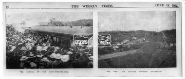
Photograph, The Weekly Times, Opening of the Heidelberg-Eltham Railway Line, 6 June 1902, 1902
Reproduced from "The Weekly Times", 14th June 1902, page 10. 06 Jun 1902 Cross Reference Photo No.(s): 602, 604 Source: La Trobe Library and National Library, Canberra THE HEIDELBERG TO ELTHAM RAILWAY. OPENING CEREMONY. The opening of the railway line from Heidelberg to Eltham took place on the 6th inst. The special train, containing a large number of members of Parliament, including Mr Trenwith, the Minister for Railways, left Prince's Bridge at half-past eleven, and arrived at Eltham at twenty minutes past twelve. The party was accompanied by Mr Fitzpatrick, Acting Commissioner for Railways; Mr Lockhead, the Traffic Manager; and Mr Norman, Engineer for Existing Lines. On arrival, the visitors were entertained at a banquet in the marquee, of which a photograph is given, erected close to the railway station. Mr E. H. Cameron, M.L.A., the member for the district, occupied the chair, and, seated on his right, was Mr Mason, the Speaker of the Legislative Assembly, and on his left the Minister of Rail-ways. After the banquet His Excellency the Governor-General arrived, and was received and welcomed by Mr Cameron, the local State school children singing the National Anthem. The Governor-General, in declaring the line open, said that he felt highly honored at being asked to perform the opening ceremony, and he trusted that the railway would be a source of great convenience to the inhabitants of the district. He was sorry to say that this would be the last opportunity he would have of seeing them. It cost him a great deal to leave them. (Hear, hear.) He had a great many friends amongst all sections of the community, and he could hardly bear to trust himself to speak about leaving them. (Hear, hear.) He was sorry Lady Hopetoun was on the high seas, and unable to accompany him that day. Mr Cameron thanked his Excellency for performing the opening ceremony, and hoped the trip home would have the effect of restoring His Excellency to good health again. In replying. Lord Hopetoun thanked them sincerely for the cordial vote of thanks. He hoped Providence would shower her blessings over them, and that they would have a series of good seasons. He would always keep a warm corner in his heart for the people of Victoria. (Loud cheers.) THE COUNTRY. In our illustrations, views are given of a couple of sections of the new line, and glimpses of the surrounding country are shown. The line is eight miles in length, and cost £51,000 in construction. Eltham, which is the terminus, possesses many of the features that go to make a favorite holiday resort. It is a quiet picturesque little hamlet, snugly ensconced on the slope of one of many sombre-tinted hills by which it is sur-rounded. Even when viewed under ad-verse conditions one could not fail to be-impressed with the natural, rugged beauty of the place. It is situated about sixteen miles from Melbourne, and the line takes a circuitous course through a continuation of pretty undulating country. At intervals on the slopes of the surrounding green-mantled hills, patches of brown, freshly tilled soil indicate that for all its serene reposeful-ness Eltham possesses its phases of industrial life as well. Looking down into this valley from the main road which skirts the slope of a hill, distant something less than a quarter of a mile from the railway station is one of the prettiest pieces of scenery in the district. Verdure-clad hills ascend on all sides, whilst beneath stretches a broad expanse of carpet-like green sward, dotted here and there with picturesque homesteads, each with its patches of tilled soil. In the township itself the dwelling-houses are comparatively few, the larger portion of the inhabitants residing in the scattered homesteads. Eltham is as yet only in its youth, but energetic and un-tiring public men can effect wonders in a community's prosperity, and Eltham, whatever other real or imaginary advantages it may lay claim to, certainly possesses this one. The railway is the result of their endeavor. 1902 'THE HEIDELBERG TO ELTHAM RAILWAY.', Weekly Times (Melbourne, Vic. : 1869 - 1954), 14 June, p. 14. , viewed 26 Sep 2018, http://nla.gov.au/nla.news-article221230719This photo forms part of a collection of photographs gathered by the Shire of Eltham for their centenary project book,"Pioneers and Painters: 100 years of the Shire of Eltham" by Alan Marshall (1971). The collection of over 500 images is held in partnership between Eltham District Historical Society and Yarra Plenty Regional Library (Eltham Library) and is now formally known as the 'The Shire of Eltham Pioneers Photograph Collection.' It is significant in being the first community sourced collection representing the places and people of the Shire's first one hundred years.Digital image 35mm B&W negativesepp, shire of eltham pioneers photograph collection, eltham, heidelberg-eltham railway extension -
 Eltham District Historical Society Inc
Photograph - Digital Photograph, Alan King, Cameron family graves, Kangaroo Ground Cemetery, Eltham-Yarra Glen Road, Kangaroo Ground, 28 January 2008
Six year old Judith Furphy was the first person known to have been buried at Kangaroo Ground Cemetery in May 1851. The cemetery is situated on an ancient river bed with exposed Nillumbik sands. The rest of the district is formed from black volcanic soil which was hard to dig. According to local historian Mick Woiwod (deceased) the site may have been a burial ground for the local Wurundjeri people as the exposed softer sands were always their prefered camping sites. The Hon. Ewen Hugh Cameron who lived at Pigeon Bank and was the Member for Evelyn for 40 years (1874-1914) was buried here in 1915. Published: Nillumbik Now and Then / Marguerite Marshall 2008; photographs Alan King with Marguerite Marshall.; p39 The Wurundjeri people might have buried their dead on the site of the Kangaroo Ground Cemetery, according to local historian Mick Woiwod. Kangaroo Ground was a premier hunting ground, but camping on the black volcanic soil would have been uncomfortable. Unlike most of Kangaroo Ground, its cemetery, on an ancient river bed, comprises a rare exposure of Nillumbik sands – always the preferred campsite for Aboriginal people. The cemetery area is the only place where the soil was soft enough to dig a grave easily.1 Six-year-old Judith Furphy was the first person known to have been laid to rest at the Kangaroo Ground Cemetery. She died on May 17, 1851, from a chill caught by resting on wet grass. Local Andrew Ross wrote ‘..no public burying place existed nearer than Melbourne. The case being considered urgent, a general meeting of the settlers took place on the evening of the 17th……. The result was the selection of unoccupied crown land …….which was subsequently granted by Government for a public cemetery.’2 Judith was buried the next day on May 18. Her grave was marked by the trustees with a plaque, which unfortunately states nine years old, when she was probably only six. Judith came from an illustrious family. Her brother, Joseph, was the author of Such is Life and other works. Another brother, John, developed and manufactured the famous Furphy water cart, which distributed water to World War One soldiers along with the latest rumours. Hence the name Furphy entered the Australian idiom, as synonymous with ‘rumour’. Judith’s father Samuel helped build the first Kangaroo Ground church school. Inside, near the entrance of the cemetery, on Yarra Glen Road, stand a rotunda and a water tank. Occasional benches invite mourners to pause and remember. The gate with wrought iron and brick supports, bears the inscription ‘Erected by Sir Ewen and Lady Cameron in memory of their daughter, Flora Margaret’. These are only two of the famous people connected with this cemetery. The Hon. Ewen Hugh Cameron JP and MLA from 1874 to1914, who lived at Pigeon Bank, Warrandyte Road, was buried here in 1915. Unrelated, but with the same name, was Sir Ewen Cameron who had been Minister for Health and was laid to rest there in 1964. Sir Herbert Gepp, a leading industrialist and the former owner of Garden Hill, at Yarra Glen Road, was buried there in 1954.3 Many of the more imposing tombstones belong to the earlier graves. Unfortunately bushfires have cracked several. But this adds to the melancholy attractiveness of the cemetery, graced by some beautiful eucalypts, cypress and pines. Early pioneering families represented at the cemetery include Armstrong, Barr, Bell, Harkness, Jardine, Johnston, Rogerson, Stevenson, Thomson and Walters. Armstrong and Bell were among the first families to come to the district and Stevenson owned the district’s first sheep station. It took in much of present day Christmas Hills, which was the name he gave his sheep station. Harkness was the first to suggest a Kangaroo Ground school be built, and one of the first to suggest establishing the Eltham District Road Board. Many of these families leased pastoral land before the mid-century and bought land when it came on sale in 1849. In the cemetery’s early days sections were devoted to the major Christian denominations (mainly the Protestant) and one section was set aside for ‘other’ or ‘non-believers’. However in modern times burial plots have not been placed in areas according to religious beliefs.This collection of almost 130 photos about places and people within the Shire of Nillumbik, an urban and rural municipality in Melbourne's north, contributes to an understanding of the history of the Shire. Published in 2008 immediately prior to the Black Saturday bushfires of February 7, 2009, it documents sites that were impacted, and in some cases destroyed by the fires. It includes photographs taken especially for the publication, creating a unique time capsule representing the Shire in the early 21st century. It remains the most recent comprehenesive publication devoted to the Shire's history connecting local residents to the past. nillumbik now and then (marshall-king) collection, kangaroo ground, eltham-yarra glen road, agnes bell cameron, agnes cameron (nee bell), cameron family, edward aubrey haughton, eugene cameron, evelyn florence cameron, ewen hugh cameron, gravestones, jane armstrong, jane bell, jessie agnes haughton (nee cameron), jessie cameron, john donald cameron, kangaroo ground cemetery, neville cameron, simon armstrong, vera cameron, william bell armstrong, wurundjeri -
 Ringwood and District Historical Society
Document, Ringwood Technical School, 1982 - Policies, Structures, Roles, SRC, Camp Duncan Rules etc
Set of Documents describing school policies, structure, roles, SRC, Camp Duncan, subject coding, emergency procedures etc. Scanned in 6 parts due to volume of pages. Most pages are not numbered. Donated by Joan Pickford (nee Dear) 2022. (Prefect 1970-71). The Index pdf lists the contents of each part but is repeated here: Part 1 • General Educational Policy • Procedures Adopted By The Curriculum Board In Order To Implement The Educational Policy Part 2 • School Administrative Structure o Operational Structure - Operations Committee o Curriculum Board o Org Chart • Role of the Senior Teacher • Role of Head of Department • Role of Assistant with Responsibility • Role of Year Level Coordinator • Role of Section Leader Part 3 • Role of the Welfare Officer • Bell Times 1983 • School Layout • Evacuation Procedure and Diagram • Recording of Students’ Attendance • Staff Absences • Concerning School Rules Part 4 - SRC • Students; Representative Council – Constitution and Rules Part 5 – Camp Duncan, Excursion etc • Camp Duncan Disposition of Duties 1983 • Receipts/forms pro-forma • Some Facts About Camp Duncan • Camp Duncan Date 1983 • Student Checklist and Luggage Requirements for Camps and excursions • Confidential Medical Report for School Camps • Parental Permission Form Part 6 • Education Department Victoria o Pay Advice and Allowance Table o Subject Coding o Leave o General Advice on Transfers o Excursion procedure, Approval Form • Student Assembly Points rts, ringwood tech -
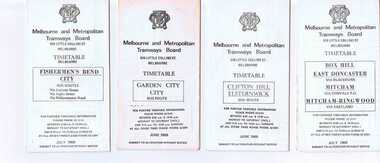 Ballarat Tramway Museum
Ephemera - Timetable/s, Melbourne and Metropolitan Tramways Board (MMTB), Set of 14 MMTB Melbourne bus timetables, 1969
Set of 14 MMTB timetables for various bus routes, dated July 1969. Generally includes Sat and Suns, Good Friday and Christmas day as well as weekdays, unless noted otherwise. Also includes a map of the route, detailed time points, sections, connecting services, fares, and organisation address - 616 Little Collins St. Melbourne. Have been folded into eight or ten portions. All on white paper unless noted otherwise. Items shown with an # - have a sticker modifying timetable information details on the front page. Items shown with a % are larger size sheets of paper, folded into 10. 1155.1 - Clifton Hill - Elsternwick # .2 - Garden City - City # .3 - Fishermen's Bend - City .4 - Box Hill - East Doncaster via Blackburn, Mitcham via Donvale PO and Mitcham - Ringwood via Eastland .5 - Warrandyte via Templestowe, via East Doncaster, Donvale PO - City % .6 - Warrandyte, Park Orchards Ringwood .7 - Williamstown Rd., Footscray Railway Station, Ballarat Rd # .8 - Latrobe University, Northland, West Heidelberg - City # % .9 - Deer Park, Sunshine Park, Sunshine, Footscray - City # .10 - as above, but for Saturdays and Sundays on pink paper # .11 - Box Hill, Heidelberg, Templestowe .12 - Box Hill, North Blackburn .13 - East Kew, Box Hill, Doncaster .14 - Bullen, North Kew - City # % Images of a sample of documents added 16-11-2013. mmtb, timetables, melbourne -
 Ballarat Tramway Museum
Document - Folder with papers, Robert Ashley, "Ballarat SEC History", 1989
Samizone flat file, made from manila card with blue printing for file details and a Dymo machine label on the spine (red background with white printing) titled "Ballarat SEC History". On inside of folder is a "Post It" note with handwriting "Robert Ashley Ex Employee" in blue ink. Contained within folder is" 1. "Ballarat, Electricity and the State Electricity Commission" photocopied from an original. Has typed under the heading over white out correction fluid "Notes - Draft notes prepared by Robert W. P. Ashley 1989." The paper gives the history of power supply in Ballarat, including street lighting, ESCo, AC and DC power supplies, the takeover by the SEC, Ballarat A and B power stations, a copy of an advertisement for the SEC in Ballarat. (See btm1701i3.jpg) titled "The Power Behind the Switch" 2. Paper by A. D. Senior, titled "Electricity Supply in Ballarat" - see Reg. Item No. 1700. (see btm1700i.pdf) 3. Photocopied onto foolscap paper of an extract from possibly a large report on power supply in Victoria. Pages 155 to 158. Reports on the history of the power supply system in Ballarat until the takeover of ESCo by the SEC. Further details are referred to another section of the Report on the SEC itself. On page 158 are details of Beaufort Council operated supply and the start of notes on Beechworth. (see btm1701i2.pdf) Images of files added 6-8-15 For an image of the advert itself see btm1701i3.pdfSee notes above.trams, tramways, secv, power supply, esco, beaufort -
 Ballarat Tramway Museum
Document - Lecture Notes, Metropolitan Transit Authority (MTA), "Tramway Permanent Way", 1987
Seventy two page photocopied document within card covers and outer plastic covers with an additional introduction page between front clear plastic cover and card cover bound with a white comb binder. Book titled "Tramway Permanent Way" presenting a series of lectures by MMTB Per Way officers in 1928 at Hawthorn Depot. Contents in order: 1. Handwritten note from Chris Jacobson on Metropolitan Transit Authority of Victoria memo paper forwarding a copy to Warren Doubleday of the BTPS in Feb. 1988, with date received stamp at depot of 19/2/1988. 2. Photocopy of a memo on Metropolitan Transit letterhead from K. C. Painter dated 20/7/1987 to the Civil Engineering Design drafting staff forwarding a copy of the 1928 lectures to the then current staff. 3. Photocopy of a circular from J.P. Strickland, Chief Engineer to track inspectors, sub overseers, overseers and senior gangers advising that a series of weekly lectures on track work would be held at Hawthorn Depot commencing 23/1/1928. 4. Lecture notes: 1. Interpretation of Drawings 2. Alignment etc 3. Alignment continued and special work 4. The drainage system 5. Concrete 6. Rails and Fastenings 7. Welding 8. Timber 9. Paving and paving materials 10. Track cross sections. Second copy added 27/11/2010 - ex PPW holdings. Both items transferred to Box 99.\ Scanned copy added 15-12-2016.trams, tramways, trackwork, mmtb, lectures, tramway per way, training -
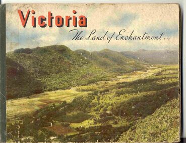 Ballarat Tramway Museum
Book, Nu-color-vue or Nucolorvue Productions, "Victoria The Land of Enchantment", c1950
Book with hardcovers, 48 pages titled "Victoria The Land of Enchantment". Sewn in three sections, with a green strip of cloth and self end papers and printed outer paper, sides glued onto board covers. Consists of 43 colour photographs (full and half page) with captions, detailed text, and two black and white photos printed in blue on end covers. Photos of Mt Buffalo, Gippsland lakes, Mornington Beach, Yarra River, Flinders St. station from the Yarra, Collins and Spring St (with two W2's - see image No. 2), Parliament House, Kiewa Hydro scheme, Eildon Weir, Swan Hill Murray River Bridge, Bendigo Post Office, Melbourne Botanical Gardens, Ballarat - Grenville and Sturt St (No. 22 - see image No. 3), Lorne, Yallourn Power Station, Hume Weir, Maroondah Weir, Great Ocean Road, Warrnambool, Portland Beach, A timber train (see image No. 4), Mildura, flax mills, Eastern Geelong and the Prime Ministers Ave, Ballarat. Produced by Nucolorvue Productions, c1950. See also Reg Item 2925 for the same photo of No. 22 and Reg Item 5354 for a postcard. Purchased via eBay site - see attached sheets and packing slip. Purchased 10/2/2005 for A$12.50 including postage, from Virginia Georgopoulos of West Brunswick. eBay sheets and envelope with worksheet file. Has Swains 123 Pitt St, Sydney sticker on bottom left hand corner page 2trams, tramways, ballarat, sturt st, grenville st, bogie trams, geelong, bendigo, melbourne -
 Ballarat Tramway Museum
Book, State Electricity Commission of Victoria (SECV), "Electric Tramways of the State Electricity Commission of Victoria By-Law No. 1", 1943
Demonstrates aspects of the SEC governance system in issuing By-laws for the travelling public, as part of their Act. Yields information about fares charged for tram services in Ballarat, Bendigo and Geelong. Issued to crews.Twenty Four page booklet, plus medium weight card brown colour covers centre stapled. Book cover has title "Electric Tramways of the State Electricity Commission of Victoria By-Law No. 1". Pages are numbered pages 1 to 24, revoking By Laws dated 5/9/1932 (See Reg. Item 3109). Dated 9/3/1937. Gives definitions, fares and charges, regulations re passengers, behaviour, smoking, dangerous goods, luggage and behaviour of crews. Gives schedule of fares and charges for Ballarat, Bendigo and Geelong. Fares applied from 1937 to 1949 - see Reference. Details names of SEC Commissioners, Minister in Charge of Electrical Undertakings. Four copies held. Copy 1 - as printed. Copy 2 - has numerous changes marked in red ink internally and pasted in changes to the text. The schedules have been crossed out. Copy 3 - has changes marked in black ink, including fare and charges changes that were made in 1949. No pasted in sections. Copy 4 - missing back cover. Copy 5 - missing front and back pages. Has Government Printer, H. E. Daw, number 11928/43. Given the printing number on Reg. Item 3110 is a lower number and that the H. Green was the Government Printer in 1936 (See Reg. Item 3068), "43" indicates a reprinting date. See Fares in Ballarat – from Alan Bradley 11/4/2005 – appendix for Book Copy 1 - has "1937" and "No. 1" written in red ink on top of cover. Copy 2 - has "No. 2" written in red ink in top right hand corner of cover and "Ballarat Tramway Preservation Society No. 202" written in black ink on top of cover and numerous changes marked in red ink internally and pasted in changes to the text. The schedules have been crossed out in red ink. Copy 3 - has "Ballarat Tramway Preservation Society No. 202" written in black ink on top of cover and numerous changes marked in black ink including changes to fares and schedules.trams, tramways, secv rules, by laws, tickets, fares, ballarat, bendigo, geelong -
 Kew Historical Society Inc
Plan, Borough of Kew Detail Plan No.1577, 1904
The Melbourne and Metropolitan Board of Works (MMBW) plans were produced from the 1890s to the 1950s. They were crucial to the design and development of Melbourne's sewerage and drainage system. The plans, at a scale of 40 feet to 1 inch (1:480), provide a detailed historical record of Melbourne streetscapes and environmental features. Each plan covers one or two street blocks (roughly six streets), showing details of buildings, including garden layouts and ownership boundaries, and features such as laneways, drains, bridges, parks, municipal boundaries and other prominent landmarks as they existed at the time each plan was produced. (Source: State Library of Victoria)This plan forms part of a large group of MMBW plans and maps that was donated to the Society by the Mr Poulter, City Engineer of the City of Kew in 1989. Within this collection, thirty-five hand-coloured plans, backed with linen, are of statewide significance as they include annotations that provide details of construction materials used in buildings in the first decade of the 20th century as well as additional information about land ownership and usage. The copies in the Public Record Office Victoria and the State Library of Victoria are monochrome versions which do not denote building materials so that the maps in this collection are invaluable and unique tools for researchers and heritage consultants. A number of the plans are not held in the collection of the State Library of Victoria so they have the additional attribute of rarity.Original survey plan, issued by the MMBW to a contractor with responsibility for constructing sewers in the area identified on the plan within the Borough of Kew. The plan was at some stage hand-coloured, possibly by the contractor, but more likely by officers working in the Engineering Department of the Borough and later Town, then City of Kew. The hand-coloured sections of buildings on the plan were used to denote masonry or brick constructions (pink), weatherboard constructions (yellow), and public buildings (grey). MMBW Plan No.1577 includes some of the most significant houses in Kew: Herbert Henty’s ‘Roxeth’ (now part of Trinity Grammar), ‘Butleigh Wooton’, ‘Bokara’ and ‘Harrow’. It also includes the streets that have since changed their names. That part of College Parade linked to Glenferrie Road is now named College Place, College Parade now extends further north, and Charles Street did not yet reach Barkers Road. Roxeth is one of a number of Henty houses in Kew. Herbert Henty made his home here and was elected a member of Kew Municipal Council in 1864 and mayor in 1868-69. Walter Henry Serle, of Harrow served in the First World War. He was awarded the Military Medal ‘’For conspicuous bravery and devotion to duty. On 29th September near BELLICOURT he showed the greatest bravery and determination when his platoon was attacked by enemy bombing parties. It was due largely to his personal efforts that all the attacks were repulsed. Until wounded, his utter disregard of personal safety and boldness in dealing with the attacks were the means of saving the situation and were an inspiring example to his men.’melbourne and metropolitan board of works, detail plans, maps - borough of kew, mmbw 1577, cartography -
 Kew Historical Society Inc
Plan, Melbourne and Metropolitan Board of Works, Borough of Kew : Detail Plan No.1580, 1904
The Melbourne and Metropolitan Board of Works (MMBW) plans were produced from the 1890s to the 1950s. They were crucial to the design and development of Melbourne's sewerage and drainage system. The plans, at a scale of 40 feet to 1 inch (1:480), provide a detailed historical record of Melbourne streetscapes and environmental features. Each plan covers one or two street blocks (roughly six streets), showing details of buildings, including garden layouts and ownership boundaries, and features such as laneways, drains, bridges, parks, municipal boundaries and other prominent landmarks as they existed at the time each plan was produced. (Source: State Library of Victoria)This plan forms part of a large group of MMBW plans and maps that was donated to the Society by the Mr Poulter, City Engineer of the City of Kew in 1989. Within this collection, thirty-five hand-coloured plans, backed with linen, are of statewide significance as they include annotations that provide details of construction materials used in buildings in the first decade of the 20th century as well as additional information about land ownership and usage. The copies in the Public Record Office Victoria and the State Library of Victoria are monochrome versions which do not denote building materials so that the maps in this collection are invaluable and unique tools for researchers and heritage consultants. A number of the plans are not held in the collection of the State Library of Victoria so they have the additional attribute of rarity.Original survey plan, issued by the MMBW to a contractor with responsibility for constructing sewers in the area identified on the plan within the Borough of Kew. The plan was at some stage hand-coloured, possibly by the contractor, but more likely by officers working in the Engineering Department of the Borough and later Town, then City of Kew. The hand-coloured sections of buildings on the plan were used to denote masonry or brick constructions (pink), weatherboard constructions (yellow), and public buildings (grey). The area represented in this detail plan has undergone significant change during the 20th century. The widening of High Street in the 1930s and 1950s involved the shops on the south side of High Street being demolished and later rebuilt to fit the widened street. Another significant loss was the mansion ‘Drayton’ fronting Wellington Street, owned at this stage by Susannah Fenton. Her family name would later to be given to Fenton Way, which was to be built over the grounds of the house following its demolition. The plan of the garden is particularly interesting, containing a batten dome fronting Wellington Street, an ornamental pond, a fountain and a brick and glass conservatory. The notes by the plumbing contractor on this plan are particularly detailed. Pink borders delineate the ownership of the varying parcels of land. Some of the better known owners listed include the real estate agent Cr. Henry de Castres Kellett (bt) and John Padbury, the funeral director. This particular plan provides a clear view of the configuration of the Kew Junction in 1903 and the commercial buildings that surrounded it.melbourne and metropolitan board of works, detail plans, maps - borough of kew, mmbw 1580, cartography -
 Kew Historical Society Inc
Plan, Melbourne & Metropolitan Board of Works : Borough of Kew : Detail Plan No.1582, 1904
The Melbourne and Metropolitan Board of Works (MMBW) plans were produced from the 1890s to the 1950s. They were crucial to the design and development of Melbourne's sewerage and drainage system. The plans, at a scale of 40 feet to 1 inch (1:480), provide a detailed historical record of Melbourne streetscapes and environmental features. Each plan covers one or two street blocks (roughly six streets), showing details of buildings, including garden layouts and ownership boundaries, and features such as laneways, drains, bridges, parks, municipal boundaries and other prominent landmarks as they existed at the time each plan was produced. (Source: State Library of Victoria)This plan forms part of a large group of MMBW plans and maps that was donated to the Society by the Mr Poulter, City Engineer of the City of Kew in 1989. Within this collection, thirty-five hand-coloured plans, backed with linen, are of statewide significance as they include annotations that provide details of construction materials used in buildings in the first decade of the 20th century as well as additional information about land ownership and usage. The copies in the Public Record Office Victoria and the State Library of Victoria are monochrome versions which do not denote building materials so that the maps in this collection are invaluable and unique tools for researchers and heritage consultants. A number of the plans are not held in the collection of the State Library of Victoria so they have the additional attribute of rarity.Original survey plan, issued by the MMBW to a contractor with responsibility for constructing sewers in the area identified on the plan within the Borough of Kew. The plan was at some stage hand-coloured, possibly by the contractor, but more likely by officers working in the Engineering Department of the Borough and later Town, then City of Kew. The hand-coloured sections of buildings on the plan were used to denote masonry or brick constructions (pink), weatherboard constructions (yellow), and public buildings (grey). Public buildings, coloured grey on the Plan 1582 include the police station and post office, churches and schools. The earliest church school, Common School No.356 was located at the rear of the Congregational Church in Peel Street. It was constructed in 1859. The first buildings of Kew Primary School No.1075 on the other side of Peel Street were constructed in 1871. The school in 1903 only occupied a small fraction of its current site. In 1903, where the rear playground is now located, were two weatherboard and one brick villa. Trinity Grammar School was founded in 1902 and opened in the Parish Hall at the rear of Holy Trinity Anglican Church. It was not to move to its current site until 1906. The outline of the building housing the Kew Fire Brigade in the centre of the north side of Walton Street is shown but not named on the plan. Further down Pakington Street stood the two-storey Italianate mansion ‘Overton’. The home of Stanford Chapman, it was to be featured in the Imperial Institute series of bromide photographs of Victoria, Vol. 1: Homes and scenery. It was later to become a boarding house before it was later demolished.melbourne and metropolitan board of works, detail plans, maps - borough of kew, mmbw 1582, cartography -
 Kew Historical Society Inc
Plan, Melbourne & Metropolitan Board of Works : Borough of Kew : Detail Plan No.1585, 1904
The Melbourne and Metropolitan Board of Works (MMBW) plans were produced from the 1890s to the 1950s. They were crucial to the design and development of Melbourne's sewerage and drainage system. The plans, at a scale of 40 feet to 1 inch (1:480), provide a detailed historical record of Melbourne streetscapes and environmental features. Each plan covers one or two street blocks (roughly six streets), showing details of buildings, including garden layouts and ownership boundaries, and features such as laneways, drains, bridges, parks, municipal boundaries and other prominent landmarks as they existed at the time each plan was produced. (Source: State Library of Victoria)This plan forms part of a large group of MMBW plans and maps that was donated to the Society by the Mr Poulter, City Engineer of the City of Kew in 1989. Within this collection, thirty-five hand-coloured plans, backed with linen, are of statewide significance as they include annotations that provide details of construction materials used in buildings in the first decade of the 20th century as well as additional information about land ownership and usage. The copies in the Public Record Office Victoria and the State Library of Victoria are monochrome versions which do not denote building materials so that the maps in this collection are invaluable and unique tools for researchers and heritage consultants. A number of the plans are not held in the collection of the State Library of Victoria so they have the additional attribute of rarity.Original survey plan, issued by the MMBW to a contractor with responsibility for constructing sewers in the area identified on the plan within the Borough of Kew. The plan was at some stage hand-coloured, possibly by the contractor, but more likely by officers working in the Engineering Department of the Borough and later Town, then City of Kew. The hand-coloured sections of buildings on the plan were used to denote masonry or brick constructions (pink), weatherboard constructions (yellow), and public buildings (grey). This plan, which covers parts of High Street, Pakington Street and Derby Street is dominated by two historic Kew mansions: ‘Konetta’ and ‘Ramornie’. Ramornie was constructed in 1890 for James Maitland Campbell, three times Mayor of Kew. Sold in 1940, it became a boarding house known as ‘The Towers’. Now a private residence again, it has only one of its three balconies remaining. The location of the missing two balconies can be seen on the plan. In 1903, the grounds of Ramornie included a large tennis court fronting Pakington Street. The rear of the property is shown as extending to Cobden Street. One of Kew’s oldest hotels, the Prospect Hill Hotel on the corner of High and Cobden Street was established in 1858. The outline of the hotel shown on the plan represents the second building on the site. During the 19th century it was often used for electoral meetings. The Prospect Hill Hotel was to be redeveloped again in 1928, by the local architect Robert McIntyre. Since the 1980s, the hotel has been a live music venue, the home of the Melbourne Jazz Club, a restaurant and a liquor outlet.melbourne and metropolitan board of works, detail plans, maps - borough of kew, mmbw 1585, cartography -
 Kew Historical Society Inc
Plan, Melbourne & Metropolitan Board of Works : Borough of Kew : Detail Plan No.1588, 1904
The Melbourne and Metropolitan Board of Works (MMBW) plans were produced from the 1890s to the 1950s. They were crucial to the design and development of Melbourne's sewerage and drainage system. The plans, at a scale of 40 feet to 1 inch (1:480), provide a detailed historical record of Melbourne streetscapes and environmental features. Each plan covers one or two street blocks (roughly six streets), showing details of buildings, including garden layouts and ownership boundaries, and features such as laneways, drains, bridges, parks, municipal boundaries and other prominent landmarks as they existed at the time each plan was produced. (Source: State Library of Victoria)This plan forms part of a large group of MMBW plans and maps that was donated to the Society by the Mr Poulter, City Engineer of the City of Kew in 1989. Within this collection, thirty-five hand-coloured plans, backed with linen, are of statewide significance as they include annotations that provide details of construction materials used in buildings in the first decade of the 20th century as well as additional information about land ownership and usage. The copies in the Public Record Office Victoria and the State Library of Victoria are monochrome versions which do not denote building materials so that the maps in this collection are invaluable and unique tools for researchers and heritage consultants. A number of the plans are not held in the collection of the State Library of Victoria so they have the additional attribute of rarity.Original survey plan, issued by the MMBW to a contractor with responsibility for constructing sewers in the area identified on the plan within the Borough of Kew. The plan was at some stage hand-coloured, possibly by the contractor, but more likely by officers working in the Engineering Department of the Borough and later Town, then City of Kew. The hand-coloured sections of buildings on the plan were used to denote masonry or brick constructions (pink), weatherboard constructions (yellow), and public buildings (grey). This plan shows the original configuration of the Kew Post Office, Court House and Police Station, which had opened in 1888. This configuration was to essentially remain until the purchase of the Court House and Police Station by the City of Boroondara in 2007 and its subsequent renovation. Interestingly, the MMBW surveyors incorrectly labelled parts of the complex. In the triangle in front of the Post Office, before the erection of the Kew Cenotaph in 1925, was located a lawn and the Queen Victoria Jubilee Fountain. While many of the shops on the south side of High street had been constructed by 1903 a number of sites were still used as vegetable gardens. Further along High Street, on the corner of Charles Street, the Salvation Army Barracks can be seen on the plan. These Barracks predate the later Citadel and ‘Young People’s Hall’ that were opened in 1919. At 22 Charles Street can be seen the house of James Venn Morgan. Hailed as the ‘father of Kew’, Morgan arrived in Melbourne in 1840. He was first engaged as a bookmaker, but a fortunate venture on the goldfields enabled him to purchase land in Kew. He conducted a market garden and dairy in Kew for many years.melbourne and metropolitan board of works, detail plans, maps - borough of kew, mmbw 1588, cartography -
 Kew Historical Society Inc
Plan, Melbourne & Metropolitan Board of Works : Borough of Kew : Detail Plan No.1591, 1905
The Melbourne and Metropolitan Board of Works (MMBW) plans were produced from the 1890s to the 1950s. They were crucial to the design and development of Melbourne's sewerage and drainage system. The plans, at a scale of 40 feet to 1 inch (1:480), provide a detailed historical record of Melbourne streetscapes and environmental features. Each plan covers one or two street blocks (roughly six streets), showing details of buildings, including garden layouts and ownership boundaries, and features such as laneways, drains, bridges, parks, municipal boundaries and other prominent landmarks as they existed at the time each plan was produced. (Source: State Library of Victoria)This plan forms part of a large group of MMBW plans and maps that was donated to the Society by the Mr Poulter, City Engineer of the City of Kew in 1989. Within this collection, thirty-five hand-coloured plans, backed with linen, are of statewide significance as they include annotations that provide details of construction materials used in buildings in the first decade of the 20th century as well as additional information about land ownership and usage. The copies in the Public Record Office Victoria and the State Library of Victoria are monochrome versions which do not denote building materials so that the maps in this collection are invaluable and unique tools for researchers and heritage consultants. A number of the plans are not held in the collection of the State Library of Victoria so they have the additional attribute of rarity.Original survey plan, issued by the MMBW to a contractor with responsibility for constructing sewers in the area identified on the plan within the Borough of Kew. The plan was at some stage hand-coloured, possibly by the contractor, but more likely by officers working in the Engineering Department of the Borough and later Town, then City of Kew. The hand-coloured sections of buildings on the plan were used to denote masonry or brick constructions (pink), weatherboard constructions (yellow), and public buildings (grey). That area of Kew bordered by Cotham Road, Park Hill Road, Ermington Lane (now Ermington Place), and Belmont Avenue contained some of the significant homes owned by Kew pioneers. Chief among these was ‘Park Hill’ on an enormous lot facing Park Hill Road. The Jubilee History of 1910 noted, six years after this plan was drawn, that: ‘Park Hill Road, forming the southern boundary of the cemetery, takes its name from Park Hill, the residence of Mr. Thomas Judd, who has resided there since December, 1852.’ Other named houses on the plan include ‘Ferndale’ facing Cotham Road; ‘Ermington’ adjacent to Judd’s Park Hill, facing Park Hill Road; and ‘Gilden’ and ‘Mont Belmont’ facing Belmont Avenue. Mont Belmont was designed by the architectural firm of Reed, Henderson and Smart for William George Lilley in 1887 and was completed in 1888. Lilley was Mayor of Kew in 1887-88, a Justice of the Peace and a member of the first Board of Guardians of Kew’s St. Hilary’s Church of England.melbourne and metropolitan board of works, detail plans, survey plans - borough of kew, mmbw 1591, cartography -
 Kew Historical Society Inc
Album, Alick Kirkland Goulburn Gipps' Scrapbook, 1930s
Alick Gipps (1928-2014) was the son of Richard Brook Woodthorpe Gipps (1872-1946) and Mary Alys Kirkland (1889-1981), and the older brother of Christopher David Gipps (1930-52) and Rosemary Alison Gipps (1930-2013). While many scrapbooks of the period were created by, and or added to by their child owners, it is believed that "scrapbooks were considered by later Victorian parents to be an educational tool to teach children how to organise and classify information and to develop their ‘artistic’ senses" (Margaret Simpson, MAAS, 2008), and that the scrapbooks may have been compiled by the parent, rather than the child.The scrapbook is part of a large and significant collection of items donated by Rosemary Vaughan-Smith, past member and office-bearer of the Kew Historical Society. between 2005-12. The collection includes costumes, scrapbooks, autograph books, artworks and objects.Hard cover, 50-page album covered in red cloth and red leather corners and spine, the latter embossed with the words 'SCRAP BOOK' in gilt lettering. On the inside front cover, top left is an oval green label with retailer information - "WEDDING CHRISTENING / R. E. PENN. / Bible Warehouse / 213 REGENT St / BIRTHDAY PRESENTS". The paper used for the pages are in alternating blue, cream and green-coloured sections. The front pages of the scrapbook include the signature of the owner as Alick Kirkland [Goulburn] Gipps (1928-2014). Items pasted into the scrapbook include black and white and coloured illustrations, photographs, and extracts from books. Items selected for the scrapbook fill a single page or are arranged in groups. The oldest items in the scrapbook appear to date from 1859 and include a colour cover of the Illustrated London Almanack and pictorial handbills of electoral results for the seat of Holmesdale and Filmer in Kent, England. While other items in the book are of later periods, most can be classified as sentimental Victorian-era illustrations. The biblical scenes in the scrapbook reflect one aspect of the values of the Gipps family. The focus in the album on material about or published in Great Britain also suggests a preoccupation with, and a valuing of, traditional British culture. This is confirmed by the memberships of Alick and his sister Rosemary (Gipps) Vaughan-Smith in the English-Speaking Union Club, for which they welcomed guests at an 'Elizabethan party and barbecue' during the Coronation festivities of June 1953. (The Age, 3 June 1953, page 5). The album entered the collection of the Kew Historical Society as part of the Raymond and Rosemary (Gipps) Vaughan-Smith donation.manuscripts - kew historical society, rosemary vaughan-smith, vaughan-smith collection, alick kirkland goulburn gipps, scrapbooks - 20th century -
 Kew Historical Society Inc
Plan, Melbourne & Metropolitan Board of Works : Borough of Kew : Detail Plan No.1563, 1905
The Melbourne and Metropolitan Board of Works (MMBW) plans were produced from the 1890s to the 1950s. They were crucial to the design and development of Melbourne's sewerage and drainage system. The plans, at a scale of 40 feet to 1 inch (1:480), provide a detailed historical record of Melbourne streetscapes and environmental features. Each plan covers one or two street blocks (roughly six streets), showing details of buildings, including garden layouts and ownership boundaries, and features such as laneways, drains, bridges, parks, municipal boundaries and other prominent landmarks as they existed at the time each plan was produced. (Source: State Library of Victoria)This plan forms part of a large group of MMBW plans and maps that was donated to the Society by the Mr Poulter, City Engineer of the City of Kew in 1989. Within this collection, thirty-five hand-coloured plans, backed with linen, are of statewide significance as they include annotations that provide details of construction materials used in buildings in the first decade of the 20th century as well as additional information about land ownership and usage. The copies in the Public Record Office Victoria and the State Library of Victoria are monochrome versions which do not denote building materials so that the maps in this collection are invaluable and unique tools for researchers and heritage consultants. A number of the plans are not held in the collection of the State Library of Victoria so they have the additional attribute of rarity.Original survey plan, issued by the MMBW to a contractor with responsibility for constructing sewers in the area identified on the plan within the Borough of Kew. The plan was at some stage hand-coloured, possibly by the contractor, but more likely by officers working in the Engineering Department of the Borough and later Town, then City of Kew. The hand-coloured sections of buildings on the plan were used to denote masonry or brick constructions (pink), weatherboard constructions (yellow), and public buildings (grey). This plan covers the area between Barkers Road, Wrixon Street, Sackville Street and Brougham Place, much of it now occupied by Carey Baptist Grammar and Preshil schools. This was an area of large and prestigious homes in 1903, some with formally laid-out gardens, such as ‘Tower Hill’ and ‘Opawa’. ‘Kalimna’ was built in 1890-91 for William H. Jarman, an accountant, and ‘Blackhall’ at the same time for W.H. Roberts. Blackhall was to be acquired by the Salvation Army in 1915 and renamed ‘Catherine Booth Girls’ Home’. The Home accommodated girls, aged between 4 and 16. Kalimna and Blackhall are of significance as typical and intact late Victorian mansions and as such are two key Victorian buildings to have been built in Kew. Both Blackhall and Kalimna are now part of Preshil. ‘Fairview’ was for a long time occupied by the Sisters of St. Joseph of Cluny as a care home for the elderly, but it is now part of Carey Grammar School, as are the grounds of ‘Wagga Merne’, ‘Weemutta’, ‘Blakely’, ‘Daheim’ and ‘Mildura’ (later ‘Urangeline’), the last being particularly impressive in 1903, with a tennis court, conservatory, outhouses, and two bathrooms!melbourne and metropolitan board of works, detail plans, mmbw 1563, cartography