Showing 17174 items matching "bay-bridge"
-
 National Wool Museum
Sculpture - Bollard, Jan Mitchell, The Lost Bollards, 1999
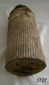
Geelong is famous for its bollards. Created by local artist Jan Mitchell, the colourful bollards spot the foreshore, representing a fascinating and fun chronicle of the city’s past. Few people know that Mitchell planned for a flock of sheep to be part of her public art project. The wool industry is an important part of Geelong’s history, so Mitchell thought what better than a flock of sheep to welcome people to the city. The flock (and a Shepard) were to be placed out on the Melbourne-Geelong highway, near Lara, to welcome travellers to the city. The sheep would then be scattered along the road as a wayfinding signal to bring people to Geelong. When traffic authorities heard the plan for bollard sheep along the road, they squashed the project as a potential distraction for drivers. Another flock was also suggested for the hills of the eastern gardens, overlooking the bay. This was also disapproved; so Mitchell only ever partially completed four sheep bollards. The bollards are remnants of Jan Mitchell’s flock of sheep. The sheep also show the evolution of one of Geelong’s most iconic art installations. From the first sheep showing the raw timber of the old Yarra Street pier, to the sheep without a face, through to the completed sheep, it is possible to trace Mitchell’s process in the preparation of the bollards. The lost bollards form part of the National Wool Museum’s unique collection. The first bollard is the least complete, still in its original timber colour. From the central cylindrical shape, an additional wedge protrudes. This unpainted wedge forms what would have been the face of the sheep, with an ear present on either side that would have been painted white. Presently they are a bare metal. No legs are present on this bollard. The second and third bollard are completed to a similar level. They have a central cylindrical shape with an additional wedge protruding from the front of the timber. This wedge forms what would have been the face of the sheep, with an ear present on either side. The face and ears have been painted white but the finer details such as the eyes have not been added. These bollards bodies have also been painted white and have their legs attached. The legs are thin metal cylinders, approximately 50mm in diameter and 500mm long. The fourth bollard Is complete. It has the same central cylindrical shape with an additional wedge protruding from the front of the timber. This wedge forms the completed face of the sheep, with an ear present on either side that has been painted white. The face also features completed painted eyes. This bollard has its legs attached. The legs are thin metal cylinders, approximately 50mm in diameter and 500mm long. geelong, bollards, geelong's bollards, jan mitchell -
 Otway Districts Historical Society
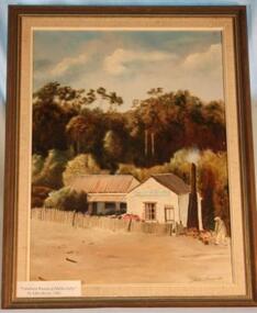
Painting - Oil painting, framed, The Luncheon Rooms at Melba Gully, 1981
Forming the headwaters of the Johanna River and noted for its majestic Myrtle Beech and Blackwood trees, in 1921 the property came into the possession of Mrs Jessie Fry, wife of Mr Thomas Fry, a well-known and respected local bushman and timber getter. Here the family lived and it was Mrs Fry who named the place 'Melba Gully'. Sometime in the late 1920s Mrs Fry was approached by Pioneer Tours, the bus company, to see if she would provide lunches and afternoon teas for their passengers travelling between Apollo Bay and Port Campbell. Mrs Fry rose to the challenge; the Melba Gully Luncheon Rooms were built adjoining the Fry home and she was in business. Mrs Fry was unfailing in her courtesy and kindness. She was also a splendid cook, known for her feather-light scones and sponges. Home-produced strawberries and cream were a special treat. Visitors were also taken on a tour of 'The Gully', often guided by one of her young sons. Melba Gully Visitors Book is testimony to her many satisfied customers. Tom and Jessie Fry sold the property on her retirement in 1947 and the tearooms ceased to operate. It again changed hands in 1958 to Otway residents Mr and Mrs Axel Madsen, and in 1975 they made the magnificent gesture of gifting the 48 hectare Melba Gully to the people of Victoria..Framed painting in oils of a weatherboard house with picket fence, before a backdrop of forest. A figure chopping wood is at the right.Signature of artist John Driver, 1981melba gully, jessie fry, thomas fry, buses, tours, weatherboard house, john driver -
 Otway Districts Historical Society
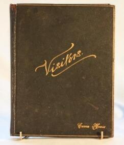
Book - Visitors Book, Melba Gully Visitors Book, 1937-1958
Forming the headwaters of the Johanna River and noted for its majestic Myrtle Beech and Blackwood trees, in 1921 the property came into the possession of Mrs Jessie Fry, wife of Mr Thomas Fry, a well-known and respected local bushman and timber getter. Here the family lived and it was Mrs Fry who named the place 'Melba Gully'. Sometime in the late 1920s Mrs Fry was approached by Pioneer Tours, the bus company, to see if she would provide lunches and afternoon teas for their passengers travelling between Apollo Bay and Port Campbell. Mrs Fry rose to the challenge; the Melba Gully Luncheon Rooms were built adjoining the Fry home and she was in business. Mrs Fry was unfailing in her courtesy and kindness. She was also a splendid cook, known for her feather-light scones and sponges. Home-produced strawberries and cream were a special treat. Visitors were also taken on a tour of 'The Gully', often guided by one of her young sons. Melba Gully Visitors Book, running from November 1937 until the end of 1958, is testimony to her many satisfied customers. Tom and Jessie Fry sold the property on her retirement in 1947 although the tearooms continued to operate. It again changed hands in 1958 to Otway residents Mr and Mrs Axel Madsen, when it finally closed, and in 1975 they made the magnificent gesture of gifting the 48 hectare Melba Gully to the people of Victoria..Melba Gully Visitors Book. Foolscap, leather-bound, lined pages with margin approximately 30mm from left. Added, 24 p. unlined quarto.Full of inscriptions, cover to coverlavers hill, melba gully, jessie fry, thomas fry, axel madsen -
 Queenscliffe Maritime Museum
Instrument - Barometer and Clock mounted on a timber cabinet and 10 associated items from the TSS Nairana, 1915
Bass Strait passenger ship Nairana. Built for Bass Strait ferry operator Huddart Parker & Co. Ltd. of Melbourne during World War One, the Nairana was requisitioned by the Royal Navy and completed as a seaplane carrier, HMS Nairana. Serving from 1917 to 1920 participating in the capture of Archangel during the Bolshevik Revolution. After 1920 she was decommissioned as a seaplane carrier and returned to her Australian owners crossing Bass Strait until she was laid up in 1948. Just off Port Phillip Heads on April 12 1936, a strong wave struck the Nairana, tipping her over for two minutes before she righted herself again. During the horrifying two minutes, four people were drowned, and eight people were injured. The ship was reportedly carrying roughly one tonne of concrete in the hull when she tipped. Reports from the local papers said that it was a tidal wave meanwhile others were saying it was either an earthquake or a total lie. A later paper said that the ship had been caught in a rip at the mouth of the bay, causing the tragedy. The S.S Nairana, was sold for £4,000 (over $170,200 in today’s money!) in 1951 after two years of being stranded on the beach at Port Melbourne, when the moorings broke one night during a storm and drifted ashore, causing her to wreck.Items associated with the TSS/HMS Nairana in its military and civilian roles and items relating to Capt. JF Spence, navigation Officer and possibly later the captain who sailed with the Nairana out of Plymouth after WWI. .01 Barometer and Clock from Dining Saloon .02 Commemorative plaque describing the HMS Nairana's WWI service with timber mount for plaque with information sheet attached. .03 Clock Key .04 Two 2 Log books owned by Capt. Spence containing the navigation calculations for the journey from Plymouth to Melbourne. .05 Huddart Parker hat badge [Capt. JF Spence].Barometer and Clock from dining saloon, TSS Nairana 1917 - 1951 Clock Key - 4 50-No9 Hat badge - HPtss nairana, wwi, bass strait, huddart parker, capt. spence -
 National Wool Museum
Textile - Quilt, By Wagga Design, 2017
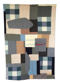
‘By Wagga Design’ is the winner of the Art Quilt Australia 2019 Expressions: Wool Quilt Prize. Barbara Mellor, of St Helens in Tasmania, made this quilt after researching the history of waggas and was fascinated by this early form of recycling. ‘By Wagga Design’ is her contemporary take on the traditional wagga that was born out of hard times and limited resources. Barbara wrote the poem below while thinking of the workers who used waggas while travelling: Black night campfire night sheep in the shadows dreams on the track a comforting wagga stitched with love for a homesick heart. The wagga was made in 2017 and was first submitted into the Bay of Fires Art Prize. In 2018 the wagga was submitted into the Break O’Day Stitchers Quilting and Embroidery Exhibition, where it won the Hanger’s Prize. Barbara sourced the fabrics used from a variety of places. Some are from her personal collection while others were given to her. She purchased a woollen three-piece suit from a local op shop and decided to incorporate it into the design, making some unique and distinctive shapes. Another distinctive feature of the quilt is the patch labelled ‘Parkside’. Barbara noted that it was cut from a blanket she purchased from a garage sale from a property that had once been a caravan park titled ‘Parkside’ in the 1960s. The filling of the wagga contains the rest of the Parkside blanket.Quilt made from various woollen garments and bedding in cool tone colours. Patches mostly cut into square and rectangle shapes. Three patches made from a second-hand woollen suit, showcasing the arm with cuff buttons, pocket flap on a hip pocket containing a pocket square and front of vest with buttons. wagga, art quilt australia, expressions: wool quilt prize -
 Flagstaff Hill Maritime Museum and Village
Weapon - Ammunition Shell, late 19th-early 20th century
Ammunition shell was used in a 40 lb Armstrong Rifled Breach Loading (RBL) Gun. The shell was fired into Westernport Bay by the Hastings Battery Field Artillery in late 1800’s or early 1900’s. It was recovered by divers in recent times. It does not contain explosives because the projectile and explosive were separate items. The Armstrong 40 lb BL Gun There were 4 x 40lb Armstrong (RBL) Guns issued to the Ham and Beef Battery at Hastings Victoria. After the Hastings Battery field artillery disbanded, the 4 Guns were transferred from the Hastings Battery to the Warrnambool Battery field artillery in 1904. (There is a photograph of one of these guns on its carriage, pictured in front of the Orderly room (Drill Hall) at Warrnambool, which is now the Library of South West TAFE). The 40lb Armstrong Guns were recalled back to Melbourne when the government issued the updated 4.7inch QF (Quick Firing) Naval Guns, mounted on carriages, to the Warrnambool Garrison Artillery 1907. The Hastings Museum today holds one of the original 40lb Armstrong RBL guns that were at first at Hastings and then Warrnambool, evidenced by tracing the numbers on that gun. This gun has now been restored. Surviving 40 lb Armstrong BL Guns in Australia The Hastings Museum has restored one of the Guns that was at Hastings and then from 1904-1907 in Warrnambool. This Gun is now on display at the Hastings Museum. This ammunition shell from a 40lb Armstrong RBL gun is very significant because of its association with the Warrnambool Battery Field Artillery in the early 1904-1907. It is known that the original 40lb Armstrong RBL gun used in Warrnambool is now restored and on display at the Hastings Museum. Ammunition shell from a 40Ib Armstrong Rifled Breach loading (RBL) Gun. Metal bullet-shaped object, flat base, tapering to cone-shaped tip. Parallel equidistant ridges run from outer edge of base to position where cone shape begins. Tip has a square-shaped hole in the centre and has a very uneven surface. Base has corrosion and metal is flaking away. Does not contain explosives. Remnants of white paint-like substance in several places. From the Hastings, Victoria, area. Late 19th - early 20th century.flagstaff hill, warrnambool, shipwrecked coast, flagstaff hill maritime museum, maritime museum, shipwreck coast, flagstaff hill maritime village, great ocean road, ammunition shell, 40 lb armstrong rbl gun, volunteer corps, war equipment, defence forces, warrnambool bettery field artillery, hastings battery field artillery, defence of warrnambool -
 Flagstaff Hill Maritime Museum and Village
Photograph - Vessel, Sailing Ship, A.V. Gregory, 1901
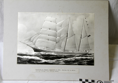
This photograph is a copy of an original painting by the Australian marine artist A V Gregory (1867-1957), also known as Arthur Victor Gregory. Gregory lived and worked in South Melbourne. He took over the Gregory Studio owned by his father, George Frederick Gregory, painting actively between 1899 and 1932. He usually signed his works as ‘A V Gregory’. Some of his original works have been sold for thousands of dollars. The barque "La Bella" was built in 1893 in Norway. On 31st October she commenced her maiden voyage. After six voyages, the vessel was offered for sale in Hamburg. After much negotiation, she was sold on December 1900 for £3,600 to Mr D C Turnbull and sailed back to New Zealand. The "La Bella" was primarily used on the Australian-New Zealand run, her cargo being timber, coal and produce. In October 1904, she ran aground at Owhira bay, New Zealand. The vessel was subsequently refloated. In November 1904, the "La Bella" attempted to enter Warrnambool Harbour without a pilot aboard. The vessel struck Annabella reef and many members of the crew perished. The "La Bella" captain was later charged and found guilty of negligence. In 1905 he was charged and tried for manslaughter. He died of a heart attack later that year and is buried in an unmarked grave at Melbourne General Cemetery.The detailed image of the vessel depicted in this photograph shows one of the many sail and steam vessels painted by the renowned Victorian marine artist A V Gregory, whose original works are highly valued today by marine collectors.Photograph of a painting of the three-masted sailing ship "La Bella" sailing through Port Phillip Heads. The original painting is by marine artist A V Gregory. A label is pasted below the photograph. The artist's signature is visible.Signed "GREGORY-01" Painted on the ship's bow "LA BELLA" Typed label "Painted by Gregory completed in 1901, showing the La Bella sailing through Port Phillip Heads'.flagstaff hill, flagstaff hill maritime museum and village, warrnambool, maritime museum, maritime village, great ocean road, shipwreck coast, la bella, d c turnbull, warrnambool harbour, lady bay -
 City of Moorabbin Historical Society (Operating the Box Cottage Museum)
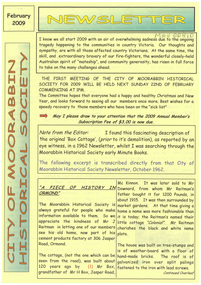
Newsletter, City of Moorabbin Historical Society Feb 2009, February 2009
The City of Moorabbin Historical Society was formed c 1960 by a group of Moorabbin residents who were concerned that the history of the area should be preserved. A good response to a call for items related to the historical area of Moorabbin Shire brought donations of a wide variety of artefacts which are now preserved by the current members of CMHS at Box Cottage Museum . Helen Stanley, Secretary of CMHS, began producing a Newsletter for members in April 2007 to provide current information and well researched items of historical interest.Helen Stanley has produced a bi-monthly Newsletter, 2007 - 2013, for the members of the City of Moorabbin Historical Society that contains well researched interesting historical items, notification of upcoming events, current advice from Royal Australian Historical Society , Museums Australia Victoria and activities of Local Historical Societies. The Newsletter is an important record of the activities of the CMHS. Tom Sheehy, past President of CMHS, was an Historian and Author of ‘Battlers Tamed the Sandbelt’. 2 x A4 paper printed on 3 sides Issue 10 of the bi-monthly, City of Moorabbin Historical Society Newsletter produced by Society member and Secretary, Mrs Helen Stanley in February 2009. The Victorian Bushfire tragedy around Marysville is still unfolding as this Newsletter is written. The first meeting for the year is February 22nd and subscriptions are due. An excerpt is transcribed from the City of Moorabbin Historical Society Newsletter October 1962, “A Piece of History in Ormond” by an unknown eyewitness author, describing the original “Box Cottage” situated in Mr J. Reitman’s cement products factory at 306 Jasper Road, Ormond prior to demolition. The current Editor gives information obtained from further recent research . An Article by Tom Sheehy, past President and Historian, February 1979 “The Vineyards of Moorabbin”. The ‘Brighton Estate” began when Henry Moor brought Vine cuttings from Camden NSW 1848 and they were productive after 3 years. Many Vineyards then appeared from Port Phillip Bay to East Boundary Road and produced 2/3 of the annual Victorian grape crop. Disease or insect caused failure in1858 and the land reverted to market gardens. A coloured photocopied photo of Box Cottage 2005. CITY of MOORABBIN HISTORICAL SOCIETY / FEBRUARY 2009 NEWSLETTERcity of moorabbin historical society, stanley helen, sheehy tom, melbourne, moorabbin, brighton, cheltenham, ormond, bentleigh, vineyards, fruit growing, vine diseases, winemaking, grapes, market gardeners, pioneers, early settlers, moorabbin shire, box cottage museum, dairy, port phillip bay, brighton estate, moor henry, cambden estate, reitman j., reitman w., cement, pottery, jasper road ormond, east boundary road brighton, dendy’s special survey 1851, point nepean road, south road brighton, thomas street brighton, north road brighton, county of bourke, box h., box william, bruton william, brighton brewery, parish of moorabbin, parish of prahran, markets, shingle roof, weather-board, downward mr., mckinnon -
 Port Melbourne Historical & Preservation Society
Film - Video Recording - Digital, I Wish I Had Been There, 28 Jul 2020
The Port Melbourne Historical and Preservation made history on the 28 July 2020 when, because of the COVID-19 pandemic, we hosted our first meeting via Zoom.Digital video recording of PMHPS meeting held via Zoom on 28 July 2020. Eight members spoke on the theme “I Wish I Had Been There …” Margaret BRIDE wishes she had there when Wilbraham LIARDET had ridden up and down Bay Street proclaiming the separation of Victoria from New South Wales. John MAY wishes he was there in 1937 when Port Melbourne and Williamstown Football Clubs swapped players. Sue LEONG wishes she was there in July, 1901 in front of the building where she now lives but previously was a stables and carrier’s business. David RADCLIFFE wishes he was there in March, 1924 when the HMS Hood and the HMS Repulse arrived in Port Melbourne. Beris CAMPBELL wishes she was there in 1974 at Arch TODD's Mayoral Ball at Port Melbourne Town Hall. Garry SMART wishes he was there for the Sandridge Council meeting held at the newly built court house on 23 August 1860. Helen BARRY wishes she was there at the Graham Street railway gates where her grandfather proposed to her grandmother. Lex JOHNSON wishes he was there on the last Saturday in August, 1946 when Port Melbourne took on Coburg at North Port Oval.margaret bride, wilbraham frederick evelyn liardet, wfe liardet, separation, john may, port melbourne football club, williamstown football club, sue leong, knight's transport, david radcliffe, hms hood, hms repulse, beris campbell, archibald (arch) todd, celebations - balls, gary smart, local government - municipal district of sandridge, court house, helen barry, lex johnston, coburg football club -
 Ballarat Tramway Museum
Photograph - Digital image Set of 9, Tony Smith, 19/09/1971 12:00:00 AM
Yields information about Ballarat Tramways and trams prior to the closure of the tramway system.Set of 9 digital images of Ballarat trams prior to closure, scanned from original slides by Tony Smith, 1971 prior to closure of the system. This set of slides appears to be the last day of operations - 19/9/1971 .1 - 40 south bound in Lydiard St Nth, at the Gregory St Loop. .2 - 40 after passing through the loop .3 - 42, north bound in Lydiard St. North at Macarthur St. .4 - 42 southbound at the Railway station level crossing with the Kennedy Murray Pty Ltd General Carriers building at the station yard in the background. .5 - 42 southbound in Lydiard St North after crossing the railway - taken from the signal box (B) with Reids Palace in the background and the Provincial Hotel. .6 - 35 northbound after passing through the level crossing. .7 - bogie tram crossing the tracks with Ballarat Railway Station in the background. .8 - bogie tram entering the double track section in Lydiard St with Reids Palace in the background. Note the new bus stop bay. .9 - 35 and another bogie in Sturt St, with the Town Hall, Golden Star Chinese Cafe and Georges Fish & Chip shop in the background.trams, tramways, lydiard st nth, gregory st, level crossings, ballarat railway station, sturt st, closure, tram 40, tram 42, tram 35 -
 Phillip Island and District Historical Society Inc.
Photographs, Kodak, c 1948
A collection of photographs donated by Rhonda McInnes (nee Closs) from her father, Don Closs 's collection. Taken whilst her parents were courting and had a trip to Phillip Island.327-01 - Black & White photograph of Westernport with Cowes Ferry and other ships in the background. 327-02 - Black & White photograph of Cowes Pier looking towards Cowes. 327-03 - Black & White photograph of the Hollydene Guest House with people standing at the front gate. 327-04 - Black & White photograph of the Cowes Vehicular Ferry arriving/departing from the Cowes Pier. 327-05 - Black & White photograph of the Proprietor of the Hollydene Guest House with Janet ? 327-06 - Black & White photograph of The Nobbies, Phillip Island. 327-07 - Black & White photograph of The Nobbies with Seal Rocks in the distance. 327-08 - Black & White photograph of The Nobbies with Janet ? in the foreground. 327-09 - Black & White photograph of Churchill Island from Phillip Island. 327-10 - Black & White photograph of the Phillip Island Suspension Bridge taken from San Remo. 327-11 - Black & White photograph of Bert West and his bus with two passengers getting onto the bus. the nobbies, cowes pier phillip island, westernport, cowes car ferry, hollydene guesthouse cowes phillip island, churchill island, phillip island suspension bridge, bert west -
 Federation University Historical Collection
Plan, Ballarat Railway Plan, 1888, 27/02/1888
.1) Copy of a Ballarat Railway Plan, running along Belford Street, from the Engineer in Chief's Office, Railway Department. It shows bridges, diversions, culverts and the following streets: Joseph Street, Lal Lal Street, Clayton Street, Belford Street, Rodier Street, trench Street, Stawell Street, Rodier Street, Belford Street, George Street, Eureka Street, Queen Street, Otway Street, Scott Parade, Ross Street, Chamberlain Street, Victoria Street, Water Street. Allotments owned by Tulloch and McLaren, J. Wilson, J. McCarthy, Mrs P. Glynn, E. Ratcliffe, soap works, Orphan Asylum .2) Copy of a plan relating to the construction of the Ballarat Railway Line. It includes shafts for the following companies: South Extended Co, Black Hill; Parade Co.; Black Hill Co.; Spanhake Co. Shaft; Black Hill South Co.; Wellingtonia Gigantiea Co., and the old workings of the Welllingtonia Gigantea Co,ballarat railway plan, belford street, lal lal street, clayton street, rodier street, trench street, south extended co., black hill, parade co., spanhake co. shaft, black hill south co., wellingtonia gigantiea co, railway -
 Bendigo Historical Society Inc.
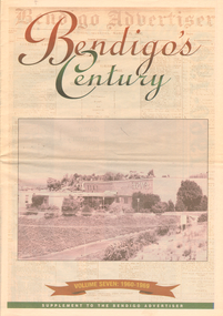
Newspaper - LONG GULLY HISTORY GROUP COLLECTION: BENDIGO'S CENTURY VOLUME SEVEN: 1960 - 1969
Supplement to the Bendigo Advertiser, December 15, 1999 Volume Seven: 1960-1969 titled Bendigo's Century. The front has a photo of the BCV 8 Studio. Contains photos and local news, council matters, planning, Who's Who, Weather, Sport and Business and some Advertisements. Photos include Early stages in the construction of the Eppalock tower and bridge pillars, Christine Wiseman, TV8's first news reader Ron Alderton, Dr Albert L Beischer, Advertiser buiding, fire at the Advertiser building, Oscar Flight, Bendigo Town Hall, William Basil Ashman, Lake Eppalock, Premier Henry Bolte, Que O'Hoy, Sandhurst Guest House, The Lyric Theatre, E C Thompson, The elm tree in Market Square, Leslie Galvin, The original Myer Store, The Joss House, Sidney Myer, Bendigo Police Barracks, Bunratty Castle, Albert Vivian Gray, The Victoria Hill site, Architects drawing of the new council administrative offices and Noel Beaton MHR.bendigo, history, long gully history group, the long gully history group - bendigo's century volume seven: 1960 - 1969, bendigo advertiser, bcv 8, eppalock dam, premier henry bolte, the criterion hotel, mccarthy family, teachers training college, bendigo original teachers college, long gully state school, stramit, bendigo university site committee, mrs christine wiseman, bendigo city council, the broadcasting control board, general television pty ltd, bendigo central victoria telecasters pty ltd, mr davidson, bennett's arcade, woolworth's, white hills swimming pool, herb elliott, sailor's guide, toni riley pharmacies, rising sun hotel, ron alderton, dr albert l beischer, channel 8, melbourne herald, 3bo, bendigo advertiser officeslyceum theatre, junior technical school white hills, mount alvernia hospital, most reverend dr b d stewart, sisters of the franciscan missionaries of the divine motherhood, lazarus family, bendigo's tramways, state electricity commission, george pethard, lance pethard, bendigo advertiser fire 29/7/1962, riverine herald, the herald and weekly times, bendigo art gallery, oscar flight, hollands foundry, eaglehawk u.f.s. dispensary, gillies famous pies, william basil ashman, golden gate hotel, grieves family, bendigo town hall, mr r r anderson, mr e h brown, cr neville oliver, cr tom flood, traffic commission, lansell family, abev-1, bendigo ordnance factory, actu, bendigo trades hall council, the ramsay report, bendigo benevolent home, bendigo home and hospital for the aged, princess theatre, amoco, lake eppalock, bendigo training prison, bendigo police station lock-up, shamrock hotel, rifle brigade hotel, hopetoun hotel, anz bank, marong shire offices, sir rohan delacombe, st paul's church, que o'hoy, waldron family, windermere hotel, aids & appliance shop, anne caudle centre, e c thompson, mayfair hams, sandhurst guest house, lyric theatre, chinese joss house, ordnance factory, sir john jenson, bridge street chinese quarter, bendigo city hall, cr r f turner, cr tom flood, victorian inland meat authority, new zealand insurance co, mrtropolitan security service, bendigo easter fair society, golden square high school, eaglehawk high school, bendigo technical college, mr ralph w birrell, bendigo fountain plaza, the bethlehem home for the aged, dick hazeldene, victorian egg board, bendigo united cricket club, south bendigo united cricket club, western mining corporation, les priest, alexandra fountain, bendigo advertiser, cr w cambridge, bendigo council, eaglehawk council, strathfieldsaye shire, huntly shire, marong shire, david thomas, senator john gorton, bendigo's college of advanced education, bank of new south wales, harp and shamrock hotel, the honorable leslie william galvin, kurmala, cain government, hanro knitting mills, myer store, sidney myer, davey brothers grocery store, national trust, myer emporium, myer's ltd, cox bros (australia) ltd, dame merlyn myer, baillieu myer, frank greenaway, institute of technology, gas & fuel corporation, bendigo railway station, anz bank, city family hotel, tab branch, senior constable alfred herbert wright, senior constable allan raymond brown, victorian football league, bendigo police barracks, camp hill state school, state electricity commission, the country party, the labor party, transport regulation board, stuart anderson, grose family, jean theodore de ravin, kyneton shire, sir william mcdonald, mines department, the loddon hospitals region group laundry and central linen service, kevin wynne, albert vivian gray, bradford cotton mills ltd, bradmill industries ltd, victoria hill, bendigo and district tourist association, professor brian lewis, melbourne university, victorian chinese community, loong, sun loong, stafford ellinson, coles' store, north deborah mining company nl, noel beaton mhr, durham ox hotel, taylor family -
 Ballarat Tramway Museum
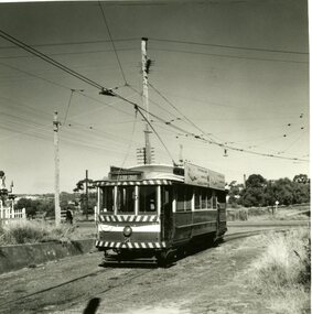
Photograph - Digital image Set of 10, Tony Smith, 1971
Yields information about Ballarat Tramways and trams prior to the closure of the tramway system.Set of 10 digital images of Ballarat trams prior to closure, scanned from original slides by Tony Smith, 1971 prior to closure of the system. .1 - 11 arriving at Gardens Loop, tram has destination of Mt Pleasant, advert for Twin Lakes and SEC Briquettes. In the background is the Gardens Kiosk building. .2 - 11 at Gardens Loop .3 - 11 in Victoria St, crossing the Eureka line rail bridge. .4 - 43 and another bogie tram sitting on 1 road at the depot. .5 - 27 derailed at the depot, in Wendouree Parade - derailed all wheels. .6 - ditto .7 - 33 coupled up to 27, to pull it back onto the track. Driver adjusting the pole. Tram has an Eureka and SEC roof advertisement. .8 - 27 in Wendouree Parade, showing depot, just to the east of the depot. .9 - 33 in bound in Drummond St North at the Mill St Loop. .10 - 33 in bound in Victoria St, has Gardens via Drummond St Nth destination.trams, tramways, wendouree parade, gardens loop, victoria st, depot, derailments, drummond st nth, mill st loop, tram 11, tram 43, tram 27, tram 33 -
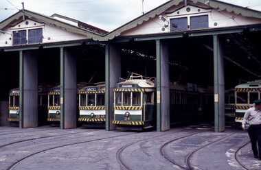 Ballarat Tramway Museum
Slide - 35mm slide/s - set of 11, Eldon Hogan, mid 1960's to early 1970's
Set of 11 Agfa Plastic mounted slides - from the Eldon Hogan collection - possibly on an ARE Bendigo tours - mid 1960's (black destination rolls) and late 1960's or early 1970's. Scanned on the Canon scanner at the depot 15/12/1971 at the time of the installation of the scanner. .1 - front of depot -26, 19, 24, 29 and 28 amongst those present. .2 - ditto .3 - 24 departing depot .4 - 26 at Eaglehawk .5 - No. 5 turning from Pall Mall into Mitchell St with town hall in background. .6 - No. 5 using crossover in Mitchell St - with Maples, CBA Bank, Astor, Homecrafts, Roger David shops or signs in the background. .7 - ditto .8 - bogie car at Charing Cross with the Fountain Plaza shopping centre in the background. .9 - Charing Cross, with the fountain in the foreground, The Beehive and three trams in the view. .10 - No. 24 outbound, Golden Square line crossing the bridge over the creek, adjacent to the discovery of Gold Monument. .11 - ditto. tramways, trams, bendigo, eaglehawk, depot, charing cross, golden square, tram 26, tram 19, tram 24, tram 29, tram 28, tram 26, tram 5 -
 Wodonga & District Historical Society Inc
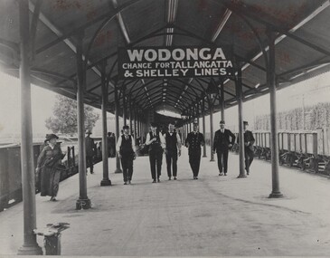
Photograph - Fred Rochow Railways Collection - Wodonga Railway Station, C. 1916 - 1930
The Fred Rochow Railways Collection incorporates photos related to the operation of the Wodonga Railway Station including different types of trains and railways staff C. 1930 – 1990. It was donated to the Wodonga Historical Society by Fred Rochow, a railwayman who spent many years based in Wodonga. He joined the Victorian Railways on 17th June l947 and retired in 1988. For some time, he was a member of the Australian Federated Union of Locomotive Enginemen and served a term as a member of the Trades Hall Council. He had an extensive knowledge of the struggles that took place to achieve better conditions for railway workers. Fred worked for many years as a fireman and then worked his way up the ranks to driver, experiencing many changes from the days of steam locomotives through to diesel trains, locomotives and even the modern XPT train. He worked throughout Victoria at different stages of his career, with his final working years focused on the northeast of Victoria and the Albury to Melbourne line. After his retirement, Fred continued to share his love of steam miniature trains with the community.This collection has local and statewide significance as it captures images of trains, locomotives and personnel who operated the railway services in Wodonga and throughout Northeast Victoria. The railways played a critical role in opening up Victoria and connecting Australia for trade, business, social communication and transport.Railway men walking along the Wodonga Railway Platform. The sign overhead advises of changes to the Tallangatta and Shelley lines. Cudgewa Line -The Cudgewa railway line opened in stages between 1889 and 1921. The first section from Wodonga to Huon opened on 10 September 1889. It was extended to Bolga on 18 July 1890, Tallangatta on 24 July 1891 and then to Shelley on 13 June 1916. Shelley was the highest station in Victoria. It extended further on to Beetomba on 10 April 1919 and finally reached Cudgewa on 5 May 1921. The line had 1 in 30 grades and trestle bridges that have been heritage listed. In 1919, the line was used to carry materials for the construction of Hume Weir, and three years later a spur line connecting Ebden to the weir was opened. In the 1960s, Cudgewa became the railhead of materials for the Snowy Mountains Scheme. The last passenger service from Wodonga to Tallangatta ran on 30 September 1961. The turntable and passenger platform at Cudgewa were abolished in 1976. On sign hanging overhead "WODONGA/ CHANGE FOR TALLANGATTA AND SHELLEY LINES"railways wodonga, fred rochow, wodonga railwaymen, cudgewa rail line, wodonga railway station -
 Falls Creek Historical Society
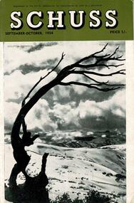
Journal - Schuss Vol. 20. No. 7 September - October 1954
Schuss was advertised as Victoria’s Official Ski Journal It was issued monthly from 1935 to 1961 except during the war when summer issues covered two months. This continued after the war, but it averaged 10 issues annually over its 25 year life. Schuss was published by the Ski Club of Victoria which had a membership of 38 Ski Clubs and demanded to be recognised as the prime authority on skiing in the state. The other 30 ski clubs with 85% of the members disagreed and the politics of skiing became heated. These clubs formed the Federation of Victorian Ski Clubs with their own journal, Ski Horizon. With the establishment of the Victorian Ski Association, Ski-Horizon published its last issue in Nov - Dec. 1955 and the role of the official journal was fully taken over by “Schuss”. This item is significant because it contains stories, images and information documenting the development of the ski industry in Victoria.The journal features stories and events chronicling developments in Victoria and internationally. Items related to the Falls Creek Area in this issue include:- Cover - Features a photo of Skeleton Snowgum at Mt. Hotham Page 233 - Lower image taken by W. L. Godfrey "On the slope of Mt. McKay, Bogong High Plains, showing Mt. Bogong in the background." Page 234 Top image Photo: H. S. Gibbs On the road to Falls Creek, Mt. Arthur in the background. Lower image: Photo- L. Coote SYDNEY HARBOUR BRIDGE, ROCKEY VALLEY, BOGONG HIGH PLAINS. This structure, well known to skiers who frequent the Plains, has now collapsed, having succumbed to the ravages of many years of use. The structure was erected by Joe Holston with the aid of a few simple tools. It's rustic craftsmanship has always been admired and served to remind skiers of the kindliness and good nature of Joe, who befriended many skiers who visited the High Plains in past years.schuss journal, the ski club of victoria, mt kckay, bogong high plains -
 Melbourne Tram Museum
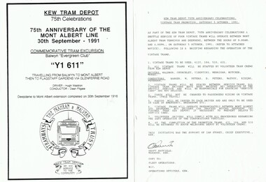
Souvenir - Event Materials, Public Transport Corporation (PTC), "Kew Tram Depot 75th Celebrations", 1991
Set of 6 A4 sheets of event materials associated with the "Kew Tram Depot 75th Celebrations", Oct. 1991. .1 - 75th anniversary of the Mont Albert Line, Y1 611 - Balwyn Evergreen Club, 30/9/1991, driver Hugh Waldron and Conductor Dean Filgate. .2 - Vintage Tram Promotion - 56/10/1991, trams 611, 104, 510 and 431. Gives instructions and crews for the event. .3 - Open Day - 8/12/1991 - proposal for the event and what was planned. .4 -HTT 75th Anniversary celebrations - 24/11/2991 - timetable for special trams running between Camberwell Depot and Princes Bridge. Lists crews. .5 - Advertisement for "Kewriosity - November 1991" advising of the Open Day at Kew and the horse tram rides. Has a photo of a Kew horse tram. Sponsored by a cleaning supply company. .6 - Summary of events for the 75th. Promotional events, including A231, 611 and 380, dates, internally events and related events.trams, tramways, kew depot, anniversary, events, mont albert, htt, vintage trams, horse trams, tram 231, tram 611, tram 380, tram 104, tram 510, tram 431 -
 Melbourne Tram Museum
Slide - Set of 4, Vic Solomons, Jun. 1970
Slide - set of 4 - 35mm - Kodachrome cardboard mounts. .1 - Tram 808 at the Spencer St stop at the corner of Bourke St with Spencer St Station in the background. Note the route and destination - at the time when North Balwyn and Burwood Routes were combined on Sundays am and evening - and passengers changed at Hawthorn Bridge. Route 74. Has a Fosters Lager advertisement. .2 - As above, tram approaching the stop with the Spencer St station car park in the background. .3 - tram 1005 leaving the Bourke St terminus, taken after .4 .4 - tram 1005 at the Bourke St terminus with tram 838 crossing in the background, has the Station building, Carlyon's Hotel and the Tramways Building. Note the Bundy clock, tram stop signage and safety zone. Route 96. The grey box by the Bundy Clock is thought to be a correspondence box for the satchels that were transported between the depots and head office. Photographed by Vic Solomons June 1970 (based on date stamped on slide)trams, tramways, bourke st, spencer st, railways, stations, route 74, north balwyn, burwood, route 96, letters, mails, tram 808, tram 1005, tram 838 -
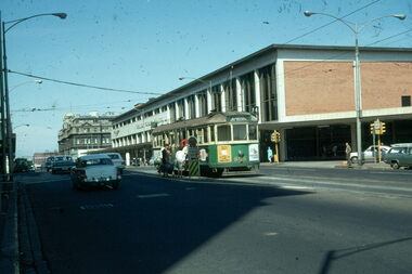
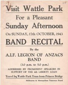 Melbourne Tram Museum
Document - Notice, Report, Melbourne & Metropolitan Tramways Board (MMTB), "Wattle Park Band Recital", Oct. 1943
Set of six documents associated with a Wattle Park band recital by the AIF Legion of Anzacs band on Sunday 17 October 1943 in support of the 4th Liberty Loan. .1 - printed poster advertising the afternoon and travel by tram from Princes Bridge. .2 - duplicated notice from the Assistant Manager to Depots dated 13/10/1943 about the bus to be used to transport band members from Elizabeth St to Wattle Park - Central Bus Depot - notes the bus had been specially prepared for the event. .3 - typed notice from the District Traffic Superintendent to Hawthorn and Camberwell depots about special trams for the event and arrangements for conductors. Signed by J. M. Harry rubber stamp. .4 - hand written in blue indelible pencil on ruled paper, the table for the special cars for the event. .5 - hand written notes on heavy card of timing and loading on trams at Glenferrie Road. Signed R. Whitelaw. .6 - ditto for loading ex Wattle Park loop - signed by A? Cameron.1 - has a pencil inscription "158" in the top left hand corner. .3 - has a pencil note "Copy sent Hawt Insp with table" along the bottom edge.trams, tramways, mmtb, world war 2, wattle park, events, bands, buses, hawthorn depot, camberwell depot -
 Flagstaff Hill Maritime Museum and Village
Glass
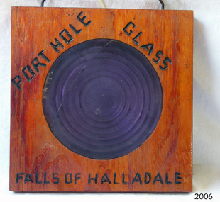
Falls of Halladale The Falls of Halladale was a four-masted sailing ship built-in 1886 in Glasgow, Scotland, for the long-distance cargo trade and was mostly used for Pacific grain trade. She had a sturdy construction built to carry maximum cargo and able to maintain full sail in heavy gales, one of the last of the ‘windjammers’ that sailed the Trade Route. She was one of the first vessels to include fore and aft lifting bridges, which kept the crew safe and dry in as they moved around the decks in stormy conditions. She was owned by Wright, Breakenridge & Co of Glasgow and was one of several Falls Line ships, all of which were named after waterfalls in Scotland. On 4th August 1908, with new sails, 29 crew, and 2800 tons of cargo, the Falls of Halladale left New York, bound for Melbourne and Sydney via the Cape of Good Hope. The cargo on board was valued at £35,000 and included 56,763 tiles of American slate roofing tiles, 5,673 coils of barbed wire, 600 stoves, 500 sewing machines, 6,500 gallons of oil, 14,400 gallons of benzene, plumbing iron, 117 cases of crockery and glassware and many other manufactured items. The Falls of Halladale had been at sail for 102 days when, at 3 am on the of 14th November 1908, under full sail in calm seas with a six knots breeze behind and misleading fog along the coast, the great vessel rose upon an ocean swell and settled on top of a submerged reef near Peterborough on south-west Victoria’s coast. The ship was jammed on the rocks and began filling with water. The crew launched the two lifeboats and all 29 crew landed safely on the beach over 4 miles away at the Bay of Islands. The postmistress at Peterborough, who kept a watch for vessels in distress, saw the stranding and sent out an alert to the local people. A rescue party went to the aid of the sailors and the Port Campbell rocket crew was dispatched, but the crew had all managed to reach shore safely by the time help arrived. The ship stayed in full sail on the rocky shelf for nearly two months, attracting hundreds of sightseers who watched her slowly disintegrate until the pounding seas and dynamiting by salvagers finally broke her back, and her remains disappeared back into deeper water. The valuable cargo was largely lost, despite two salvage attempts in 1908-09 and 1910. Further salvage operations were made from 1974-1986, during which time 22,000 slate tiles were recovered with the help of 14 oil drums to float them, plus personal artefacts, ship fittings, reams of paper and other items (a list of items held at Flagstaff Hill Maritime Village is included below). The Court of Marine Inquiry in Melbourne ruled that the foundering of the ship was entirely due to Captain David Wood Thomson’s navigational error, not too technical failure of the Clyde-built ship. The shipwreck is a popular site for divers, about 300m offshore and in 3 – 15m of water. Some of the original cargo can be seen at the site, including pieces of roof slate and coils of barbed wire. The Falls of Halladale shipwreck is listed on the Victorian Heritage Register (No. S255). She was one of the last ships to sail the Trade Routes. She is one of the first vessels to have fore and aft lifting bridges. She is an example of the remains of an International Cargo Ship and also represents aspects of Victoria’s shipping industry. The wreck is protected as a Historic Shipwreck under the Commonwealth Historic Shipwrecks Act (1976).Porthole glass secured in wood, with a crack in the glass. Writing on wood "porthole Glass Falls of Halladale."Burnt into the wood are the words "porthole Glass Falls of Halladale."falls of halladale, wright, breakenridge & co of glasgow, californian blue roof slate, warrnambool, shipwrecked-coast, flagstaff-hill, flagstaff-hill-maritime-museum, maritime-museum, shipwreck-coast, flagstaff-hill-maritime-village, shipwrecked-artefact, porthole glass -
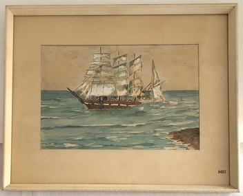 Flagstaff Hill Maritime Museum and Village
Painting - Watercolour painting, Early 20th century
FALLS of HALLADALE - History The Falls of Halladale was a four-masted sailing ship built-in 1886 in Glasgow, Scotland, for the long-distance cargo trade and was mostly used for Pacific grain trade. She had a sturdy construction, built to carry maximum cargo and maintain full sail in heavy gales. She was one of the last of the ‘windjammers’ that sailed the Trade Route and one of the first vessels to include fore and aft lifting bridges, which kept the crew safe and dry in as they moved around the decks in stormy conditions. She was owned by Wright, Breakenridge & Co of Glasgow and was one of several Falls Line ships, all of which were named after waterfalls in Scotland. On 4th August 1908, with new sails, 29 crew, and 2800 tons of cargo, the Falls of Halladale left New York, bound for Melbourne and Sydney via the Cape of Good Hope. The cargo on board was valued at £35,000 and included 56,763 tiles of American slate roofing tiles, 5,673 coils of barbed wire, 600 stoves, 500 sewing machines, 6,500 gallons of oil, 14,400 gallons of benzene, plumbing iron, 117 cases of crockery and glassware and many other manufactured items. The Falls of Halladale had been at sail for 102 days when, at 3 am on the of 14th November 1908, under full sail in calm seas with a six knots breeze behind and misleading fog along the coast, the great vessel rose upon an ocean swell and settled on top of a submerged reef near Peterborough on south-west Victoria’s coast. The ship was jammed on the rocks and began filling with water. The crew launched the two lifeboats and all 29 crew landed safely on the beach over 4 miles away at the Bay of Islands. The postmistress at Peterborough, who kept a watch for vessels in distress, saw the stranding and sent out an alert to the local people. A rescue party went to the aid of the sailors and the Port Campbell rocket crew was dispatched, but the crew had all managed to reach shore safely by the time help arrived. The ship stayed in full sail on the rocky shelf for nearly two months, attracting hundreds of sightseers who watched her slowly disintegrate until the pounding seas and dynamiting by salvagers finally broke her back, and her remains disappeared back into deeper water. The valuable cargo was largely lost, despite two salvage attempts in 1908-09 and 1910. Further salvage operations were made from 1974-1986, during which time 22,000 slate tiles were recovered with the help of 14 oil drums to float them, plus personal artefacts, ship fittings, reams of paper and other items (a list of items held at Flagstaff Hill Maritime Village is included below). The Court of Marine Inquiry in Melbourne ruled that the foundering of the ship was entirely due to Captain David Wood Thomson’s navigational error, not to technical failure of the Clyde-built ship. The shipwreck is a popular site for divers, about 300m offshore and in 3 – 15m of water. Some of the original cargo can be seen at the site, including pieces of roof slate and coils of barbed wire.The Falls of Halladale shipwreck is listed on the Victorian Heritage Register (No. S255). She was one of the last ships to sail the Trade Routes. She is one of the first vessels to have fore and aft lifting bridges. She is an example of the remains of an International Cargo Ship and also represents aspects of Victoria’s shipping industry. The wreck is protected as a Historic Shipwreck under the Commonwealth Historic Shipwrecks Act (1976).Watercolour painting behind glass, framed in the Art Deco style - stippled cream painted wood. There are some age marks under the glass. The painting depicts the Falls of Halladale with its stern under water. The back of the painting contains facts about the shipwreck handwritten in a similar style to the artist’s signature. The artist’s signature is not clear enough to identify. Inscription on the back: Pasted on typed text: Peterborough Handwriting: Falls of Halladale 2085 tons 4 masted iron barque wrecked Saturday November 14th 1908 Captain Thomson crew of 28 !st mate F Pearson 2nd mate T Griffinflagstaff hill, warrnambool, flagstaff hill maritime museum & village, maritime museum, maritime village, shipwreck coast, 1908 shipwreck, falls of halladale, peterborough, peterborough shipwreck, great ocean road, captain thomson, 1880s sailing ship, cargo vessel, 1st mate f pearson, 2nd mate t griffin, watercolour painting -
 Flagstaff Hill Maritime Museum and Village
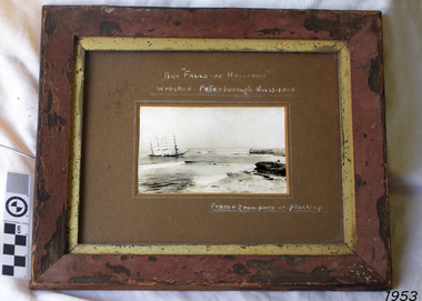
Photograph - Vessel, Sailing Ship, Falls of Halladale, After 13-11-1908
Falls of Halladale The Falls of Halladale was a four-masted sailing ship built-in 1886 in Glasgow, Scotland, for the long-distance cargo trade and was mostly used for Pacific grain trade. She had a sturdy construction built to carry maximum cargo and able to maintain full sail in heavy gales, one of the last of the ‘windjammers’ that sailed the Trade Route. She was one of the first vessels to include fore and aft lifting bridges, which kept the crew safe and dry in as they moved around the decks in stormy conditions. She was owned by Wright, Breakenridge & Co of Glasgow and was one of several Falls Line ships, all of which were named after waterfalls in Scotland. On 4th August 1908, with new sails, 29 crew, and 2800 tons of cargo, the Falls of Halladale left New York, bound for Melbourne and Sydney via the Cape of Good Hope. The cargo on board was valued at £35,000 and included 56,763 tiles of American slate roofing tiles, 5,673 coils of barbed wire, 600 stoves, 500 sewing machines, 6,500 gallons of oil, 14,400 gallons of benzene, plumbing iron, 117 cases of crockery and glassware and many other manufactured items. The Falls of Halladale had been at sail for 102 days when, at 3 am on the of 14th November 1908, under full sail in calm seas with a six knots breeze behind and misleading fog along the coast, the great vessel rose upon an ocean swell and settled on top of a submerged reef near Peterborough on south-west Victoria’s coast. The ship was jammed on the rocks and began filling with water. The crew launched the two lifeboats and all 29 crew landed safely on the beach over 4 miles away at the Bay of Islands. The postmistress at Peterborough, who kept a watch for vessels in distress, saw the stranding and sent out an alert to the local people. A rescue party went to the aid of the sailors and the Port Campbell rocket crew was dispatched, but the crew had all managed to reach shore safely by the time help arrived. The ship stayed in full sail on the rocky shelf for nearly two months, attracting hundreds of sightseers who watched her slowly disintegrate until the pounding seas and dynamiting by salvagers finally broke her back, and her remains disappeared back into deeper water. The valuable cargo was largely lost, despite two salvage attempts in 1908-09 and 1910. Further salvage operations were made from 1974-1986, during which time 22,000 slate tiles were recovered with the help of 14 oil drums to float them, plus personal artefacts, ship fittings, reams of paper and other items (a list of items held at Flagstaff Hill Maritime Village is included below). The Court of Marine Inquiry in Melbourne ruled that the foundering of the ship was entirely due to Captain David Wood Thomson’s navigational error, not too technical failure of the Clyde-built ship. The shipwreck is a popular site for divers, about 300m offshore and in 3 – 15m of water. Some of the original cargo can be seen at the site, including pieces of roof slate and coils of barbed wire. The Falls of Halladale shipwreck is listed on the Victorian Heritage Register (No. S255). She was one of the last ships to sail the Trade Routes. She is one of the first vessels to have fore and aft lifting bridges. She is an example of the remains of an International Cargo Ship and also represents aspects of Victoria’s shipping industry. The wreck is protected as a Historic Shipwreck under the Commonwealth Historic Shipwrecks Act (1976).Photograph of the wrecked ship, the Falls of Halladale, sails still flying. The ship was wrecked at Peterborough on Nov 13, 1908. The outer frame is made from a piece of planking. Handwritten inscriptions in white ink on the top of the matt board, and on the lower right.BQE "Falls of Halladale" "Wrecked. Peterborough. Nov 13. 1908" "Frame. from piece of planking."flagstaff hill, warrnambool, shipwrecked-coast, flagstaff-hill, flagstaff-hill-maritime-museum, maritime-museum, shipwreck-coast, flagstaff-hill-maritime-village, shipwreck, photograph, falls of halladale, planking frame -
 Bendigo Historical Society Inc.
Document - LONG GULLY HISTORY GROUP COLLECTION: THE BENDIGO POST OFFICE
Article titled The Bendigo Post Office, compiled by L C Bennetts. Mentioned is the history of the Bendigo Post Office and postmarks, some information on mining, Bendigo foundries, Underground connections of mines, expenses and shaft sinking costs. Also mentioned is Bendigo and Eaglehawk - 60 years ago and the role the pubs played in daily living. They were where theatres, concerts and dances were held, and the meeting rooms for clubs and lodges, even church benefits. Listed is a number of Bendigo hotels. Some even had a few names. Names of the pubs are: The Freemasons, The Courthouse, The Commercial Law Courts, The Hamburg, The European, The Prince Bismark, The Lord Kitchener, The Bendigo, The Rosalind Park, The Showgrounds, Atheneum Club, Olivers, Bridge Hotel, Bourkes, The Globe, The Hibernia, Albert, Albion, Abbotts, Australian, Belvidere, Beehive, British Queen, Black Eagle, British and American, Brian Boru, Bakers Arms, Butchers Arms, Brick Layers Arms, Bull and Mouth, Cresent, Clarence, Back Creek Bridge, Cape Clear, Crooked Billet, Cambridgeshire Arms, Camp, Coach and Horses, Cricketers Arms, Diggers Rest, Ellesmere, Five Lions, Franklyn, Golden Square, Golden Gate, Golden Gully, Golden Age, Golden Vine, Gumtree, Glasgow Reef, Great Britain, Haymarket, Daniel O'Connell, Half Way House, Fleece Inn, Ironbark, Johnsons Reef, Lancashire, Live and Let Live, Manchester Arms, Gold Mines, Metropolitan, Crown, National, New Chum, Honeysuckle Street, Pavilion, Napier Arms, Quartz Miners Arms, Retreat Inn, Rainbow, Rose of Australia, Lake View, Robin Hood, Fountain, Southern Cross, Bath, Berlin, Spring Gully, Star, Sir Charles Hotham, Silvermines, Royal Oak, Suburban, Town Hall, Temperance, Ship Inn, View Point, View Bend, Victoria, Exchange, American, Arcade, Belfast, All Nations, Union, United Kingdom, Union Jack, Westend, Washington, Waterloo, Wellington, Whitehorse, Wheat Sheaf, Yorkshire, Niagra and Noahs Ark.bendigo, history, long gully history group, the long gully history group - the bendigo post office, l c bennetts, mt alexander post office, porcupine inn, cenotaph, pike or pyke, baby health centre, sandhurst post office, government survey office, queen elizabeth oval, sandhurst trustees company, mr h b briston, savings bank, telegraph office, the sub-treasury, sir henry brougham lock kcb, sir john nimmo mla, prince of wales group of mines, the new prince of wales, eaglehawk golf links, new prince of wales no 2, the whip and jersey, mines department, lansell's big 180, new chum and victoria mine and battery, new chum railway, koch's pioneer, south new moon, catherine reef united, new moon, the virginia, south bell vue, central nell gwynne, north nell gwynne, miner's phthisis, hercules engine house, ironbark, new chum syncline, hercules energetic, roberts & sons, harkness & co, horwoods, great southern, ulster, carlisle, lansells big 180, victoria quartz, new st mungo, duchess tribute, south devonshire, hopewell mine, saxby mine, mcnair & co, shamrock, mr king, burke and wills expedition, sandhurst hotel, courthouse, hiberian, the freemasons, the courthouse, the commercial law courts, the hamburg, the european, the prince bismark, the lord kitchener, the bendigo, the rosalind park, the showgrounds, atheneum club, olivers, bridge hotel, bourkes, the globe, the hibernia, albert, albion, abbotts, australian, belvidere, beehive, british queen, black eagle, british and american, brian boru, bakers arms, butchers arms, brick layers arms, bull and mouth, cresent, clarence, back creek bridge, cape clear, crooked billet, cambridgeshire arms, camp, coach and horses, cricketers arms, diggers rest, ellesmere, five lions, franklyn, golden square, golden gate, golden gully, golden age, golden vine, gumtree, glasgow reef, great britain, haymarket, daniel o'connell, half way house, fleece inn, ironbark, johnsons reef, lancashire, live and let live, manchester arms, gold mines, metropolitan, crown, national, new chum, honeysuckle street, pavilion, napier arms, quartz miners arms, retreat inn, rainbow, rose of australia, lake view, robin hood, fountain, southern cross, bath, berlin, spring gully, star, sir charles hotham, silvermines, royal oak, suburban, town hall, temperance, ship inn, view point, view bend, victoria, exchange, american, arcade, belfast, all nations, union, united kingdom, union jack, westend, washington, waterloo, wellington, whitehorse, wheat sheaf, yorkshire, niagra, noahs ark -
 Ballarat Tramway Museum
Photograph - Colour Photograph/s - set of 25, Austin Brehaut, 7/04/2000 12:00:00 AM
Yields information about various locations in Ballarat in March 2000 for comparison with previous photographs.Set of 25 colour photographs taken by Austin Brehaut on 7 April 2000 showing various locations that Ballarat trams once ran in, for use in a BTM presentation, named "Ballarat Past and Present" at the COTMA 2000 Ballarat Conference. All on Fujicolour Crystal Archive Paper. On rear in blue ink is the date, location and where relevant a reference number to photo locations that the author of the presentation had requested. Letter from Austin, filed with the worksheet for Reg. Item 1772. 1773.1 - Base Hospital, Cnr Drummond St. North and Mair St. .2 - Hospital Corner - Base Hospital Along Drummond St. North .3 - St John of God Hospital, cnr Mair and Drummond St. Nth. .4 - Hospital Corner, looking South East from Base Hospital .5 - Gardens at Loop (Wendouree Parade) .6 - Gardens Loop and Shelter .7 - Shelter at Gardens Loop .8 - Bridge Mall looking west .9 - Lower Victoria St. along Bridge St .10 - Railway crossing, Ballarat Station, with gates open .11 - Victoria St. hill facing west .12 - Railway crossing, Lydiard St. North .13 - Railway crossing, Ballarat Station, with gates closed .14 - Lydiard St. North terminus from cemetery .15 - Lydiard St. North at Macarthur St. .16 - Lydiard St. North at Sturt St facing South East - Post Office on left .17 - Looking north along Lydiard St at Sturt St .18 - Sturt and Lydiard Sts corner from Post Office .19 - Centre plantation Sturt St. looking east .20 - Sturt St. West near Ballarat and Clarendon College .21 - Sturt St. West facing west at Russell St. .22 - Victoria St. terminus .23 - Victoria St. terminus .24 - St Alipius Church, Victoria St. .25 - Junction of tramline and Phoenix foundry railway in Sturt St. at Armstrong St. (transferred from roadway) See Reg item 4645 and 4646 for the 2010 comparisons.See Aboveballarat, hospital corner, gardens loop, railway crossing, lydiard st. north, sturt st, phoenix foundry, armstrong st., victoria st., sturt st. west -
 Ballarat Tramway Museum
Photograph - Black & White Photograph/s set of 19, Mar. 1972
Set of 19 black and white prints, all 89mm square of Bendigo trams, date machine printed on print is "Mar 1972". 981.1 - Tram 21 at North Bendigo terminus, with level crossing in background. Has destination "Golden Square" and two SEC roof ads. 981.2 - tram 2? at Eaglehawk, with destination "Depot", two SEC roof ads and "Leo A. Hughes Photographer" on side of building in background. 981.3 - tram 2? at Eaglehawk, side on view. 981.4 - tram 26 at Quarry Hill terminus looking back into city. 981.5 - tram 7 en route to North Bendigo at the site of the Bridge St. loop. Has a Peters Ice Cream truck and Sandhurst Fruit Juices truck on right side of photograph. 981.6 - tram 2 at Quarry Hill terminus. 981.7 - tram 2? at one of the loops on the Eaglehawk line, inbound? 981.8 - bogie tram at Charing Cross with fountain in background. Side on view looking south. 981.9 -trams 7 and 21 on Golden Square/North Bendigo line with bogie tram in background, at Charing Cross. Same as item 972. 981.10 - bogie tram at Charing Cross - has buildings in south west corner in background, including Colonial Mutual Life and an advertisement for the Herald newspaper. 981.11 - trams 25, 7 and two other trams at Charing Cross. 981.12 - trams 2 and 26 and three others at Charing Cross. 981.13 - tram 25 at Golden Square terminus, with Rodda's Golden Square Hotel in the background. Tram showing destination of "Nth Bendigo" 981.14 - tram 24, showing "Special" on depot access track. Has two Johnnie Walker roof ads on side. 981.15 - as above, but tram on bridge outside depot. 981.16 - trams 25 and 28 at depot 981.17 - tram 24 showing "Special" on depot access track with a single truck car in background. 981.18 - trams 2 and 26 at Charing Cross. Has advertisements for "Armstrong Tyre Service" and "Cohn's drinks" on buildings in background. 981.19 - Bendigo 2 at location?, about to enter a loop or double track section. Has hotel in background. On rear of each photo in the top left hand corner is a print number 1 to 19 in ink and location notes, generally "Bendigo"trams, tramways, charing cross, bendigo, golden square, quarry hill, tram 2, tram 21, tram 7, tram 24, tram 26 -
 The Beechworth Burke Museum
Photograph
This photograph depicts four men standing near a large unidentified building. This building is the entrance to a deep lead mine shaft. There is a bridge entering the building, which was used to access the elevator to the shaft. Deep lead mining involved placing large shafts into the ground which miners use to access deeper locations in order to excavate the rocks in the search for lead. Deep lead mining was highly dangerous as roofs could cave in of the soil was loose. Therefore, this particular mining considered to be highly undesirable profession as many miners did not want to work long hours nor risk their lives in the search for lead. Indigo Shire was a large area where deep lead mining took place, and thus the landscape and environment was largely impacted by these mining businesses. The Indigo Shire grew in population and wealth in the early 1850s when people came into this location in the hopes of finding gold and making a fortune. Ultimately, the accessibility and availability of gold and precious metals decreased once the gold reserves dried up and alongside this, the large population moved away. The Ovens was also heavily impacted environmentally as deep mining resulted in the change in land formation.The search for gold is ingrained into the history of Victoria and therefore, images like this one which portray an open cut sluicing site can reveal important information for society and technology for the date when the photograph was taken. This image is of important historical significance for its ability to convey information about the methods used to find gold in Indigo Shire. It also shows a location where deep mining was undertook which provides insight into the impact of deep mining on the environment at a time when it was done. This image is important for current research into the history of Indigo Shire, a region in Victoria's north-east. Therefore, this image has the capacity to be beneficial for research into society and the motivations of those living and working in this region during this period and therefore, has social significance. The Beechworth Burke Museum has additional images relating to deep lead mining and Indigo Shire which can be analysed and studied alongside images like this one.Sepia coloured retangular photo printed on gloss photographic paper.Reverse: 1997, 2510/ A02570/ Deep Lead Mining/ page 94/ 65%/ Burke Museum, Photo 44beechworth, burke museum, indigo shire, deep lead mining, mining, gold, gold mining -
Eltham District Historical Society Inc
Document - Folder, Panton, Joseph Anderson
Joseph Anderson Panton (1831-1913) came from Scotland to Australia in 1851. In Bendigo, he was appointed assistant gold commissioner 1852 and senior commissioner 1854. Over the years, he served as magistrate at Jamieson-Wood's Point, Anderson's Creek, Heidelberg, Geelong and Melbourne. He owned land on the Yarra River and Panton Hill is named for him. Contents Map: J A Panton's landholding with surrounding landholders. Printout and photocopy: Panton, Joseph Anderson, Australian Dictionary of Biography entry. Notes: Joseph Anderson Panton, brief biographical notes. Research Enquiry Form: Vivienne Worthington, seeking sources of information regarding Joseph Anderson Panton, 14 June 2017. Email and associated documents: Michael Kennedy seeking assistance of Eltham Gateway Action Group regarding proposed felling of manna gum tree near bridge across Diamond Creek, on land once held by Joseph Anderson Panton. Newspaper article: "Historic painting might be lost to Victoria," The Age, 22 October 1985. Painting by Joseph Anderson Panton of Captain William Lonsdale's house, Victoria's first Government House, to be in forthcoming auction. Newspaper clippings, A4 photocopies, etcjoseph anderson panton, william b burnley, w walsh, r hall, r a davidson, j orford, b speers, a speers, william bell, t baillie, d mcloughlin, t prior, g e hodgkins, n rodda, w r belcher, g d boursiquot, j p imley, t b darling, h g jones, t sweny, r lane, w gordon, a e morris, d w thring, j carfrae, thomas sweeney, michael kennedy, vivienne worthington, william crozier, j frank, p carrucan, panton hill -
 Eltham District Historical Society Inc
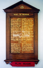
Photograph, Roll of Honour Board, Eltham War Memorial, 2005
This 1954 Roll of Honour board was an action of the WW2 Eltham War memorial Trust, for hanging in their Child Welfare Centre building on their property in Main Road, Eltham. The Johnstons Furniture Production Company made up the board and had the names of the local Eltham enlistees applied in gold lettering at a total cost of £13.10.00. The names were copied by the Eltham RSL from the obelisk which was first erected by the WW1 Eltham Peace Celebrations in August 1919 at the northwest corner of Bridge Street and Main Road. During road widening plans by the Council, the obelisk was moved to the garden area of the refurbished RSL branch building in Main Road for safekeeping. The Honour Roll Board was sent to the Eltham RSL sub-branch around 1999. Following the merger of the Eltham and Montmorency sub-branches and sale of the Eltham property, the obelisk was relocated to a location in front of the Eltham War Memorial. The Honour Roll Board was retrieved by former Eltham District Historical Society President, Harry Gilham in September 2004 who arranged for it to be hung in the Eltham War Memorial Hall (former Children's Library). It is attached to the brick wall face of the west (rear) wall of the Hall.Colour photo print and 18 photocopied and hand written mixed media pages1953, briar hill timber, cr. e.j. andrew, eltham rsl sub-branch, eltham war memorial, eltham war memorial hall, eltham war memorial trust, ernie andrew, harry gilham collection, honour roll, johnstons furniture production company, johnstons furniture productions, meeting minutes, minute book, montmorency-eltham rsl sub-branch, nillumbik shire council, roll of honour, stanley s addison collection, stanley simpson addison -
 Eltham District Historical Society Inc
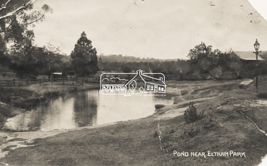
Photograph - Photo Postcard, Pond near Eltham Park, c.1910
This card depicts the pond near Eltham Park (later Eltham Lower Park) circa 1910. The view is taken from Maria Street (Main Road) opposite Dalton Street looking northwest across the Dalton Street road extension reserve (now Wingrove Park Trail) and Jarrold farm. A haystack is visible. Also visible is a gas streetlight and White Cloud cottage which belonged to the Jarrold family From the same collection as accession no. 00778, (Yarra at Eltham) - sent from Eltham and addressed to "Mr J. L. Brown, "Elthamville", Tinning Street, Brunswick" "with love from Nellie" who was most probably a member of the extended Brown family, and no. 00780 (Eltham, J.H. Clark Photo - dated 20 May 1911). Sending postcards to family and friends including short messages was a common form of communication in the early 20th century. Part of a slide show presentation "Bridges & Waterways of the Shire" by Russell Yeoman to the 13 September 1989 Society meeting. The presentation included slides of historic photos from the Shire of Eltham Pioneers collections as well as several recent views.Sending postcards to family and friends including short messages was a common form of communication in the early 20th century.Sepia postcard in very poor condition which has been removed from an album. Glue residue and album page adhering preventing information being readFront: Pond near Eltham Parkpostcard, eltham, pond, dalton street, duck pond, eltham park, elthamville, gas lamp, haystack, jarrold cottage, jarrold property, main road, maria street, white cloud cottage, wingrove park trail