Showing 2561 items matching " act"
-
 Kyneton RSL Sub Branch
artefact, VC Medal
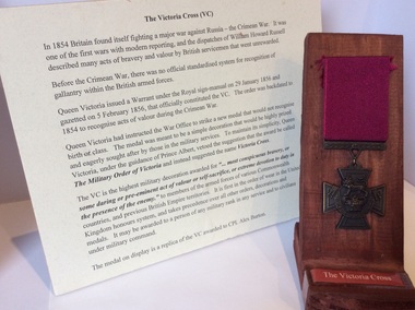
The Victoria Cross is the highest military decoration awarded for “... most conspicuous bravery, or some daring or pre -eminent act of valour or self sacrifice, or extreme devotion to duty in the presence of the enemy” to members of the armed forces of Commonwealth countries. This item is part of a collection of items relating to Cpl Alexander Burton.VC No 384Two items Medal on wooden display stand, Medal hangs on red ribbon with the words: The Victoria Cross; on label at base. Information board gives details of the history of the Victoria Cross. The medal is a replica.Front: For Valour Back: COPYvc -
 Federation University Historical Collection
Correspondence, Trower. Still & Keeling, Legal correspondence concerning the death of Frank Wright, 1970/71
Frank Wright was a renown resident of Smeaton, where he was born on 2 August 1901. He lived at Laura Villa, and attended Smeaton State School. His father William was a gold miner and his mother's name was Sarah. Their family won many singing and instrumental awards. Frank was tutored by Percy Code and was awarded a gold medal for the highest marks in the ALCM examinations in the British Colonies at the age of seventeen years. He became the Australian Open Cornet Champion by the age of eighteen. A year later, Frank conducted the City of Ballarat Band, and later the Ballarat Soldiers’ Memorial Band. He formed the Frank Wright Frisco Band and Frank Wright and his Coliseum Orchestra. These bands won many South Street awards, and Frank as conductor won many awards in the Australian Band Championship contest. In 1933 Frank Wright sailed to England to conduct the famous St Hilda’s Band and was later appointed Musical Director of the London County Council, where he organized many amazing concerts in parks, in and around the London district. He was made Professor of Brass and Military Band Scoring and conducted at the Guildhall of Music and Drama. Frank was often invited to adjudicate Brass Band Championships around Europe, in Australia, including South Street and in New Zealand. The Frank Wright Medal at the Royal South Street competition is awarded to an individual recognized as making an outstanding contribution to brass music in Australia.Four pieces of legal correspondence concerning the death of Frank Wright plus an inventory of furniture and musical instruments from chartered surveyors addressed to John Hosier. Also included is a telegram from Frank's sister Laura Ritchie, authorising Mr John Hosier to act for the family. The legal correspondence is from Trower, Still & Keeling and the inventory is from E. Copping Joyce & Son.2). Several notes written - one in blue pen, one in black pen and another in pencil. 1a)., 1b)., 2)., 3). & 4). all have handwritten signaturesfrank wright, john hosier, laura ritchie, trower still and keeling -
 Bendigo Historical Society Inc.
Document - CONNELLY TATCHELL & DUNLOP COLLECTION: ENVELOPES & POSTCARD:
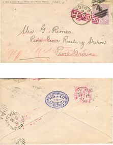
Envelopes & postcard from Connelly Tatchell & Dunlop (Tatchell, Dunlop, Smalley & Balmer): a unclaimed envelope to Mr G Rimes, Pine Grove Railway Station Pine Grove, 1893; b. Unclaimed envelope to Mary Bell, Yalambe, (with enclosed letter re mortgage payment due); c. Postcard re receipt of Return under Land Tax Assessment Act; 1913.business, legal, connelly tatchell & dunlop -
 Bendigo Historical Society Inc.
Document - HOSPITAL BENEFITS ASSOCIATION (VARIOUS PAPERS/FORMS), 1938
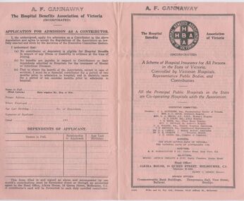
Hospital Benefits Association (Various Papers/Forms) a.: Description of HBA and Application Form for admission as a Contributor; B. as for a.; c. 'National Health and Pensions Insurance Act 1938' - facts for linking up with HBA; d. Form of Application for membrship of the Society; e.: Circular: Bendigo & District Contributory Fund (Medical Benefits). A. Inscriptions (rubber stamp) - 'A. F. Gannaway'; e.: 'in handwriting '20.8.35'organization, club/society, health -
 Bendigo Historical Society Inc.
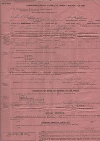
Document - ERROL BOVAIRD COLLECTION: WHEAT BOUNTY CLAIM
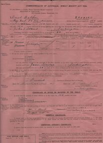
The John Bovaird Collection : Commonwealth of Australia Wheat Bounty Act 1934 State of Victoria Claim for Payment. By Errol Balfour Bovaird of May Reef PO via Avonmore. Regarding 150 bushels delivered for sale to John T Stewart of Lockington. Wheat produced on 50 acres : Allotment 25 Parish of Pannoo Bamawm. Dated 13/4/1935. Pink paper.agriculture, farm, wheat crop -
 Bendigo Historical Society Inc.
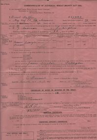
Document - ERROL BOVAIRD COLLECTION: WHEAT BOUNTY CLAIM
The John Bovaird Collection. Commonwealth of Australia Wheat Bounty Act 1934 State of Victoria Claim for Payment. By Errol Balfour Bovaird of May Reef PO via Avonmore. Regarding 96 bushels delivered for sale to R. Anderson of Lockington. Wheat produced on 50 acres : Allotment 25 Parish of Pannoo Bamawm. Dated 13/4/1935. Pink paper.agriculture, farm, wheat crop -
 Bendigo Historical Society Inc.
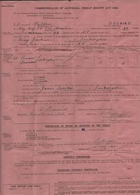
Document - ERROL BOVAIRD COLLECTION: WHEAT BOUNTY CLAIM
The John Bovaird Collection. Commonwealth of Australia Wheat Bounty Act 1934 State of Victoria Claim for Payment. By Errol Balfour Bovaird of May Reef PO via Avonmore. Regarding 96 bushels delivered for sale to R. G. Anderson of Lockington. Wheat produced on 50 acres : Allotment 25 Parish of Pannoo Bamawm. Dated 13/4/1935. Pink paper.agriculture, farm, wheat crop -
 Bendigo Historical Society Inc.
Document - ERROL BOVAIRD COLLECTION: WHEAT BOUNTY CLAIM
The John Bovaird Collection. Commonwealth of Australia Wheat Bounty Act 1934 State of Victoria Claim for Payment. By Errol Balfour Bovaird of May Reef PO via Avonmore. Regarding 96 bushels delivered for sale to Henry Jackson of Lockington. Wheat produced on 50 acres : Allotment 25 Parish of Pannoo Bamawm. Dated 13/4/1935. Pink paper.agriculture, farm, wheat crop -
Clunes Museum
Document - MEMORANDUM
.1 MEMORANDUM OF TRANSFER NO. 3115 BETWEEN JOHN HOLDEN, GLENDARUEL AND DAVID MCDONALD, TOURELLO. ALLOT. 43 SECTION B, SMEATON. DATED 7 SEPT. 1894 .2 APPENDIX 1 (RULE 24) PART II OF THE MINES ACT 1890 MINING LEASE ON PROPERTY SITUATED TOURELLO. OWNED BY LACHLAN MCLENNAN APPLICANT FOR MINING LEASE FREDERIC GODFREY HUGHESfrederic godfrey hughes, john holden, donald mcdonald -
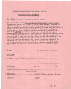 Ballarat Tramway Museum
Document - Form/s, Ballarat Tramway Preservation Society (BTPS), "Ballarat Tramway Preservation Society - Volunteers Worker's Indemnity", 1974
Stencil typed, Duplicated form on pink quarto size paper to act as BTPS Limited Volunteer Workers Indemnity. Has space for office use of the form. Was for use by people over 21 years of age. See also Reg. Item 1516 and 933.1 for other issues of this form. Has printing information "2-500-1974" on bottom of form, assume that printed in 1974.trams, tramways, btps, volunteers, indemnity -
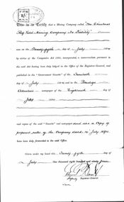 Bendigo Historical Society Inc.
Document - CHRISTMAS REEF GOLD MINING CO. COLLECTION: LETTER OF INCORPORATION
Document certifying that the Christmas Reef Gold Mining Company No Liability was on the 25th day of July 1894, by virtue of the companies Act 1890, incorporated. Copies of notice in Gazette. Signed Deputy Registrar General Edward Daniel ? Also, handwritten note Principal nuggets (sic ) found on Bendigo G. Mackay's History of Bendigo - lists nuggets found in the early 1850's.bendigo, mining, christmas reef gold mining -
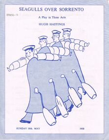 Bendigo Historical Society Inc.
Document - VIKKI SPICER COLLECTION: BENDIGO OPERATIC SOCIETY PROGRAMME BOOKLET, Sunday 18th May, 1958
Blue & White Paper Document Theatre Production Seagulls Over Sorrento Hugh Hastings Three Act Play. Bendigo Training Prison Performance Sunday 18th May 1958. Produced & Directed By Keith G. Cast: Rex S., Norman B., Des Nicholas, Keith G., Graham M., Robert K., Andrew F., Ronald A. Allan Q.clubs and associations, theatre, bendigo training prison, https://en.wikipedia.org/wiki/seagulls_over_sorrento -
 Bendigo Historical Society Inc.
Document - Bendigo Chamber of Commerce Minutes Book Volume 1, 1896-1904
The Bendigo Chamber of Commerce and Industry was constituted in 1886 with the vision to be the single voice for the business community across greater Bendigo. ‘Be.Bendigo’ is the trading name of the organisation ‘Bendigo Business Council’ which was formed in 2008 as a merger between two Bendigo business organisations: The Bendigo Chamber of Commerce and Central Victorian Business Network (CVBN). Upon the merger, Bendigo Business Council continued the functions of both the Chamber and CVBN by providing advocacy, networking and events to members and partners.Large minute book/journal - 366 pages of hand-written minutes of meetings of the Bendigo, Eaglehawk and District Chamber of Commerce and Industries. First entry 15 December 1986. Last entry 11 November 1904. Includes newspaper cuttings pasted onto pages and a letter from Barkly Hyett agreeing to act as solicitor for members of the Chamber. (dated 11 August 1891).Secretary's Copyhistory, bendigo, bendigo chamber of commerce collection -
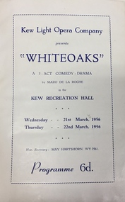 Kew Historical Society Inc
Programme, Kew Light Opera Company, Whiteoaks, 1956
The Kew Light Opera Company was formed in 1952, and mounted a number of musical and variety productions each year until it was subsumed in the "Q" Theatre Guild in 1957. Most of the Company's performances took place in the Kew Recreation Hall in Wellington Street, Kew. A list of its productions by year includes: 1952 Florodora 1953 The Cingalee 1953 San Toy OR The Emperor’s Own 1953 Celebratory variety performance 195? While the Sun Shines 1954 A Country Girl 1954 Our Miss Gibbs 1955 The Toreador 1955 The Arcadians 1956 The Maid of the Mountains 1956 Whiteoaks 1956 Good night Vienna! 1957 A Country GirlThe Marion Tilley scrapbook is a significant record of performing arts in Melbourne during the 1950s and 1960s. The scrapbook includes programmes, photographs, newspaper reports and personal annotations which are a rich source of detail about repertoire, performers, and artistic sensibility in the period.Souvenir programme isued by the Kew Light Opera Company for a performance of 'Whiteoaks: a 3-Act Comedy-Drama' by Mazo de la Roche. Performances were held in the Kew Recreation Hall on 21 and 22 March 1956. The programme forms part of a scrapbook that includes programmes, photographs and theatre reviews for the Kew Light Opera Company and later "Q" Theatre Guild.theatre (kew), kew light opera company, kew recreation hall, performing arts -
 Royal District Nursing Service (now known as Bolton Clarke)
Document, black and white, c.1957
This document tells of the separation of Melbourne District Nursing Society and After Care Hospital.The Melbourne District Nursing Society was founded in February 1885. It built the After-Care Home in 1926, and the Society became the 'Melbourne District Nursing Society and After-Care Home' until 1935 when the word 'Home' was replaced by the word 'Hospital'. In 1957 the two bodies separated, with one becoming the 'Melbourne District Nursing Service', and the other the 'After-Care Hospital'. This document from the Lieutenant-Governor of Victoria shows the 'Closure of the Melbourne District Nursing Society and After Care Hospital' which took affect with dissolution on the 1st of September 1958.Black and white document: 'Closure of the Melbourne District Nursing Society and After Care Hospital' The document is bold black printing on a white background. It commences 'Hospital and Charities Act 1948 (No. 5300); follows are the names of those present being the Lieutenant Governor of Victoria and four other men. The body of the document contains twenty-four lines and finishes with ‘A. Mahlstedt Clerk of the Executive Council’.melbourne district nursing society, after-care home, after- care hospital, melbourne district nursing service, mdns, rdns, royal district nursing service -
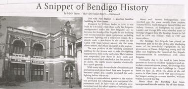 Bendigo Historical Society Inc.
Newspaper - JENNY FOLEY COLLECTION: A SNIPPET OF BENDIGO HISTORY
BHS CollectionBendigo Weekly date unknown. '' A snippet of Bendigo history'' by Edith Lunn, The View Street story, continued. In this article Edith Lunn describes the story of the Old Fire Station. Designed by William Beebe in 1890 and built by J. R. Daley when three early fire brigades amalgamated under the '' fire Brigades Act'' to become the Bendigo Fire Brigade. The clip is in a foldernewspaper, bendigo, bendigo weekly -
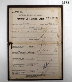 Bendigo Military Museum
Administrative record - CARD, RECORD OF SERVICE, Australian Navy - Form A170, C. 1957 - 60
Service Card, brown buckram colour, with fold line.“Army Form AAF A170 National Service Act 1951-53 Record of Service Card Number 188796 Registration No V70118 Name: O'Mahoney, Brian Kevin Dates: 8 Jan 1957 to 30 Jun 1960” Signed by: ADJT 38 Inf Bnservice, national service -
Thompson's Foundry Band Inc. (Castlemaine)
Work on paper - Sheet Music, Shipley Douglas et al, The Arcadians
20 parts for Brass band. This piece is a selection of pieces from the 1909 Edwardian style musical comedy - the Arcadians. Selected and arranged by Shipley Douglas includes: Opening Chorus, Chorus of Waitresses, Back your fancy, The girl with a brogue, the joy of life, my Motter, Bring ma a rose, Charming Weather, Fickle Fortune and Arcady is every young.20 parts for Brass band. This piece is a selection of pieces from the 1909 Edwardian style musical comedy - the Arcadians. Selected and arranged by Shipley Douglas includes: Opening Chorus, Chorus of Waitresses, Back your fancy, The girl with a brogue, the joy of life, my Motter, Bring ma a rose, Charming Weather, Fickle Fortune and Arcady is every young. Parts: E♭ soprano cornet Solo cornet in B♭ Repiano cornet in B♭ 2nd cornet in B♭ 3rd cornet in B♭ Flugel horn in B♭ 1st horn in E♭ 2nd horn in E♭ 3rd horn in E♭ 4th horn in E♭ 1st baritone in B♭ 2nd baritone in B♭ 1st euphonium 2nd euphonium 1st tenor trombone 2nd tenor trombone Bass trombone B♭ bass (2 copies) E♭ bass (2 copies) Drums.fiction20 parts for Brass band. This piece is a selection of pieces from the 1909 Edwardian style musical comedy - the Arcadians. Selected and arranged by Shipley Douglas includes: Opening Chorus, Chorus of Waitresses, Back your fancy, The girl with a brogue, the joy of life, my Motter, Bring ma a rose, Charming Weather, Fickle Fortune and Arcady is every young. edwardian musical, musical, shipley douglas, lionel monkton, howard talbot, chorus of waitresses, back your fancy, the girl with a brogue, the joy of life, my motter, bring me a rose, charming weather, fickle fortune, arcady is ever young, chappel & co, chappell's bras and reed journal -
 Wannon Water
Medallion, Hamilton Waterboard Medallion
Chairman's insignia designed by Russell Worland. Russell Worland was the secretary of the Hamilton Water Authority and Hamilton Sewerage Authority and became the secretary of the Hamilton Water Board. Kevin Safe was an engineer and later became CEO of Glenelg Water. Hamilton Water Board was constituted in October 1 1983 under the Water and Sewerage Act 1983 and amalgamated Hamilton Waterworks Trust and Hamilton Sewerage Authority. The Board was abolished on July 1 1994 under the Water Act 1989 when it amalgamated with Glenelg-Wannon Water Board, Shire of Glenelg Waterworks Trust and Shire of Mount Rouse Waterworks Trust to form Glenelg Region Water AuthorityMedallion with Insignia worn at official functions.Round silver medallion - with raised symbol of the cornucopia with water coming out of it. The obverse is a representation of pipes. The medallion is attached to light blue and silver striped white taffeta backing ribbon slightly dented "Presented: R Worland KS Safe/ Rocca" ( around rim) "Hamiton /Water /Board" ( Back)water authority, hamilton -
![Photograph, Blue House production [WaHIGH], 1967c](/media/collectors/4f729f5697f83e03086015b8/items/6534c79963316f603fdfeba1/item-media/6534c80c63316f603fdfee26/item-fit-380x285.jpg) Greensborough Historical Society
Greensborough Historical SocietyPhotograph, Blue House production [WaHIGH], 1967c
Watsonia High School students rehearse for the annual one act play competition c1967. This is Blue House's melodrama in which the villain is about to evict the widow and her child. Doug Jacquier on left, possibly Wendy Simpson and unknown male.Part of the Watsonia High collection of Glynne Pietzsch who was a student at Watsonia High in the 1960s.3 black and white photographswatssonia high school, school plays -
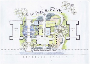 Queen Victoria Women's Centre
Artist Impression, New Public Park, February 1994
This was an artist (unknown) impression of the proposed ground floor and surrounding area of the QVWC. This did not eventuate due to heritage and funding restrictions. Probably commissioned by QVWC Inc. - created before the act came into effect and the first Trust appointed or meeting occurred. A3 copy of an impression of what the QVWC site was to be.heritage site, architectural plan, women's centre -
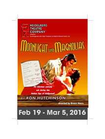 Heidelberg Theatre Company Inc..
Program Photos Reviews Newsletter Poster Articles, Moonlight and Magnolias by Ron Hutchinson directed by Bruce Akers
Produced and acted by members of the Heidelberg Theatre Company and all supporting areas including set design, set building, lighting and sound design and operation, costumes, front of house, ticket sales, publicity and administration were undertaken by HTC members.Artistic aesthetic social significance for the members, subscribers and audience of the heidelberg theatre companyAll items in good condition 1 Program 2 photos 3 Review 4 Newsletter 5 poster 6 newspaper article and photo from The Melbourne Observer heidelberg theatre company, htc, 2016, 411 -
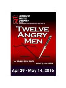 Heidelberg Theatre Company Inc..
Program Photos Reviews Newsletter Poster Articles, Twelve Angry Men by Reginald Rose directed by Chris Baldock
Produced and acted by members of the Heidelberg Theatre Company and all supporting areas including set design, set building, lighting and sound design and operation, costumes, front of house, ticket sales, publicity and administration were undertaken by HTC members.Artistic aesthetic social significance for the members, subscribers and audience of the heidelberg theatre companyAll items in good condition 1 Program 2 photos 3 review 4 Newsletter 5 poster 6 newspaper The Heidelberger.letter to the editor from HTC patronheidelberg theatre company., htc, twelve angry men by reginald rose, director chris baldock, 2016, 413 -
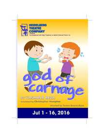 Heidelberg Theatre Company Inc..
Program Photos Newsletter Poster Article, God of Carnage by Yasmina Reza directed by Therese Maurici-Ryan
Produced and acted by members of the Heidelberg Theatre Company and all supporting areas including set design, set building, lighting and sound design and operation, costumes, front of house, ticket sales, publicity and administration were undertaken by HTC members.All items in good condition heidelberg theatre company, htc, god of carnage by yasmina reza, director terese maurici-ryan, 2016, 413 -
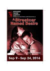 Heidelberg Theatre Company Inc..
Program Photos Review Newsletter Poster, A Streetcar Named Desire by Tennessee Williams directed by Karen Wakeham
Produced and acted by members of the Heidelberg Theatre Company and all supporting areas including set design, set building, lighting and sound design and operation, costumes, front of house, ticket sales, publicity and administration were undertaken by HTC members.All items in good condition heidelberg theatre company., htc, a streetcar named desire by tennessee williams, 2016, 414, karen wakeham -
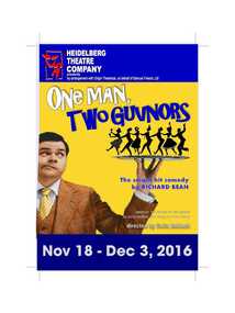 Heidelberg Theatre Company Inc..
Program Photos Reviews Newsletter Poster Articles, One Man, Two Guvnors by Richard Bean directed by Chris Baldock
Produced and acted by members of the Heidelberg Theatre Company and all supporting areas including set design, set building, lighting and sound design and operation, costumes, front of house, ticket sales, publicity and administration were undertaken by HTC members.All items in good conditionheidelberg theatre company, htc, one man, two guvnors by richard bean, 2016, 415, chris baldock -
Federation University Historical Collection
Sheet Music, mid 1900s
Frank Wright was a renown resident of Smeaton, where he was born in 1901. He lived at Laura Villa, and attended Smeaton State School. His father William was a gold miner and his mother's name was Sarah. Their family won many singing and instrumental awards. Frank was tutored by Percy Code and was awarded a gold medal for the highest marks in the ALCM examinations in the British Colonies at the age of seventeen years. He became the Australian Open Cornet Champion by the age of eighteen. A year later, Frank conducted the City of Ballarat Band, and later the Ballarat Soldiers’ Memorial Band. He formed the Frank Wright Frisco Band and Frank Wright and his Coliseum Orchestra. These bands won many South Street awards, and Frank as conductor won many awards in the Australian Band Championship contest. In 1933 Frank Wright sailed to England to conduct the famous St Hilda’s Band and was later appointed Musical Director of the London County Council, where he organized many amazing concerts in parks, in and around the London district. He was made Professor of Brass and Military Band Scoring and conducted at the Guildhall of Music and Drama. Frank was often invited to adjudicate Brass Band Championships around Europe, in Australia, including South Street and in New Zealand. The Frank Wright Medal at the Royal South Street competition is awarded to an individual recognized as making an outstanding contribution to brass music in Australia.All handwritten scores of music by Frank Wright by other composers- 1). Handwritten in pencil - 'Pastourelle' by Francis Poulence for trumpet in B flat 2). Handwritten in black pen, 7 pages - 'Minuet' by Paderewski 3). Handwritten in black pen - 'Sonatine' by Schubert 4). Handwritten in blue pen with red accents, 8 pages - 'Prelude to Act 1 "Traivata"' by Verdi and arrangement by Drake Rumn?All handwrittenfrank wright, pastourelle, frances poulence, sonatine, schubert, minuet, paderewski, traivata, verdi, sheet music -
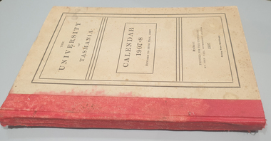 Federation University Historical Collection
Book, John Vail, Government Printer, University of Tasmania Calendar, 1907-1908, 1907
Brown hardcovered book with read tape spine. The book includes: Tasmanian University Actm 1890, High School Vesting Act, Statutes, Regulations, Rules, Public Examinations, Local Examinations in Music, Association with the University of Oxford, University Council, Graduates, Matriculated Students, Records and Close Lists, Annual Report for 1906, Benefaction and Donations, Rhodes SCholarship, Bequests, Women's University Union university of tasmania, tasmania, education, women's university union, oxford university -
 Bendigo Historical Society Inc.
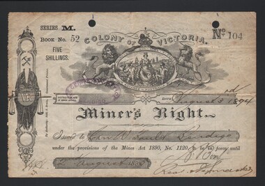
Document - MINER'S RIGHT, 1894
Document. Miner's Right. Miner's Right issued to John W Faul of Bendigo dated 3 August 1894, under provisions of the Mines Act 1890. No 104 of Book 52, Series M. Cost 5 shillings. 1 year licence. Printed - Robt. S Brain, Government Printer. Pale colour with black ink, and purple stamp. Signature unreadable. B. B?cottage, miners, miner's right, john w faul, robt. s brain government printer. -
Clunes Museum
Document - LAND LICENCE
.1 LICENCES FOR DEPARTMENT OF LANDS AND SURVEY - OCCUPATION BRANCH. LICENCE NO 315892 TO 315901. 25 FEBRUARY 1901 TO FEBRUARY 1902 STAPLED TOGETHER .2 LAND ACT 1869 SEC 20 BOOK 88. ON SPINE "THE CROWN - LAND ACT1869. SEC 20. 88 RECEIPTS FROM REVENUE OFFICE NO 2 TO 118 RECEIPTS 119 TO 249 HAVE NOT BEEN USED, THEY ARE CUT IN HALF.2 WHITE ROUND STICKER WITH "5" ON FRONTdepartment of lands and survey, land act 1869, occupation branch, revenue office