Showing 1442 items matching " lithographers"
-
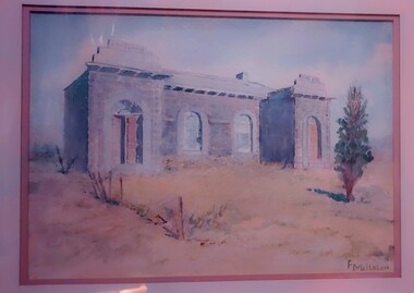
 Mont De Lancey
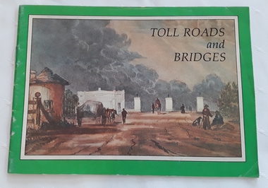
Booklet, Department of Main Roads, Toll Roads and Bridges, 1981
A brief history of tolls used throughout history, dating back around 1950 B.C. Early English and USA use is mentioned. Road and bridge tolls in Australia were collected for construction and maintenance of particular roads and bridges similar to their use in England. The clear photographs show the development in the this country up to 1981 when the brochure was published.A small slim rectangular paperback brochure with a lithograph of the "New Toll Gate" on Parramatta Road, published in J.G. Austin's Sydney Views. Green and white edging surrounds the picture with the title Toll Roads and Bridges printed in black lettering at the top right of the cover. On the back is a photograph of Toll cabins at the northern end of the Sydney Harbour Bridge showing automatic and manual toll booths with the symbol for NAASRA and National Association of Australian State Road Authorities printed in black and white at the bottom. Pp. 20. There are many photographs inside.non-fictionA brief history of tolls used throughout history, dating back around 1950 B.C. Early English and USA use is mentioned. Road and bridge tolls in Australia were collected for construction and maintenance of particular roads and bridges similar to their use in England. The clear photographs show the development in the this country up to 1981 when the brochure was published.road tolls, roads, bridges, history of tolls -
 Bendigo Historical Society Inc.
Document - MARKS COLLECTION: PLAN OF SANDHURST CITY CENTRE AND SURROUNDING AREA ( NO. 1 )
Plan on heavy parchment - section neatly cut out of area now Kennington. Written on plan in black print ' Sheet No. 1. Sandhurst'. Plan shows Government Camp, Commissioner's Gully, old cemetery site, manure depot, cattle market, Benevolent Asylum Reserve, railway reserve. Landowners' names on allotments. On bottom lithographed at the Department of Lands and Survey, Melbourne, by D. Henerson, March 12th., 1867 Plan part of George Lansell, Fortuna auction, documents found in wardrobe purchased by Marks family in 1930's.bendigo, planning, sandhurst 1867 -
 Bendigo Historical Society Inc.
Document - MARKS COLLECTION: PARISH PLAN OF WHITE HILLS
Sepia coloured map showing allotments in Parish of Sandhurst (White Hills) Written on LH side of map town and Suburban Lots White Hills Parish of Sandhurst. Scale is shown in chains. Surveyed by Horage Walker. Photo lithographed at the Department of Lands & Survey, Melbourne by J.Noone, Price 1/-. 6th. January 1865. Map shows Race Course Reserve at top of sheet, Municipal boundary is marked on LH side. Comments re vegetation throughout map. For example, poor soil timbered with Box scrub.on the back--Plan of Land White Hills Sandhurstbendigo, planning, white hills parish map, horage walker, j noone, department of lands and survey, -
 Bacchus Marsh & District Historical Society
Map, Plan of the property of Messers Atkins and Clarke to be sold at the Mansion, Bacchus Marsh 19th April 1856. Copy 1
This plan of land allotments for sale indicates the property once owned by the Bacchus family in and around the township area of Bacchus Marsh. The Bacchus family sold their property in Bacchus Marsh to John Atkins and Robert Nalder Clarke in March 1851. Atkins and Clarke kept the property for a number of years until April 1856 when these allotments were put up for sale.This plan is almost identical to another copy held by the Bacchus Marsh and District Historical Society, VC Record 452, BMDHS collection). This plan, VC Record 707 Copy 1, contains a little more detail overall than VC Record 452 Copy 2, such as who did the survey work for the plan (R.C. Bagot) and who the selling agents were, (W.M. Tennent), and on the right side of the plan near the Lerderderg River is indicated the general area for a second parcel of land from this sale which is to be sold. There is also a compass illustration indicating north and south compass points.This is a very early land sales plan for the township of Bacchus Marsh and it therefore provides some clues as to how the early urban development of the township took place. Upon seeing the map in 1911 Bacchus Marsh Express newspaper editor Christopher Crisp wrote "The sale appears to have created the present township, which had a nucleus in earlier times further east", Express, 30 September, 1911, page 3.A single page paper plan showing allotments of land for sale. The subdivided land shown was owned by John Atkins and Robert Nalder Clarke, but previously owned by the Bacchus Family and was in and around their Manor House (Mansion) property in Bacchus Marsh.There are 5 portions of land further divided into numerous small portions. The land for sale is bounded by the present day streets of Main Street, Young Street, McFarland Street, Morton Streets, Crook Street, and part of the eastern section extends to the Lerderderg River. Scale: 8 chains to 1 inch The plan is pasted into a bound volume containing 76 maps or plans in total. BMDHS Loc: AR/B12/S4 Bacchus Marsh Township and Nearby Districts Maps Volume In-house Digital copies: BMDHS, Computer Network: Maps\Bacchus Marsh Township and Nearby Districts Maps VolumeHeading: Plan of the first portion of land. The property of Messers Atkins and Clarke situate at Bacchus Marsh. To be sold by W.M. Tennent & Co. at the Mansion on the Ground on Saturday the 19th April 1856. Below heading: Jas Ferguson, Lithographer On upper right side: Subdivided by R.C. Bagot London and Liverpool Chambers, Melbourne. 'Thos Taubman'. Post Office Stamp: BACCHUS MARSH VICTORIA MY 6, 63bacchus marsh victoria maps, bacchus family, land sales, manor house bacchus marsh -
 Warrnambool and District Historical Society Inc.
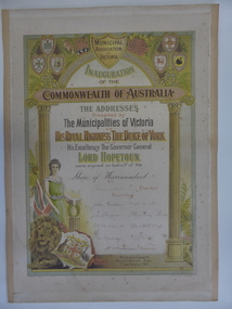
Certificate, 1901 Commonwealth of Australia Municipal Association, 1901
This is a Federation certificate showing the signatures of the Shire of Warrnambool personnel who signed the addresses presented by the Municipalities of Victoria to the Duke of York and the Governor-General in 1901 on the occasion of the Federation of the six colonies in Australia. This was a highly significant event in Australia’s history and Warrnambool shared in this occasion by voting overwhelmingly in the Referendum in favour of Federation. This certificate shows the official local government acceptance of the inauguration of the Commonwealth of Australia and the regard for matters of Empire and the representatives of British Royalty. It also has the signatures of the Shire personnel, many of whom were prominent men in the Warrnambool district in the early 20th century, especially Gideon Nicol, James Lindsay, Alexander Rollo and John Glasgow. It was reported in the Warrnambool Standard at the time that this certificate had been designed and illuminated by Victor Henry, an art student from Warrnambool and the son of one of Warrnambool’s Councillors, This is a certificate indicating that the Shire of Warrnambool Councillors signed the Addresses presented by the Municipalities of Victoria to the Duke of York and the Governor- General in January 1901. The certificate is mounted on card with paper binding on the edges and contains the signatures of the President of the Shire of Warrnambool, nine Councillors and the Shire Secretary. It is highly ornamented with lithographs of the crests of the six States of Australia, an archway , an image of a woman representing the British Empire, a lion, a British flag and the crest of ‘United Australia’ and other symbols. The printers of this copy were Sands and McDougalls of Melbourne. The certificate is coloured in mostly yellow, green and brown tonings. The signatures are in black ink. federation, shire of warrnambool federation certificate, warrnambool -
 Bendigo Historical Society Inc.
Photograph - HARRIS COLLECTION: MALE PHOTO, Nineteenth Century
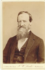
Black & White studio portrait photograph. Bearded moustached male aged approx mid fifty. Head & Shoulders. Jacket & Vest. Printed on front. 7 Collins St East, J W Lindts Melbourne. Extensive Reverse Printing include. From J W Lindt's Studio above lithograph view of Melbourne. Special Publications. 'Album of Australian Aboriginals', Characteristic Australian Forest Scenery, Genre, Pictures of Bush Characters, Men of Mark and distinguished Visitors to Victoria. Gold, Silver & Bronze Medals and Diplomas. Awarded at Philadelphia, Paris, Sydney, Brisbane, Sandhurst.J W Lindt's Studiophotograph, person, male -
 Bendigo Historical Society Inc.
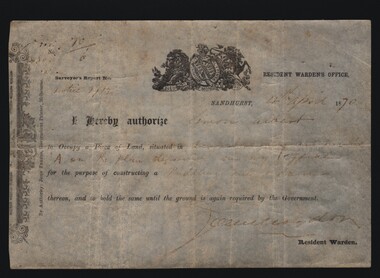
Document - MINERS RIGHT/LAND LEASE, 1870
Document. Miners Right/Land Lease. Paper document dated 4th April 1870 authorizing Simon Albert to construct a puddling mill and dam on land in Devonshire Gully. It reads: I hereby authorize Simon Albert to occupy a piece of land, situated in Devonshire Gully and marked 'A' on the plan deposited in my office for the purpose of constructing a puddling mill and dam, thereon, and to hold the same until the ground is again required by the Government. Printed by John Ferres, Government Printer, Melbourne. Signed by Resident Warden (Signature Unreadable). Lithograph drawings - one of a lion and unicorn with Latin writing.cottage, miners, miners right/land lease, simon albert, devonshire gully, john ferres governmant printer -
 Flagstaff Hill Maritime Museum and Village
Map - Survey Map, F.F. McGovern, Yangery - County of Villiers, 1884
A surveyor was employed to measure the land designated as Yangery, County of Villiers, in the Borough of Warrnambool. The area on the map is similar to the earlier Farnham Survey undertaken by William Rutledge in the 1850's. Warrnambool was a Borough between 1863-1883. Coutours, waterways, sea and other significant points are shown. The distances are accurately measured. This survey map was used for planning future land sales, recreation areas and roads. WILLIAM RUTLEDGE (1806-1876) William Rutledge surveyed the land known as Farnham in southwest Victoria in 1843. His tenants made him a profitable business from working the land there. In 1863 Rutledge moved from nearby Port Fairy to Farnham and became very successful in breeding sheep, which he imported from J.R. Kirkham of Lincolnshire, England. He also bred horses on his land. The survey map of Yangery is important for its connection with renowned surveyor William Rutledge. The map shows the growth of landholders in the district when compared to the original Rutledge survey of the 1850's.Survey map of Yangery, titled "Yangery - County of Villiers". Printed on white paper, mounted on brown paper. c. 1863-1876. Comments printed on the Map include; Special Survey by William Rutledge, Photo-lithographed at the Department of Lands and Survey, Melbourne by W.J. Burson, Price 1/- [one shilling]. Scale is in Chains. Map has boundaries of Koroit Borough, Meerai, Purnim, Wangoom, Borough of Warrnambool, Mentions the Proposal of Tower HIll for Public Recreation. The map names the owners of the land at that time. Hand written pencil marks and figures and "Sauls fence" drawn on map. Hand written pencil markes and figures and "Sauls fence" drawn onto map. "For Department Use only". "Scale: 8 chains to 1 inch" flagstaff hill, warrnambool, shipwrecked-coast, flagstaff-hill, flagstaff-hill-maritime-museum, maritime-museum, shipwreck-coast, flagstaff-hill-maritime-village, county of villiers map, yangery district, w.j. burson, borough of warrnambool, koroit, purnim, meerai, wangoom, proposal of tower hill for public recreation, special survey by william rutledge, william rutledge, farnham, lincolnshire sheep, clydesdale -
 Bendigo Historical Society Inc.
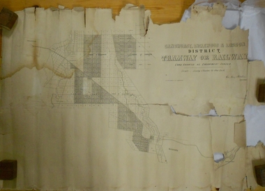
Map - MARKS COLLECTION: TRAMWAY OR RAILWAY MAP SANDHURST
Original map of 'land granted as endowment' for tramway or railway. On top Rh corner of map, in bold print 'Sandhurst, Inglewood & Loddon district Tramway or Railway. Land granted as endowment shaded, scale 60 chains to 1 inch. Lithographed by J & W. Holmes, Lith. Sandhurst'. Signed by Geo Avery Fletcher, Engineer. Map shows Parish of Leichardt, Parish of Yarraberb, Parish of Bridgwater and a section of Marong. On bottom RH corner, is small map of Sandhurst, showing railway reserve. Top LH corner, Inglewood. Map shows route of railway line from Sandhurst to Inglewood.map, marks collection, railway, inglewood -
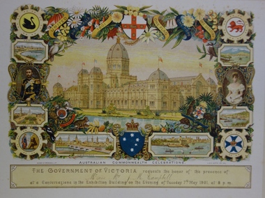
 Kew Historical Society Inc
Document, Sands & McDougall Ltd, Invitation to a ‘Conversazione’ in the Exhibition Building, 1901
A report in the Ballarat Star on 8 May 1901 recorded that: "THE CONVERSAZIONE. A GREAT SUCCESS. The conversazion given by the Government of Victoria at the Exhibition was very largely patronised. the guests includ ing the Prime Minister and a goodly proportion of the distinguished personages now in Melbourne. A programme of high-class music was gone through, and refreshments were served during the evening. Australian wines were very prominent."The document design has artistic and aesthetic merit. While it is not rare, it is representative of the kinds of formal designs used for the Australian Commonwealth celebrations at the time of Federation, and is in excellent condition. Such items as this invitation have local, state and national historic significance as mementoes of a key moment in Australia's history. Locally, the invitation is part of a group of Federation-related items owned and displayed by Mrs Grace Tabulo, the owner of 'Fairyland', 57 Malmsbury Street, Kew.Colour lithograph mounted on card to an evening event, a conversazione, held in the Exhibition Building on the evening of Tuesday 7th May 1901, as part of the Australian Commonwealth Celebrations. The Government of Victoria hosted the event. The invitation shows an etching of the Exhibition Building, surrounded by an ornate border of heraldic shields, portraits of the Duke and Duchess, views of Perth, Adelaide, Melbourne, Sydney, Brisbane and Hobart, and native flora (including wattle, waratah, pink heath, Sturt’s desert pea, and flannel flower), and native fauna (kookaburra, possum, lyre bird, cockatoo and koala). The royal crest ‘Dieu et mon droit’ and the Australian crest, ‘Advance Australia’ are also included.Printed front: UNITED AUSTRALIA 1901 / ONE FLAG / ONE HOPE / ONE DESTINY; AUSTRALIAN COMMONWEALTH CELEBRATIONS / THE GOVERNMENT OF VICTORIA requests the honour of the presence of / [name deleted] / at a Conversazione in the Exhibition Building on the Evening of Tuesday 7th May 1901 at 8 P.M. Reverse [handwritten]: Mrs G. Tabulo, 57 Malmsbury St.sands & mcdougall ltd, documents - invitations, first commonwealth parliament 1901, grace tabulo -- fairyland -- 57 malmsbury street -- kew (vic.) -
 The Beechworth Burke Museum
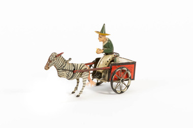
Domestic object - Toy Cart, c1920
The Lehmann toy company exported toys to the USA from 1895 to 1929 and specialized in mechanical, friction transportation and lithographed wind-up tinplate toys. Founded by Ernest Lehmann Co. in Brandenberg, Germany, 1881. In 1951 the fim re-established and is still making friction toys. Some of the most famous include: Autobus, the Dancing Sailor and Icarus. Lehmann distinguished itself early 20th-century by releasing small tin toys which were cheaper than the toys the competition made. End of the 19th century, beginning of th 20th, competitors were producing heavy, cast-iron toys. By the 1920s the Lehmann company had a staff over 800 people and made 80+ different toy designs.How it is significant? (...this item is one of last remaining examples of German toy manufacturing prior to World War One. ) How it is significance to local history? (....this item represents the importance of preserving local history and culture.) German, clockwork, red and white tinplate cart with green and white driver with green pointed hat, being pulled by zebra with red ears and cord tail. 1881/ Lehmann 'Zikra' Marke Pat./USA Appl. / For Jan 1907, Dec 1913 lehmann, toy, beechworth, burke museum, zebra, cart, germany -
 Federation University Art Collection
Printmaking, Les Yachts (Sailing Boats) by Pierre Gazou, 1962
This work was purchased from the exhibition "Original French Lithographs in Colour' held at the Joshua McClelland Print Room in 1963. The foreword noted "The twentieth century revival of lithography had its source in Paris, and in this exhibition, the second held in Melbourne, the catalogue includes some beautiful prints by various younger French artists as well as those by the "old masters" of contemporary lithography, Braque Picasso,, Chagall and Dufy. ... These prints form an interesting section of the regular art auctions in Paris and London, and they are eagerly sought by buyers who want an original work of art by artists whose paintings are far beyond their purses. This item is part of the Federation University Art Collection. The Art Collection features over 1000 works and was listed as a 'Ballarat Treasure' in 2007.art, artwork, garzou, pierre garzou, lithograph, coloured lithograph, colored lithograph, printmaking, edition, available -
 Glenelg Shire Council Cultural Collection
Work on paper - Watercolour, Florence Tatham Mellblom, Portland Shire Hall, n.d
From Antiques Reporter: Florence Tatham Mellblom, (Australian, 1900 - 1983), Visit Portland The First Victorian Settlement, during the Centenary Celebrations from 15th to 23rd November 1934', 1934 colour lithograph, signed 'F. Mellblom' in image lower left, 63.5 x 101.5 cm. Linen-backed. Text continues in lower margin: 'Arbuckle, Waddell Pty Ltd Print, Melb.', Mellblom (nee Henry) was a painter, naturalist and photographer. She was born at Portland, Victoria, and studied art in Ballarat. She was a talented etcher from childhood, and joined the Portland Camera club. She also produced many watercolour paintings of the historic places of Portland. She was married (1932) to Karl Enoch Mellblom.A bluestone building on an arid landscape. Yellow grass in the foreground with one tree standing at the front. There is a blue sky behind. The left hand wing has a door which is slightly open. Above each wing is an engraved piece of stone. Left - Portland, right - Shire. An old rickety fence to the left of the building.Bottom Right - F. Mellblomfemale artist, women, female, landscape, portland landscape, portland shire -
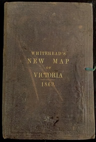 Kew Historical Society Inc
Map, Whitehead's Map of Victoria, With Alphabetical Key, 1869, 1869
When E. Whitehead's New Map of Victoria was released in 1869, an advertisement in the Bendigo Advertiser (16 July 1869) noted that: "This beautifully engraved Map has been revised and brought down to the present time; and, with the Alphabetical Key, is the most complete and the cheapest Map ever published; Price, 6d plain; 1s colored; 2s 6d in case; on linen, post free, 2d extra. E.. WHITEHEAD and CO, Publishers, 67 Collins-street east." The following year, 1870, Whitehead's promoted the edition in the Portland Guardian and Normanby General Advertiser (3 January 1870), advising that: "WHITEHEAD'S NEW MAP OF VICTORIA, 1869 ... is corrected to the latest date, and around is arranged an Alphabetical Key, with Post Towns and Money Order Olffices marked. The Map being divided into squares and numbered, by reference to the Key any place can be found immediately. Price Is beautifully colored, or mounted on linen in case, 2s 6d. Post free, 2d extra, in Victoria. B. Whitehead and C0., Puolishers, 67 Collins-street East, Melbourne". In the same edition of the Portland Advertiser, they also promoted their business generally, saying: "E WHITEHEAD and Co., Stationers, Engravers, Lithographers, 67 Collins street East, execute every description of Lithographic PRINTING, BILL-HEADS. NOTE Headings. Business Dies Engraved and Embossed on Envelopes &c. ARMS, MONOGRAMS, AND CRESTS Engraved and Embossed in Colour, superior to any other house in the Colony. Specimens, post free, 2d. Lithographers, &c, to H.R.H. the Duke of Edinburgh, and Die-inkers and Embossers to His Excellency Sir J. H. T. Manners-Sutton, K C.B. Orders executed for the Trade". Whitehead’s New Map of Victoria 1869 is is an important record of region created towards the end of the Victorian Gold Rush (1851-1869). In addition to its historical significance, this is a rare map, of which the only known copies in Australian public collections are those held at the National Library of Australia, the State Library of Victoria, State Library of New South Wales and the University of Queensland Library.Map of Victoria with gold mining areas, notes on topography, transport routes. Relief shown by hachures. List of towns with distance from Melbourne in map margin. [Melbourne] : Printed & Published by ... E Whitehead & Co ... 67 Collins Street East, 1869 1 map : col., mounted on linen ; 38.4 x 55.4 cm, folded to 18 x 12 cm.Cover "WHITEHEAD'S NEW MAP OF VICTORIA 1869"maps - victoria - 1860s, e whitehead's new map of victoria 1869, whitehead's map of victoria with alphabetical key 1869, cartography, gold rush -
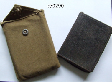 Waverley RSL Sub Branch
New Testament in hand made webbing case, The New Testament of Our Lord and Savior Jesus Christ together with the Book of Psalms, unknown
This book was carried in France and possibly Gallipoli by Sig. H. C. Roussac and the insert "d/0291" was of a Chaplain who obviously had a profound affect on the ownerDemonstrates the religious convictions of some soldiers in WWIBlack leather bound bible with the first page removed by a clean cut. The bible the name of Signaller H. C. Roussac. 25th Battalion A.I.F. and the date Sept 11th 1917. There is a further inscription "Carried through Action "Battle of Ypres" Sept 20th 26th Oct 4th, 9th and 12th consecutively- Wounded Oct. 12th 17- signed H. C. Roussac. There is also what may be an autograph Pt. ? Frogg Masfr??? The bible also contained a lithograph, probably cut from a paper of Chaplain-Captain F. H. King in Egypt The book is contained in a hand stitched khaki webbing case secured by a metal ?uniform button Signaller H. C. Roussac. 25th Battalion A.I.F. and the date Sept 11th 1917. There is a further inscription "Carried through Action "Battle of Ypres" Sept 20th 26th Oct 4th, 9th and 12th consecutively- Wounded Oct. 12th 17- signed H. C. Roussac. There is also what may be an autograph Pt. ? Frogg Masfr???new testament, bible, rev. f. h. king, roussac, ypres, the age, egypt -
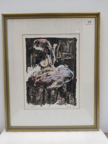 Royal Australian and New Zealand College of Obstetricians & Gynaecologists (RANZCOG)
Print - Lithograph, Peter Jacobs (b. 1949), The Bathroom, 1988
It is likely this item was received from the estate of John 'Jack' Courier. Courier left a bequest to the College consisting of a significant number of artworks by himself and others, including Peter Jacobs.Stone coloured lithograph print of a figure in a bathtub. The head and shoulders of a figure are visible within a bathtub at the centre of the image. The top half of the face of the figure is obscured. There is a mirror visible in the background at the upper right of the image. Handwritten text below image reads " 'The Bathroom' 3/15 Jacobs 88". There is a large auction house sticker printed with the number '82' attached to upper right of reverse of the object. There are also two smaller auction house stickers attached to the upper section of the reverse of the object. Two D-ring fittings and a cord have been added to the reverse of the artwork for hanging. There is a sticker advertising the framer of the work at the bottom centre of reverse.The Bathroom' 3/15 Jacobs 88 -
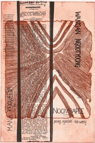 Merri-bek City Council
Etching and lithograph, Vicki Couzens, noombapee, 2018
noombapee is an etching and lithograph by Gunditjmara and Keerray Woorroong artist Vicki Couzens. Couzens is a multi-disciplinary artist focused on strengthening her language and culture through research and creative projects. noombapee was created during a 2018 Collie Print Trust Printmaking Fellowship at the Australian Print Workshop. The work is an example of Couzens’ reclamation and celebration of Indigenous languages. The title is a Gunditjmara term which approximately translates to ‘have mercy’ or ‘forgiveness’. The word ‘noombapee’ appears multiple times in the lower right corner of the composition. The left side of the work includes a letter to the editor of the Warnambool Standard, dated 3 April 1940 and authored by Vicki’s ngapoon (paternal grandfather), Nicholas Couzens. Couzens explains that ‘he was an activist and advocate for our rights living on the Framlingham mission.’ -
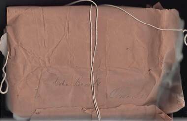 Bendigo Historical Society Inc.
Document - COHN BROTHERS COLLECTION: MANILLA PAPER PARCEL
[a] Brown string bound manilla paper parcel captioned Cohn Bros Ltd, 'Orders'. Varley Bros ,Printers, Stationers, Lithographers label pasted to inside of paper. [b] Parcel contains bundle of printed Cohn Bros cancelled share scrip dating from 1887-97 rather than Orders! Half the number of scrip are tied together with string. The share certificates are numbered in the top left corner and show Cohn Bros Victoria Brewery Company Ltd at the top -Capital 55,000 Pounds in 55,000 shares of 20 Shillings each .Each certificate has a Cohn Bros Brewery seal on the bottom right .There are a number of 1880's Transfer and Acceptance of shares formsbendigo, industry, cohn bros brewery -
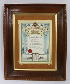 Wodonga & District Historical Society Inc
Certificate - Australian Railways Union, Victorian Branch, Past Officers Certificate, Wodonga Sub-Branch, 1926
The Wodonga line and train station opened in November 1873 when the section of the line from Wangaratta was completed. The expansion of the railways to the northeast of Victoria occurred after the Victorian Government took over the railways in 1867 and the trains serviced large towns such as Seymour, Wangaratta and Wodonga, as well as smaller towns along the way. The north- east train line to Wodonga remained a significant factor in the development of Wodonga as a rural city in the 20th century. The Past Officers Certificate has local significance as it was presented to Wodonga resident, Lachlan McEachern, who was President of the Wodonga Sub-Branch of the Victorian Branch of the Australian Railways Union, and there are other items that belonged to Mr Eachern in the collection of the Wodonga Historical Society. It also has wider significance as an example of a Past Officers certificate dated to the 1920s, as other examples in the collection of Museums Victoria are later and are dated to the 1930s, 1940s and 1950s. Dark brown wooden frame with a lighter brown wood and gold inner border on a Past Officers Certificate from the Victorian Branch of the Australian Railways Union, presented to L. McEachern in 1926, in recognition of services rendered as President of the Wodonga Sub-Branch. The certificate is a colour lithograph with black and white photolithograph images and a red embossed seal. The inscription on the certificate is surrounded by two Corinthian columns and a background illustration of a signal gantry at Flinders St Station. The signatures of the State President and State Secretary are faded. At the bottom of the certificate, there are black and white images of a suburban electric passenger train, "Unity Hall" which is the building where the Australian Railway Union offices were located and a steam train."AUSTRALIAN RAILWAYS UNION" "A.R.U" "AUSTRALIAN RAILWAYS / UNION / VICTORIAN BRANCH" "Presented to / L.McEachern / In Recognition / of Services Rendered / As President / of the Wodonga Sub-Branch /Year 1926" "State President / State Secretary"australian railways union, a.r.u., a.r. u. victorian branch, wodonga sub-branch, victorian railways, v.r., past officers certificate, flinders st station, railway unions, trade unions -
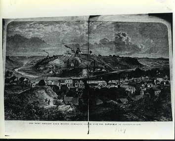 Clunes Museum
Negative - LITHOGRAPH, 1869
FRASER STREET 1869PHOTOCOPY OF LITHOGRAPH OF THE PORT PHILLIP GOLD MINING COMPANY'S CLAIM AND THE TOWNSHIP OF CLUNES TAKEN FROM THE ILLUSTRATED AUSTRALIAN NEWS. JUNE 19 1869. THIS PHOTOGRAPH WOULD HAVE BEEN TAKEN PRIOR TO THE FIRES WHICH DESTROYED THE ORIGINAL SHOPS IN FRASER STREET. ORIGINAL PHOTOGRAPH TAKEN FROM HILL BEHIND OLD LIBRARY IN TEMPLETON STREET, CLUNES. .1 BLACK AND WHITE PHOTOGRAPH MOUNTED ON CARDBOARD .2 BLACK AND WHITE PRINT WITH 'LAYING THE VICTORIAN END OF THE TASMANIAN CABLE ON REVERSE .3 PHOTOCOPY BACKED WITH NEWSPAPER AND PRINT FOR SUPPORT .4 PHOTOCOPY .5 PHOTOCOPY MOUNTED ON CARDBOARD .6 DOCUMENT GIVEN BY HENRY BASSETT, APPEARS TO BE PART OF BROWN ENVELOPE .7 PHOTOCOPY OF PRINT.4 COLAC, VIC AUGUST 8TH 1941. "THIS LITTLE PICTURE PRESENTED TO CLUNES F(REE) L(IBRARY) BY HENRY BASSETT WHO WAS BORN ON CLUNES IN THE SAME YEAR THAT THE ABOVE INSTITUTION WAS ESTABLISHED, AND IS A SON OF THE LATE AZARIAH BASSETT AND NEPHEW OF THE LATE CHRISTOPHER BASSETT WHO WERE BOTH OLD RESIDENTS" HANDED TO SHIRE BY MRS V MCACRAE 22/5/73shops- symons tsymons&co, b.cass maher grocer, pitcher bros., port phillip bakery, bristol mart, and coach office j.h. dalton. -
 Flagstaff Hill Maritime Museum and Village
Book - Bible, Thomas Kelly & Sons, The Holy Bible - Douay Bible and Rheims Testament, 1880
The Douay (Douai) Rheims Bible is an English translation of the Latin Vulgate Bible (which had been the Latin Bible used by the Catholic Church since the 4th century). It was produced by Roman Catholic scholars in exile from Elizabethan Protestant England at the English College of Douai (then in the Spanish Netherlands but later part of France). The New Testament translation was published in 1582 at Rheims where the English College had temporarily located in 1578. The Old Testament was translated shortly afterwards but was not published until 1609-1610 in Douay (which makes it older than the King James version). The completed work was the only authorized Bible in English for Roman Catholics until the 20th Century. Its purpose was to uphold the Catholic tradition in the face of the Protestant Reformation and was produced as an alternative to the several Protestant translations then in existence. Prior to it being published, the Roman Catholic practice had restricted personal use of the Bible, in the Latin Vulgate, to the clergy. Bishop Richard Challoner issued a series of revisions (1749 - 1772) intended to make the translation more easily understandable and subsequent editions (including this one) were based upon this revision. In 1871, an edition of the Douay - Rheims Bible was published by Thomas Kelly & Sons of Philadelphia (and later, New York). Thomas Kelly described himself as a "Publisher, Printer, Binder, Lithographer and Steel Plate Engraver". In 1876, Thomas Kelly won an award (a Diploma of Honor and a Medal of Merit) for "the Best Catholic Bibles and Prayer Books" at the International Centennial Exhibition held in Philadelphia and his firm continued to print editions of the Bible throughout the 1870's but little is known of him after 1880 when this edition was published. This Bible has been in the Kermond family from 1888 until 1984 when Laurence Kermond (its last owner) died. The Kermonds were an old Warrnambool family with ties to the district going back to the mid 1840's. Joseph Kermond's mother, Catherine (1818 - 1895) and her husband John Kermond,, an ex-convict (1809 - 1877), had moved from Tasmania around 1843 and were living in the Warrnambool area in 1844 where their eldest son was born. They had six more children born at Port Fairy (or Belfast as it was then called). Catherine is buried at the Tower Hill cemetery. The last owner of the Bible was Laurence Kermond (1918 - 1984). He was the great grandson of John and Catherine Kermond and was a well known painter who lived in the Merimbula and Paynesville areas of N.S. W. and Victoria during the 1970's and early 1980's. The story of Joseph Kermond finding the Bible on a beach on the Shipwreck Coast near Peterborough on the southern coast of Victoria, Australia is plausible as it was not uncommon for items from shipwrecks to be washed ashore. However this Bible would not have come from the wreck of the Loch Ard as the dates don't align. The Loch Ard was wrecked in 1878 and this Bible was printed in 1880. It appears to have been printed for the Australian market as there is a page (with an engraved portrait) dedicated to the "Most Rev. Roger Bede Vaughan, O. S. B. Archbishop of Sydney, N. S. W.". It may also have been aimed at the Irish immigrants as the four "Family Register" pages are decorated with borders of shamrocks. The donor found the Bible in a box of secondhand books on a market stall in Gippsland and recognised its links to the Shipwreck Coast through the name of previous owners (a well-known Warrnambool name) and the story of it being found on a beach near Peterborough. This Bible is a rare example of Douay and Reims Catholic Bible of the late 19th century that was once a treasured item belonging to the Kermond family - one of Warrnambool's early settlers. It also has a most unusual story attached to it - being found (and rescued) washed up on a local beach and almost one hundred years later, being rescued again from a secondhand book stall.This Catholic Bible is an 1880 edition of a "Douay Bible and Rheims Testament", printed and published by Thomas Kelly of New York. Its full title is "The Holy Bible translated from the Latin Vulgate Diligently Compared with The Hebrew, Greek and Other Editions in Various Languages". It is revised with annotations by the Right Rev. R. Challoner D.D. The Bible has brown leather embossed front and back covers decorated with identical ornate gilt patterns and a central picture of a cross. It has two coloured illustrations and numerous black and white lithographs and engravings including portraits of past popes, events and places from Bible stories and decorative borders. The Bible includes the Old and New Testaments, approbations from Pope Pius the Sixth and Archbishops of the United States and other countries (including Archbishop Vaughan of Sydney), a Family Register with handwritten notes on births, deaths and marriages from the Kermond family (as well as a description of how they obtained the bible), a Catholic dictionary of the Bible, a history of the Holy Scriptures, a chronological list of heretics (Theological history) and a description of the "Centennial Award - Diploma of Honor and medal of Merit" won by Thomas Kelly (for the "Best Catholic Bible") at the Centennial Exhibition at Philadelphia in 1876. The Records section has a note on the Memoranda page written by William John Kennard in 1920.Spine: HOLY BIBLE Title Page: THE/ HOLY BIBLE /TRANSLATED FROM/ THE LATIN VULGATE/ DILIGENTLY COMPARED WITH/THE HEBREW, GREEK AND OTHER EDITIONS/ IN VARIOUS LANGUAGES/ THE OLD TESTAMENT WAS FIRST PUBLISHED BY THE ENGLISH COLLEGE AT DOUAY, A.D. 1600 / AND THE NEW TESTAMENT, BY THE ENGLISH COLLEGE AT RHEIMS, A.D. 1582./ REVISED WITH ANNOTATIONS/ BY THE RIGHT REV. R. CHALLONER D.D./ TOGETHER WITH REFERENCES, AND AN HISTORICAL AND CHRONOLOGICAL INDEX./ NOW CAREFULLY CORRECTED ACCORDING TO THE CLEMENTINE EDITION OF THE SCRIPTURES/ NEW YORK / THOMAS KELLY, PUBLISHER/ 17 BARCLAY STREET. / 1880 Dedication Page: DEDICATION OF THE ORIGINAL EDITION/ TO/ THAT LOYAL, RELIGIOUS AND ENLIGHTENED BODY OF MEN / THE/ CATHOLICS OF THE UNITED STATES OF AMERICA/ IN ADMIRATION OF THE STEADY ZEAL WITH WHICH THEY HAVE KEPTTHE/DEPOSIT OF FAITH/ BEQUEATHED THEM BY THEIR FOREFATHERS/ AND HANDED DOWN, WITHOUT INTERRUPTION OT ADULTERATION, TO THEIR GRATEFUL POSTERITY/ THIS EDITION/ OF THE/DOUAY BIBLE AND RHEIMS TESTAMENT/ IS / WITH GRATITUDE FOR PAST FAVORS AND HOPES OF FUTURE ENCOURAGEMENT/ MOST RESPECTFULLY ENSCRIBED. Handwritten note: ""This Holy Book was found . on the beach . near Peterborough Vic. having been washed ashore . from the wreck of the Loch Ard, (sailing ship) in the year 1888 . By .Joseph . Kermond; and presented to . his mother . Catherine Kermond , who in turn passed it - on . to her youngest . son ; one Jacob Kermond. He in turn presented . it to his son . William John Kermond , (the writer), 23/3/20)" [Original punctuation]flagstaff hill maritime museum and village, warrnambool, shipwreck coast, peterborough, kermond, kermond family, loch ard, bible, douay and rheims bible, catholic bible, thomas kelly and sons publiisher, douai, rheims, holy bible, religious bible, catherine kermond, john kermond, william john kermond' -
 Warrnambool and District Historical Society Inc.
Document, Map: Lady Bay 1853, 1853
This is one of the earliest surveys and maps of Warrnambool harbor, Lady Bay. Being done in 1853, it shows the depths of the bay area marked in fathoms, currents and directions and areas of rocks around mouth of the Merri and the Western side of the bay as well as a large sand spit to the middle right of the beach region.. It also marks the large areas of seaweed and fuci in the outer bay area. It has the area of Pertobe Lagoon marked and shows the early tracks to the town. The engraving work was done by Tulloch and Brown, with Tulloch being one of the earliest engravers and lithographers in the state of Victoria. He arrived in Melbourne in 1849 and set up business with James Davie Brown in 1853 with Brown being a map engraver. They were awarded bronze and silver medals for their work at the Victorian Industrial Exhibition. He also worked in the vignettes on the Proeschel Map of Victoria.This map is of high historical and comparitive significance as it shows the Lady Bay area prior to the changes that have occurred in the last 160 years with the building of the breakwater. The issue regarding access to Lady Bay remains a current one. The engraver D Tulloch engraved some of the earliest scenes of the goldfields in Ballarat and as such has left a record of a very early and important era in Australian history. Rectangular cream paper with black text. Map area is outlined by fine black lined border. Key in top right hand corner and scale at bottom middle of map.Map is labelled Town of Warrnambool printed at top of map. Small logo at top right corner which has “Hydrographic Department” in circle around an anchor. Lady Bay Warrnambool Surveyed by John Barrow assistant surveyor Engraved by Tulloch & Brown in bottom right corner. Melbourne engraved by order of the legislative Council of Victoria in middle bottom.map, warrnambool, town of warrnambool map 1853, tulloch & brown map 1853, lady bay warrnambool,, warrnambool harbour, warrnambool breakwater, warrnambool beach -
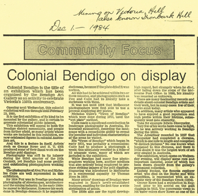 Bendigo Historical Society Inc.
Document - LONG GULLY HISTORY GROUP COLLECTION: COLONIAL BENDIGO ON DISPLAY
Copy of an Advertiser Article titled Colonial Bendigo on display. The article mentions an exhibition organised by the Bendigo Art Gallery to celebrate Victoria's 150th anniversary. Mentioned are the artists George Rowe and S T Gill. The photographers Alex Fox and Nicholas Caire. Thomas Ham introduced engraving in a commercial capacity. Edwin Stocqueler and Ludwig Becker are also mentioned. Written above the article is: Mining on Victoria Hill, also known as Ironbark Hill. Dec 1 - 1984. On the back glass plates are mentioned. Also S T Gills water colours, lithographs and engravings. There is a photograph by Nicholas Caire, taken in 1875, showing the excavation of quartz reef and mine buildings, popper legs and chimneys near Ironbark Hill.bendigo, history, long gully history group, the long gully history group - colonial bendigo on display, bendigo art gallery, george rowe, s t gill, alex fox, nicholas caire, thomas ham, edwin stocquelerthe advertiser, ludwig becker, burke and wills, victoria hill, ironbark hill -
 Kew Historical Society Inc
Document - Invitation to a ‘Conversazione’ in the Exhibition Building, George Austin, 1901
A report in the Ballarat Star on 8 May 1901 recorded that: "THE CONVERSAZIONE. A GREAT SUCCESS. The conversazion given by the Government of Victoria at the Exhibition was very largely patronised. the guests includ ing the Prime Minister and a goodly proportion of the distinguished personages now in Melbourne. A programme of high-class music was gone through, and refreshments were served during the evening. Australian wines were very prominent."The document design has artistic and aesthetic merit. While it is not rare, it is representative of the kinds of formal designs used for the Australian Commonwealth celebrations at the time of Federation, and is in excellent condition. Such items as this invitation have local, state and national historic significance as mementoes of a key moment in Australia's history. Locally, the invitation is part of a group of Federation-related items issued to James Maitland Campbell (and his wife). Campbell was three times mayor of Kew in the second half of the 19th Century and the owner of Ramornie in Pakington Street, one of the significant extant mansions in Kew.Colour lithograph mounted on card to an evening event, a conversazione, held in the Exhibition Building on the evening of Tuesday 7th May 1901, as part of the Australian Commonwealth Celebrations. The recipients of the invitation were Mr and Mrs James Maitland Campbell of Kew. The Government of Victoria hosted the event. The invitation shows an etching of the Exhibition Building, surrounded by an ornate border of heraldic shields, portraits of the Duke and Duchess, views of Perth, Adelaide, Melbourne, Sydney, Brisbane and Hobart, and native flora (including wattle, waratah, pink heath, Sturt’s desert pea, and flannel flower), and native fauna (kookaburra, possum, lyre bird, cockatoo and koala). The royal crest ‘Dieu et mon droit’ and the Australian crest, ‘Advance Australia’ are also included.Printed: UNITED AUSTRALIA 1901 / ONE FLAG / ONE HOPE / ONE DESTINY; AUSTRALIAN COMMONWEALTH CELEBRATIONS / THE GOVERNMENT OF VICTORIA requests the honour of the presence of / / at a Conversazione in the Exhibition Building on the Evening of Tuesday 7th May 1901 at 8 P.M. Handwritten: Mr & Mrs J. M. Campbell.sands & mcdougall ltd, documents - invitations, first commonwealth parliament 1901, james maitland campbell (1847-1930), ramornie, ramornie - pakington street -
 Bendigo Historical Society Inc.
Map - BENDIGO, 1916
Map. Bendigo, Gunbower, Gladstone, Talbot, Dalhousie, Rodney, Jarklan, Calivil, Hayanmi, Mitiamo, Wanurp, Pannoobamawm, Bamawm, Millewa, Ballendella, Janiember West, Janiember East, Pompapiel, Talambe, Dingee, Milloo, Pannoomilloo, Rochester West, Yarrayne, Salisbury, Yallook, Tandarra, Kamarooka, Warragamba, Diggorra, Minto, Bridgewater, Yarraberb, Neilborough, Whirrakee, Egerton, Elmore, Nolan, Goornong, Bagshot, Huntly, Derby, Leichardt, Nerring, Tarnagulla, Woodstock, Marong, Sandhurst, Wellsford, Bendigo, Axedale, Strathfieldsaye, Eppalock, Kimbolton, Lyell, Sedgwick, Mandurang, Lockwood, Ravenswood, Shelbourne, Laanecoorie. Price 3/-. Smaller map of State of Victoria. Lithographed at the Department of Lands and Survey, Melbourne. 1916. Scale : Two miles to one inch. Map was in book form. (number 62 in map cupboard 1)map, bendigo, bendigo -
 Tennis Australia
Lawn tennis set, Circa 1876
A chest (.1), housing a lawn tennis and badminton set. Black and green lithographic print features couples playing mixed doubles tennis and badminton in Cassiobury Park, with Cassiobury House in the background. Inscription: THE CASSIOBURY GAMES OF/BADMINTON AND GARDEN TENNIS/.../LONDON/DEAN & SON 160 FLEET STREET. The hourglass court used in Wingfield's version of lawn tennis is depicted in this lithograph. Contents include: racquets (.2 -.3); tennis balls (.4 - .5); shuttlecock (.6); badminton net (.7); guy ropes (.8 - .9); ornate pegs (.10 - .11); mallet (.12); and net posts (.13 - .14, 2 parts each). Materials: Wood, Metal, Ink, Glue, Paint, Paper, Lacquer, Gut, Rope, String, Velvet, Bird feather, Felt, Rubbertennis -
 Flagstaff Hill Maritime Museum and Village
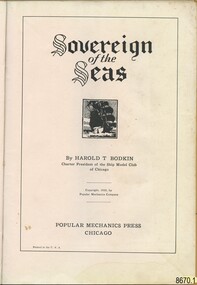
Book - "Sovereign of the Seas" book or manual for the ship model hobby enthusiast, Harold T. Bodkin, 1933, "Sovereign of the Seas", Popular Mechanics Press
Jim (James Bernard) Williams, who was the owner of this manual, was a long-time resident of Warrnambool having the opportunity to work at two notable historical businesses of the town. The first, Cramond & Dickson a drapier store established around 1852-1855 and which remained a store that traded under the same name for the longest in Victoria, before it closed its doors in 1974. The second business was Fletcher Jones a highly successful textile and clothing Australian business. Some of Jim’s spare time was devoted to the model ship making which would conjure up many fascinating stories of maritime history. In addition to Jim witnessing the tail end of ships at port in Warrnambool, his "father was as sea captain and operated his vessel in Bass Strait coastal trade between Tasmania and Victoria". The intricately detailed model made by Jim is full of precise detail. The manual and the blueprints held by Flagstaff Hill Maritime Village also reflect the intricate process and devotion to the task completed by Jim. The history of the shipwreck and maritime stories of the Victorian Southwest coast surrounding Warrnambool would have continued to inspire his passion. Three photos of the model and Jim, like the photo of Harold T. Bodkin in the manual, attest to the enthusiasm and enjoyment that was gained by him through this hobby. The manual opens to a photo of “Mr. Harold T. Bodkin adding finishing touches to model of the “Sovereign of the Seas”. The “Forward to Reader” which is on the next page is written by “E. R. HAAN, Technical Editor, Popular Mechanics Magazine. The forward explains the methodology used to achieve the fine detail that is part of the body of the model, by “applying imitation carvings”, and is cited as “a museum type of model”. The following page “Blueprints and Craftmats on the ‘Sovereign of the Seas’” discusses the availability of a set of blueprints to purchase separately. Followed by a description of the moulding process for the “miniature carvings”. “Historical Notes of Interest on the “Sovereign of the Seas (1637)” follow on the next page. The manual is divided into the following parts from pages 8 to 71: “Part I – Shaping the Hull/Part II – The Rudder, Quarter Galleries and Gunports/Part III Wales, Gunport Covers and Initial Ornamentation/Part V – Beakhead Decoration, Bulkhead and Rails, Etc./Part VI Carvings, Lanterns, Knights, Bitts and Painting/Part VII – Details of Mast Construction/Part VIII – Standing Rigging/Part IX – Running Rigging and Final Details. All of these instructions include photographs and detailed graphs. Then instructions on “How to Read and Use Ship-Model Drawings”, “The Shop-Model Maker’s Tools”, and “Simplified Ship-in-a-Bottle”. This is finished off with “Helpful Hints….” And numerous pages of advertising. Some adverts include aids for completing the “Sovereign of the Seas” model. Part I uses blue and black ink to illustrate a dramatic picture of the “Sovereign”, otherwise all print is in black ink on buff paper. This book in significant to the collection as it was donated along with other tools and blueprints which have been used by the donor of the "Sovereign of the Seas" model ship. It also connects with the wider community in that it is related to historical maritime interest and the donor, Jim Williams is also connected to other significant retail and manufacturing businesses of the past in Warrnambool. This manual has been covered with brown paper, including an extra strip for the spine. The front has a watermark at the top middle, some pencilled compass circles segmented into eight parts across the area and a small amount of script writing. The back also has the same type of compass circles and some other small shapes. There are also grease marks. The cover has a patina adding to variations of colour to the paper indicative of the book being handled often. The title page reads “Sovereign of the Seas” in an Old English font. This is followed by a lithograph print around 1 inch square of a ship at full sale. By HAROLD T. BODKIN/Charter President of the Ship Model Club of Chicago/Copyright, 1933, By Popular Mechanics Company/POPULAR MECHANICS PRESS/CHICAGO/Printed in the U.S.A. By HAROLD T. BODKIN/Charter President of the Ship Model Club of Chicago/Copyright, 1933, By Popular Mechanics Company/POPULAR MECHANICS PRESS/CHICAGO/Printed in the U.S.A.flagstaff hill, warrnambool, shipwrecked coast, flagstaff hill maritime museum, maritime museum, shipwreck coast, flagstaff hill maritime village, great ocean road, model ship, vessel sovereign of the seas, jim williams, james bernard williams, the forth tasmania, freda williams, heather williams, phyllis bowditch, fletcher jones staff 1936, 17th century sailing ship, cramond and dickson, sovereign of the seas, royal sovereign, sovereign, charles 1, fletcher jones, warrnambool breakwater -
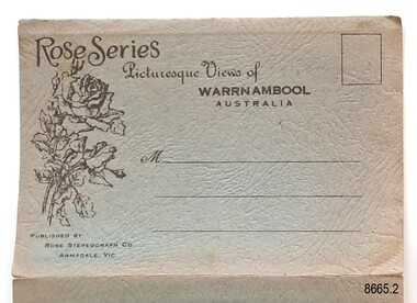 Flagstaff Hill Maritime Museum and Village
Postcard - Postcard Folder, scenes, George Rose, Rose Stereographic Company, Rose Series, Picturesque Views of Warrnambool Australia, 1880-1942
GEORGE ROSE 1861-1942: - George Rose was a well-known Victorian photographer, famous for his late 19th and early 20th century photography. He was born in Clunes, Victoria, and was in his 20th year when he founded Rose Stereograph Company in 1880. He took the opportunity of a popular trend of the times to produce stereographs, pairs of almost duplicate photographs that appeared in 3D when viewed in a handheld stereo viewer. By the 1920s, these lost their popularity, so he used his photographic skills to produce cards and postcards of scenes and people. The twelve photographs in the Rose postcard folders include locations connected to other items in our Collection, including the Valentine postcard folder in this set. The photographs are titled: - . The Avenue and War Memorial. Warrnambool. Vic. . The Blow-hole. Thunder Point. Warrnambool. Vic. . Botanical Gardens. Warrnambool. Vic. . Eagle Rock. Warrnambool. Vic. . The New Concrete Bridge and Breakwater. Warrnambool. Vic. . Liebig Street. Warrnambool. Vic. . Looking to Thunder Point. Warrnambool. Vic. . The Beach. Warrnambool. Vic. . Hopkins Falls. Warrnambool. Vic. . Shelly Beach. Warrnambool. Vic. . The Mouth of the Hopkins River. Warrnambool. Vic. . Panorama of Warrnambool, Vic. [Kepler Street towards Presbyterian Church on Spence St] This postcard folder shows scenes and places of interest in and around Warrnambool. The George Rose postcard folders in this set were produced in Victoria and include pictures taken by the renowned photographer between 1880 and 1942. Other postcards in our collection have photographs of the same or similar locations at different periods in time. Each postcard records a moment in history and is significant as a way to compare and show the changes in the local environment and community, building a story of the local history. The images record changes in the coastline, land, bay, buildings and other structures, roads, transportation and even the fashions of the times. This copy folder is one of a set of three. This folder has a green-grey textured rectangular card cover with a sketch of a rose on the front. The cover also contains the name of the postcard series, the location of the series' focus, the producer's details, and lines for adding an address. The folded cover contains a long, concertinaed page with six titled photographs on each side, totalling twelve. The folder contains scenes from Warrnambool and nearby popular areas, including Lady Bay, the Port of Warrnambool, the Warrnambool Breakwater, the Viaduct, the Merri River Footbridge, the Hopkins River Mouth, and Proudfoot’s and the Fanny Nelson/Flett boathouses. The cover has a sketch of a rose and inscriptions. The lithograph photographs were taken between 1880 and 1942 by well-known Victorian photographer George Rose, Rose Stereograph Company of Armadale, Victoria.Image: [Rose with rosebud and leaves] Printed: "Rose Series / Picturesque Views of / WARRNAMBOOL / AUSTRALIA" "PUBLISHED BY / ROSE STEREOGRAPH CO / ARMADALE. VIC."flagstaff hill maritime museum and village, great ocean road, shipwreck coast, warrnambool, flagstaff hill, flagstaff hill maritime museum, flagstaff hill maritime village, warramble, postcard, postcard folder, warrnambool scenes, picturesque views of warrnambool, lady bay, port of warrnambool, breakwater, warrnambool breakwater, viaduct, merri river footbridge, merri river suspension bridge, suspension footbridge, merri river mouth, hopkins river mouth, proudfoot's, fanny nelson, nelson's boatsheds, nelson's boathouse, boathouse, hopkins river boathouses, flett's boathouse, flett, george rose, image of a rose, rose series, rose stereograph co, rose stereographic company, lighograph, armadale victoria, lady bay beach, beach scene, lower light, concrete footbridge, 1922 footbridge, viaduct road, rose postcard, new concrete bridge, 1945, 1890, 1922, small footbridge, 1872 footbridge, 1872, merri river estuary, stingray bay, postcards, green-grey postcard folder, shipwrecked coast, maritime museum, souvenir, warrnambool local scenes, photography, local history, tourism, photographs, visitors, travel, scenes, mid-20th century, 1940s, 1950s, concertina fold, z-fold, 1880s, collection, correspondence, rose stereograph co armadale, victorian photographer, soldiers’ memorial, hopkins river, the cliffs at shelly beach, the road to sandy beach, pier, botanic gardens, post office, municipal buildings, merri river, proudfoot’s -
 Flagstaff Hill Maritime Museum and Village
Book - Reference, The Elements of Euclid
Author John William Colenso (1814-1883) was a mathematician, missionary and renowned clergyman in the Anglican Church. In 1853 he became the first Bishop of Natal, South Africa. The publisher firm, Longmans, Green & Co., was originally founded in 1724 in London by Thomas Longman under the name Longman. In August of that year, he bought the two shops and goods of William Taylor and set up his publishing house there at 39 Paternoster Row. The shops were called Black Swan and Ship, and it is said that the 'ship' sign was the inspiration for Longman's Logo. After many changes of name and management, the firm was incorporated in 1926 as Longmans, Green & Co. Pty Ltd. The firm was acquired by Pearson in 1968 and was known as Pearson Longman or Pearson PLC. The printer, Spottiswoode and Co,, was established in 1738 by William Strahan, with premises in New Street Square, London. The growing firm advertised as Printers, Lithographers, Stationers, Electrotypers, Publishers, and Booksellers and by 1914 there were 1,000 employees. The book is significant for its connection to 19th-century author John William Colenso, was a mathematician and Anglican clergyman who had several works published. The publisher and printer of this book are also significant in their roles for being established in the early 18th century, contributing to the education of the studies of the scholars of the day. The book is also significant for its connection to the publisher Longmans, Green and Co., of London, and printer Spottiswoode & Co., firms that have been established for around two centuries, renowned for publishing and printing reference works that contributed to the education of scholars over many years.The Elements of Euclid by John William Colenso, D.D. (new edition) [The Elements of Euclid (the parts read in the University of Cambridge) from the text of Dr Robert Simson with Geometrical Examples by John William Colenso, D.D., Lord Bishop of Natal} Date: 1846 Publisher: Longmans Green and Co, London Printer: Spottiswoode and Co, New Street Navy blue textured hardcover on the book, with title on a label on the spine.Text on spineflagstaff hill, flagstaff hill maritime museum and village, warrnambool, maritime museum, maritime village, great ocean road, shipwreck coast, longmans green and co., thomas longman, paternoster row london, john william colenso, 19th-century british mathematician, missionary, spottiswoode & co., the elements of euclid -
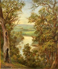 Kew Historical Society Inc
Painting, Herbert J Woodhouse, River Yarra Near Dights Falls, c.1892
Herbert James Woodhouse (1854-1937) was born in Essex and arrived in Australia with his family in 1857. A painter-lithographer like his father and three of his brothers, he was a prizewinner in the South Australian Society of Arts exhibition of 1885. He also received commendations in exhibitions at the Victorian Academy of Arts and the New South Wales Arts Society. At an exhibition of his paintings at Scott’s Hotel in Collins Street in 1892, the reviewer for Table Talk noted that the ‘artist paints almost solely in the open air, and his studies are generally carried out during the trips of the Victorian Sketching Club’. One of the paintings singled out for praise was: ‘A very effective river scene at Willsmere, aptly named A Midstream Mirror, ... a picture powerful in its effective reflection of sunlight in the river.’ Herbert Woodhouse died in Geelong in June 1937, aged 82, and was buried in the Eastern Cemetery. A number of his sketchbooks are held in the collection of the State Library of Victoria.Framed oil painting on board of the River Yarra at Studley Park, Kew, by Herbert James Woodhouse (1858-1937). The artist has framed the narrow painting with trees in the foreground and a view of the Yarra River and rolling hills in the background. Verso, written by artist: "River Yarra Near Dights Falls"australian art - 19th century, herbert james woodhouse (1854-1937), yarra river - studley park