Showing 2286 items matching " parish."
-
 Eltham District Historical Society Inc
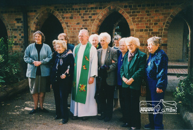
Photograph, Val Rogers, Vicar, (1989-1996), St Margaret's, Eltham wearing a butterfly stole made by the Tapestry Group, and parishoners 3 July 1996
Digital scan of photograph - Original Source Copy: St Margaret's Parish Archives. church of england, churches, eltham, st margarets church, val rogers -
 Eltham District Historical Society Inc
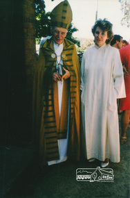
Photograph, Archbishop Sir Frank Woods with daughter Clemence Tapin (nee Woods), All Saints Day, 1 Nov 1987. Clemence was later Assistant Priest 2006-2016
Frank Woods emigrated 1957 to Australia with his wife and 4 children to become Archbishop of Melbourne. Clemence was his daughter.Digital scan of photograph - Original Source Copy: St Margaret's Parish Archives. church of england, churches, eltham, st margarets church, archbishop sir frank woods, clemence tapin (nee woods) -
 Eltham District Historical Society Inc
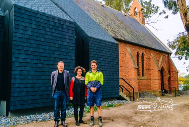
Photograph, The 'new' worship space with the 1861 church, St Margaret's, Eltham, 2014
Digital scan of photograph - Original Source Copy: St Margaret's Parish Archives. church of england, churches, eltham, st margarets church -
 Eltham District Historical Society Inc
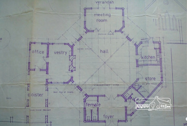
Photograph, An early design for St Margaret's mudbrick hall by architect, Robert Marshall which was not adopted for construction in 1978
Digital scan of photograph - Original Source Copy: St Margaret's Parish Archives. church of england, churches, eltham, st margarets church, mud bricks, robert marshall -
 Port Melbourne Historical & Preservation Society
Book - Novello's Parish Choir book
Novello's Parish Choir book. Office of the Holy Communion. Insert: Six chantsreligion - anglican (holy trinity) -
Bendigo Historical Society Inc.
Map - NERRING SHEET 3, 1/12/1894
Map:Neriing sheet 3. parish plan ( number 188 in Map Cupboard 1)map, bendigo, parish plan, nerring -
Bendigo Historical Society Inc.
Map - HUNTLY RESURVEY, 1873
Map: Huntly resurvey. Parish plan ( number 242 in Map Cupboard 1)map, bendigo, parish plan, huntly -
Whitehorse Historical Society Inc.
Document, Division of Survey and Mapping, 1984
Information guide to Parish and Township Plans - Division of Survey and Mapping - Victorian Government..Information guide to Parish and Township Plans - Division of Survey and Mapping - Victorian Government..Information guide to Parish and Township Plans - Division of Survey and Mapping - Victorian Government..crown lands, victorian government, land surveys -
 Whitehorse Historical Society Inc.
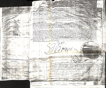
Certificate - Land Title, Willliam Logan, 9/04/1874
Photocopy of original certificate granting William Logan allotment no 144, Parish of Nunawading.logan, william, bowen, george ferguson (sir), land settlement -
 Whitehorse Historical Society Inc.
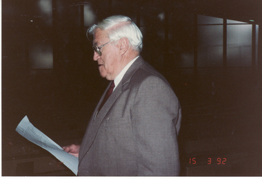
Photograph, Syd Wright, 2/02/1992 12:00:00 AM
Coloured photo of Syd Wright, Parish Historian, at St. John's Church, Mitcham.wright, syd, st. john's catholic church, mitcham -
 Bendigo Historical Society Inc.
Map - KANGAROO FLAT ?, Circa 1880
Map: Parish plan showing area from Kangaroo Flat to Spring Gullymap, bendigo, parish plan, kangaroo flat, spring gully -
 Eltham District Historical Society Inc
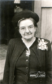
Photograph, Miss Elizabeth Doney
Elizabeth Doney (1880-1958) was a long time resident of Research, Vic. After the death of her parents, brother and sister-in-law she became the care giver for her nephews, while operating the town General Store and later Post Office, which she and before her, her parents managed for over eighty years. Elizabeth was also involved in many community activities including donating land (three house blocks) for the establisment of the Church of the Transfiguration, Research. Digital scan of photograph - Original Source Copy: St Margaret's Parish Archives. church of the transfiguration, elizabeth doney, research (vic.) -
Bendigo Historical Society Inc.
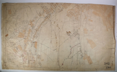
Map - BENDIGO PARISH PLAN
BHS CollectionBendigo Parish Plan Section C Paper with edges bound with canvas tape.bendigo, land sales, parish map -
 Eltham District Historical Society Inc
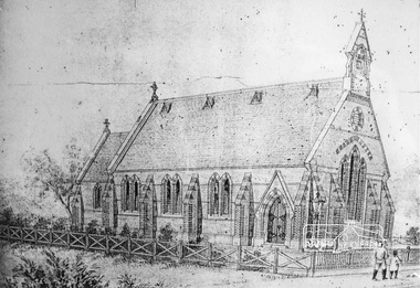
Photograph, Original design sketch of St. Margaret's by Nathaniel Billing, Architect, 1860
Sketch by Nathaniel Billing architect of the larger proposed church put forward to the Church Builidng sub-committee following the decision to build a new church in ElthamDigital scan of photograph - Original Source Copy: St Margaret's Parish Archives. church of england, churches, eltham, st margarets church, nathaniel billing, sketch, st margaret's anglican church, st margaret's anglican church eltham -
 Bendigo Historical Society Inc.
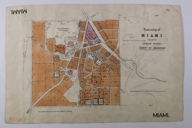
Map - MIAMI ( MIA MIA), 26/06/1906
The name Miami on the is a misprint Map: Township of Miami (Mia Mia), Parish of Spring Plains, County of Dalhousiemap, dalhousie, township, mia mia, spring plains creek -
Bendigo Historical Society Inc.
Map - CAMPBELL COLLECTION: BENDIGO AND DISTRICT MAPS, 9-4-29
Map. Campaspe, Parish of Kimbolton, Scale 20 chains to 1 inch. Total area 4117 acres, Campaspe River, Prepared in W.P.B. by W.J.Galbraith from Parish and Assessment Plans. (number 384 in map cupboard 1)W.J.Galbraithmap, bendigo, agricultural lands -
 Wycheproof & District Historical Society Inc.
Bunguluke Map, Bunguluke District In 1923, 27.2.1923
By 1881 Bunguluke was a small settlement as recorded, December 5, in the Charlton "Mercury". It reports that in that year Draper's Store, Hotel and Post Office and residence at Bunguluke North was totally destroyed by fire. For years now there has been little sign of community life with houses few and far between and acreages have gone into larger holdings. The map references land blocks and owners for that era.This important map shows the local land ownership and local features that existed in 1923. This is a photocopied black and white map of Bunguluke in the County of Kara Kara, Number L5149. Marked - Photo Lithographed by W.J. Butson 27.2.1923. The details include numbers of allotments, property owners, roads, rivers. The boundaries marked are the Parish of Jeruk, Parish of Wycheproof, Parish of Cooroopajerrup. Wycheproof township location is shown with the Scale of Chains. Bunguluke maps for other years are also in the collection.map, bunguluke, jeruk, wycheproof, cooroopajerrup -
Bendigo Historical Society Inc.
Map - DIGGORRA PARISH : COUNTY OF BENDIGO, 6-9-21
Map. Parish of Diggorra, County of Bendigo, Parish of Bamawm, Rochester West, Pannoomilloo, Warragamba, Minto, Egerton, Elmore, Northern Railway, Parish of Ballendella. Elmore /Cohuna Railway. Photo-Lithographed at the Department of Lands and Survey, Melbourne by W.J. Butson, 6-9-21, Price 1/-.. By authority A.J. Mullett, Government Printer. (number 57 in map cupboard 1)A.J. Mullett, Government Printer.map, bendigo, diggorra -
Poowong Historical Group
Land Title Amy Burchett and James Stroud Burchett
Land Title Amy Burchett and James Stroud Burchett 12 January 1903 4 pages2538/507545 LT L/H 3 Part of CA No. 7 Parish of Poowong -
 Federation University Historical Collection
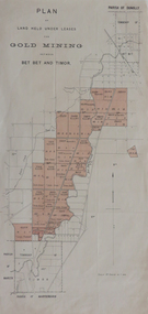
Plan, Land held under leases for Gold Mining between Bet Bet and Timor, not dated
Printed plan with red shading, of gold mining leases between the Parishes of Dunolly and Maryborough.plan, mining leases, gold mining, dunolly, maryborough, bet bet, timor, mining -
Port Melbourne Historical & Preservation Society
Map - Port Melbourne, Department of Lands and Survey, 20 Sep 1932
Dept. of Lands and Survey Map Sheet 5 Port Melbourne, Parish of South Melbourne.Annotated re MHT precincts on foreshore:Plan sketches re boat harbourtown planning, sandridge lagoon, melbourne harbor trust - port of melbourne authority, transport - railways -
Bendigo Historical Society Inc.
Map - JANIEMBER WEST, 18/02/1913
Map: Parish of Janiember West, County of Bendigo ( number 140 in Map Cupboard 1)map, bendigo, rural, janiember west , county of bendigo -
Bendigo Historical Society Inc.
Map - NERRING, August 1952
Map: Nerring, County of Bendigo. Parish plan ( number 180 in Map Cupboard 1)map, bendigo, parish plan, nerring, county of bendigo -
Bendigo Historical Society Inc.
Map - HAWKESTONE, 17/11/1915
Map: Hawkestone, County of Talbot. Parish plan ( number 178 in Map Cupboard 1)map, talbot, parish plan, hawkestone, county of talbot -
Bendigo Historical Society Inc.
Map - HARCOURT, September 1951
Map: Harcourt, County of Talbot. Parish plan ( number 177 in Map Cupboard 1)map, talbot, parish plan, harcourt, county of talbot -
Bendigo Historical Society Inc.
Map - KIMBOLTON, 24/05/1921
Maqp: Kimbolton, County of Bendigo. Parish plan ( number 175 in Map Cupboard 1)map, bendigo, parish plan, kimbolton -
Bendigo Historical Society Inc.
Map - KIMBOLTON, No date Visible
Map: Kimbolton, County of Bendigo. Parish plan ( number 172 in Map Cupboard 1)map, bendigo, parish plan, kimbolton -
Bendigo Historical Society Inc.
Map - WHIRRAKEE, 1971
Map: Whirrakee, County of Bendigo. Parish plan ( number 171 in Map Cupboard 1)map, bendigo, parish plan, whirrakee -
Bendigo Historical Society Inc.
Map - EPPALOCK, 15/11/1928
Map: Eppalock, County of Bendigo. Parish plan ( number 170 in Map Cupboard 1)map, bendigo, parish plan, eppalock -
Bendigo Historical Society Inc.
Map - EGERTON, 1/03/1890
Map: Egerton, County of Bendigo. Parish plan ( number 169 in Map Cupboard 1)map, bendigo, parish plan, egerton