Showing 7614 items matching " road development"
-
 Greensborough Historical Society
Document - Newsletter, Stop the Diamond Village Apartment Complex: Newsletters April/May 2019, 2019
Brochure protesting a proposed high rise residential development at Diamond Village shopping centre2 newsletters, each 1 p., printed both sides in black on white paper, yellow highlights and illustrationsdiamond village shopping centre, diamond village apartment complex, banyule council -
 Greensborough Historical Society
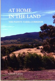
Book, Geoff Lacey, At home in the land: the Plenty-Yarra corridor, 2021
111 p., paperback, col. photographs, mapsnon-fictionindigenous plants, indigenous fauna, plenty river, yarra river -
 Greensborough Historical Society
Magazine, Banyule Banner April/May 2022, 2022_04
The Banyule Banner is published bi-monthly by Banyule City Council to advertise upcoming events in the City of Banyule and to report on past events. This edition contains reports on strategic planning, organics recycling and developments at Barrbunin Beek Aboriginal Gathering Place and Banyule Swamp.A record of events within the City of Banyule.28 pages, colour illustrations. 2 copies.banyule banner, banyule council -
 Greensborough Historical Society
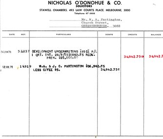
Legal record - Account, Nicholas O'Donohue & Co, Nicholas O'Donohue & Co to Partington 1971, 12/07/1971
A solicitor's account to Alan Partington following a land transaction with Development Underwriting Vic. P/L in 1971. Part of many land deals made by the Partington family in the sale of the original Greensborough farmland.Solicitor's account, black text on white paperalan partington, william alan partington, partington family, land deals greensborough, nullarbor -
 Greensborough Historical Society
Booklet - Report, RBA Architects, Stubley's Hay and Grain Store (Former), 2021
Stubley's Main Street building was constructed in 1935 by the Greensborough Development Company, designed by A. K. Lines, a rare example for Banyule of Moderne influenced style, Citation 4 in the Banyule Heritage Study 202015 p. text and colour photographs, stapledmain street greensborough, banyule heritage study 2020, stubleys hay and grain store -
 Greensborough Historical Society
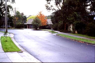
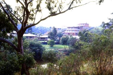
Slide - Photograph, John Ramsdale, Lower Plenty houses: Slide 79, 1990s
Photograph shows a residential street in Lower Plenty - the Plenty River is behind.Part of the John Ramsdale collection of slides and audio visual material.Colour photograph scanned from slide.No caption. Printed maker's mark on slide "Kodak Kodachrome Slide"lower plenty, plenty river, residential development -
 Greensborough Historical Society
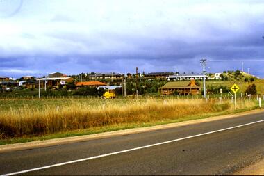
Slide - Photograph, John Ramsdale, Greensborough Bypass near Apollo Parkways: Slide 91, 1990s
Photograph shows houses in foreground and further development in background, including Greensborough Bypass near Apollo Parkways.Part of the John Ramsdale collection of slides and audio visual material.Colour photograph scanned from slide.No caption. Printed maker's mark on slide "Kodak Kodachrome Slide"greensborough bypass, apollo parkways -
 Greensborough Historical Society
Slide - Photograph, John Ramsdale, Encroaching suburbia: Slide 10, 1990s
Photograph shows encroaching residential looking from undeveloped to developed side of Plenty River.Part of the John Ramsdale collection of slides and audio visual material.Colour photograph scanned from slide.No maker's marks. No caption on slide.plenty river, residential development, urbanisation -
 Greensborough Historical Society
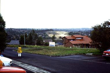
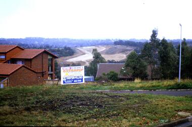
Slide - Photograph, John Ramsdale, Construction of the Western Ring Road: Slide 57, 1990s
Photograph shows residential development with auction board and construction of the Western Ring Road in background.Part of the John Ramsdale collection of slides and audio visual material.Colour photograph scanned from slide.No maker's marks. No caption on slide.western ring road, metropolitan ring road, apollo parkways -
 Greensborough Historical Society
Slide - Photograph, John Ramsdale, Residential development, Whittlesea: Slide 68, 1990s
Photograph shows a residential development in Whittlesea.Part of the John Ramsdale collection of slides and audio visual material.Colour photograph scanned from slide.No maker's marks. No caption on slide.residential development, whittlesea -
 Greensborough Historical Society
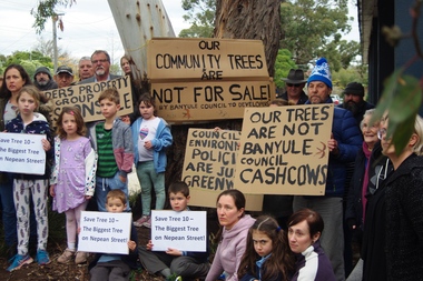
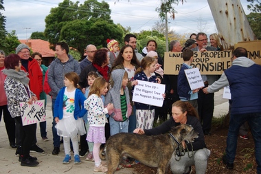
Photograph - Digital Image, Marilyn Smith, Diamond Valley Tree Protest 2019, 25/07/2019
A redevelopment of the Diamond Village area included a multi storey apartment block which required the removal of this tree (Tree 10) on the plans. A VCAT decision ruled that the development be no higher than 4 storeys, and a maximum of 15 dwellings. This photograph shows local residents protesting at the development and removal of tree in July 2019.Digital copy of colour photographdiamond village shopping centre, diamond village, nepean street watsonia -
 Greensborough Historical Society
Photograph - Digital Image, Diamond Valley Tree Protest 2019 - people, 25/07/2019
A redevelopment of the Diamond Village area included a multi storey apartment block which required the removal of this tree (Tree 10) on the plans. A VCAT decision ruled that the development be no higher than 4 storeys, and a maximum of 15 dwellings. This photograph shows local residents protesting at the development and removal of tree in July 2019.Digital copy of colour photographsdiamond village shopping centre, diamond village, nepean street watsonia -
 Greensborough Historical Society
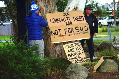
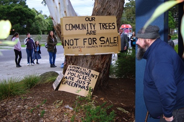
Photograph - Digital Image, Diamond Valley Tree Protest 2019 - signs, 25/07/2019
A redevelopment of the Diamond Village area included a multi storey apartment block which required the removal of this tree (Tree 10) on the plans. A VCAT decision ruled that the development be no higher than 4 storeys, and a maximum of 15 dwellings. This photograph shows local residents placing protest signs at the base of the tree in July 2019.Digital copy of colour photographsdiamond village shopping centre, diamond village, nepean street watsonia -
 Greensborough Historical Society
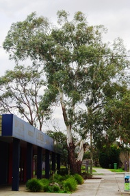
Photograph - Digital Image, Diamond Valley Tree Protest 2019 - Tree 10, 25/07/2019
A redevelopment of the Diamond Village area included a multi storey apartment block which required the removal of this tree (Tree 10) on the plans. A VCAT decision ruled that the development be no higher than 4 storeys, and a maximum of 15 dwellings. This photograph shows Tree 10 in situ in July 2019.Digital copy of colour photographdiamond village shopping centre, diamond village, nepean street watsonia -
 Greensborough Historical Society
Photograph - Digital Image, Diamond Valley Tree Protest 2019 - GHS members, 25/07/2019
A redevelopment of the Diamond Village area included a multi storey apartment block which required the removal of this tree (Tree 10) on the plans. A VCAT decision ruled that the development be no higher than 4 storeys, and a maximum of 15 dwellings. This photograph shows several GHS members at the protest in July 2019.Digital copy of colour photographsdiamond village shopping centre, diamond village, nepean street watsonia -
 Greensborough Historical Society
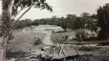
Photograph - Digital Image, Petrie Park Montmorency 1960s, 1960s
Petrie Park Montmorency, 1960s. This photograph shows the early development of Petrie Park, showing a dirt track to the oval and children's play equipment in foreground. The park is situated in Mountainview Road. Today the Montmorency Eltham RSL is also located in Petrie Park.Digital copy of black and white photographpetrie park montmorency, mountainview road montmorency, montmorency eltham rsl -
 Lorne Historical Society
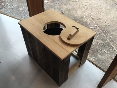
Functional object - Thunderbox, Circa 1930’s
The Great Ocean Road was built by World War 1 returned servicemen. Tolls were collected as sections of the road were completed. The first toll house was at Grassy Creek. It operated from 1922 to 1932 when it was moved to The Springs at Cathedral Rock about 5 km east of Lorne. The thunderbox is believed to have been used here at sometime between 1932 and 1936This is a rare archeological find. Items n this location are often damaged by the action of the sea and salt air. It is intimately associated with the early years of the development of the Great Ocean Road and the daily life of the workers. It is a typical example of the type of toilet used at the time. This reclaimed timber thunder box is enclosed on three sides. There is a circular hole on the top with a wooden handled lid attached by a chain. Inside is a steel can.great ocean road construction, returned sevicemen world war 1, great ocean road toll houses, toilet -
 Koroit & District Historical Society
Crowe Family
Prominent Early Family of KoroitRobert Crowe held several positions of note in Koroit's early developmentPhotocopy -
 Mortlake and District Historical Society
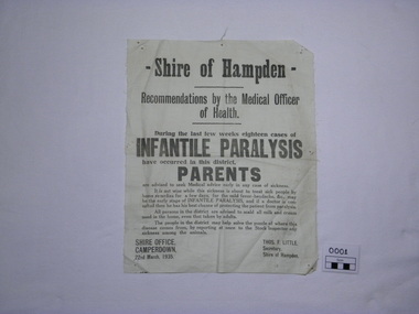
Sign, 22/03/1935
This public notice of 1935 warns of the dangers of Infantile Paralysis. It advises scalding dairy products and reporting stock illness, even though the disease was viral (discovered by U.S. researchers in 1908), not bacterial. There was little chance of protecting children against contracting the disease as the Salk vaccine was not available until 1955, although medical research into the development of preventative serum was well advanced in the 1940's. Treatment of the disease was primitive and a cure not possible.Infantile paralysis was a fearful disease increasingly prevalent in the early 20th Century. Children under 3 were especially susceptible. It could be said to be forever associated with this part of the Western District as a result of the celebrated author, Alan Marshall (1902-1984) suffering its effects. He immortalised his childhood, which was profoundly affected by his paralysis, in the autobiograhical novel 'I can jump puddles'. Calico rectangle off white"Shire of Hampden. Recommendations by the Medical Officer of Health. During the last few weeks eighteen cases of INFANTILE PARALYSIS have occurred in this district. PARENTS are advised to seek Medical advice early in any case of sickness. It is not wise while this sickness is about to treat sick people by home remedies for a few days, for the mild fever-headache, &c., may be the early stage of INFANTILE PARALYSIS, and if a doctor is consulted then he has his best chance of protecting the patient from paralysis. All persons in the district are advised to scald all milk and cream used in the home, even that taken by adults. The people in the district may help solve the puzzle of where this disease comes from, by reporting at once to the Stock Inspector any sickness among the animals. SHIRE OFFICE, CAMPERDOWN, 22nd March, 1935. THOS.F.LITTLE, Secretary, Shire of Hampden." disease, infantile paralysis, poliomyelitis, shire of hampden, public health, childhood -
 Mission to Seafarers Victoria
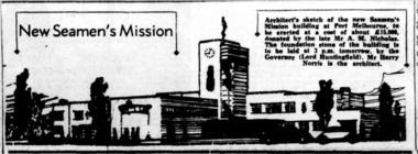
Article - Sketch, Harry Norris, New Seamen's Mission, 17 May 1937
The 1888 building becoming too old and small, a new building was designed by Harry Norris and open in 1937. The funds were given by Alfred Nicholas from the Aspro company. In the Art Deco style, the building was unfortunately demolished in 1995 for a new development.harry norris, port melbourne mission, beach road, 1937, lord huntingfield, alfred nicholas, aspro -
 Greensborough Historical Society
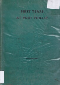
Book, First Years at Port Phillip: by Robert Douglass Boys, 1935_
A history of the discovery of Australia with emphasis on the settlement of Victoria or 'Australia Felix' from the Henty Brothers in Portland in 1834 to the proclamation of the Town Coucil of Melbourne in 1842Chronology of the development of white settlement in VictoriaHard cover, green binding., title in black text on front cover. 158 pages. A chronology of Victoria from 1834 to 1842. Includes newspaper articles relating to the book pasted in front end paper.Inscribed on fly-leaf by author "To A R Kenyon with kind regards R D Boys August 8,1935."victoria-history henty-brothers portland australia-felix melbourne-history -
 Greensborough Historical Society
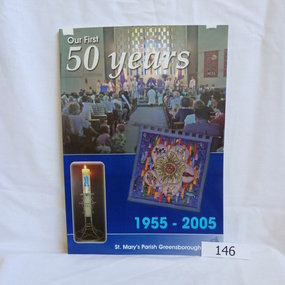
Book, Para Printing Pty Ltd, Our first 50 years: 1955-2005. St Mary's Parish Greensborough, 1955-2005
A history of St Mary's Parish Greensborough compiled to celebrate the 50th anniversary of the founding of the Parish 1955-2005.History of this Parish and those who have contributed to its development.74 pages, colour illustrations, maps. Soft cover with photograph of interior of church.Inside cover in pencil 'Bonnie Dickson', a contributor to the publication.st marys catholic church, greensborough, churches -
 Greensborough Historical Society
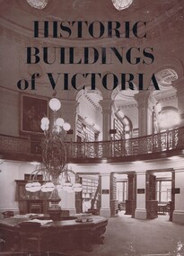
Book, Historic Buildings of Victoria, 1966_
A listing of National Trust listed buildings from around Victoria in 1966. Each entry has a photograph and caption with some history of the building. Arranged by region.The development of architectural style in Victoria.278 pages, black and white illustrations. Hard cover. Dust jacket has illustration of interior of the Library of the Supreme Courtmelbourne architecture, victoria architecture, historic buildings victoria, national trust of australia, victoria -
 Greensborough Historical Society
Newspaper Clipping, Diamond Valley Leader, 40 years young: Greensborough Plaza, 14/11/2018
Includes 2 p. of captioned photographs illustrating development of the Greensborough Plaza shopping centre4 p. supplement in colourgreensborough plaza -
 Greensborough Historical Society
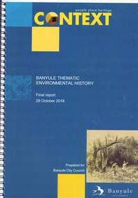
Book, Context (GML Heritage Victoria Pty Ltd), Banyule thematic environmental history: final report, 2018_10
Report on and development of heritage themes relating to forms and places in the City of Banyule area, including places associated with Aboriginal people. Final report prepared for Banyule City Council by Context.82 p., spiral bound, colour and black and white photographs and planscity of banyule, heritage places -
 Greensborough Historical Society
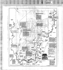
Map, Heidelberg: Historic River Landscape Assessment, Historical Maps. Map A To 1838. Country of the Wawarang, 1985c
Geographical area of around 35 sq. kilometres marked with physical features such as major roads, rivers, vegetation and properties, with contemporary notes on landowners, descriptions and comments on the land and its development. Bounded by Shire of Diamond Valley to the North, Darebin Creek to the West and Plenty River to the East.Black an white sketch map on white paperheidelberg, heidelberg - maps -
 Greensborough Historical Society
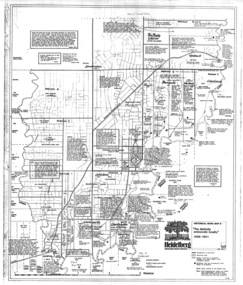
Map, Heidelberg: Historic River Landscape Assessment. Historical Maps. Map B 1838-1851, "The Distinctly aristocratic locality", 1985c
Geographical area of around 35 sq. kilometres marked with physical features such as major roads, rivers, vegetation and properties, with contemporary notes on landowners, descriptions and comments on the land and its development. Bounded by Shire of Diamond Valley to the North, Darebin Creek to the West and Plenty River to the EastBlack and white sketch map on white paperheidelberg, heidelberg - maps -
 Greensborough Historical Society
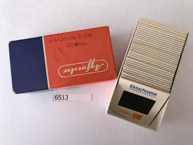
Photographic Slides, Watsonia High School Pool - Photo Slides 1968, 1976-1977
Records the development of the Watsonia High Pool at the Nepean Street Greensborough site during the years 1976-1977. The pool is still operational in 2019 as Yarra Swim School.Primary source material of the beginnings of the pool.36 Kodak slides of in Agfacolor box."Handwritten on box: Watsonia High 2-5-68 H.N." printed on slides: "Processed by Kodak - Ektachrome Transparency".watsonia high school, kodak slides, yarra swim school -
 Greensborough Historical Society
Photographs, Eltham Leisure Centre: re-development, 1991, 26/05/1991
3 photographs of the newly renovated Eltham Leisure Centre 1991, taken by Peter Graham, a Shire of Eltham Councillor. 3 colour photographs.peter graham, eltham, eltham leisure centre -
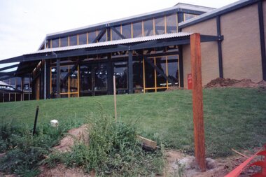
![Document collection, Watsonia development [Lambourn and Devonshire Roads], 2019_](/media/collectors/4f729f5697f83e03086015b8/items/5d82cea121ea6712b80a7cdd/item-media/5d8579dd21ea67168c696120/item-fit-380x285.jpg) Greensborough Historical Society
Greensborough Historical SocietyDocument collection, Watsonia development [Lambourn and Devonshire Roads], 2019_
... Greensborough Historical Society 34A Glenauburn Road Lower ...In 2003, a proposal for a 5 storey building on the corner of Lambourn and Devonshire Roads Watsonia for an apartment complex, medical centre, shops and cafe was approved by VCAT, despite strong opposition by local residents. The proposal did not proceed. In 2019 a proposal for a 2 storey medical centre, cafe and residence was approved for the site and construction commenced. Collection of documents comprising history of development proposals by Rosie Bray, concept illustrations, archtect's plans, photograph and copy of newspaper clipping.watsonia, lambourn road watsonia, devonshire road watsonia