Showing 1526 items
matching aerial photograph
-
 Cheese World Museum
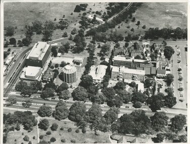
Photograph, Warrnambool Cheese and Butter Factory Co Ltd site 2000 -aerial view, 2000
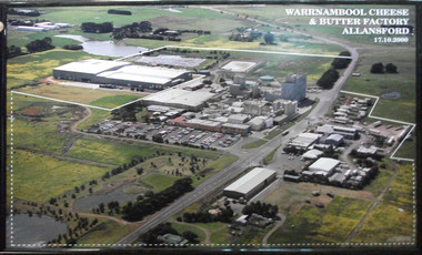
... Aerial colour photograph of Warrnambool Cheese and Butter... 17.10.2000 Aerial colour photograph of Warrnambool Cheese and Butter ...Warrnambool Cheese and Butter Factory Company was formed by a group of Warrnambool business men. The company was registered in May 1888 and commenced commercial production in November 1888. The company retained its independence for more than 125 years until acquired by Canadian firm Saputo. It has operated from the same site since its inception and also has an office in Japan. Milk processing is undertaken by Sungold. Milk powder for export is also produced on-site. Cheese World is a retail arm of the company operates on a connected site selling company products, local food products, wine and cheese tasting. Cheese World Museum operates under the Cheese World umbrella.Aerial colour photograph of Warrnambool Cheese and Butter Factory in wooden frame. Shows buildings and surrounds. Lines indicate factory boundaries, dotted lines indicate property extension. Date is recorded on the image.17.10.2000allansford, warrnambool cheese and butter factory company, saputo, dairyiing, dairy manufacturing, diary manufacturers, cheese, butter -
 Port Melbourne Historical & Preservation Society
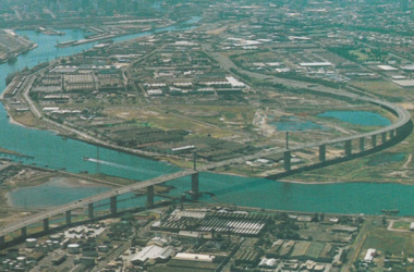
Photograph - Aerial view of West Gate Bridge under construction, 1960 - 1979
... Colour aerial (faded) photograph of West Gate Bridge under... stamped on photo. and on rear Colour aerial (faded) photograph ...Colour aerial (faded) photograph of West Gate Bridge under construction with two land spans incomplete. "Rotten Row" (disused old piers) in the foreground. Aircraft factory and other industry in foreground."Master Copy . Not to be removed from Marketing department " lightly stamped on photo. and on reartransport, engineering, engineering - bridges, fishermans bend, industry, west gate bridge, rotten row, williamstown, yarra river -
 Glenelg Shire Council Cultural Collection
Photograph - Photograph - View of port and facilities, c. 1974
... Black and white photograph. Aerial view taken from...: (no inscriptions) Black and white photograph. Aerial view taken from ...Port of Portland Authority archives.Front: (no inscriptions) Back: (no inscriptions)port of portland archives, portland harbour, k s anderson, no6, no5 berths -
 Bendigo Historical Society Inc.
Photograph - Aerial View Sydenham Gardens Estate Circa 1972
... Photograph: aerial view of Sydenham Gardens Estate Circa... Photograph: aerial view of Sydenham Gardens Estate Circa 1972 ...The Sydenham gardens were set up in 1854 to provide an area of relaxation for diggers. A German, Mr Kraemer, made extensive plantings of ornamentals and fruit trees. The area expanded to 11 acres in 1865 and 25 acres in 1916. T O Hunter owned the gardens from about 1896 and initially it was used for many types of entertainment including, picnics, festivals and sporting events. It was situated off Holdsworth Road in what is now Jackass Flat. T O Hunter was a cordial manufacturer in Macrae Street, who was prominent in many sporting areas. He was President of the Bendigo Coursing Association and raced both dogs and horses. By the time he sold the gardens in 1936 to Mr Muir, he was using the gardens as grazing for his horses.Photograph: aerial view of Sydenham Gardens Estate Circa 1972 , as noted on photo Colour photo, A5 sizephoto sydenham gardens estate, aerial photo -
 Port Fairy Historical Society Museum and Archives
Photograph
... Black and white photograph aerial view of Braim House... house Black and white photograph aerial view of Braim House ...Views from St Johns 1973Black and white photograph aerial view of Braim House Methodist Church and it's Manse with Sunday school in backgroundphoto, st johns, tower, james street, aerial, methodist, weslyian, braim house -
 Ringwood and District Historical Society
Map - State Aerial Survey, Dandenong Ranges Area Sheet 7, Parishes of Warrandyte, Scoresby, Ringwood and Nunawading - 1956
... , July 1956, from aerial photographs and Cadastral Survey... aerial photographs and Cadastral Survey information. Subsequent ...Map of central and southern areas of Ringwood and part of Ringwood East and Heathmont compiled by Dept of Lands and Survey, July 1956, from aerial photographs and Cadastral Survey information. Subsequent coloured hand-drawn additions showing layout of a number of post-NSW Separation era proposed subdivisions that did not eventuate, including Village of Studley Estate, Township of East Kew Estate, Township of Ballyduffy Estate, Township of New Flemington Estate, Township of East Hawthorne Estate. Ringwood A4B2, 849 A4B Zone 7. Scale: 10 chains to 1 inch. Contour interval 20 feet. -
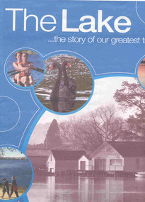 Ballarat Tramway Museum
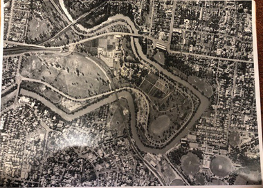
Book, The Courier Ballarat, "The Lake ... the story of our greatest treasure", 6/11/2003 12:00:00 AM
... companies. The centre pages has an aerial photograph of the lake... by local companies. The centre pages has an aerial photograph ...Fifty six page Newspaper supplement, titled "The Lake ... the story of our greatest treasure", published by The Courier, Ballarat, 6 November 2003. Features the history, precincts, life, flora and fauna of the Lake Wendouree and Botanical Gardens. Includes many articles, photographs of the lake, Olympic games rowing in 1956, Ballarat Tramway Museum (p31) with a photo of inside the depot, a timeline and many advertisements by local companies. The centre pages has an aerial photograph of the lake with features numbered, including the depot.trams, tramways, lake wendouree, botanical gardens, olympics, btm -
City of Kingston
Photograph - Black and white, 5 January 1984
... Aerial photograph of Cheltenham, Beaumaris, Moorabbin... Aerial photograph of Cheltenham, Beaumaris, Moorabbin and Highett ...Moorabbin, Cheltenham and Highett are suburbs in the City of Kingston with a diverse mix of development and zoning. The market gardens, farms and paddocks have gradually been sub-divided into housing and industrial estates and associated infrastructure such as schools and shopping facilities. The area includes many parks, reserves and golf courses.This aerial image covers a diverse section of the City of Kingston, taking in the suburbs of Cheltenham, Moorabbin, Beaumaris and Highett. By 1984, the market gardens of the district have been replaced by housing and factories. The Gas and Fuel state-of-the-art Scientific Services Department is visible on Nepean Highway Highett. The CSIRO Highett site can also be seen. Both sites have now been demolished and have undergone remediation. The Southland site is visible and yet to be redeveloped by Westfield. This image portrays the diversity of development in the City of Kingston with a mixture of green spaces, housing and commercial and industrial features.Aerial photograph of Cheltenham, Beaumaris, Moorabbin and Highett within the City of Kingston. The area depicted in the 1984 aerial view includes Eden Street and Edward Street, Cheltenham (top left), Weatherall Road and Reserve Road, Cheltenham/Beaumaris (top right), Turner Road and Chesterville Road, Moorabbin (bottom left), Nepean Highway (left section), Graham Road and Middleton Street, Highett (bottom right). A large section of this image includes Cheltenham Park and Victoria Golf Club.White text: 3831-219 Lens information [indecipherable] RINGWOOD M/S 7922-3 RUN 15 Clockface image 5,300' ASL VIC DLS© 5-1-84cheltenham, highett, industrialisation, urbanisation, moorabbin, beaumaris -
 University of Melbourne, Burnley Campus Archives
Album - Black and white and colour prints, Brian Ward, Freeway Construction, 1963-1972
... ) Aerial photograph of construction of the Freeway near Burnley... yarra brian ward aerial photographs (1) 14 black and white ...(1) 14 black and white photographs showing views of where the Freeway would be going through near Burnley Gardens. (2) 2 photographs of views of the Yarra River near Burnley Gardens. (3) Aerial photograph of construction of the Freeway near Burnley Gardens and Yarra Boulevard. (4) 8 colour photographs of construction work in and over the River Yarra near the railway bridge. "Brian Ward Freeway Construction" handwritten on cover of folder. Student Dux 1973.freeway, burnley gardens, yarra river, yarra boulevard, river yarra, brian ward, aerial photographs -
 St Kilda Historical Society
Photograph, 11 Eildon Road, St Kilda, 1990-2000?
... oringinal colour photograph, TV aerial, cars parked in road... aerial, cars parked in road 11 Eildon Road colour photograph ...oringinal colour photograph, TV aerial, cars parked in roadcolour photograph, unmounted good condition11 Eildon Road -
Glenelg Shire Council Cultural Collection
Photograph - Photograph - berthing of "Aquagem', Portland Harbour, 21/03/1972
... Black and white photograph. Aerial view of berthing...: (no inscriptions) Black and white photograph. Aerial view of berthing ...UnknownBlack and white photograph. Aerial view of berthing of veseel 'Aquagem', using tug 'Tarragal' and others at K.S.Anderson wharf. Unframed.Front: (no inscriptions) Back: (no inscriptions)tug, tarragal, aquagen, k s anderson -
 University of Melbourne, Burnley Campus Archives
Photograph - Black and white print, Aerial View of Burnley Campus c. 1960, c. 1960
... Colour photograph of black and white photograph. Aerial... freeway Colour photograph of black and white photograph. Aerial ...Colour photograph of black and white photograph. Aerial View of Burnley Campus.Enlargement, showing layout of Burnley Campus. Same as B91.296burnley campus, aerial view, yarra river, freeway -
Glenelg Shire Council Cultural Collection
Photograph - Photograph - Portland Harbour, n.d
... Aerial black and white photograph of Portland Harbour... Back: harb023- pencil Aerial black and white photograph ...Port of Portland AuthorityBack: harb023- pencilport of portland archives, portland harbour, henty beach -
Stawell Historical Society Inc
Photograph, Aerial Photos of Stawell from a Hot Air Balloon 1985 -- 11 Photos
... Series of 11 colour photographs of aerial photos of balloon... colour photographs of aerial photos of balloon rides over a town ...Series of 11 Aerial Photos of Stawell. Hot Air Balloon 1985. Photo were taken during a second balloon ride in July 1985. Take off venue was the oval at Stawell West Primary School. The balloon course was parallel to the Western Highway out over Deep Lead. 1. Ride left from Stawell West Primary Oval. 2. School Children were brought out to see the balloon launch. 3. Western Highway Green School oval. 4. Central Park Lower Main St. 5. Taylor's Gully Park Sloane St. 6. Shadow of Hot Air balloon on low cloud over Western Highway. 7. North Western Woolen Mills. 8. Pleasant Creek special school. 9. Looking back at Stawell. 10. Grampians & Lake Lonsdale. 11. Over Deep Lead. Series of 11 colour photographs of aerial photos of balloon rides over a town. stawell -
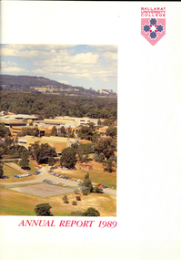 Federation University Historical Collection
Book, Ballarat University College Annual Report, 1989
... Soft covered book with an aerial photograph of the Mount... covered book with an aerial photograph of the Mount Helen campus ...The President of Ballarat University College in 1989 was E.T. Oppy.Soft covered book with an aerial photograph of the Mount Helen campus and Mt Buninyong on the cover. The annual report includes a background of the establishment and governance of Ballarat University College, Remote Sensing Laboratory, Naming of E.J. Barker Library, Computer Centre, Financial Statement The report outlines the completion of the following buildings: * Mt Helen Adminsitration Building * Mt Helen Creche *Physical education Office Extension * Geology Annex the following buildings were commenced: * Staff/Student extension * Librarianship/Business Offices 8 Art extensionballarat university college, oppy, barker, e.j. barker library -
City of Kingston
Photograph - Colour, c. 1993
... Laminated colour aerial photograph of the Carrum... Swamp Canals and waterways Laminated colour aerial photograph ...Patterson Lakes is a suburb in the City of Kingston that is built one kilometre upstream of the mouth of the Patterson River. The area is bordered by the Patterson River and Eel Race Drain which enters the Kananook Creek. The suburb consists predominantly of newer housing developments and the tidal canal system of the development joins Port Phillip Bay.Patterson Lakes and the Kananook Creek were previously part of the extensive Carrum Carrum Swamp. The area was once a source of fish and eels for the Mayone-Bulluk clan of the Bunurong people. Over time the area was drained and in 1973 investigations commenced into the development of a unique residential area that would be built adjacent to canals and waterways. It was originally proposed to be known as "Gladesville". The development would give the suburb's homeowners access to Port Phillip Bay "from their back door". Circa 1974, the area was rezoned from rural to residential and named Patterson Lakes. Development has been continuous since the 1970s with construction of residential housing, schools, shopping centres, marinas, a hotel and library.Laminated colour aerial photograph of the Carrum and Patterson Lakes region within City of Kingston. This 1993 image includes Patterson River Secondary College, Roy Dore Reserve, Kananook Creek and Nepean Highway. The railway line can be seen as it veers inland from Eel Race Road, Seaford. The section of Palm Beach Drive, Curlew Point Drive, Snapper Point Drive, Clipper Island and Myola Street in Patterson Lakes appears to be a recent development with many spare blocks and new houses under construction.patterson lakes, seaford, kananook creek, carrum carrum swamp, canals and waterways -
City of Kingston
Photograph - Colour, 29 January 1993
... Laminated colour aerial photograph of the Bonbeach, Carrum... aerial photograph of the Bonbeach, Carrum and Patterson Lakes ...Bonbeach, Carrum and Patterson Lakes are suburbs in the City of Kingston. Bonbeach and Carrum were holiday destinations in early 20th century and over time the housing has converted to permanent residential structures. In Patterson Lakes, the area consists predominantly of newer housing developments and the tidal canal system which is accessible to many dwellings joins Port Phillip Bay.Bonbeach, Carrum and Patterson Lakes were previously part of the extensive Carrum Carrum Swamp. The area was once a source of fish and eels for the Mayone-Bulluk clan of the Bunurong people. Over time the area was drained and this allowed farming at Carrum and Bonbeach, although the area was prone to flooding. In the early 1920s and 30s the land was converted to residential dwellings. In 1973 investigations commenced nearby to Bonbeach and Carrum into the development of a unique residential area comprising canals and waterways. It was originally proposed to be known as "Gladesville". Circa 1974, the area was rezoned from rural to residential and named Patterson Lakes. Development has been continuous since the 1970s with staged construction of the waterways, residential housing, and supporting infrastructure and facilities.Laminated colour aerial photograph of the Bonbeach, Carrum and Patterson Lakes region within City of Kingston. This 1993 image includes Bonbeach High School prior to demolition, Bonbeach Primary School and Patterson River Golf Club. Sections of Patterson Lakes are not yet developed, including Rhode and Staten Islands. Long Island Point appears to be a recent development with many spare blocks and new houses under construction. The Patterson River marina is prominent and the river mouth as it meets Port Phillip Bay. The Carrum railway station is visible.Black type on white adhesive sticker: No. 6661 Black type on white adhesive sticker: 26E/6661, 29/1/93, 4.25 pm Black type on white adhesive sticker 29-1-93 Yellow circular adhesive stickerbonbeach, carrum, patterson lakes, patterson river, carrum carrum swamp, canals and waterways -
City of Kingston
Photograph - Black and white, 17 January 1951
... Aerial photograph of Cheltenham, Moorabbin and Highett... ↆ M539 Black pencil: N [arrow] Aerial photograph ...Moorabbin, Cheltenham and Highett are suburbs in the City of Kingston with a diverse mix of development and zoning. This 1954 image shows the market gardens, farms and paddocks of the Moorabbin and Cheltenham area. which have gradually been sub-divided into The Highett Gas Works is visible and Cheltenham Park and Victoria Golf Club.The suburbs of Cheltenham and Moorabbin were originally developed with extensive market gardens. Over time the district has been transformed with the farms and paddocks replaced by housing, factories and shopping centres. The Highett Gas Works on the Nepean Highway was a significant feature of the landscape and has now been demolished. and the site has undergone remediation.Aerial photograph of Cheltenham, Moorabbin and Highett within the City of Kingston. The area depicted in this 1951 aerial view includes Wickham Road, Highett (bottom right), Keys Road, Moorabbin (bottom left), Centre Dandenong Road Cheltenham (top left), Park Road, Cheltenham (top right), Nepean Highway (left section), Graham Road and Middleton Street, Highett (bottom right). Cheltenham Park and Victoria Golf Club are visible. Nepean Highway and the Frankston railway line run centrally through the image.White type: 1416-37 538 RUN239 LENS 5312" MELBOURNE METROPOLITAN 12150 17-1-51 ↆ M539 Black pencil: N [arrow]cheltenham, highett, highett gas works, market gardens -
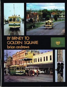 Melbourne Tram Museum
Book, Brian Andrews, "By Birney to Golden Square", 1973
... on the rolling stock with an aerial photograph of Bendigo with the tram..., depot, notes on the rolling stock with an aerial photograph ...Book, 78 pages including card cover, printed on gloss paper, titled "By Birney to Golden Square", written by Brian Andrews, published by Southern Cross Traction, Kensington Park SA. Sub-titled "The last years of Bendigo's tramways", 1973. Features both black and white and colour photographs, including tickets, photos along each route, Charing Cross, depot, notes on the rolling stock with an aerial photograph of Bendigo with the tram routes marked in and a fold out detailed map of Bendigo and its track layout.trams, tramways, secv tramways, bendigo, maps -
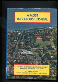 Alfred Hospital Nurses League - Nursing Archive
Book - Illustrated book, Harry W.(Wilfred) Nunn, A most ingenious hospital: history of Sandringham and District memorial Hospital 1940-1990, 1990
... . Front cover has aerial photograph to the hospital c.1990...)'s logo printed in white on spine. Front cover has aerial ...This book covers the history of the Sandringham and District Memorial hospital from when it was first mooted in the early 1940's, through its opening in 1964, until 1990Illustrated book with dust jacket. Hardcover is bound in dark blue, with abbreviated title, authors name, and publisher (Sandringham and district memorial hospital)'s logo printed in silver on spine. Dust jacket back cover and spine is mid blue in colour , with abbreviated title, authors name, and publisher (Sandringham and district memorial hospital)'s logo printed in white on spine. Front cover has aerial photograph to the hospital c.1990 as background, with full title and authors name printed in blue on yellow rectangles with red borders non-fictionThis book covers the history of the Sandringham and District Memorial hospital from when it was first mooted in the early 1940's, through its opening in 1964, until 1990 -
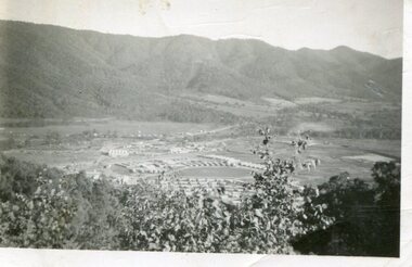 Kiewa Valley Historical Society
Photograph - Mount Beauty from Bogong Hill, 1950
... Black and white photograph - aerial view of Mt Beauty taken... Volox 2428 Black and white photograph - aerial view of Mt Beauty ...The new State Electricity Commission construction camp at the head of the Kiewa Valley was for workmen on the second power station in the project expected to be the most modern and best equipped in Australia… In contrast to the early Kiewa days of horses and canvas tents, the new camp, with its modern amenities, compared favourably with any country town. Administration of the Kiewa Scheme was moved from Tawonga to Mount Beauty in 1946. The first house in Mount Beauty, in Hollonds Street, was occupied by the co-op store manager from November 1946. The new Mess Hall at Mt Beauty was opened with much ceremony in early November 1946. The houses up to Nelse street were erected from 1946 onward and then the township was extended beyond Nelse Street in 1950. The workmen's camp was enlarged in 1950 to the extent of providing accommodation for a total of 1,200.Shows early construction of the town of Mt. Beauty surrounded by farmland taken in 1950 during the early stages of construction of the Kiewa Hydro electric SystemBlack and white photograph - aerial view of Mt Beauty taken from Bogong Hill. Photograph framed by 6mm white boarder.Handwritten on back of photograph in black ink - Mt Beauty from Bogong Hill 1950 Printed on rear Volox 2428mt beauty, bogong hill, secv -
 Warrnambool and District Historical Society Inc.
Map - An Angler's map of the Hopkins River Estuary, Angler's map Hopkins River, 1980s
... of the information has been gathered from aerial photographs. The map has... gathered from aerial photographs. The map has been produced ...This is a map of the Hopkins River Estuary prepared by Dr John Sherwood for the benefit of anglers. The information on the sheet includes the location of sand banks, the water depths, boat ramp facilities and public access facilities. Some of the information has been gathered from aerial photographs. The map has been produced by the Warrnambool Institute of Advanced Education which was developed in the late 1960s from the tertiary section of the Warrnambool Technical College and with all its departments established by 1984 at the Sherwood Campus five kilometres from Warrnambool on the Princes Highway. Today the site is occupied by Deakin University, Warrnambool campus. The Warrnambool Anglers’ Club has its headquarters on the banks of the Hopkins River near the mouth of the river and the Lyndoch Aged Care facility.This map is of interest as a specialist one, providing fishermen with detailed information on all aspects of the Hopkins river estuary. Fishing has been both a profession and a popular recreational pursuit for Warrnambool residents since the early days of the city’s settlement. The Hopkins River Estuary has been a focal point for fishermen throughout Warrnambool’s history. This is a sheet of paper folded three times to produce a folded map. The front cover has a black and white photograph of two fishermen with a large fish. The map of the Hopkins River Estuary is in yellow, blue and black and covers the side of one sheet and three quarters of the other side. There is an advertisement for the Hopkins River Boathouse with a black and white sketch of the boathouse and notes on the map written by Dr John Sherwood. There are several diagrams showing the water depths. The map has some silverfish damage and some tearing at the folds. warrnambool anglers’ club, history of warrnambool, hopkins river, hopkins river estuary, john sherwood -
 International House, The University of Melbourne
Photograph (Item), Aerial view of the site of International House (includes Scheps Building)
... Black and white photograph of Aerial view of the site... Parade Parkville melbourne Black and white photograph of Aerial ... -
Glenelg Shire Council Cultural Collection
Photograph, Aerial view of North West Portland, 1968
... Black and white photograph. Aerial view of North West... and white photograph. Aerial view of North West Portland; wool ...Port of Portland Authority archives.Front: (no inscriptions) Back: WOOL STORES & T.B + S AT NORTH PORTLAND/ PORTLAND HARBOUR TRUST COMMISSIONERS/ JAN 1968port of portland, wool stores, thomas borthwick -
 Port Melbourne Historical & Preservation Society
Postcard - Aerial view of West Gate Bridge, c. 1985
... Colour postcard showing a photographed aerial view... - industrial fishermans bend Colour postcard showing a photographed ...Colour postcard showing a photographed aerial view of the West Gate Bridge. Also visible is the aircraft factory and the industrial area of Fishermens Bendwest gate bridge, engineering - bridges, built environment - industrial, fishermans bend -
![Booklet: Historic Aradale [NMIT Site Plan and Introduction 2003], HiBooklet: Historic Aradale [NMIT Site Plan and Introduction 2003]](/media/collectors/4fac93a2023fd71f703efeec/items/50bbef912162ef06b884a6bc/item-media/50bc39322162ef06b884f20b/item-fit-380x285.jpg) NMIT (Northern Melbourne Institute of TAFE)
NMIT (Northern Melbourne Institute of TAFE)Booklet: Historic Aradale [NMIT Site Plan and Introduction 2003], HiBooklet: Historic Aradale [NMIT Site Plan and Introduction 2003]
... aerial photograph of Aradale campus 2003. Also VHS video Ararat... of Aradale Campus Sunday 17 November 2002. Also large aerial ...Twenty-seven page colour booklet, with introduction and site plans for the Ararat Campus of NMIT, 2003. One large A3 copy and one smaller A4 copy. Also Program for Official opening of Aradale Campus Sunday 17 November 2002. Also large aerial photograph of Aradale campus 2003. Also VHS video Ararat Rural City Council celebrates rebirth of Aradale, Ballarat Win TV State television news 15/3/2002. Bill Braithwaite, Ararat Rural City Council, Peter Ray, NMIT.aradale, nmit ararat, aradale site plan, program for official opening 2002, nmit -
City of Kingston
Photograph - Black and white, 3 March 1954
... Aerial photograph of Mentone, Cheltenham and Moorabbin...] Black pencil: S [arrow] Black ink: 3/3/1954 Aerial photograph ...Cheltenham and Moorabbin are suburbs within the City of Kingston that were originally established as rural market gardening communities The area is bordered by Highett and Mentone. The market gardens, farms and paddocks have gradually been sub-divided into housing and industrial estates. Highett is developed with residential homes but was also the site of major facilities such as the Highett Gas Works. This aerial image covers a diverse section of the City of Kingston, taking in the suburbs of Moorabbin, Cheltenham, Highett and Mentone Residential housing development is prominent along the Frankston Railway line and the area still retains extensive market gardens and paddocks yet to be converted to a large industrial and commercial zone.Aerial photograph of Mentone, Cheltenham and Moorabbin within the City of Kingston. The area depicted in this 1954 aerial view includes Warrigal Road and Centre Dandenong Road intersection (top left); Charman Road, Patty Street, Bourke Street, Collins Street Mentone (top right); Keys Road Moorabbin (bottom left); Bay Road, Cheltenham (bottom right), Friendship Square, Cheltenham Park, Victoria Golf Club and Jack Barker Oval are visible. Nepean Highway and the Frankston railway line run centrally through the image. Highett Gasworks is also evident.White handwriting and type [indecipherable]. White image of clockface White image of compass White type 42956 Black handwriting 3/3/54 Williams [indecipherable] Black pencil: S [arrow] Black ink: 3/3/1954cheltenham, moorabbin, mentone, highett, market gardens -
Glen Eira Historical Society
Document - Classic Retirement Village, Brighton
... Auditor General’s Department website with aerial photograph 2... with aerial photograph 2/A copy of page one of the Gleneira Planning ...Four documents about the history of this site pre Classic Retirement Village: 1/A copy of a description of the sale process of the Gascor site, cnr Nepean Highway and Thomas Street, to Becton Corporation in 1997 And 1998. Printed on 31/07/2010 from the Victorian Auditor General’s Department website with aerial photograph 2/A copy of page one of the Gleneira Planning Scheme dated 19/01/2006 which mentions the Gascor site. 3/Research note by Andrew Frederick dated August 2010 listing occupiers of the site in the 1960 and the 1970 Sands and Mc Dougall Directories. 4/Research note by Claire Barton dated May 2010 containing Ian Swan’s recollections of working at Daylesford Worsted Woollen, occupier of the site, in the 1960s.thomas street, brewer road, bentleigh, gascor, becton corporation pty ltd, virginia park, gas and fuel, hughesdale dairy, east boundary road, moorabin, east bentleigh, hooblerstone, clairmont avenue, glen eira, daylesford centenary woollen and worsted mills pty ltd., nepean highway, f and j industries australia plastic and rubber division., swan ian, korman stanley, mills, wool industry, weaving mills, textile factories, textile manufacturing, manufacturing industry -
Glenelg Shire Council Cultural Collection
Photograph, View of Lady Bay reclaimation and Pivot Fertiliser Works, 21/03/1972
... Black and white photograph. Aerial view of Lady Bay... photograph. Aerial view of Lady Bay reclaimation, Pivot Fertiliser ...Port of Portland Authority archives.Front: (no inscriptions) Back: (no inscriptions)port of portland, lady bay, pivot fertiliser works -
Glenelg Shire Council Cultural Collection
Photograph, Aerial view of Cape Grant, n.d
... Black and white photograph. Aerial view of Cape Grant... and white photograph. Aerial view of Cape Grant quarry from the S.E ...Port of Portland Authority archives.port of portland, cape grant quarry