Showing 15701 items
matching docuents-maps-france
-
 Beechworth RSL Sub-Branch
Functional object - Picture Frame Brass
Item acquired by Pte B.A.Bristow 58848 6th London Regiment in France during his time in France in WWIA rectangular shield shaped and convex brass picture frame with an oval shaped opening for the border of the picture. A tin plate holder is attached to the rear with a heavy gauge copper wire stand Centered at the in scroll the work "SOUVENIR"below the oval border is engraved "1914 - FRANCE - 1919" ; flowers are engraved each side of the oval border -
 Bendigo Military Museum
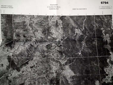
Map - MAP, CUNUNGRA, QLD, Royal Aust. Survey Corps, 1955
Canungra was the Jungle Warfare Training Centre (JTC) before and including 1968. Item in the collection re Lt.Col. Swatton refer Cat No 6719.2P for his service details.This is a full size air photo map. It is black and white. Some natural features are labelled with white printing. The air photo has a white border of approx 6.5 cms size. Map information is printed in black ink around all four borders.Map data = Military survey Australia 1:25,999 Sheet No. 213/2 Zone 8. Scale 1:25,000. Date = The air photo was taken Jan 1955. Map produced by R.A. Survey Corps 1955.passchendaele barracks trust, survey map -
 Greensborough Historical Society
Map, Banyule City, September 1996
... maps ...City of Banyule map, including clubs, leisure, cultural & heritage facilities and other features.Colour map, street index on verso.city of banyule, maps -
Port Melbourne Historical & Preservation Society
Map, Fredrick C COOK C.E.L.S, City of Port Melbourne, Nov 1938
1/600 map of the City of Port Melbourne by City Engineer, Fredrick C COOK.Map of Port Melbourne, November 1938local government - city of port melbourne, fredrick c cook -
 Bacchus Marsh & District Historical Society
Map, Maddingley Township, Parish of Parwan, circa 1890s
Maddingley is a locality or township within the broader township area of Bacchus Marsh. This map is not dated. However features in Maddingley which appeared in the 1880s and 1890s are present in the map, These include the Bacchus Marsh Railway Station and the Bacchus Marsh Showgrounds. The main residential and commercial area of Maddingley is shown on this map in an area bounded by Bacchus Street, Barry Street, Griffith Street and Maddingley Road. Other streets visible are Franklin Street, Inglis Street, Labilliere Street, McCrae Street, Moore Street and part of Station Street.A single page paper map showing land allotments, streets, rivers, creeks, park lands, the railway line and Bacchus Marsh railway station in the township of Maddingley. The map is pasted into a bound volume containing 76 maps or plans in total. bacchus marsh victoria maps, maddingley victoria maps, land use, maddingley victoria history -
 Bendigo Military Museum
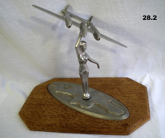
Souvenir - TRENCH ART, c.WWII
Aeroplane model depicts a "P38 Lightning". Belonged to Frederick George CROSBIE VX52187, enlisted in the 2nd AIF on 26.3.1941 age 22 years. At discharge from the Army on 19.12.1945 he held the rank of Pte in the 2/6 Batt AIF. .1) Trench Art. Female figure on map of New Guinea with raised arm holding aloft a model aeroplane. .2) Attached to a wooden lacquered base. The figure and plane are made from aluminium. Map is inscribed "Greetings from New Guinea 1945".trench art, ornaments, metalcraft, handcrafts, souvenirs -
 Bacchus Marsh & District Historical Society
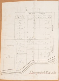
Map, Langmann's Estate Bacchus Marsh
The date of this map has not been determined. It bears the signature of D.A. Little upon of a portion of the map. Little was Bacchus Marsh Shire Secretary and Engineer between 1886 and 1914 which dates the map to some time between 1886 and 1914.A single page paper map showing a portions of land in part of Bacchus Marsh.The area shown is described as Langmann's Estate. The area is bounded by the Werribee River, Fisken Street, Waddle Street(sic.) (Waddell) and Lord Street. The map is pasted into a bound volume containing 76 maps or plans in total. High resolution digital image stored on BMDHS computer network. interim map record stage 1, bacchus marsh victoria maps -
 Mission to Seafarers Victoria
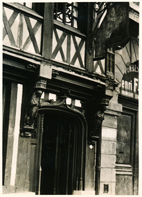
Photograph - Photograph, Black and white, Allan Charles Quinn, Door of an old inn - Rouen, 5 June 1949
This photograph is one of a series taken by Allan Quinn while travelling through France in mid-1946. There are several letters relating to this journey.This is a photograph from the Allan Charles Quinn collection which is a collection of letters and photograph depicting aspects of life at sea for a young man in the era immediately following World War II.A black and white photograph of an inn door, in Rouen, France, taken on the 5th of June, 1949. Two small wooden monks are have carved into either side of the eaves.On reverse: ROUEN 5-6-49 handwritten in blue ink. Below this is the mark "ItI" written sideways in pencil.allan quinn, photograph, rouen, france, normandy, ww2, wwii, world war two, 1939-1945, half-timbered houses -
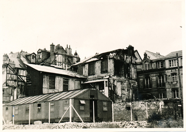 Mission to Seafarers Victoria
Photograph, Allan Charles Quinn, Old residential district - Rouen, 05 June 1949
This photograph is one of a series taken by Allan Quinn while travelling through France in mid-1946. There are several letters relating to this journey.This is a photograph from the Allan Charles Quinn collection which is a collection of letters and photograph depicting aspects of life at sea for a young man in the era immediately following World War II.A black and white photograph of buildings in Rouen, France, taken on the 5th of June, 1949. The building in the foreground is intact, but most of the buildings behind it have been damaged by bombing.On reverse: ROUEN 5-6-49 handwritten in blue ink. Below this is the mark "It" in pencil.allan-quinn, photograph, rouen, france -
Stawell Historical Society Inc
Archive - Maps, Victorian Government, Bailliere's Country Atlas of Victoria, 1866
... Maps ...Stawell is on Wimmera & Loddon MapLarge Boxed Volume of Maps in Book Burgandy Coloured BoxUnder the Supervision of the Mining and Survey Department -
Whitehorse Historical Society Inc.
Map, Blackburn East Primary School
Works Department detail survey.Public 1979. Rolled map. Works Department detail survey.Works Department detail survey.blackburn east primary school no. 4800, victoria. public works department -
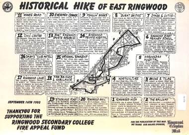 Ringwood and District Historical Society
Document, Historical Hike of East Ringwood -1993
Black and white laminated mapMap includes 20 separate locations of historical interest around East Ringwood. Produced for the Ringwood Secondary College Fire Appeal Fund -September 16th 1993 -
Creswick Campus Historical Collection - University of Melbourne
Map, c.1930?
30 topographical maps, etc dating from 1930's. Subjects: Bendigo, Bendock, Castlemaine, Colbinabbin, Corio, Creswick, Dartmoor, Daylesford, Dunolly, Geelong, Gembrook, Glenmaggie, Juliet, Kaye, Maryborough, Murchison, Ringwood, Stratford, WalhallaMapsSchool of Botany, Univerity of Melbourne -
 Tatura Irrigation & Wartime Camps Museum
Button, K C Luke Pty Ltd
Issued to Sister Kathleen Heaphy of Australian Army Nursing service. Sister Heaphy was attached, for part of her service, to 28 Camp Hospital Internment camp 1.1 round brass button with a metal shank crown and map of Australia and wording around the circumference. Australian Military Forces and a crown and map of Australia. K. C. Luke Pty Ltd Melbourneaustralian army nursing service, sister kathleen heaphy, 28 camp hospital internment camp 1, metal buttons, k c luke pty ltd -
Port Melbourne Historical & Preservation Society
Manual, Collins Street Directory 1961, 1961
This compact Collins Street Directory has 178 detailed maps and shows postal district numbers used at that time.Small directory of Melbourne streets in 1961 including a separate map of all areas covered by the directory & their map reference numbers.built environment - civic, collins book depot {ty ltd -
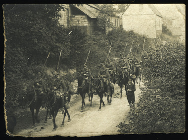 Magnet Galleries Melbourne Inc
British Lancers in France, dargo-098.tif
A group of British lancers moving through a village in France in 1917. For much of the war the British High Command kept immense reserves of cavalry behind the front line in the belief they could exploit successful thrusts by infantry into enemy lines. Pitted against the heavy artillery and the elaborately fortified trenches that typified the First World War, horses proved next to useless. On the back of the photograph its says "British Lancers in France"british, lancers, france, 1917, ww1, world war 1, war, horse, soldiers -
 Mission to Seafarers Victoria
Photograph, New Year 1923 - Jules Michelet, 1923
In January 1923, 5 years after the end of WWI, the two French cruisers Jules Michelet and Victor Hugo went on a tour in South East Asia, Australia and New Zealand consolidating the friendship between the countries. The cruisers arrived in January 1923 and Melbournians were invited to visit the ships. Amongst them the ladies from the Guild. In the "Jottings from Our Log"number 69 dated from January 1923 we can read: Our French Visitors The French cruisers, “Jules Michelet” and “Victor Hugo”, each with a complement of 26 officers and 747 men, paid a visit to this port towards the end of the year. Many of the sailors made good use of our institute, and were supplied with French magazines and papers, and were delighted to find that quite a number of ladies could speak French fluently. Over one hundred men were present at the Institute on one of our special nights during Christmas week, when each French visitor was supplied with refreshments and a cigar. Through the great kindness of some of our ladies, each man aboard the two cruisers was supplied with a packet of cigarettes. These were greatly appreciated by the men, and a warm letter of thanks was received from each of the captains."Reflects strong community and LHLG links via the Mission and as a result of WW1 support and fundraising efforts.Sepia tone blurry photograph with a white frame depicting two French seafarers with their traditional uniform and beret on shore near a pier shed children or women in the far distance at lwr right.Handwritten at the back in pencil: New Year 1923 Jules Micheletfrench cruiser, jules michelet, victor hugo, wwi -
Whitehorse Historical Society Inc.
Map, Parish of Nunawading, 1892
... Maps ...Map copied from 'Directory maps - parishes and counties' 26 Nov 1892.Map copied from 'Directory maps - parishes and counties' 26 Nov 1892. Lithographed by G.S. Bonne[y]. Map includes roads, railway, stations, names of property owners. 2nd copy 'for copying'.Map copied from 'Directory maps - parishes and counties' 26 Nov 1892. maps, parish of nunawading -
Greensborough Historical Society
Maps, Plenty River, 1837o
... Maps ...These maps show the land use along the Plenty River. Both Aboriginal and white settlements are shown.Set of maps showing the Plenty River. -
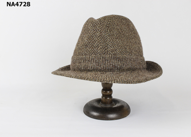 Whitehorse Historical Society Inc.
Headwear - Hat
Purchased in England and worn by donor's husbandBrown Tweed TrilbyTempercork Pariscostume, male headware -
Frankston RSL Sub Branch
Knife, Butter
This is a trench art butter knife. The handle is made of a plated spent bullet cartridge and the blade is made from brass. The blade is engraved with a delicate pattern which is quite worn. On one side are the words "Souvenir France". The cartridge is the type used by the German Mauser and is stamped with a manufacturing date of 1918. The blade of this knife is engraved with the words "Souvenir France". The end of the cartridge is stamped ".D. SE 4 18"great war, world war 1, ww1, trench art, bullet, france, sovenir, -
Marysville & District Historical Society
Map (item), Taungurung Land and Waters Council Aboriginal Corporation, Unknown
A map of the area in Victoria which is the land of the Taungurung Clan.A map of the area in Victoria which is the land of the Taungurung Clan. Taungurung Land and Waters Council (TLaWC) was registered 16 July 2009 as the Registered Aboriginal Party that represents the interests of the Taungurung people. TLaWC is the corporate representative and ‘face’ of the Taungurung people and serves to uphold their interests with respect to culture and country. The Taungurung people occupy much of central Victoria. Their country encompasses the area between the upper reaches of the Goulburn River and its tributaries north of the Dividing Range. From the Campaspe River to Kilmore in the West, eastwards to Mount Beauty, from Benalla in the north down to the top of the Great Dividing Range, their boundaries with other Aboriginal tribes are respected in accordance with traditional laws.taungurung clan, taungurung land and waters council aboriginal corporation, victoria -
Whitehorse Historical Society Inc.
Map, Nunawading Map. Large Scale, 1960's ?
... Maps ...Sheet 2, Nunawading map. Sections 78 -97.Sheet 2, Nunawading map. Sections 78 -97.Sheet 2, Nunawading map. Sections 78 -97.maps, nunawading -
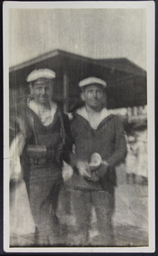
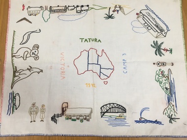 Tatura Irrigation & Wartime Camps Museum
Tray Cloth, Exodus of Templers to Australia, 1942
Calico brought from Palestine and embroidered in camp 3 by 14 year old Anne Marie Treftz (now Mrs Anne Marie Reugg)Calico tray cloth, embroidered in many colours, around the 4 edges with scenes depicting the progressive exodus of the Templers from Palestine to Australia by bus, train, camel, and super liner the Queen Elizabeth. Sydney Harbour Bridge, Army personnel and unique Australian fauna. In the centre is an embroidered map of Australia. Around the map are the words: Tatura Camp 3 1942 VictoriaAround the Map of Australia- words Tatura- Camp 3- 1942- Victoriatatura, tray cloth, treftz, anne marie, palestine, kazenwadel, kurt, camp 3, reugg, templers, handcrafts, embroidery, manchester, table, linen -
 Greensborough Historical Society
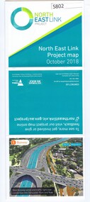
Leaflet, North East Link Authority, North East Link: project map October 2018, 2018_10
North East Link Authority was set up to lead development of this project. This map shows the proposed route with major intersections/interchanges. Map, colour text and images.north east link -
 Greensborough Historical Society
Map, Victoria. Department of Crown Lands and Survey, Keelbundoora; Counties of Bourke and Evelyn, 1950c
Map of the Victorian counties of Bourke and Evelyn showing parish boundaries and land ownership.Show the original landholders for this area.Map on light brown parchment, covered in plastic."L.5305" and "3462" -
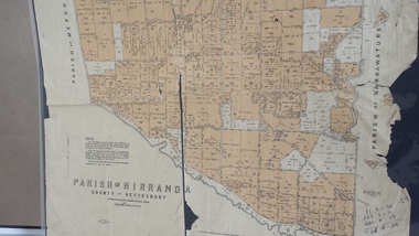 Peterborough History Group
Map - Map of the Parish of Nirranda, Parish of Nirranda
... Maps ...Map of the Parish including roads, names of landowners, location of schools etc in 1939A3 size map of the Parish of Nirranda in 1939nirranda, maps, parish map -
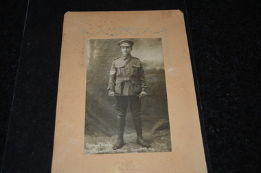 Wangaratta RSL Sub Branch
Memorabilia - Unframed Photograph, Courtney's Thelma Studio, Wangaratta, Cyril Buckler
Studio portrait of 5347 Private Cyril Buckler, 14th Battalion. A postman from Wangaratta, Victoria, prior to enlistment on 16 February 1916 he embarked from Melbourne aboard HMAT Euripides on 4 April 1916 for Egypt. His unit relocated to the Western Front, France, in June 1916. Pte Buckler was killed in action near Pozieres, France, on 7 August 1916. He has no known grave and he is commemorated on the Villers-Bretonneux Memorial. This photograph of Cyril Buckler in the rank of Sergeant was probably taken while he was serving in the Senior Cadets or the Citizen Forces prior to enlistment in the AIF.Cyril Buckler was a postman in Wangaratta prior to enlisting in the AIF on February 16 1916 at the age of 19 years 11 months. He was killed in action on August 7th 1916 near Pozieres in France aged 20 years. He has no known grave. His military service record revealed his parents named their property "Pozieres" after his death.Unframed black and white photograph mounted on light brown cardboard of soldier holding whip.Sgt Cyril Buckler Killed in Action in France August 7th 1916wangaratta, kia 7/8/1916, cyril buckler 5347 -
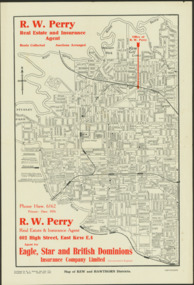 Kew Historical Society Inc
Map - Map of Kew and Hawthorn Districts
Map of Kew, East Kew and Hawthorn produced for a Kew Real Estate Agent, RW Perry. The map is undated.Two-colour map of Kew and Hawthorn Districts produced for by R.L. Jarrett for RW Perry, Real Estate & Insurance Agent. The map has unusual features such as a planned railway link from Kew Station to the former Outer Circle Railway. RW Perry / Real Estate & Insurance Agent, 602 High Street, East Kewmaps - kew (vic), maps - hawthorn (vic), r.w. perry, real estate agents -- kew (vic.) -
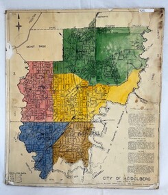 Greensborough Historical Society
Poster - Map, City of Heidelberg, 1965c
Map of the City of Heidelberg sowing municipal boundaries and Wards are coloured. Scale 20 chains to 1 inch.An example of hard copy plans from the 1960s. Mainly from the Shire of Diamond Valley era (1964-1994).Colour map, pasted on card and laminated.Stamped and handwritten Council permissions, dates and other details. city of heidelberg